Last Updated on 1st June 2024 7:15 PM by AfriWX
THE REGIONAL WEATHER FORECAST
FOR TOMORROW 2024-06-02
ISSUED AT 1600 SAST
BY THE SOUTH AFRICAN WEATHER SERVICE. THIS FORECAST WILL BE UPDATED AT 0500 SAST.
SEVERE WEATHER ALERTS
IMPACT-BASED
WARNINGS
A. Yellow Level 6 Warning for disruptive rain resulting in flooding of settlements, roads and bridges, some communities temporarily cut off as well as danger to life is expected in places over the coastal area and adjacent interior of the eastern half of the Eastern Cape. B. Yellow Level 2 Warning for disruptive rain resulting in flooding of settlements, roads, low-lying areas and bridges is expected in places south of the escarpment of the Eastern Cape as well as along the coast of the western half of the Eastern Cape. C. Yellow Level 2 Warning for Damaging Wind and Waves localised disruptions to harbours and/or ports, difficult driving conditions along coastal routes/ roads and choppy seas, as well as possible coastal infrastructure damage in exposed bays are expected along the coast between Cape Point and Coffee Bay. D. Yellow Level 1 Warning for severe thunderstorms resulting in strong damaging winds and hails expected over the North West, eastern parts of Northern Cape, Free State, Gauteng as well as in the northern interior of the Eastern Cape, where it will be disruptive rain, leading to localized flooding. FIRE DANGER
WARNINGS
Nil. ADVISORIES Very cold, wet and windy conditions expected to set in on Sunday over the southern parts of the Northern Cape, the central and eastern interior of the Western Cape and Free State, spreading to the northern high ground of the Eastern Cape on Monday. These conditions likely to persist into Monday with a possible snowfall on the high ground of the Western and Eastern Cape as well as over the southern parts of Northern Cape.
PROVINCIAL WEATHER OVERVIEW
GAUTENG PROVINCE
Fine in the morning, otherwise cloudy and cool with scattered showers and thundershowers but isolated in the north where it will warm in places. The expected UVB sunburn Index Low
MPUMALANGA PROVINCE
– Morning fog over the extreme south-east, otherwise partly cloudy and cool to warm with isolated showers and thundershowers, except over the Lowveld, but scattered in the south-west where it will become cloudy.
LIMPOPO PROVINCE
– Partly cloudy and cool to warm with isolated showers and thundershowers in the south-west. It will be fine over the Lowveld.
NORTH-WEST PROVINCE
– Partly cloudy and cool to warm, with isolated showers and thundershowers but scattered in the extreme south where it will be cloudy.
FREE STATE
– Cloudy and cold to cool, with scattered showers and thundershowers.
NORTHERN CAPE
Fine in the west otherwise partly cloudy and cold to cool with isolated showers and thundershowers except in the extreme north. The wind along the coast will be light and variable becoming light south-easterly to easterly from the evening.
WESTERN CAPE
Morning fog can be expected along the western interior, otherwise partly cloudy and cool to cold with light isolated light showers along the south coast in the morning. Scattered showers and thundershowers are expected over the eastern interior in the evening spreading to the south coast. The wind along the coast will be light north-westerly in the west but fresh to strong easterly along the south coast at first moderate towards the afternoon. The expected UVB sunburn Index Low
WESTERN HALF OF THE EASTERN CAPE
Cloudy and cold to cool with scattered showers and thundershowers, but widespread in the south-east. The wind along the coast will be strong to gale force easterly, but north-easterly in places.
EASTERN HALF OF THE EASTERN CAPE
– Cloudy and cold to cool with widespread showers and thundershowers, but scattered in the north-east. The wind along the coast will be fresh to strong easterly, reaching Gale force in places south of Port St Johns.
KWAZULU-NATAL
– Cloudy and cool with scattered showers and thundershowers but isolated in the north-east where it will be warm. The wind along the coast will be moderate to fresh easterly to north-easterly, becoming strong in the evening. The expected UVB sunburn Index Low .
JOIN OUR FREE AFRIWX WEATHER GROUP on Telegram Messenger
Please download Telegram for Android or iPhone if you want to always be up to date with the latest weather maps.
CLICK HERE TO JOIN our Telegram Group Now
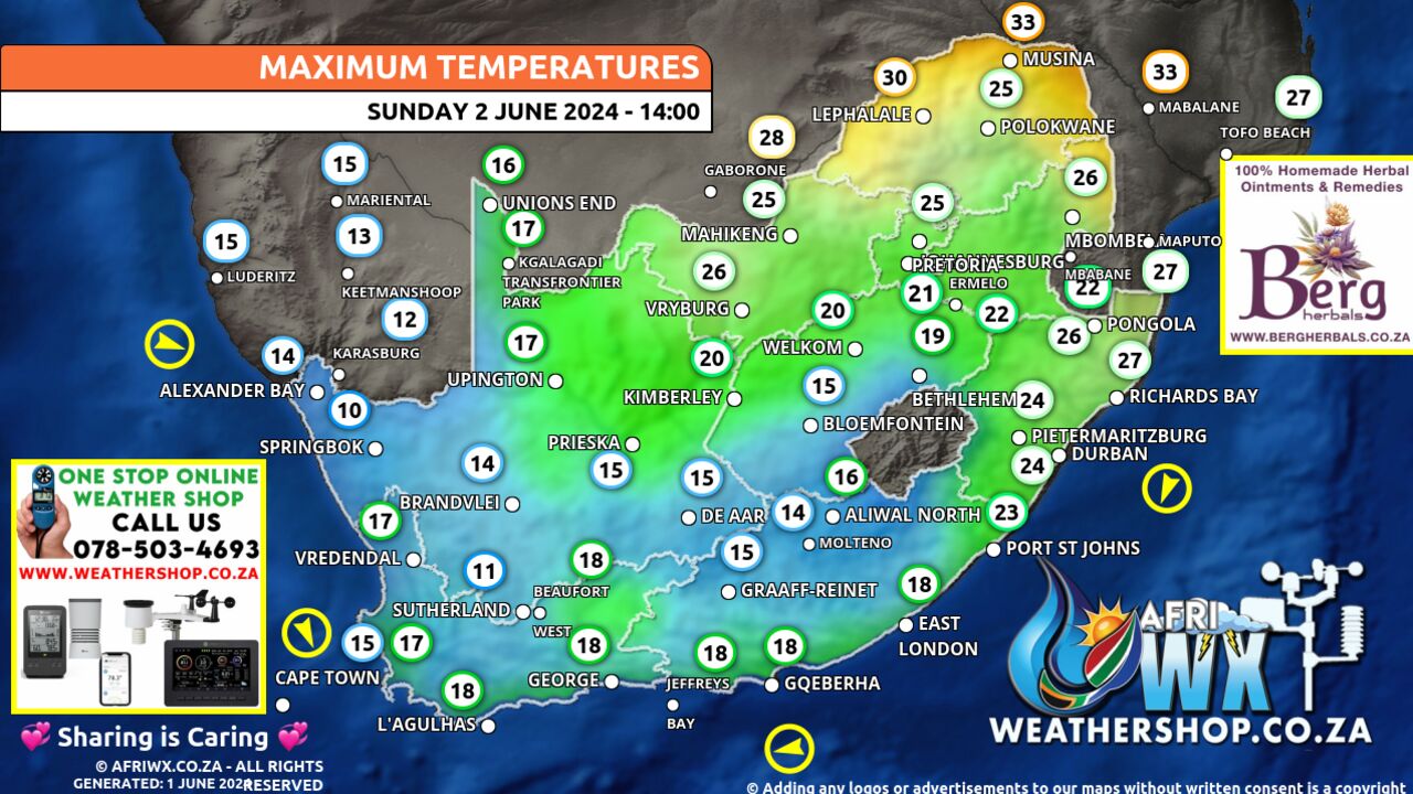
Maximum Temperatures Forecast for South Africa Sunday 2 June 2024
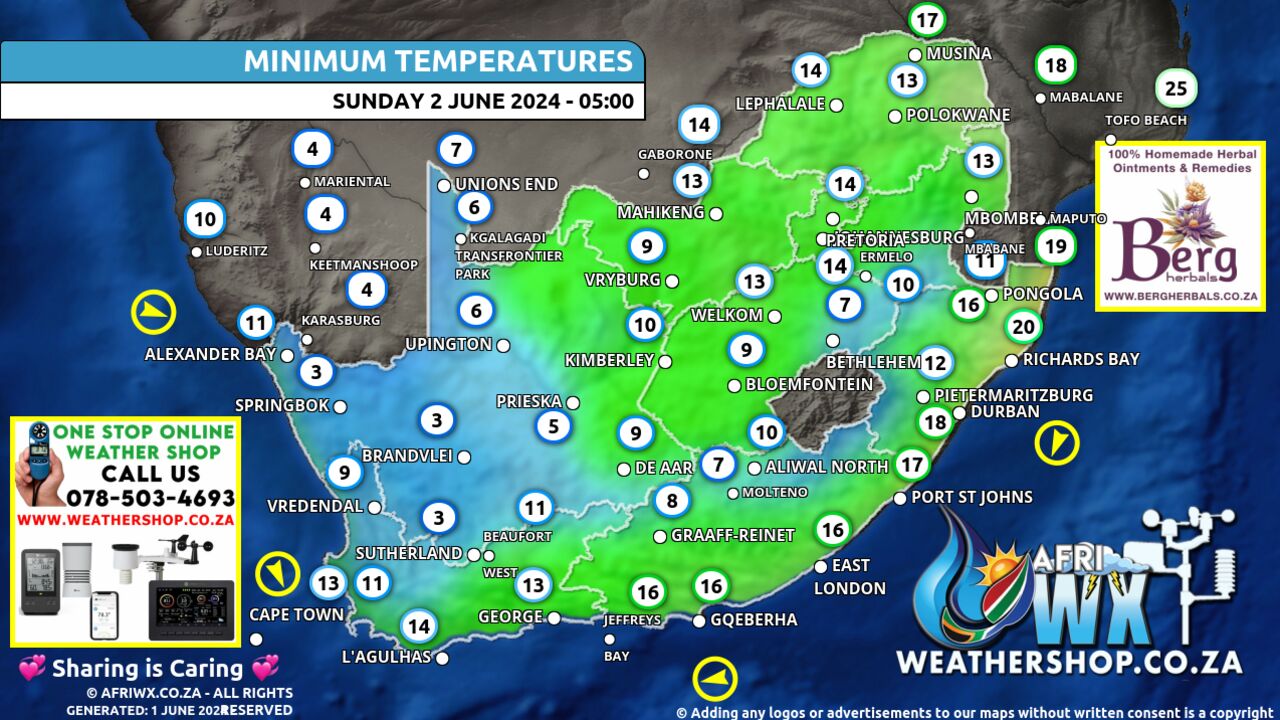
Minimum Temperatures Forecast for South Africa Sunday 2 June 2024
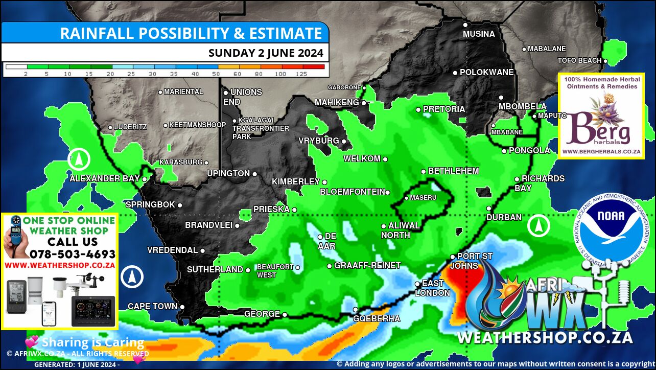
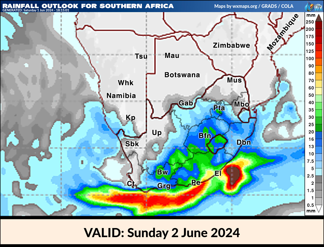
Rainfall Outlook for South Africa Sunday 2 June 2024
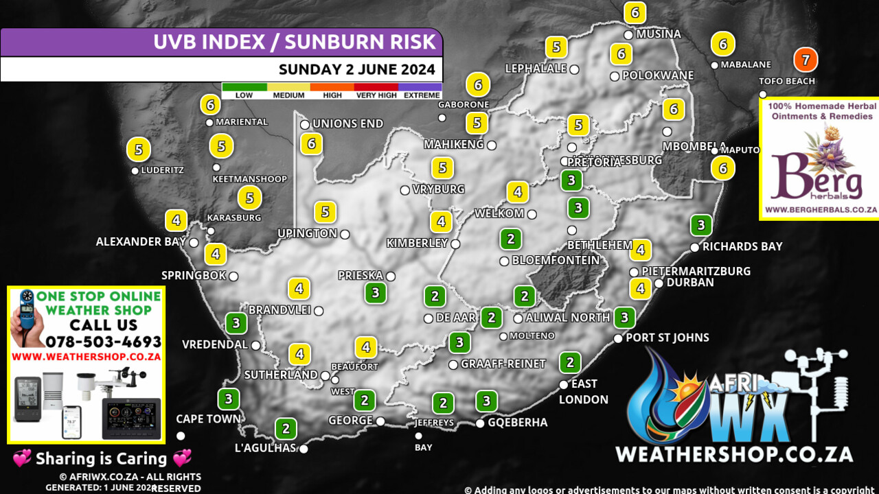
UVB Index Outlook for South Africa Sunday 2 June 2024
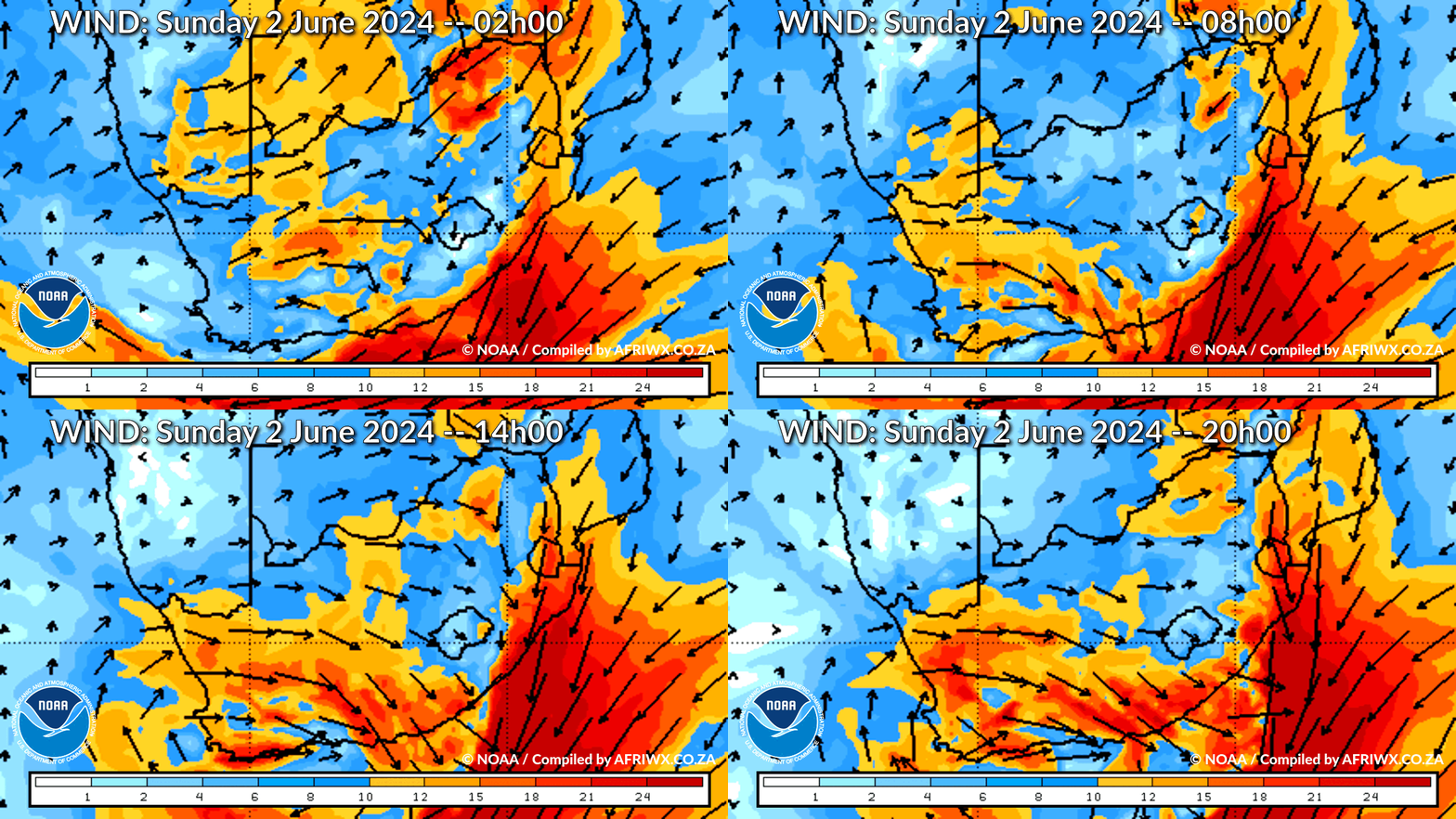
Wind Speed Direction and Gusts Map for South Africa Sunday 2 June 2024
TRAVELLERS WEATHER FORECAST
FOR TOMORROW 2024-06-02
ISSUED AT 1530 SAST
BY THE SOUTH AFRICAN WEATHER SERVICE.
SEVERE WEATHER ALERTS
IMPACT-BASED
WARNINGS
A.
Yellow Level 6 Warning For Disruptive Rain resulting in flooding of settlements, roads and bridges, some communities temporarily cut off as well as danger to life is expected in places over the coastal area and adjacent interior of the eastern half of the Eastern Cape.
B.
Yellow Level 2 Warning For Disruptive Rain resulting in flooding of settlements, roads, low-lying areas and bridges is expected in places south of the escarpment of the Eastern Cape as well as along the coast of the western half of the Eastern Cape.
C.
Yellow Level 2 Warning For Damaging Wind And Waves Localised disruptions to harbours and/or ports, difficult driving conditions along coastal routes/ roads and choppy seas, as well as possible coastal infrastructure damage in exposed bays are expected along the coast between Cape Point and Coffee Bay.
D.
Yellow Level 1 Warning for Severe thunderstorms resulting in strong damaging winds and hails expected over the North West, eastern parts of Northern Cape, Free State, Gauteng as well as in the Northern interior of the Eastern Cape, where it will be disruptive rain, leading to localized flooding.
FIRE DANGER
WARNINGS
– Nil.
ADVISORIES – Very cold, wet and windy conditions expected to set in on sunday over the southern parts of the Northern Cape, the central and eastern interior of the Western Cape and Free State, spreading to the northern high ground of the Eastern Cape on monday.
These conditions likely to persist into monday with a possible snowfall on the high ground of the Western and Eastern Cape as well as over the southern parts of Northern Cape.
WEATHER IN OUR TOP CITIES
PRETORIA
Partly cloudy with isolated afternoon showers and thundershowers.
Minimum/Maximum 11/24 The expected UVB Sunburn Index Low
JOHANNESBURG
PARTLY cloudy with scattered afternoon showers and thundershowers.
Minimum/Maximum 8/21
VEREENIGING
Partly cloudy with scattered afternoon showers and thundershowers.
Minimum/Maximum 7/22
MBOMBELA
Partly cloudy.
Minimum/Maximum 11/24
POLOKWANE
Partly cloudy.
Minimum/Maximum 9/25
MAHIKENG
– Partly cloudy with isolated showers and thundershowers.
Minimum/Maximum 13/23
VRYBURG
Partly cloudy with isolated showers and thundershowers.
Minimum/Maximum 10/23
BLOEMFONTEIN
Cloudy with scattered showers and thundershowers.
Minimum/Maximum 10/15
KIMBERLEY
Cloudy with scattered showers and thundershowers.
Minimum/Maximum 9/17
UPINGTON
Partly cloudy with isolated showers and thundershowers Minimum/Maximum 7/18
CAPE TOWN
Partly cloudy.
Wind moderate north-westerly.
Minimum/Maximum 10/15 The expected UVB Sunburn Index Low
GEORGE
Cloudy with isolated light showers in the morning but scattered thundershowers in the afternoon.
Wind Moderate to fresh easterly.
Minimum/Maximum 9/18 GQEBERHA – Cloudy with widespread showers and rain, but thundershowers in the afternoon.
Wind Strong to Gale force easterly, becoming strong north-easterly in the evening.
Minimum/Maximum 13/18
EAST LONDON
Cloudy with widespread showers and thundershowers.
Wind Fresh to strong easterly, becoming north-easterly in the afternoon.
Minimum/Maximum 15/20
DURBAN
Cloudy with isolated showers and thundershowers.
Wind Moderate to fresh easterly to north-easterly in the morning, becoming strong in the evening.
Minimum/Maximum 18/23 The expected UVB Sunburn Index Low
RICHARDS BAY
Cloudy with isolated showers and thundershowers.
Wind Moderate to fresh easterly to north-easterly in the morning, becoming strong in the evening.
Minimum/Maximum 20/25
PIETERMARITZBURG
Cloudy with scattered showers and thundershowers.
Minimum/Maximum 10/23
JOIN OUR FREE AFRIWX WEATHER GROUP on Telegram Messenger
Please download Telegram for Android or iPhone if you want to always be up to date with the latest weather maps.
CLICK HERE TO JOIN our Telegram Group Now
Rainfall Outlook for Tomorrow Sunday 2 June 2024
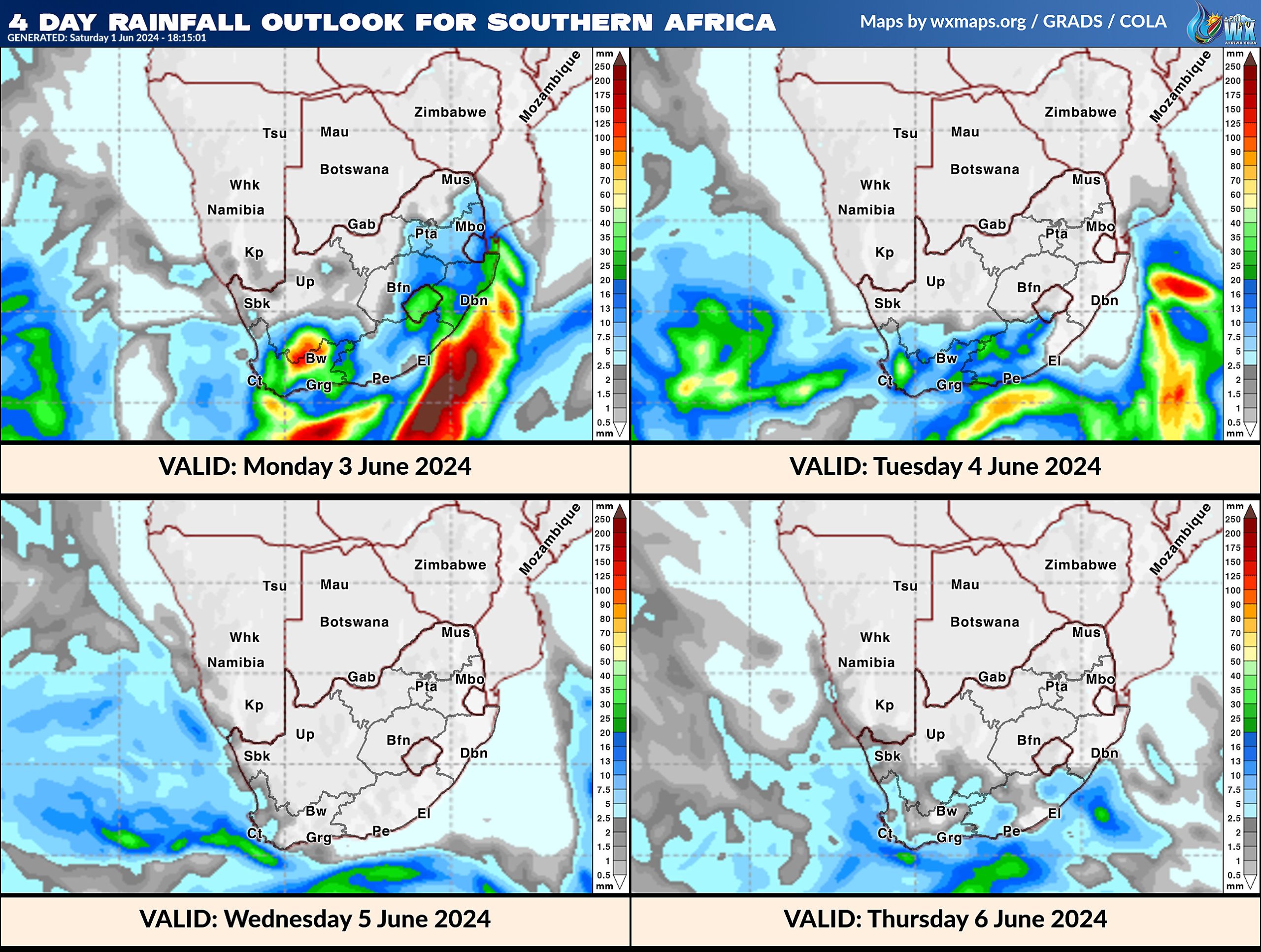
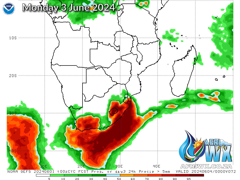
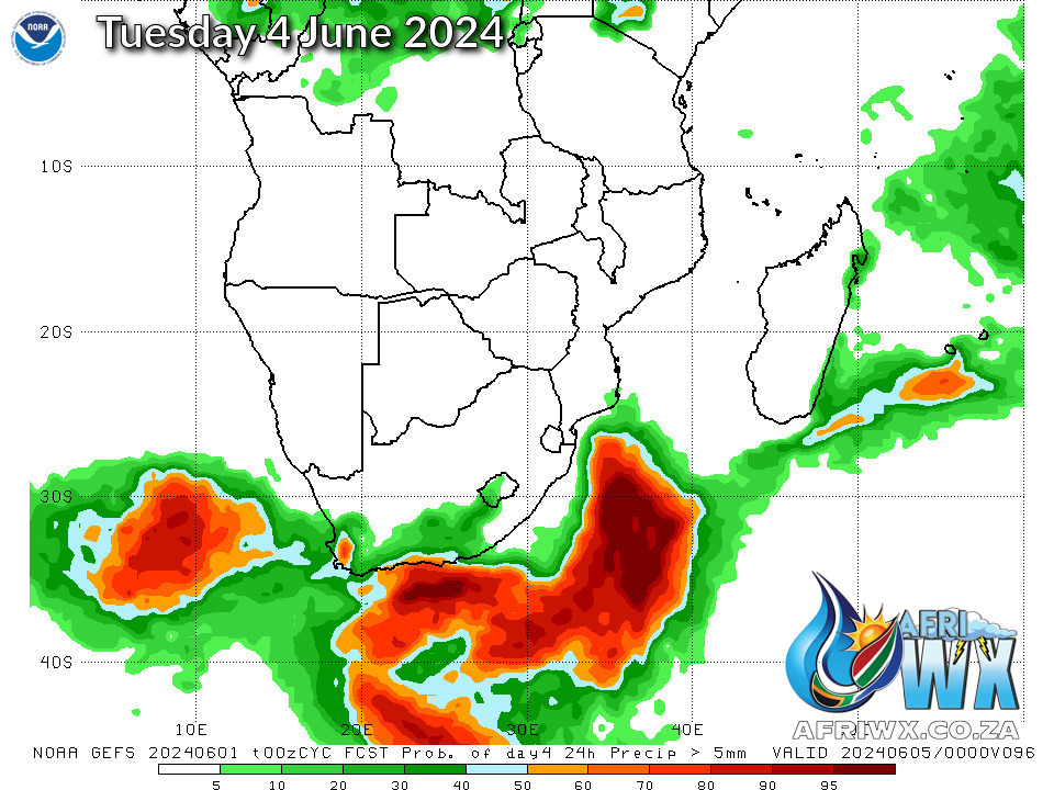
4 Day Rainfall Outlook for Southern Africa
14 Day Rainfall Outlook for Southern Africa
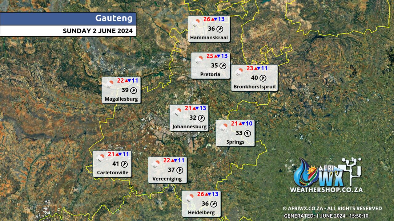
Gauteng Province Weather Map Sunday 2 June 2024
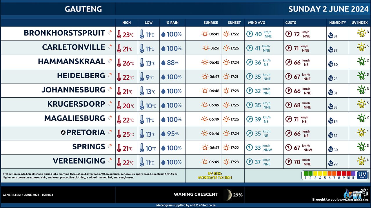
Gauteng Province Weather Meteogram Sunday 2 June 2024
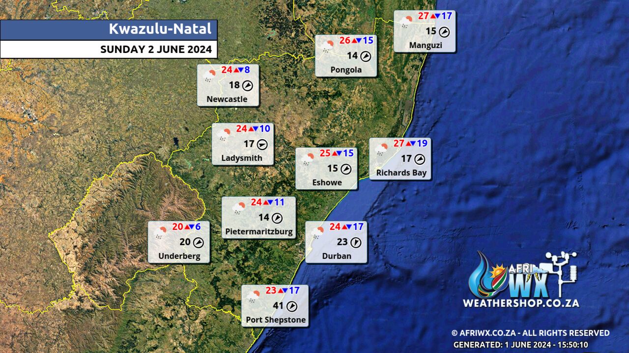
Kwazulu-Natal Province Weather Map Sunday 2 June 2024
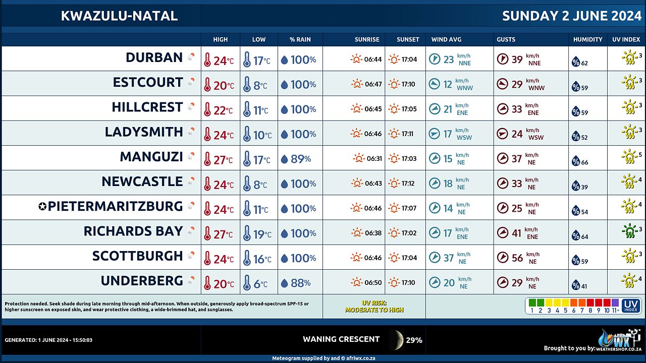
Kwazulu-Natal Province Weather Meteogram Sunday 2 June 2024
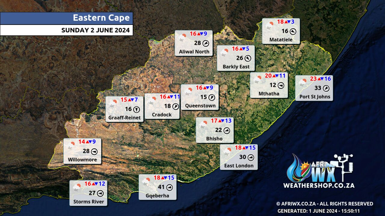
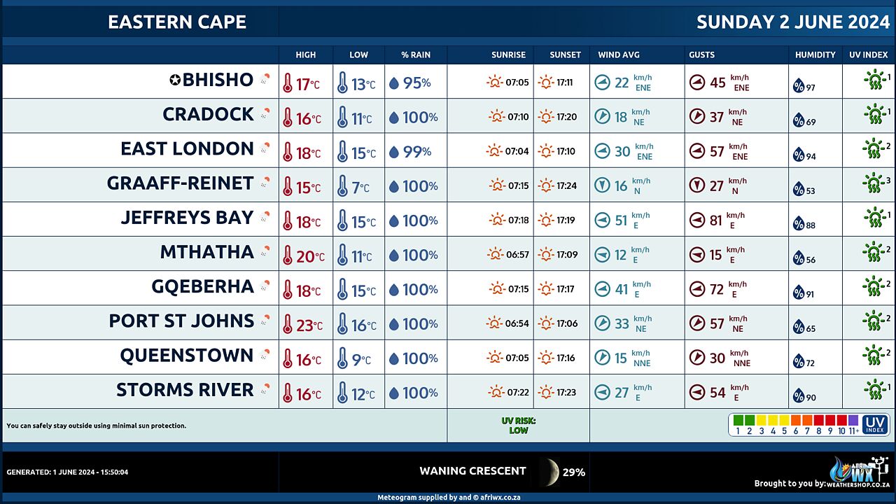
Eastern Cape Province Weather Map Sunday 2 June 2024
Eastern Cape Province Weather Meteogram Sunday 2 June 2024
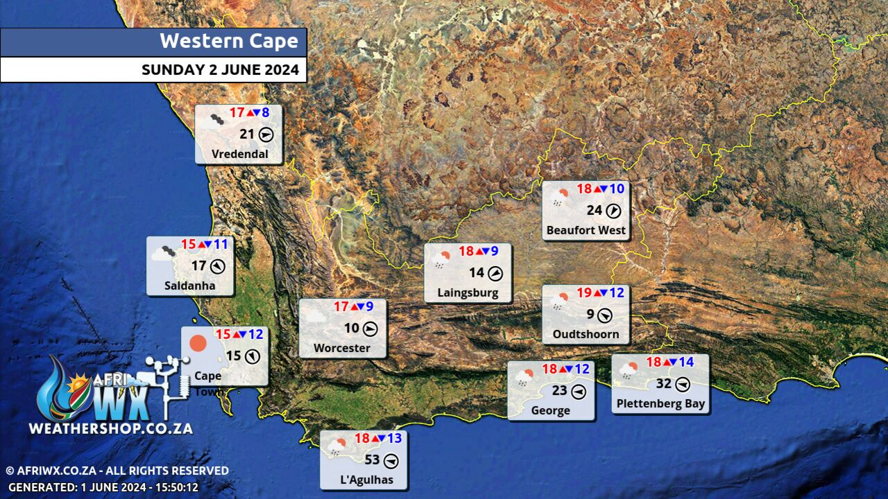
Western Cape Province Weather Map Sunday 2 June 2024
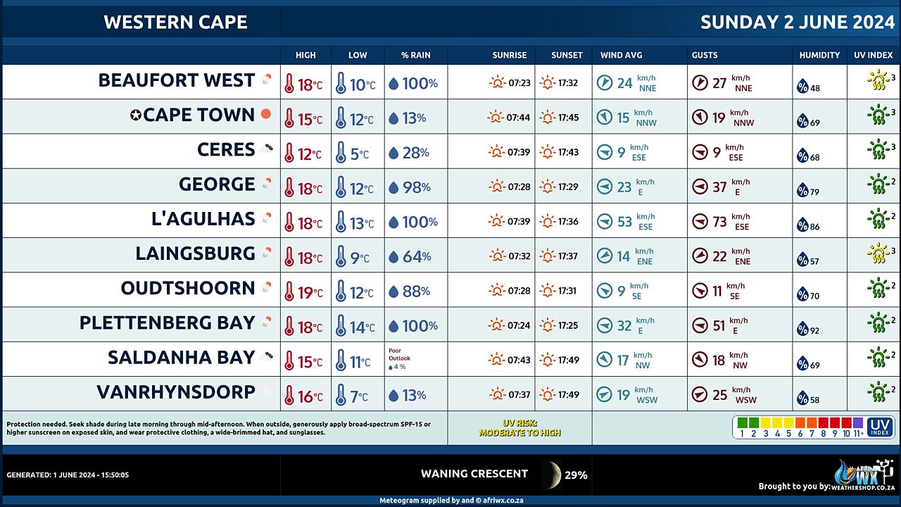
Western Cape Province Weather Meteogram Sunday 2 June 2024
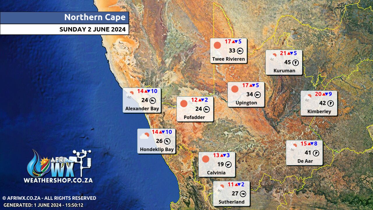
Northern Cape Province Weather Map Sunday 2 June 2024
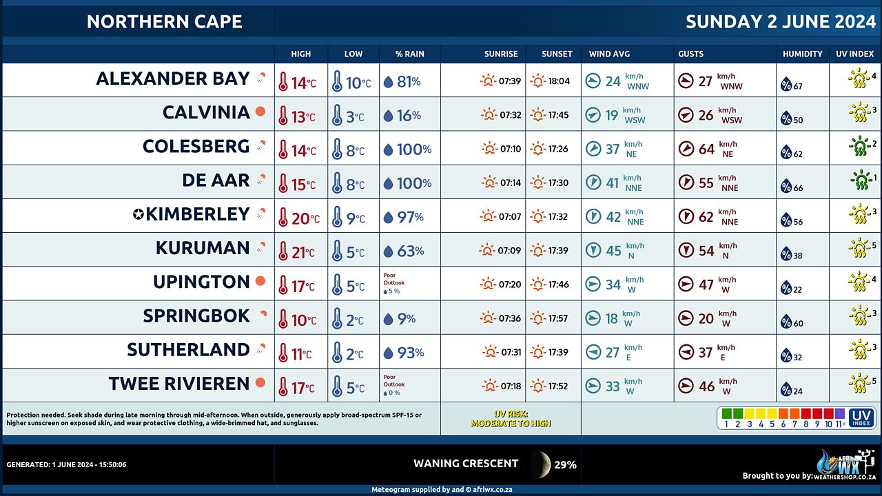
Northern Cape Province Weather Meteogram Sunday 2 June 2024
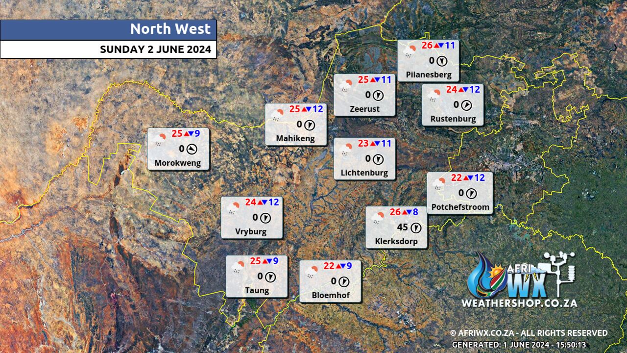
North-West Province Weather Map Sunday 2 June 2024
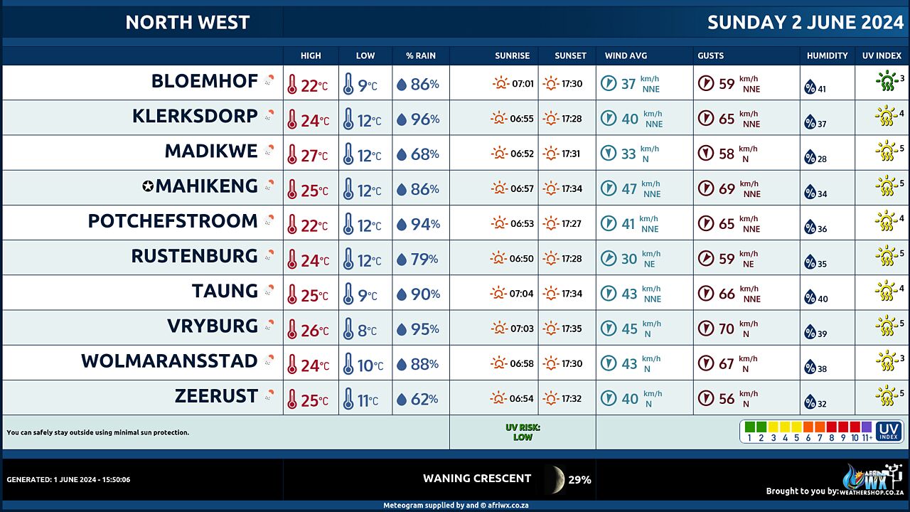
North-West Province Weather Meteogram Sunday 2 June 2024
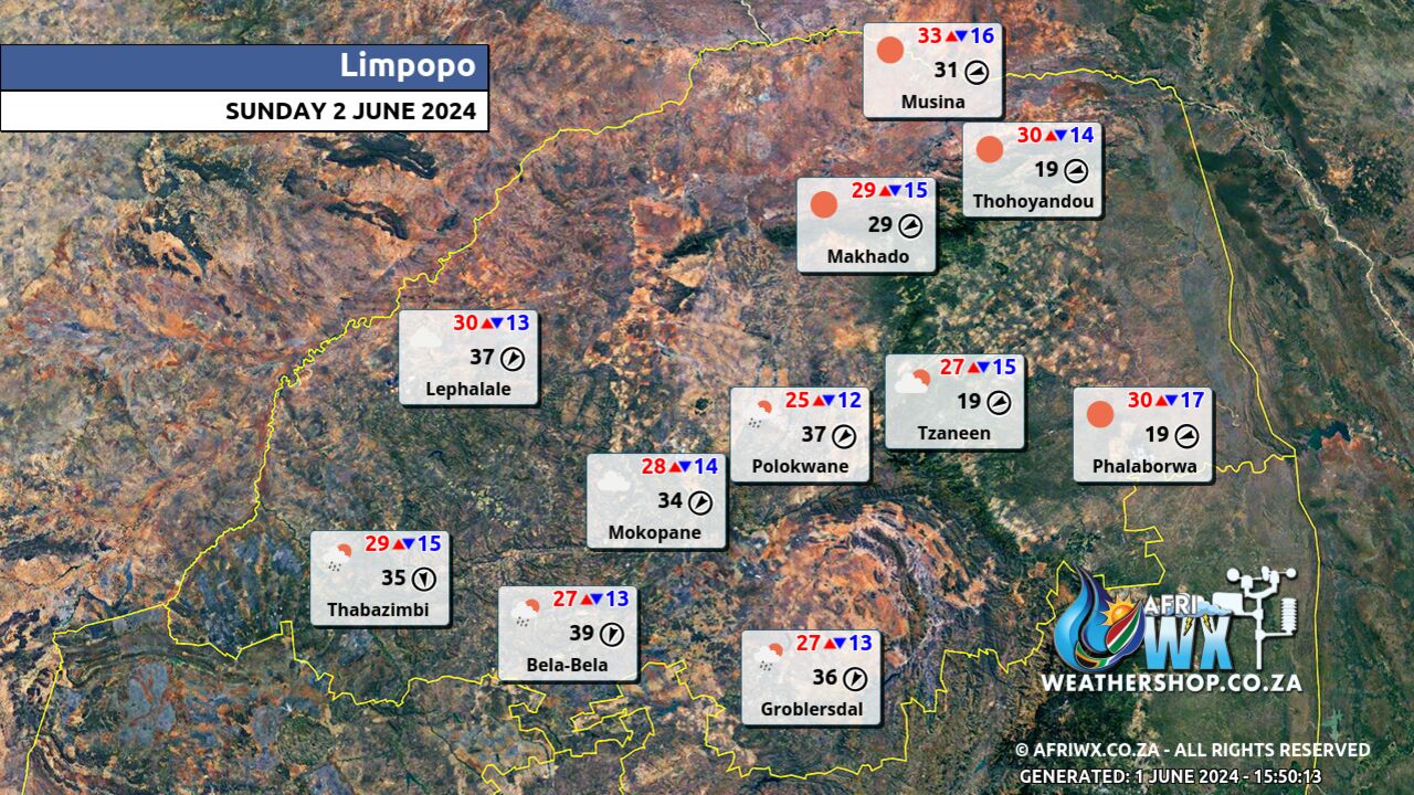
Limpopo Province Weather Map Sunday 2 June 2024
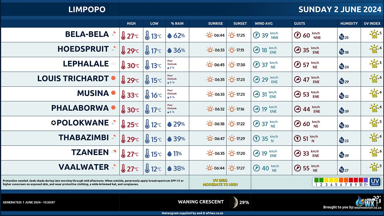
Limpopo Province Weather Meteogram Sunday 2 June 2024
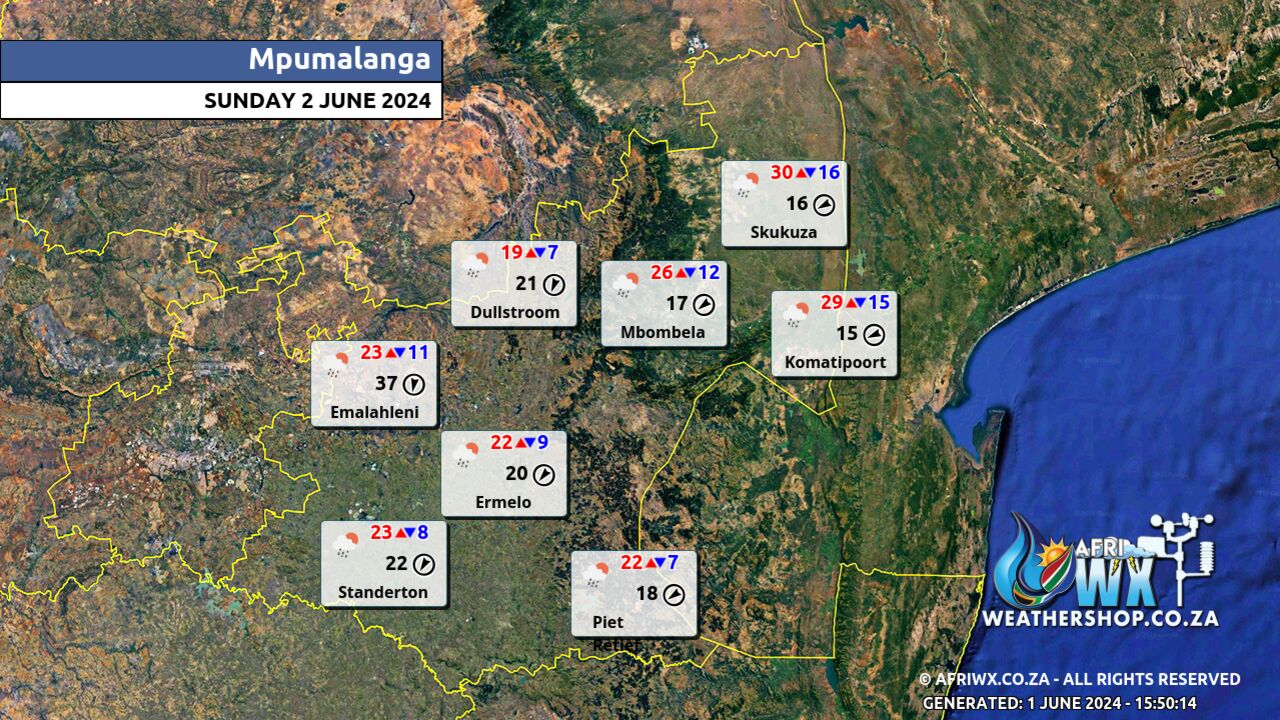
Mpumalanga Province Weather Map Sunday 2 June 2024
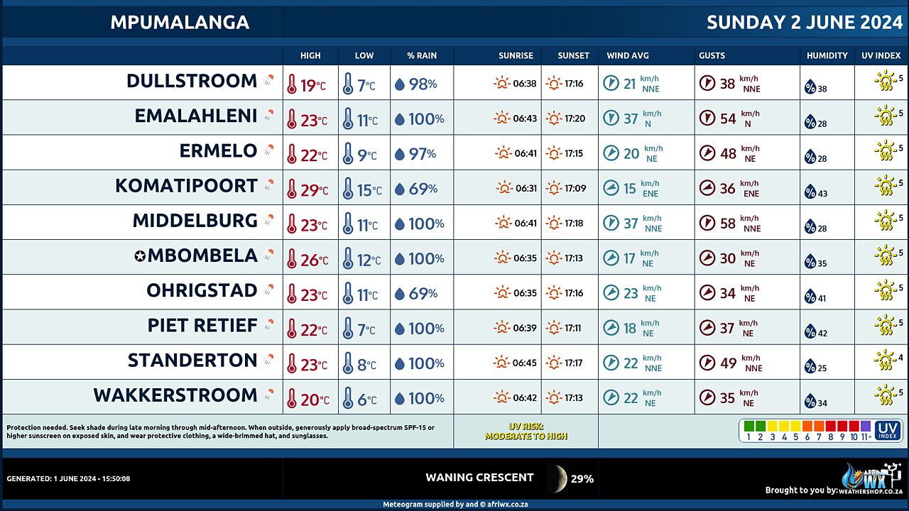
Mpumalanga Province Weather Meteogram Sunday 2 June 2024
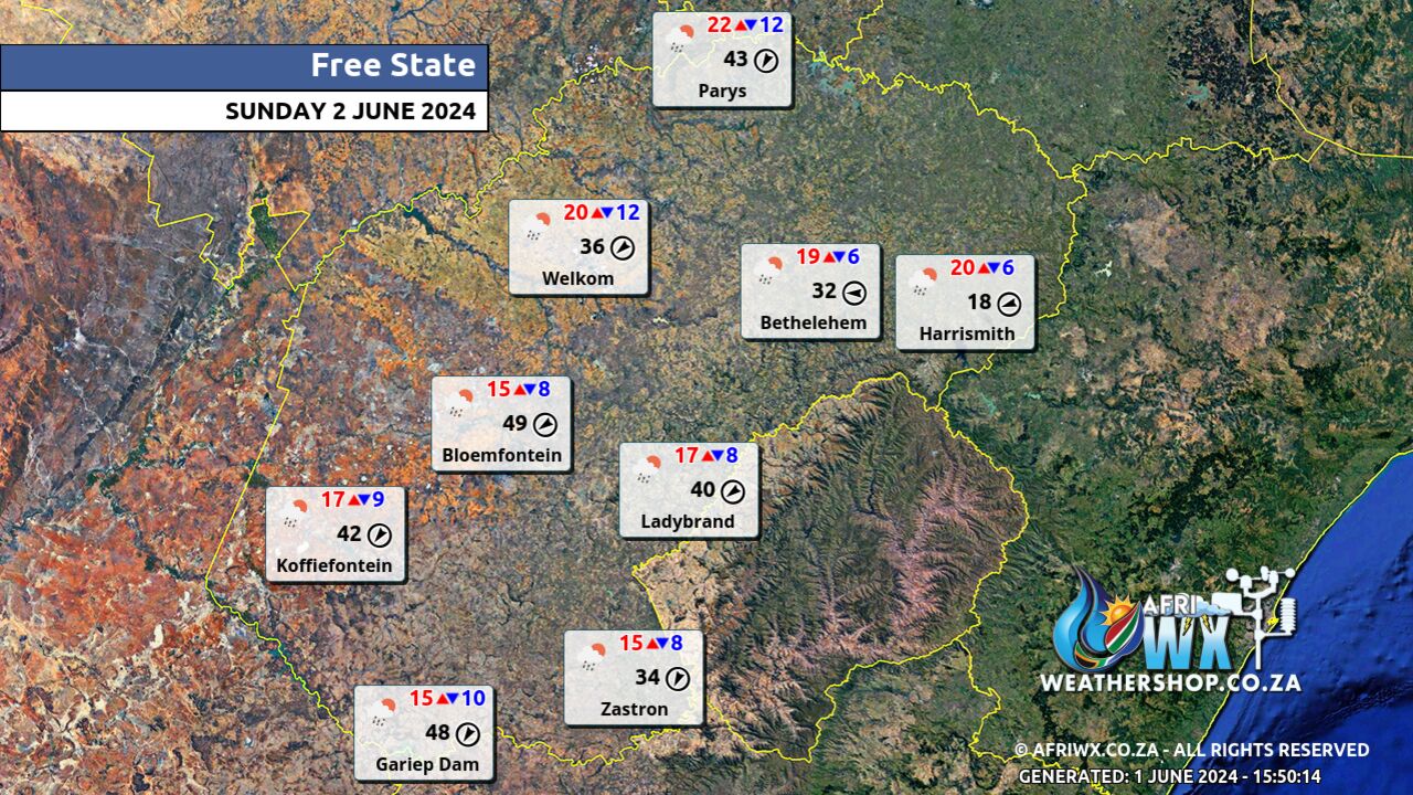
Free State Province Weather Map Sunday 2 June 2024
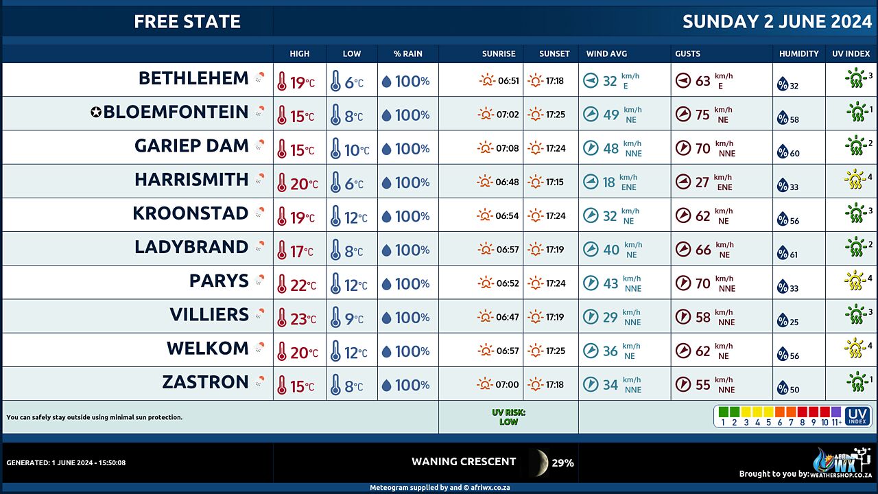
Free State Province Weather Meteogram Sunday 2 June 2024
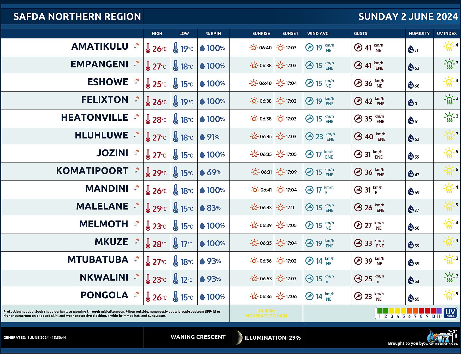
SAFDA Sugar Cane Farming (Northern Kwazulu-Natal) Weather Forecast Sunday 2 June 2024
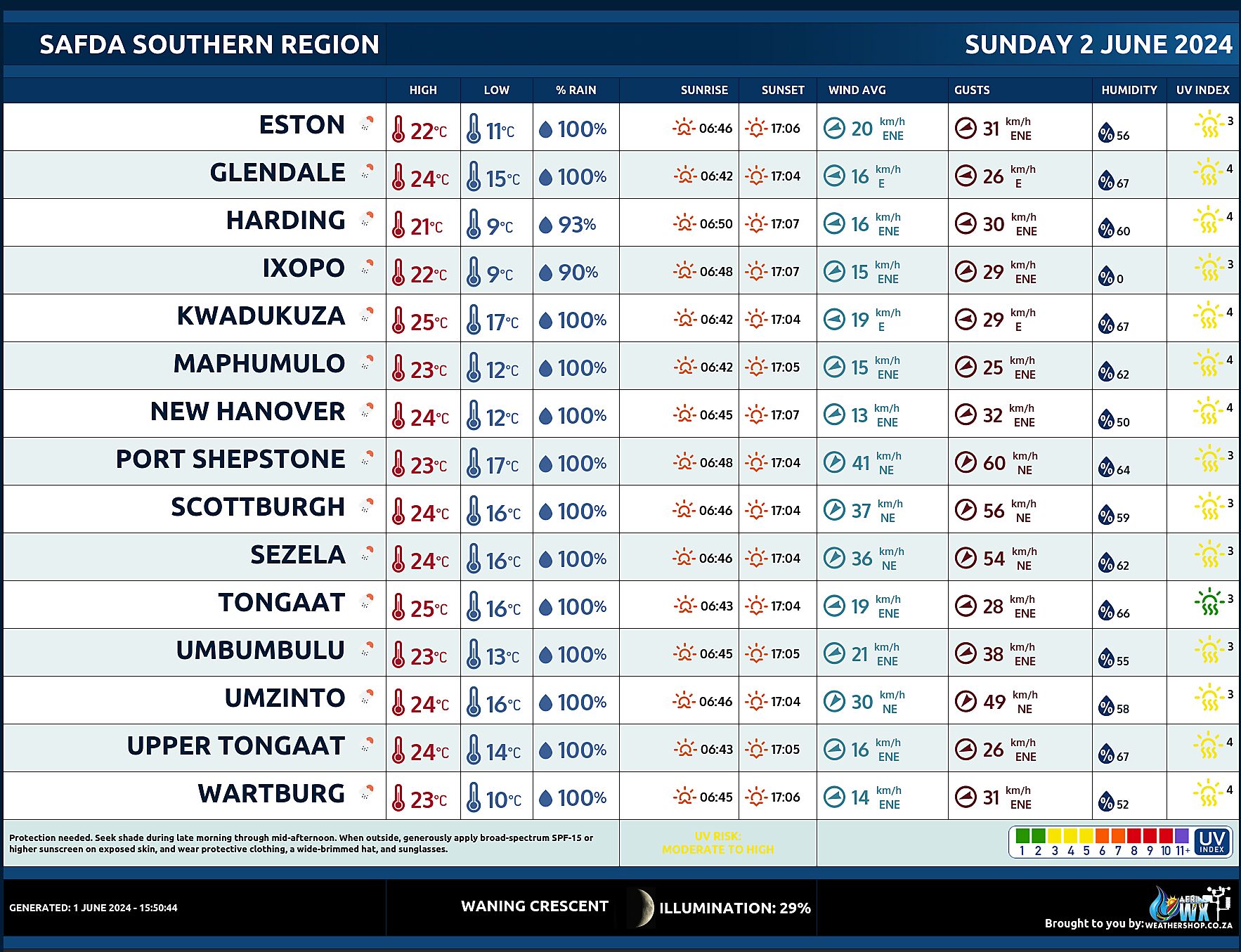
SAFDA Sugar Cane Farming (Southern Kwazulu-Natal) Weather Forecast Sunday 2 June 2024
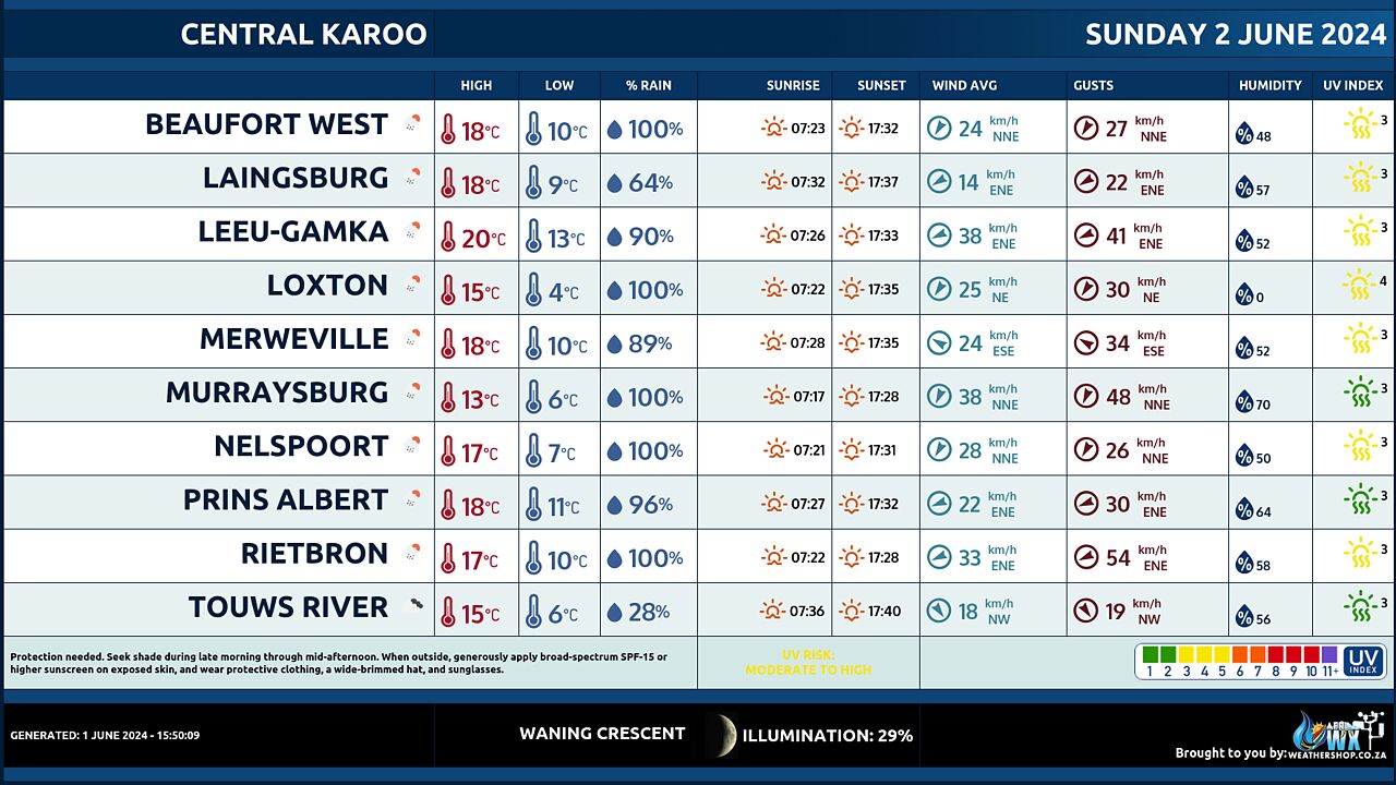
Central Karoo (Northern Cape) Farming Weather Forecast Sunday 2 June 2024
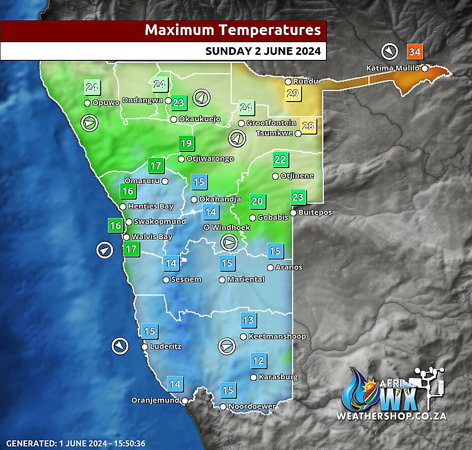
Namibia Maximum Temperatures Sunday 2 June 2024
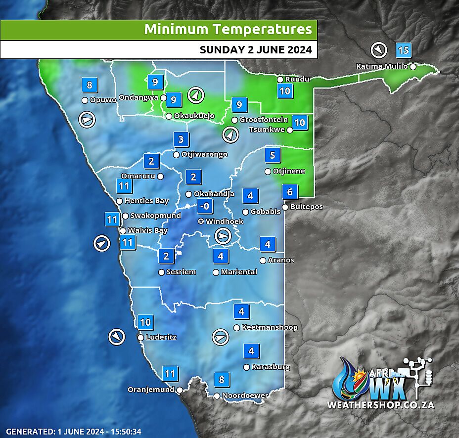
Namibia Minimum Temperatures Sunday 2 June 2024
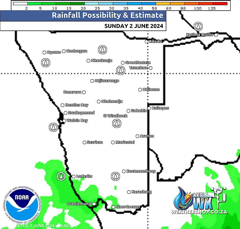
Namibia Rainfall Probability Map Sunday 2 June 2024
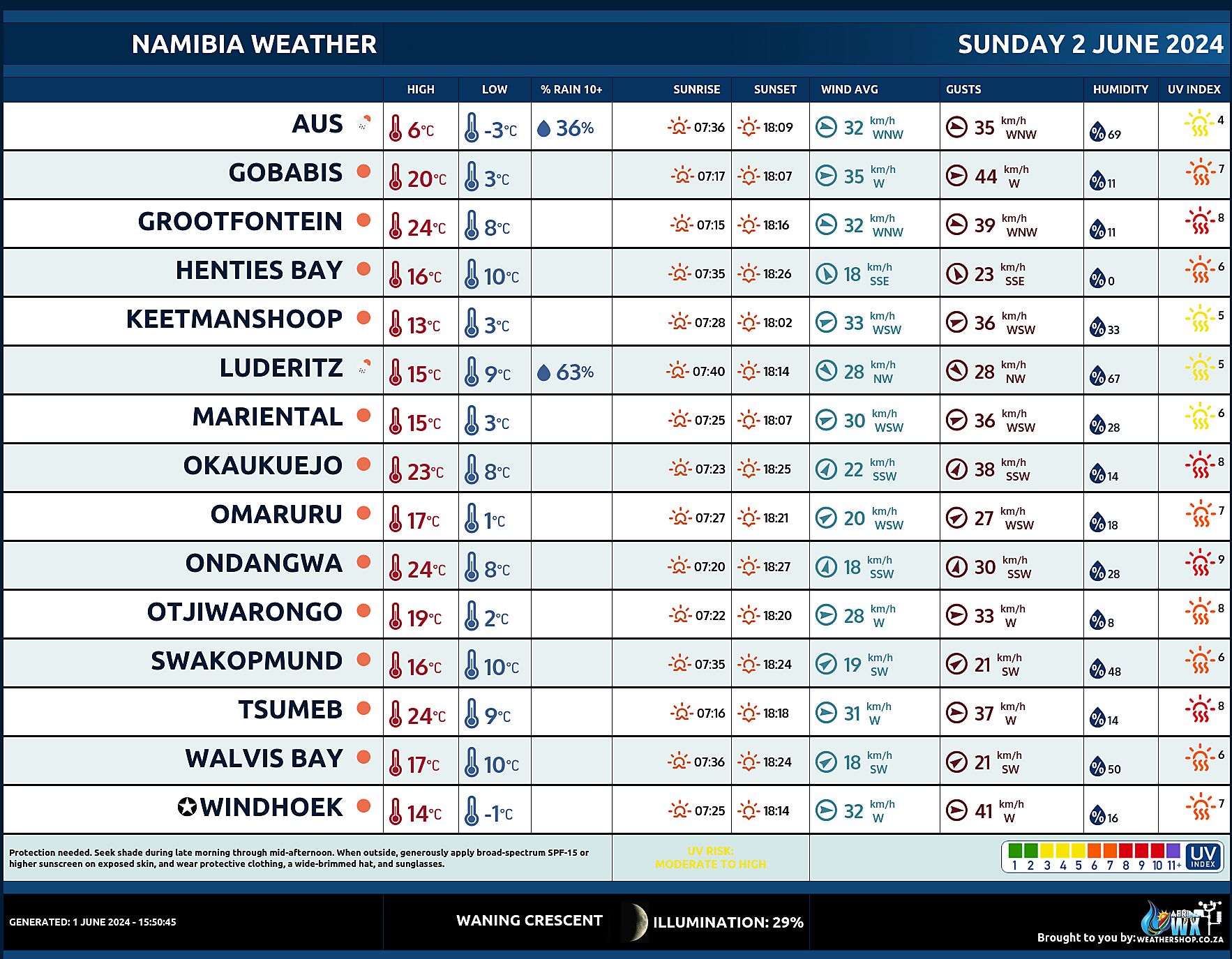
Namibia Weather Meteogram Sunday 2 June 2024
Namibia Meteorological Services METEONA Weather Forecast Sunday 2 June 2024
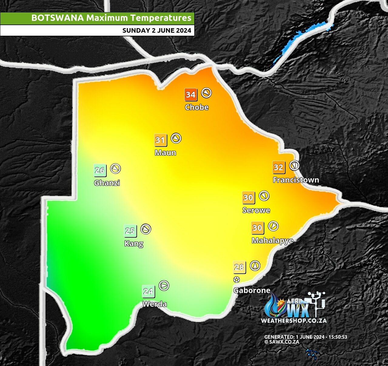
Botswana Maximum Temperatures Sunday 2 June 2024
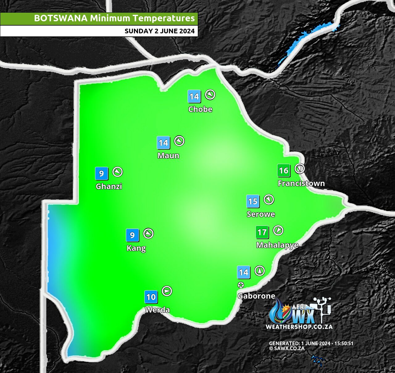
Botswana Minimum Temperatures Sunday 2 June 2024
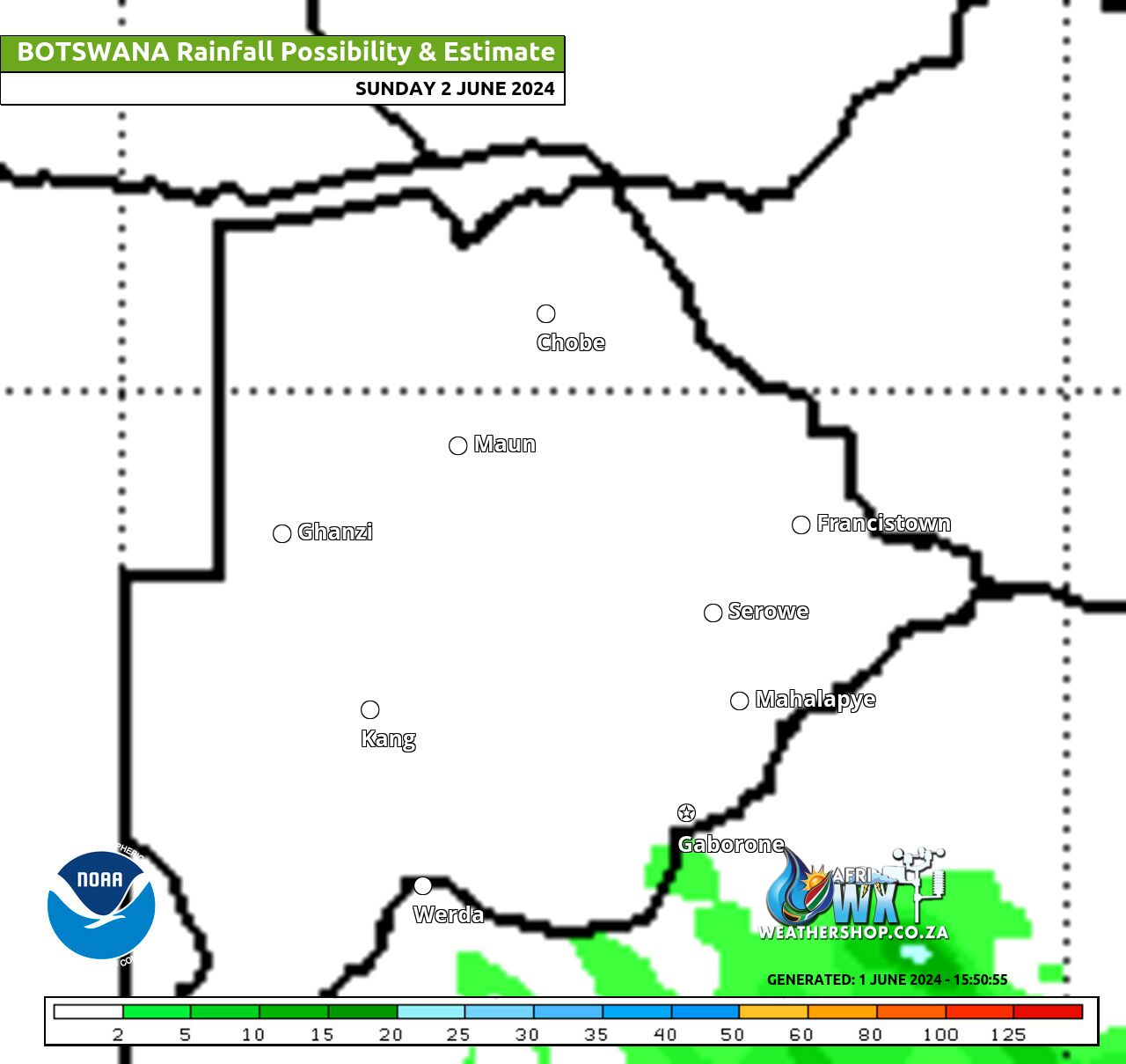
Botswana Rainfall Possibility Map Sunday 2 June 2024
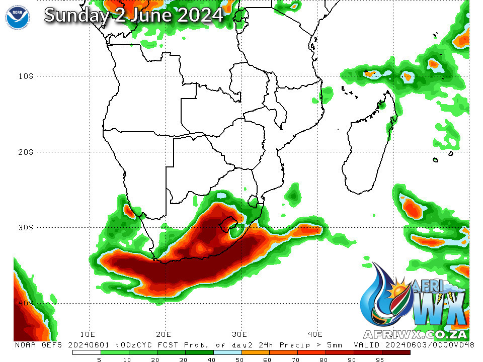
NOAA GEFS Global Ensemble Rainfall Outlook Southern Africa
JOIN OUR FREE AFRIWX WEATHER GROUP on Telegram Messenger
Please download Telegram for Android or iPhone if you want to always be up to date with the latest weather maps.
CLICK HERE TO JOIN our Telegram Group Now


