Last Updated on 27th December 2020 3:49 PM by AfriWX
THE REGIONAL WEATHER FORECAST
FOR TOMORROW 2020-01-22
ISSUED AT 1600 SAST
BY THE SOUTH AFRICAN WEATHER SERVICE.
SEVERE WEATHER ALERTS
WARNINGS
1.
High fire danger conditions are expected over the central and eastern part of Northern Cape, western part of North West and western half of the Free State.
WATCHES
1.
Severe thunderstorms are expected over the eastern interior of the Western Cape, and over the eastern interior of the Eastern Cape.
2.
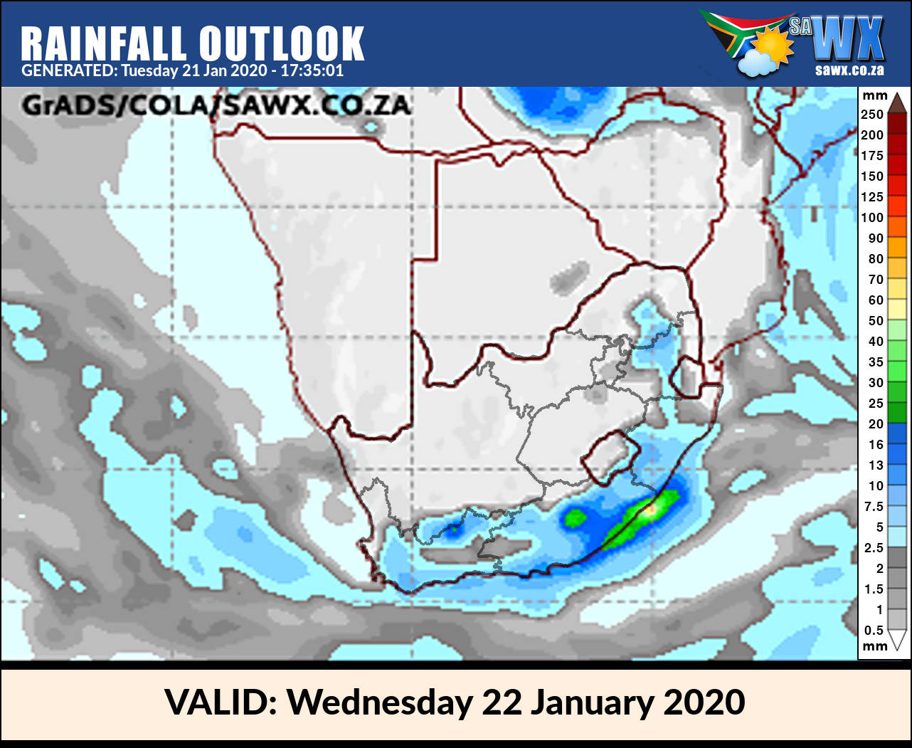
Heavy rain is expected in places along the wild coast and adjacent interior of the Eastern Cape.
SPECIAL WEATHER ADVISORIES
Nil.
PROVINCIAL WEATHER OVERVIEW
GAUTENG PROVINCE
Morning fog patches in the south, otherwise partly cloudy and warm with isolated showers and thundershowers.
The expected UVB sunburn Index Moderate
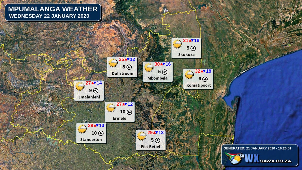
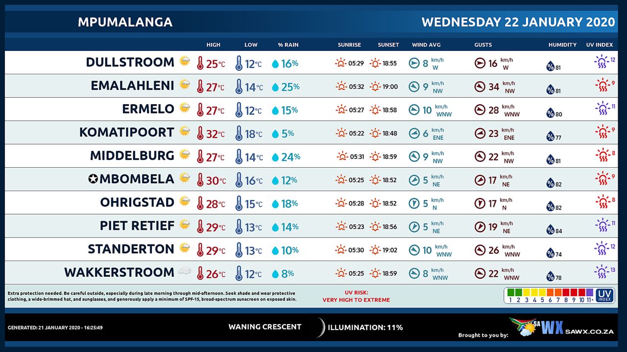
MPUMALANGA PROVINCE
Cloudy with morning fog patches along the escarpment where it will be cool, otherwise partly cloudy and warm with scattered showers and thundershowers but isolated in the Lowveld.
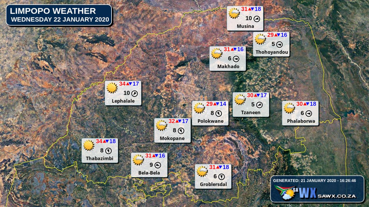
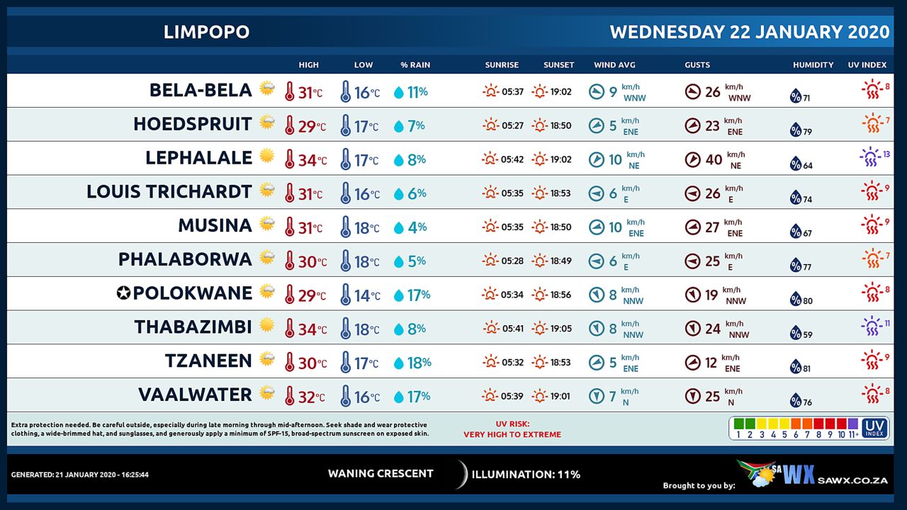
LIMPOPO PROVINCE
Cloudy with morning fog patches in the east, otherwise partly cloudy and warm with isolated showers and thundershowers except in the Limpopo Valley.
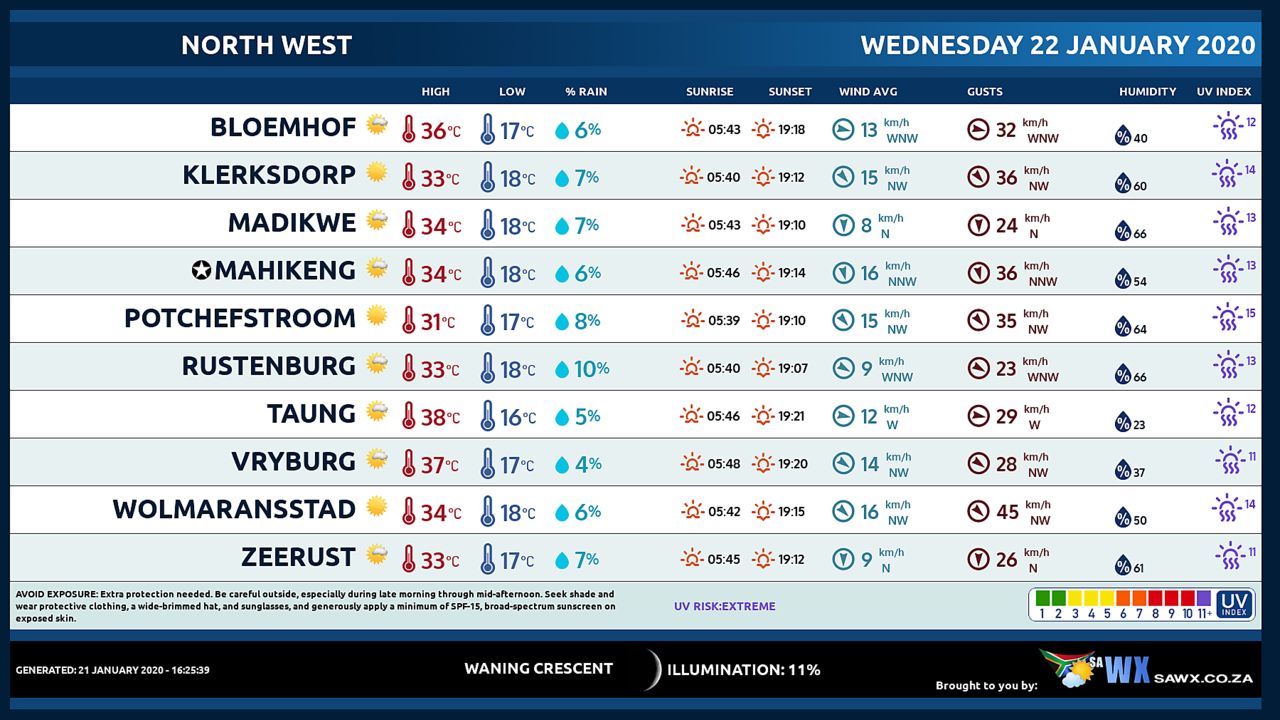
NORTH-WEST PROVINCE
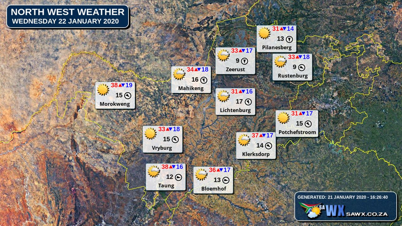
Fine and warm to hot, becoming partly cloudy in the central and eastern parts with isolated showers and thundershowers in the east.
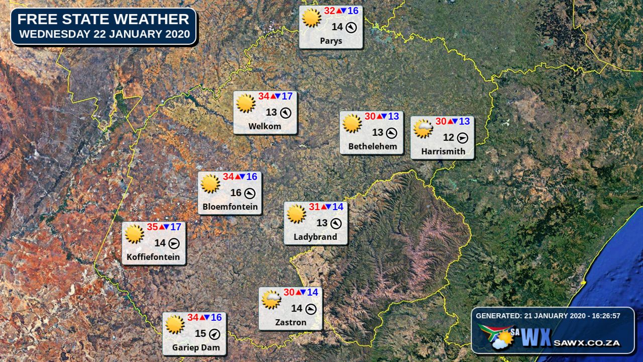
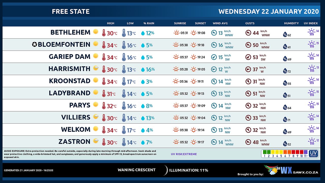
FREE STATE
Morning for patches where it will be cloudy in the east at first, but fine in the south, otherwise partly cloudy and warm to hot.
Isolated showers and thundershowers can be expected in the east.
6.
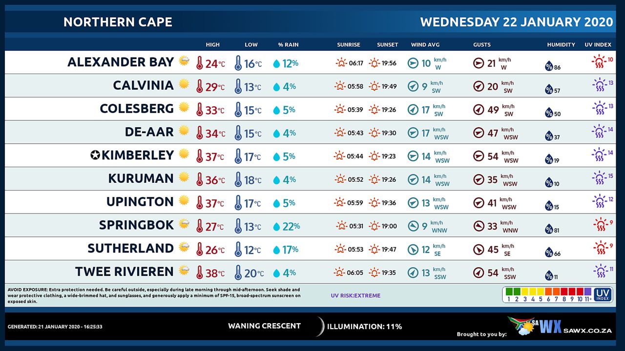
EASTERN PARTS OF THE NORTHERN CAPE Warm in the south, otherwise fine and hot to very hot, but partly cloudy in the north east, spreading to the south by the afternoon, clearing by the evening.
6.
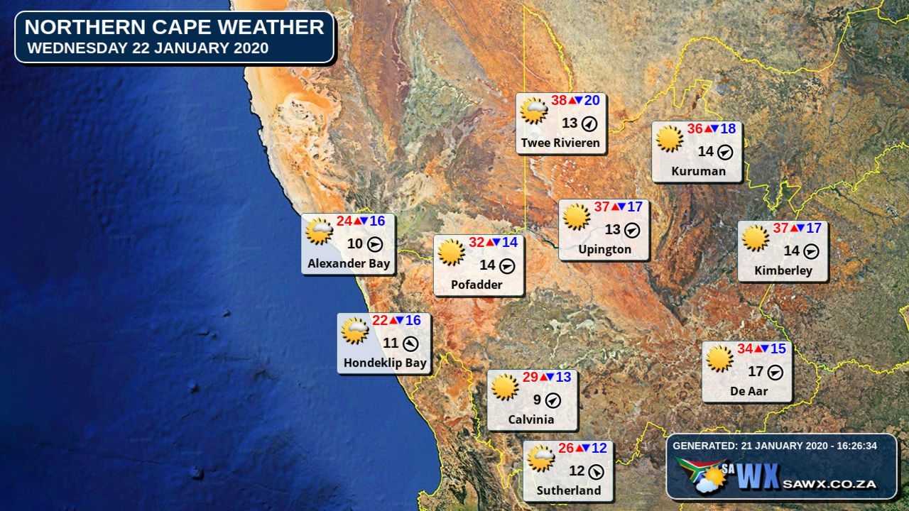
WESTERN PARTS OF THE NORTHERN CAPE Fog patches along the coast at first, otherwise partly cloudy to cloudy and warm clearing in the west during the afternoon.
Rain showers are expected in the south during the afternoon.
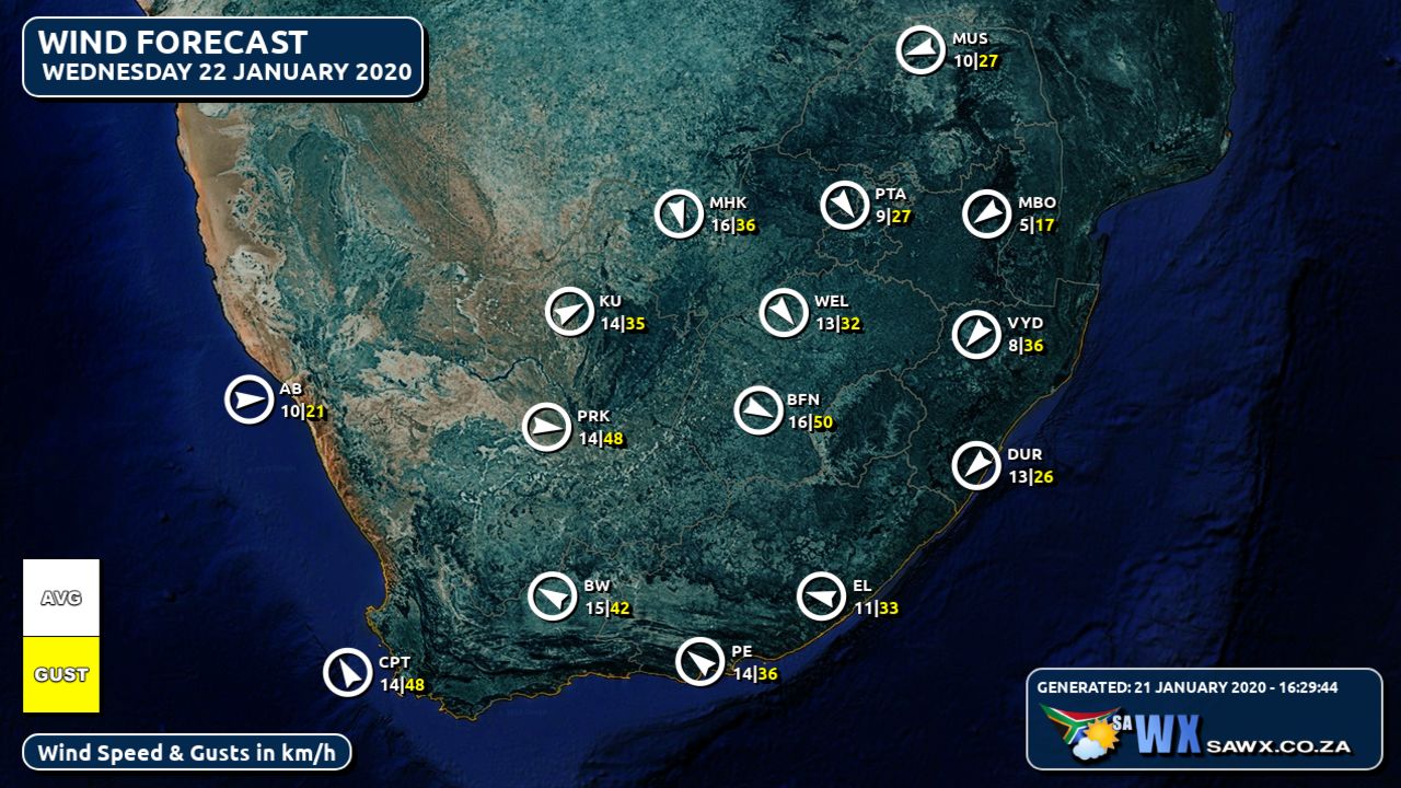
The wind along the coast will be light to moderate north-westerly becoming south-westerly by evening.
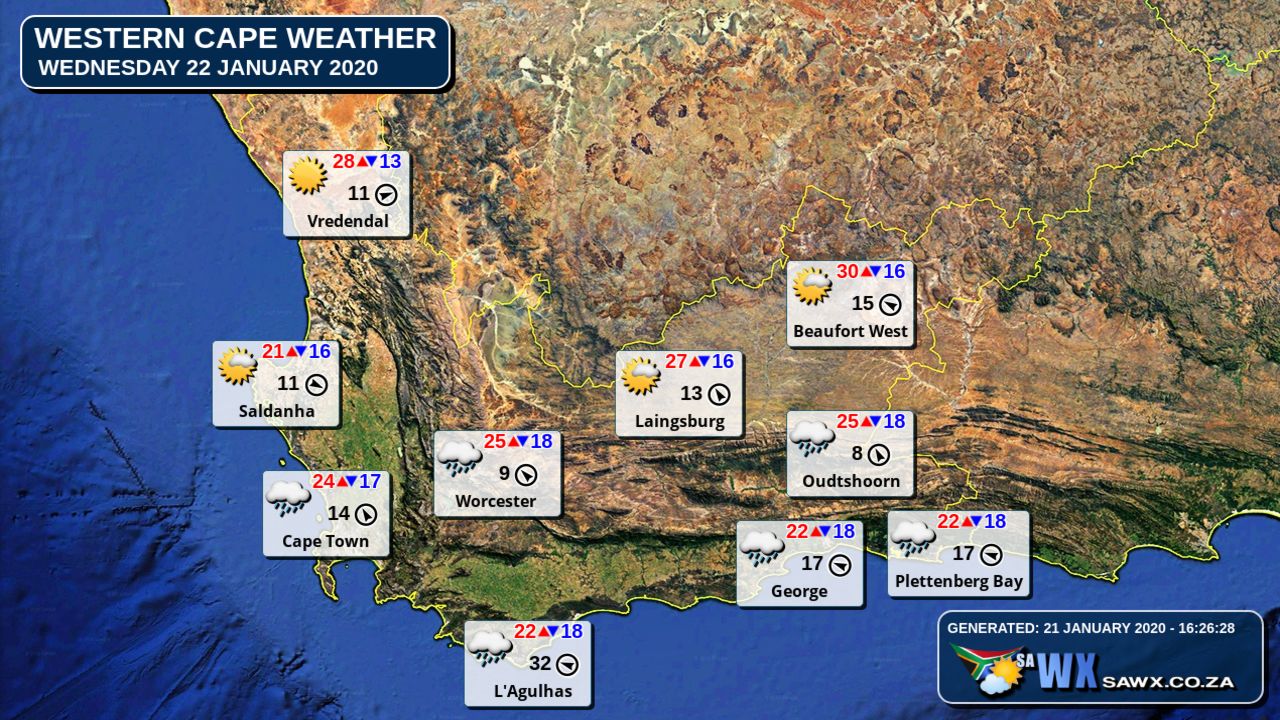
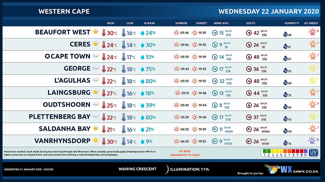
WESTERN CAPE
Fog patches along the west coast at first, otherwise cloudy and cool to warm with isolated showers and thundershowers from the afternoon except in the extreme west.
The wind along the coast will be fresh to strong south-easterly but light to moderate north-westerly to westerly along the west coast.
The expected UVB sunburn Index High
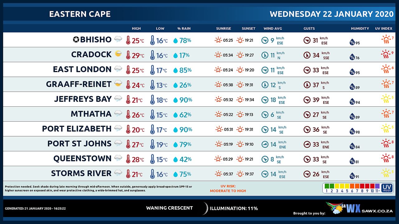
WESTERN HALF OF THE EASTERN CAPE
Partly cloudy and warm in the north, otherwise cloudy and cool with scattered showers and thundershowers, but isolated over the extreme south west.
The wind along the coast will be Moderate to fresh south easterly.
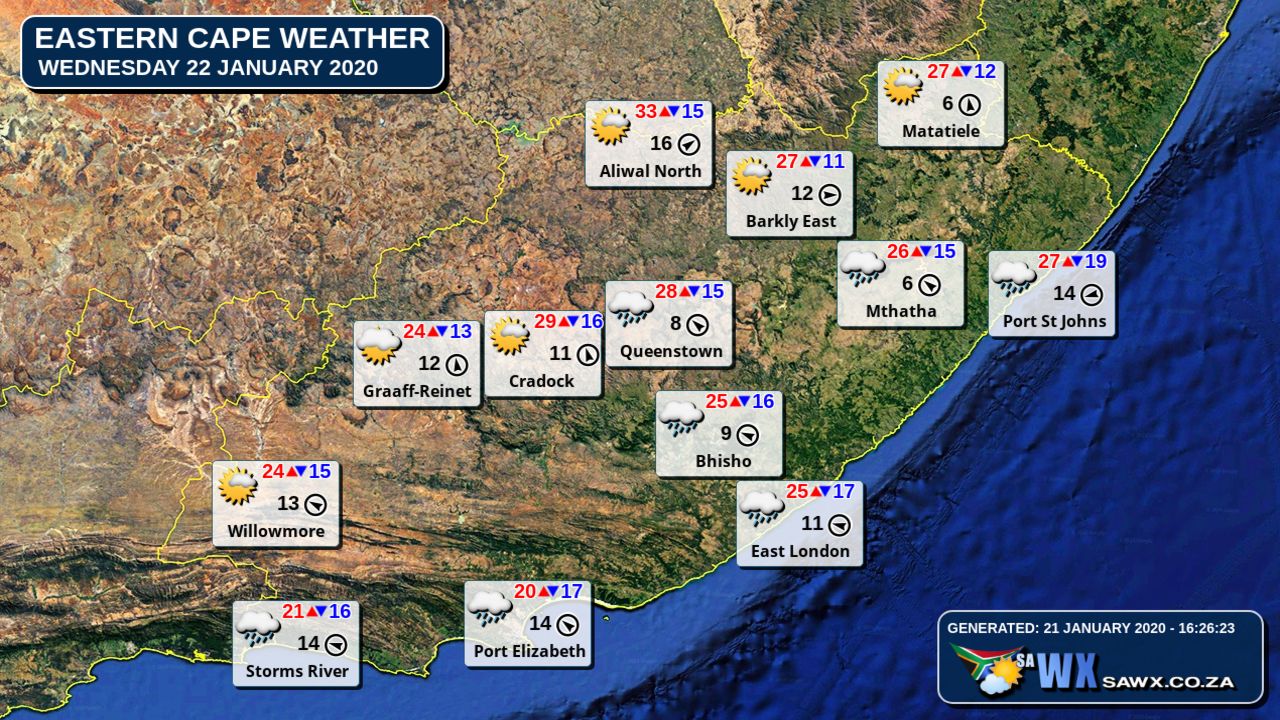
EASTERN HALF OF THE EASTERN CAPE
Partly cloudy in the north and warm in the east, otherwise cloudy with scattered showers and thundershowers, but widespread along the wild coast.
The wind along the coast will be Light north-easterly at first, otherwise moderate to fresh easterly.
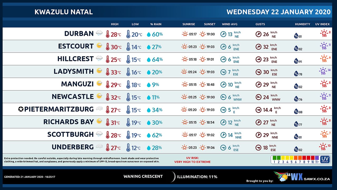
KWAZULU-NATAL
Partly cloudy and warm, becoming cloudy in the afternoon with scattered showers and thundershowers, but isolated in the north-east.
The wind along the coast will be Gentle north-westerly north of St Lucia at first, otherwise moderate to fresh northerly to north-easterly.
The expected UVB sunburn Index Moderate
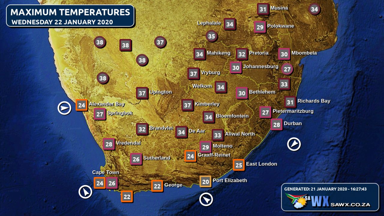
Maximum Temperatures Forecast for South Africa Wednesday 22 January 2020
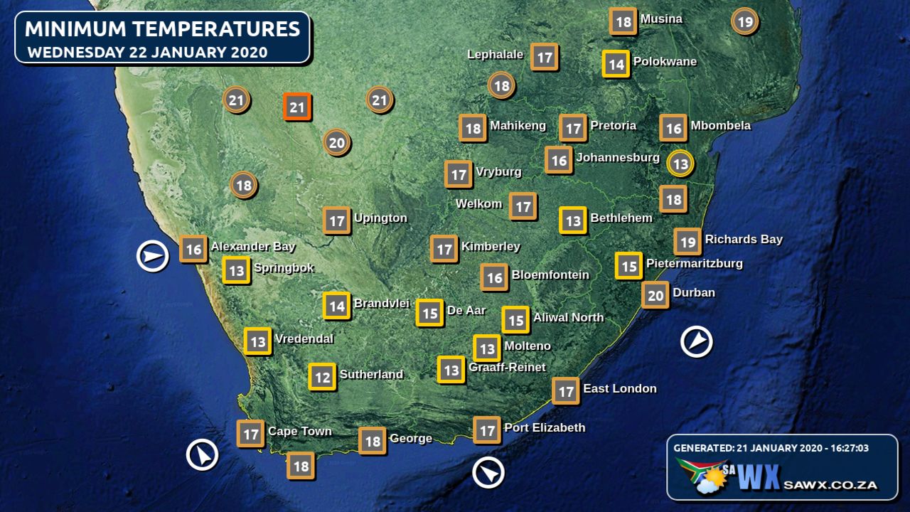
Minimum Temperatures Forecast for South Africa Wednesday 22 January 2020
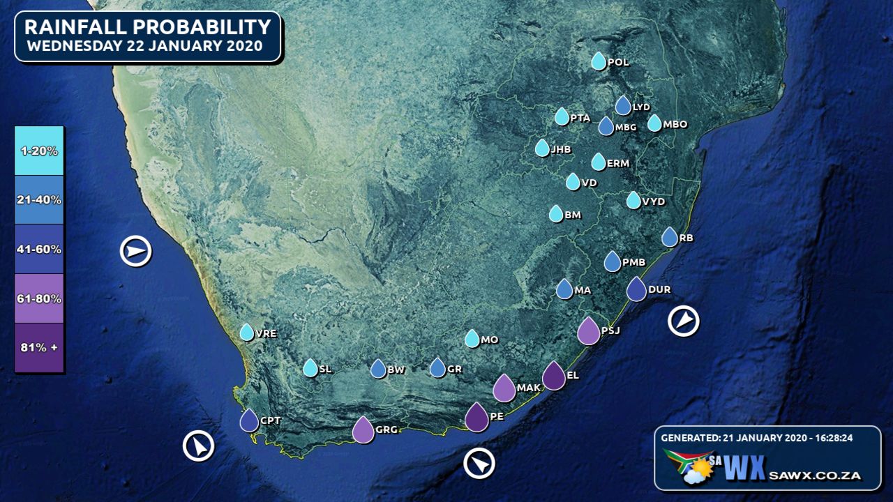
Rainfall Outlook for South Africa Wednesday 22 January 2020
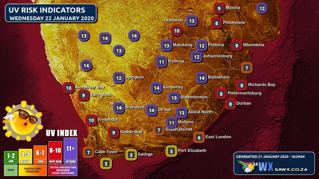
UVB Index Outlook for South Africa Wednesday 22 January 2020
Wind Speed Direction and Gusts Map for South Africa Wednesday 22 January 2020
TRAVELLERS WEATHER FORECAST
FOR TOMORROW 2020-01-22
ISSUED AT 1530 SAST
BY THE SOUTH AFRICAN WEATHER SERVICE.
SEVERE WEATHER ALERTS
WARNINGS
1.
High fire danger conditions are expected over the central and eastern part of Northern Cape, western part of North West and western half of the Free State.
WATCHES
1.
Severe thunderstorms are expected over the eastern interior of the Western Cape, and over the eastern interior of the Eastern Cape.
2.
Heavy rain is expected in places along the wild coast and adjacent interior of the Eastern Cape.
SPECIAL WEATHER ADVISORIES
Nil.
WEATHER IN OUR TOP CITIES
PRETORIA
Partly cloudy with isolated showers and thundershowers.
Minimum/Maximum 17/27 The expected UVB Sunburn Index Moderate
JOHANNESBURG
Morning fog patches, otherwise partly cloudy with isolated showers and thundershowers.
Minimum/Maximum 15/26
VEREENIGING
– Morning fog patches, otherwise partly cloudy with isolated showers and thundershowers.
Minimum/Maximum 16/27
MBOMBELA
Cloudy with morning fog patches, otherwise partly cloudy with scattered afternoon thundershowers.
Minimum/Maximum 17/25
POLOKWANE
– Cloudy at first, otherwise partly cloudy with isolated afternoon thundershowers.
Minimum/Maximum 17/27
MAHIKENG
Fine becoming partly cloudy with isolated thundershowers.
Minimum/Maximum 18/31
VRYBURG
Fine.
Minimum/Maximum 16/34
BLOEMFONTEIN
Fine becoming partly cloudy in the afternoon.
Minimum/Maximum 14/28
KIMBERLEY
– Fine.
Minimum/Maximum 15/33
UPINGTON
Fine.
Minimum/Maximum 18/35
CAPE TOWN
– Cloudy with afternoon isolated showers and thundershowers.
Wind Moderate to fresh south-easterly.
Minimum/Maximum 18/24 The expected UVB Sunburn Index High
GEORGE
Cloudy with scattered showers and thundershowers.
Wind Fresh to strong easterly to south-easterly.
Minimum/Maximum 15/20
PORT ELIZABETH
– Cloudy with scattered showers.
Wind Moderate to fresh south easterly.
Minimum/Maximum 19/21
EAST LONDON
– Cloudy with widespread showers and rain.
Wind Light north easterly at first, otherwise moderate to fresh easterly.
Minimum/Maximum 19/24
DURBAN
Partly cloudy, becoming cloudy in the afternoon with scattered showers and thundershowers.
Wind moderate easterly to north-easterly.
Minimum/Maximum 19/27 The expected UVB Sunburn Index Moderate
RICHARDS BAY
Partly cloudy with isolated afternoon shower and thundershowers.
Wind moderate to fresh easterly to north-easterly.
Minimum/Maximum 19/28
PIETERMARITZBURG
Morning mist, otherwise cloudy with scattered afternoon showers and thundershowers.
Minimum/Maximum 15/24
Rainfall Outlook for Tomorrow Wednesday 22 January 2020
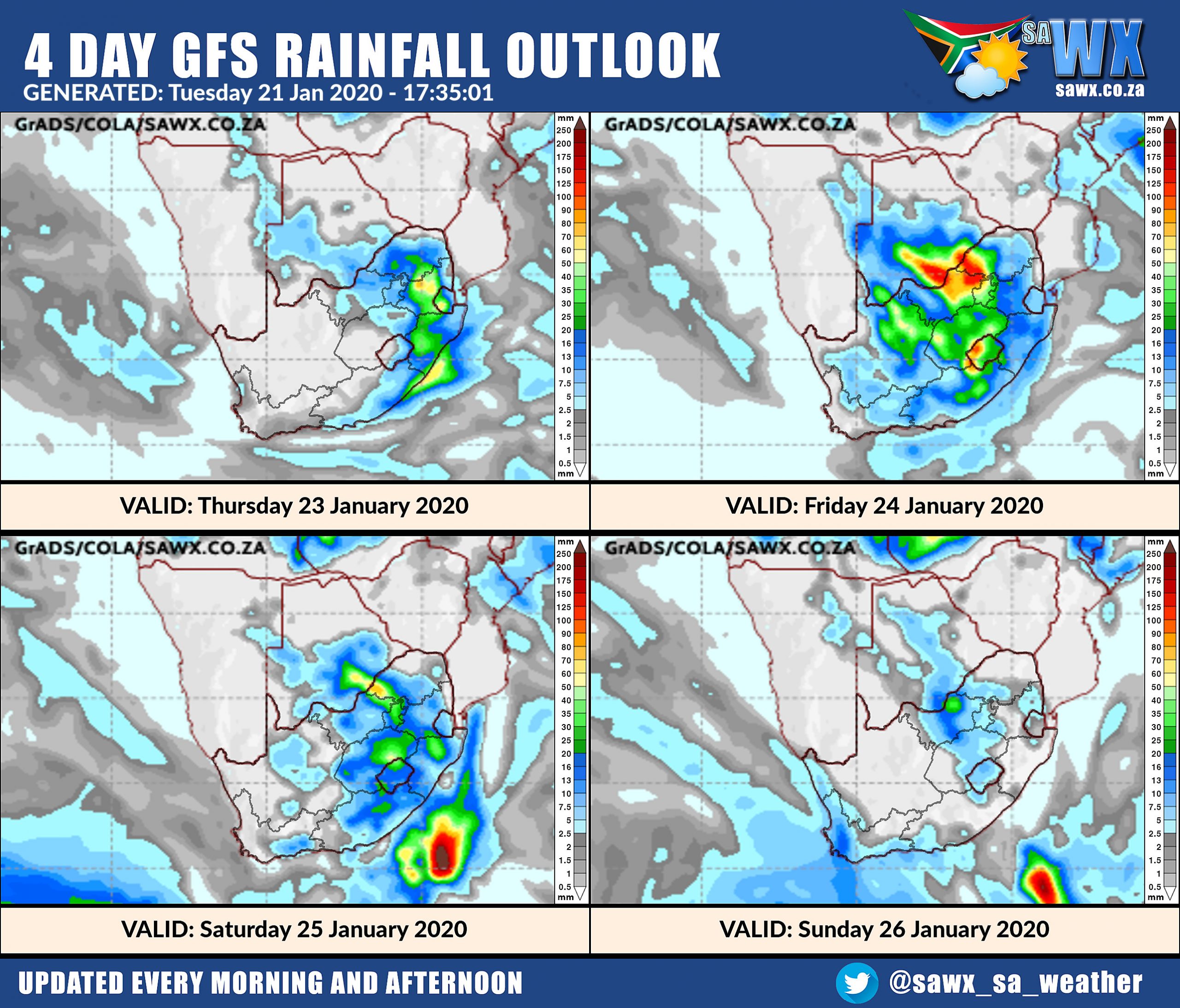
4 Day Rainfall Outlook for Southern Africa
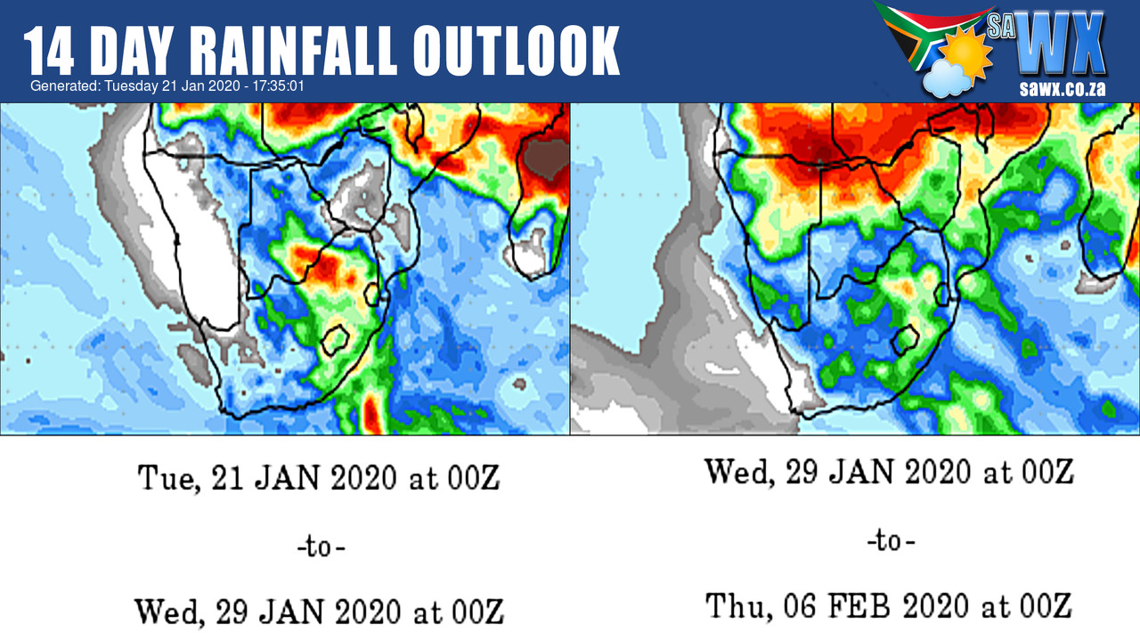
14 Day Rainfall Outlook for Southern Africa
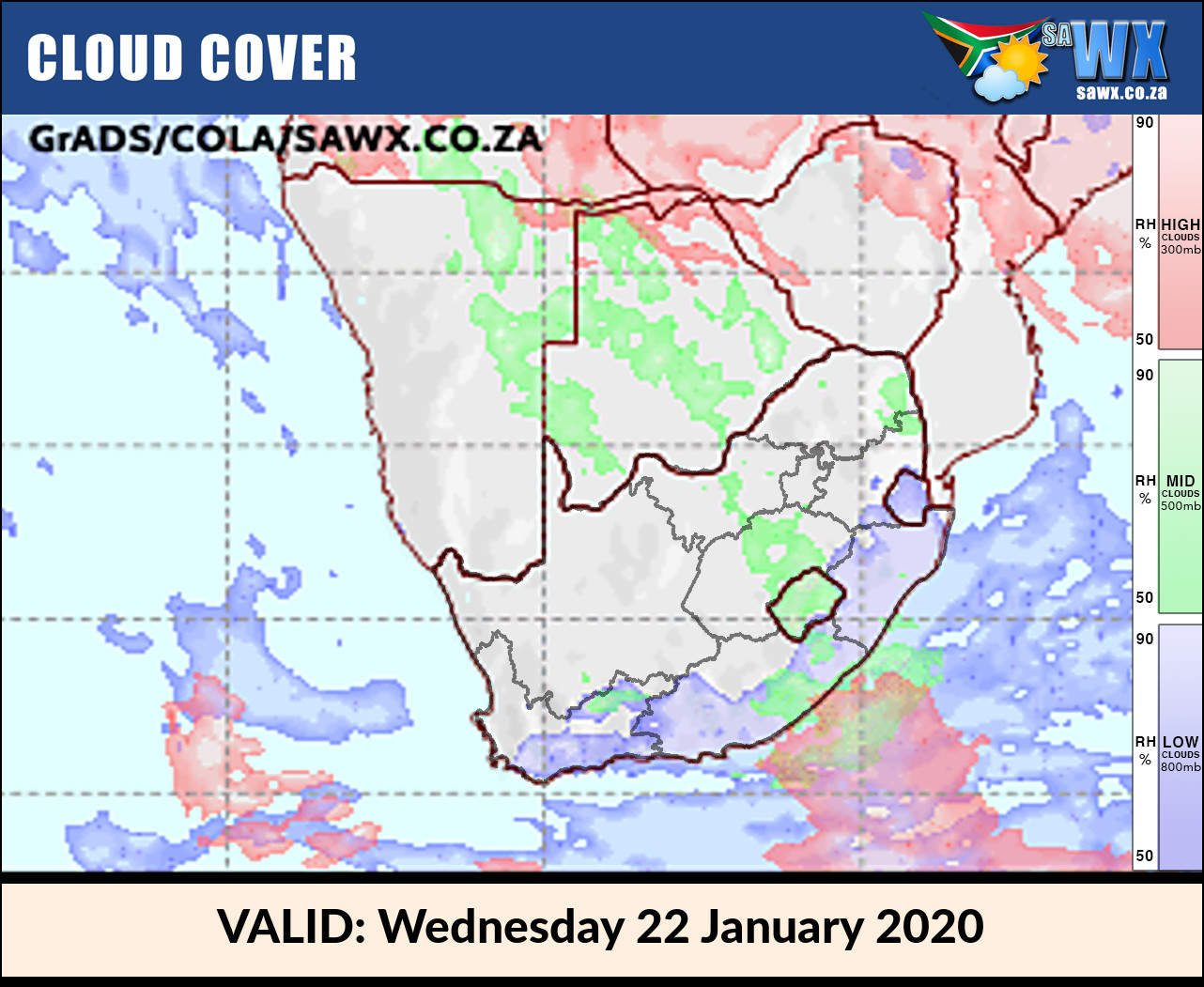
Cloud Cover Outlook for Tomorrow Wednesday 22 January 2020
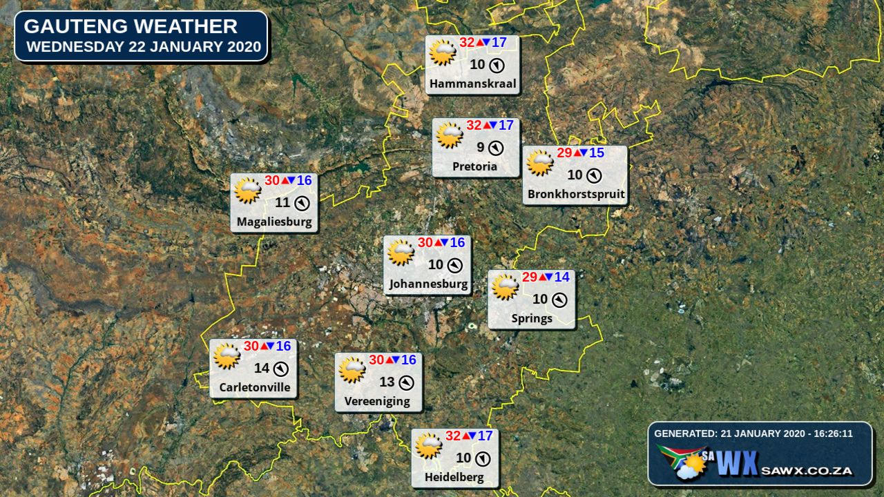
Gauteng Province Weather Map Wednesday 22 January 2020
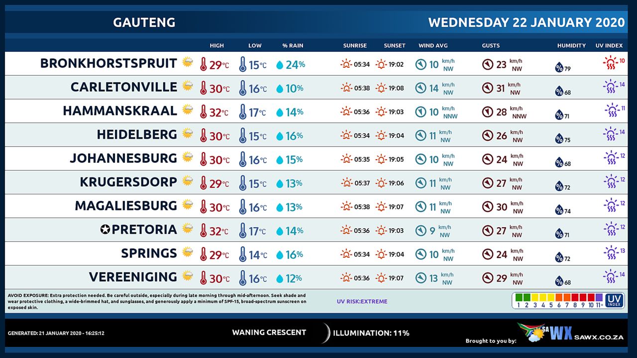
Gauteng Province Weather Meteogram Wednesday 22 January 2020
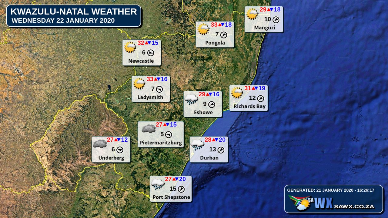
Kwazulu-Natal Province Weather Map Wednesday 22 January 2020
Kwazulu-Natal Province Weather Meteogram Wednesday 22 January 2020
Eastern Cape Province Weather Map Wednesday 22 January 2020
Eastern Cape Province Weather Meteogram Wednesday 22 January 2020
Western Cape Province Weather Map Wednesday 22 January 2020
Western Cape Province Weather Meteogram Wednesday 22 January 2020
Northern Cape Province Weather Map Wednesday 22 January 2020
Northern Cape Province Weather Meteogram Wednesday 22 January 2020
North-West Province Weather Map Wednesday 22 January 2020
North-West Province Weather Meteogram Wednesday 22 January 2020
Limpopo Province Weather Map Wednesday 22 January 2020
Limpopo Province Weather Meteogram Wednesday 22 January 2020
Mpumalanga Province Weather Map Wednesday 22 January 2020
Mpumalanga Province Weather Meteogram Wednesday 22 January 2020
Free State Province Weather Map Wednesday 22 January 2020
Free State Province Weather Meteogram Wednesday 22 January 2020
Weather Maps by SAWX – Feel Free to Share


