Last Updated on 27th December 2020 3:37 PM by AfriWX
THE REGIONAL WEATHER FORECAST
FOR TOMORROW 2020-09-14
ISSUED AT 1600 SAST
BY THE SOUTH AFRICAN WEATHER SERVICE. THIS FORECAST WILL BE UPDATED AT 0500 SAST.
SEVERE WEATHER ALERTS
======================
WARNINGS
1. Extremely high fire danger conditions are expected over the central parts of the Free State, western parts of the North West, and the north-eastern interior of the Eastern Cape.
WATCHES
1. High seas with wave heights between 6-8m are expected between Cape Point and Plettenberg Bay in the morning, subsiding by the afternoon.
SPECIAL WEATHER ADVISORIES
Nil.
PROVINCIAL WEATHER OVERVIEW
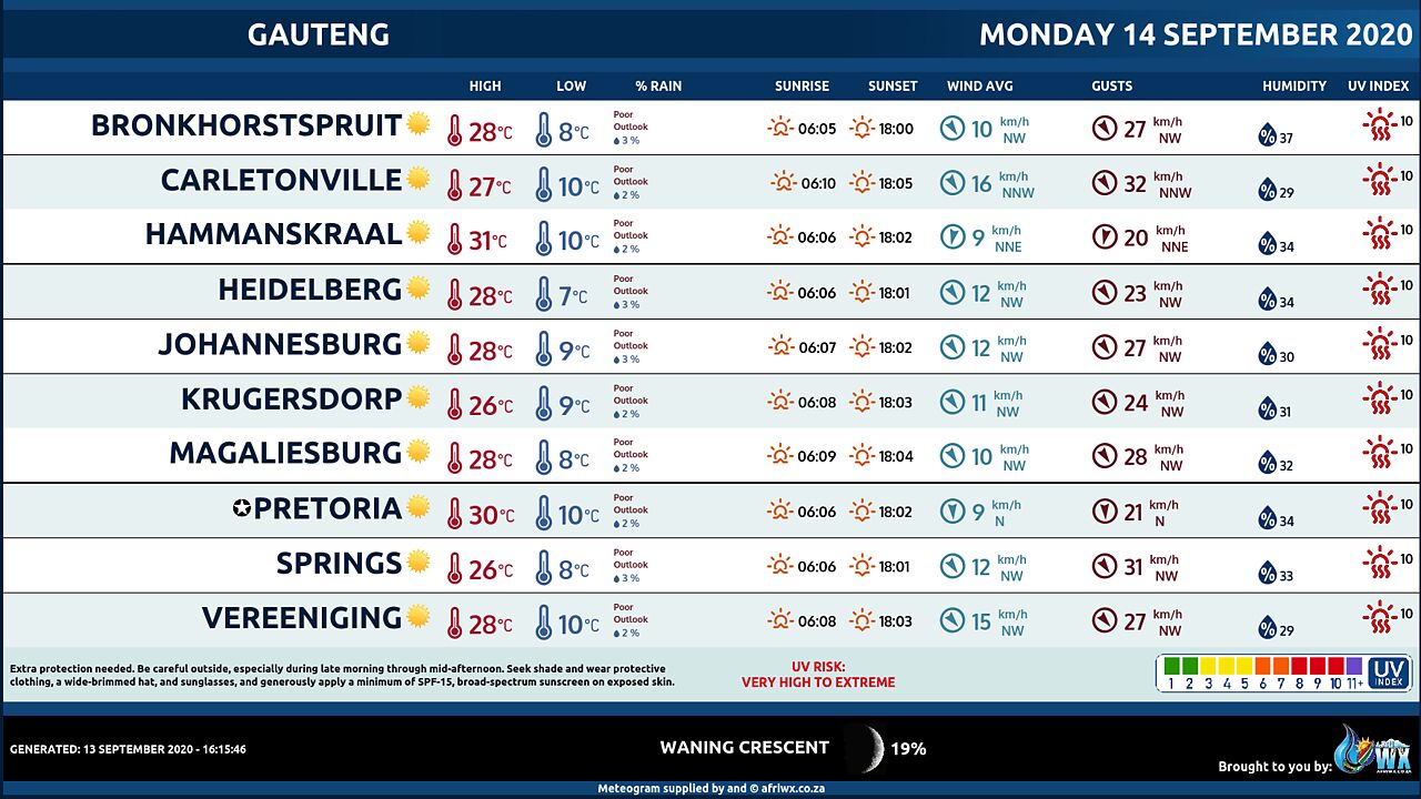
GAUTENG PROVINCE
Fine, becoming partly cloudy and warm. The expected UVB sunburn Index High
MPUMALANGA PROVINCE
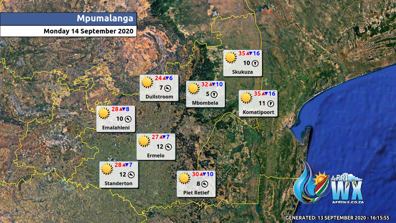
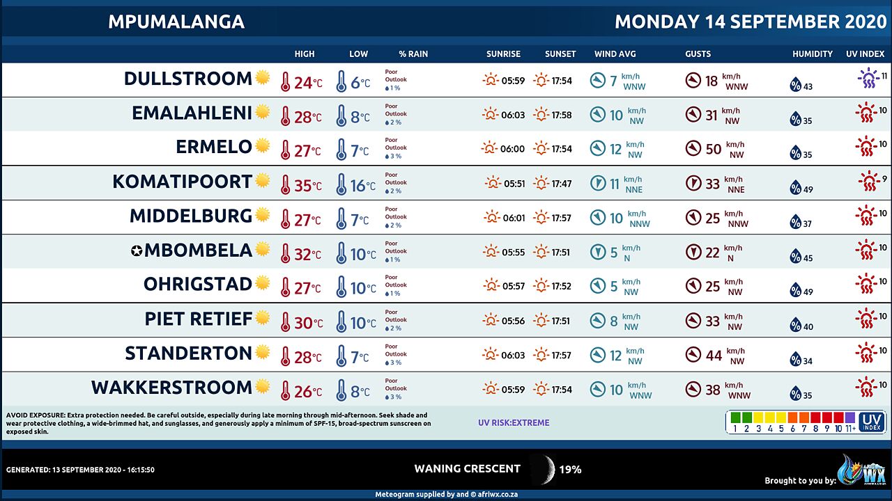
Fine and warm but hot in the Lowveld, becoming partly cloudy by late afternoon.
LIMPOPO PROVINCE
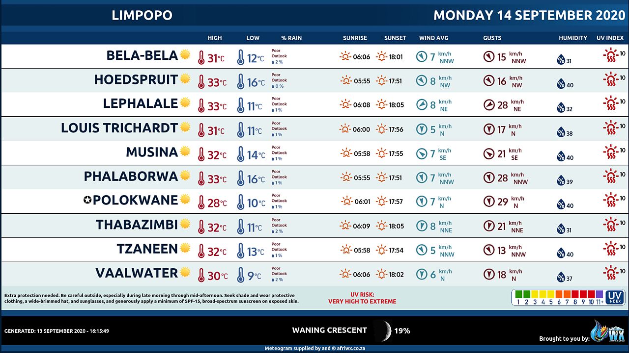
Fine and warm but hot in the Lowveld and the Limpopo Valley, becoming partly cloudy in the south by the late afternoon.
NORTH-WEST PROVINCE
Fine and warm becoming partly cloudy, except in the extreme west.
FREE STATE
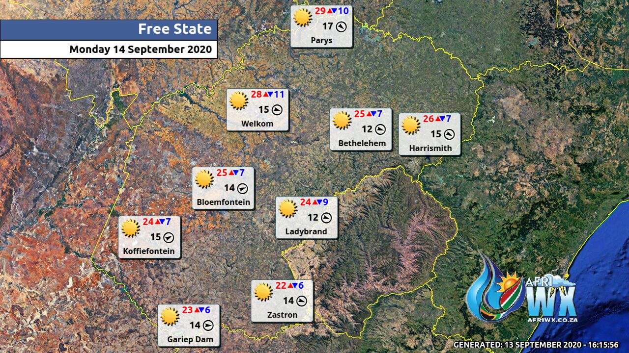
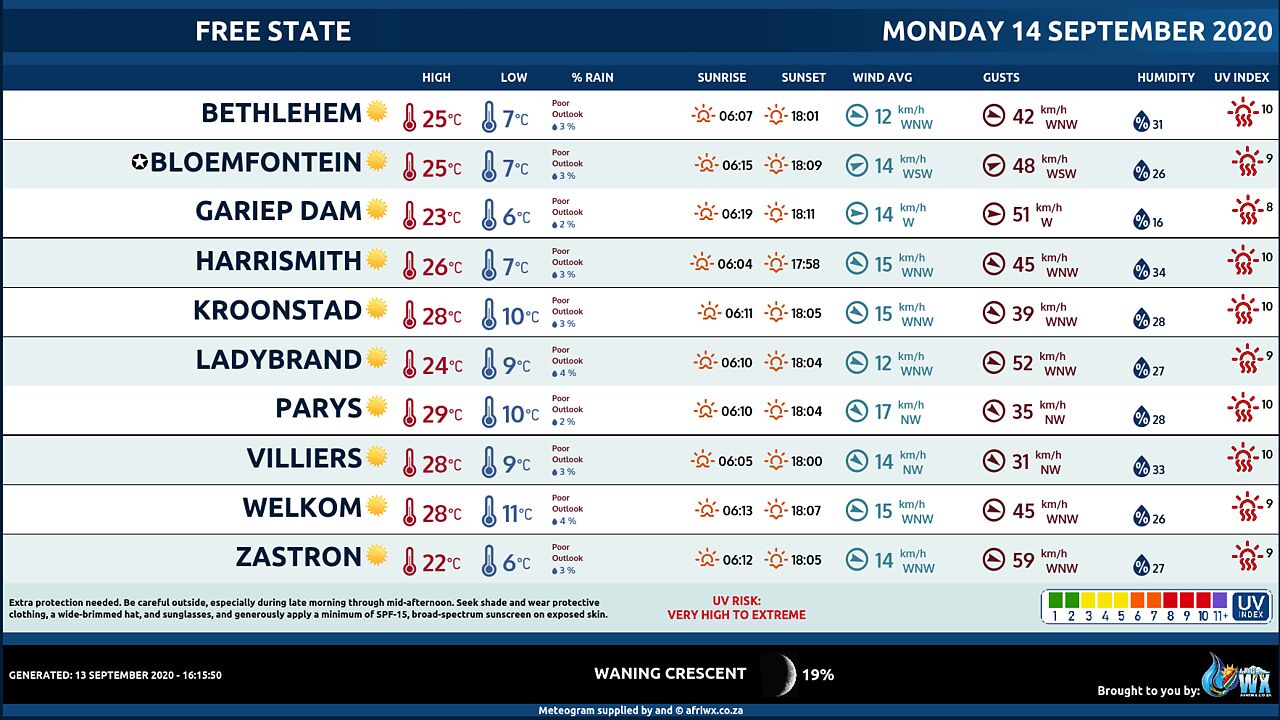
Fine and cool to warm, becoming partly cloudy in the afternoon, except in the west.
NORTHERN CAPE
Cloudy in the west at first, otherwise fine and cool to warm but partly cloudy in the southwest where it will be cold. The wind along the coast will be light to moderate northerly to north- westerly, becoming moderate to fresh southerly to south-easterly.
WESTERN CAPE
Fine in the extreme north east, otherwise partly cloudy and cold but cool along the west coast, with isolated showers and rain in the south west, spreading to the south coast by the afternoon. The wind along the coast will be moderate to fresh westerly to south- westerly but strong along the south coast at first. The expected UVB sunburn Index Moderate
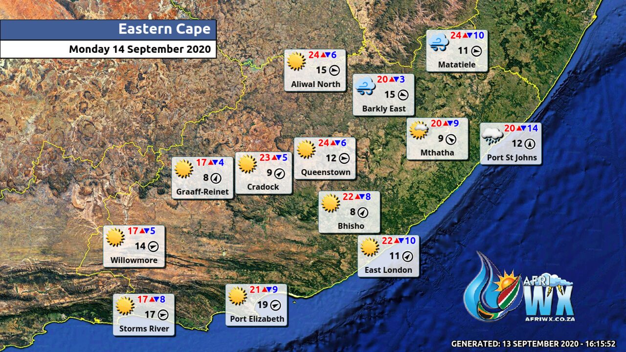
WESTERN HALF OF THE EASTERN CAPE
Partly cloudy in places in the south, otherwise fine and cool. It will become cloudy along the south coast in the afternoon, with light showers over the Tsitsikamma. The wind along the coast will be fresh to strong south-westerly.
EASTERN HALF OF THE EASTERN CAPE
Partly cloudy to cloudy in the east with light rain in the south-east, but partly cloudy over the south-western parts in the evening, otherwise fine and cool. The wind along the coast will be moderate south-westerly, becoming fresh west of East London in the afternoon.
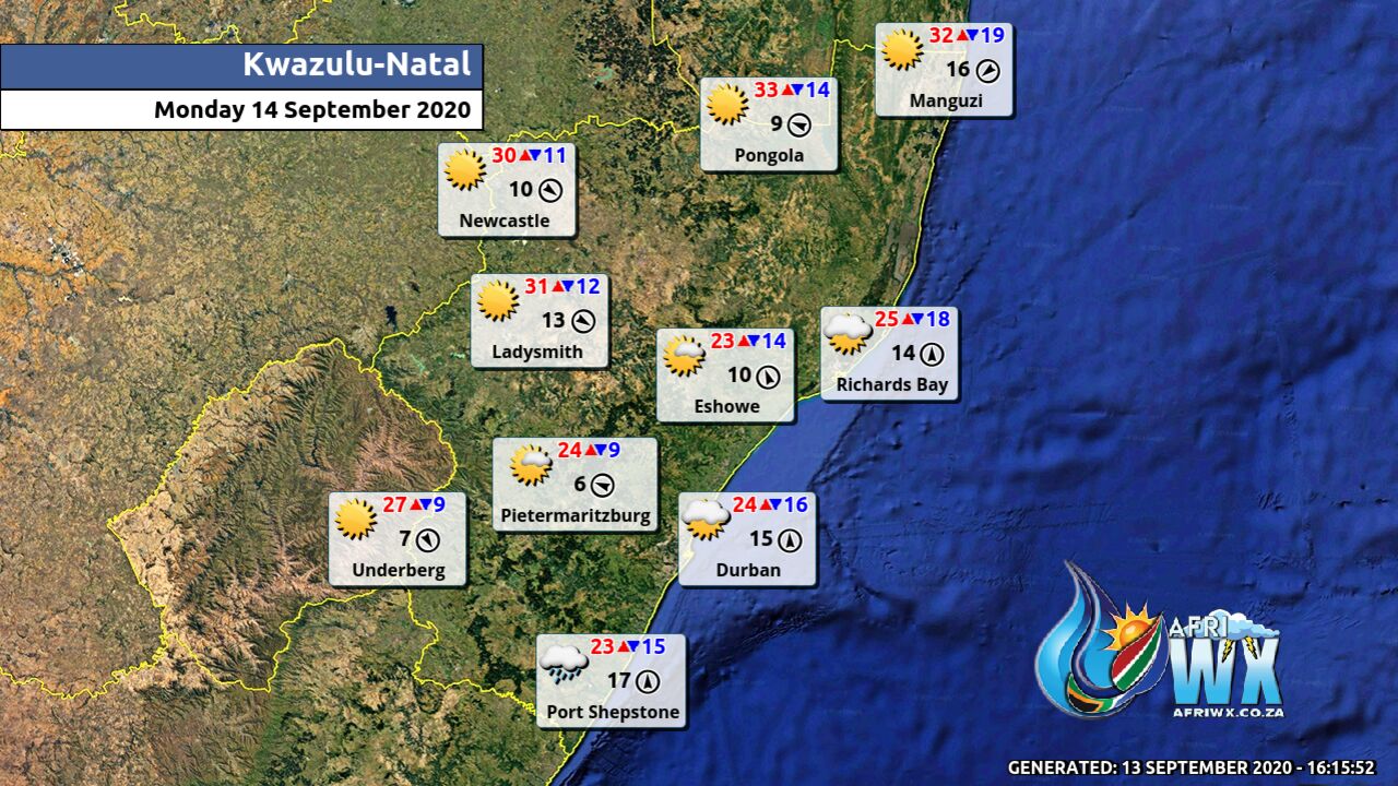
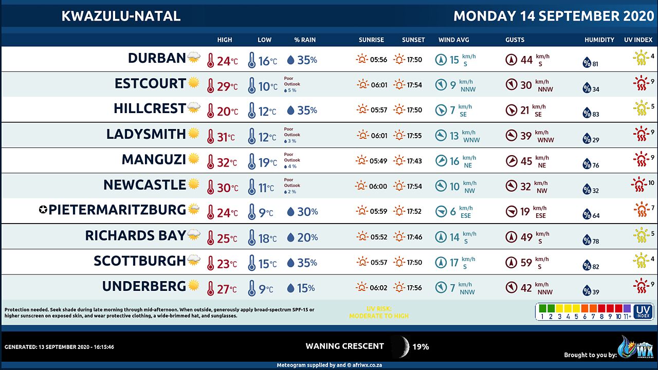
KWAZULU-NATAL
Morning mist patches in places over the interior, otherwise partly cloudy and cool but warm in the north. It will become cloudy by evening with isolated showers in the south-east. The wind along the coast will be moderate to fresh north-easterly in the north otherwise southerly to south-easterly. The expected UVB sunburn Index High
Join our free AfriWX channel on Telegram Messenger, please download Telegram for Android or iPhone if you want to always be up to date with the latest weather maps.
Click to join our Telegram Channel
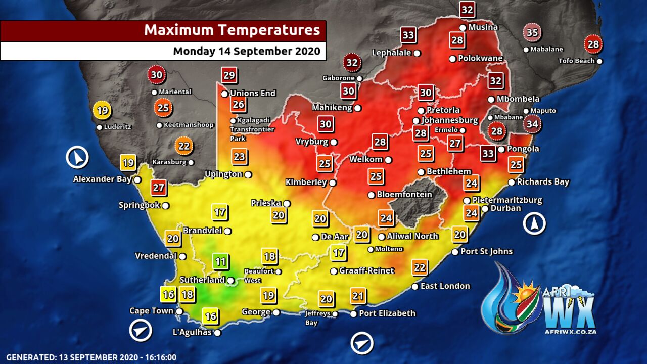
Maximum Temperatures Forecast for South Africa Monday 14 September 2020
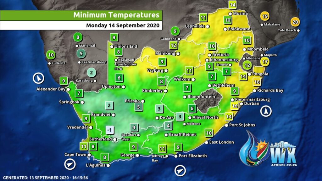
Minimum Temperatures Forecast for South Africa Monday 14 September 2020
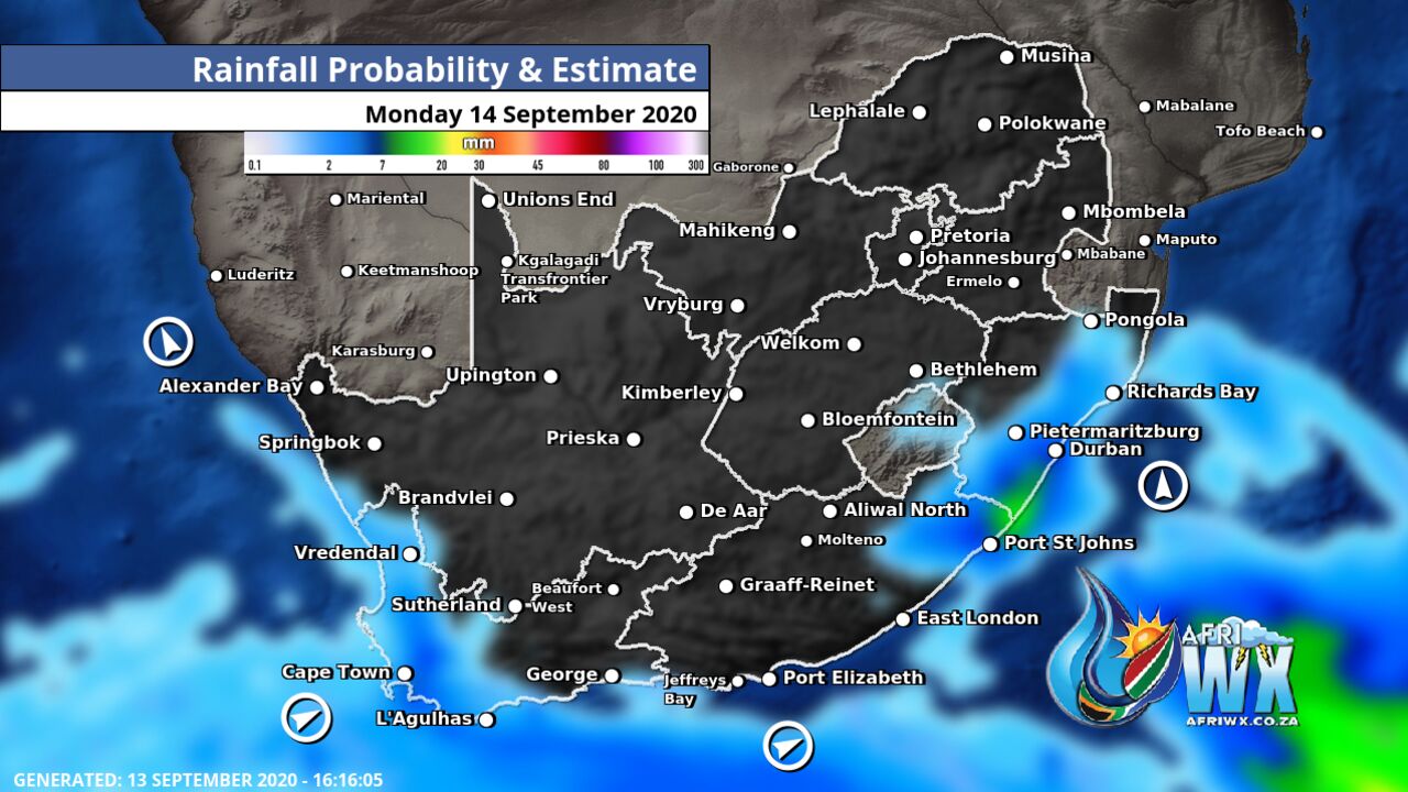
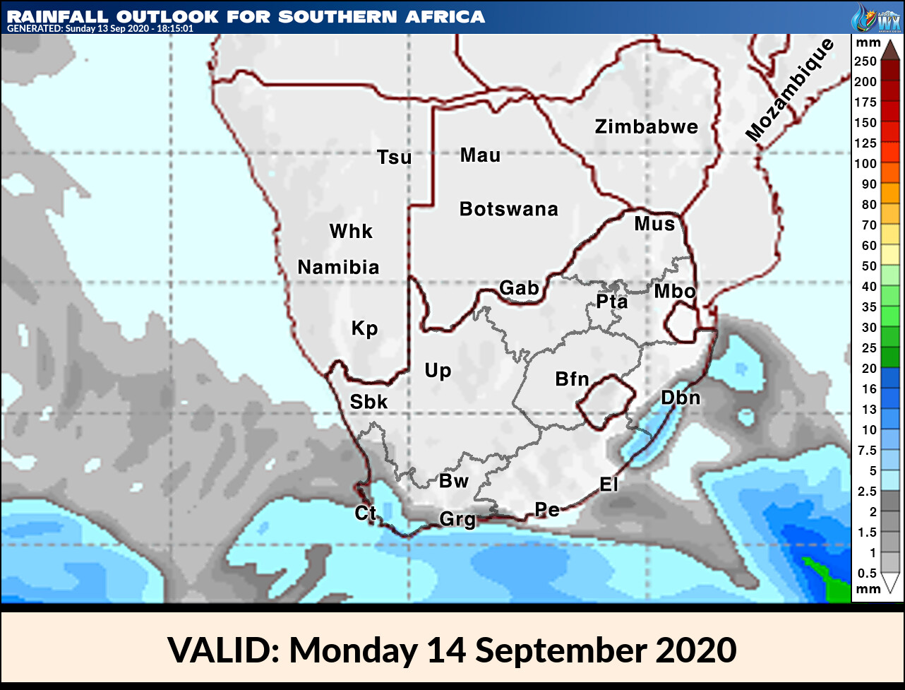
Rainfall Outlook for South Africa Monday 14 September 2020
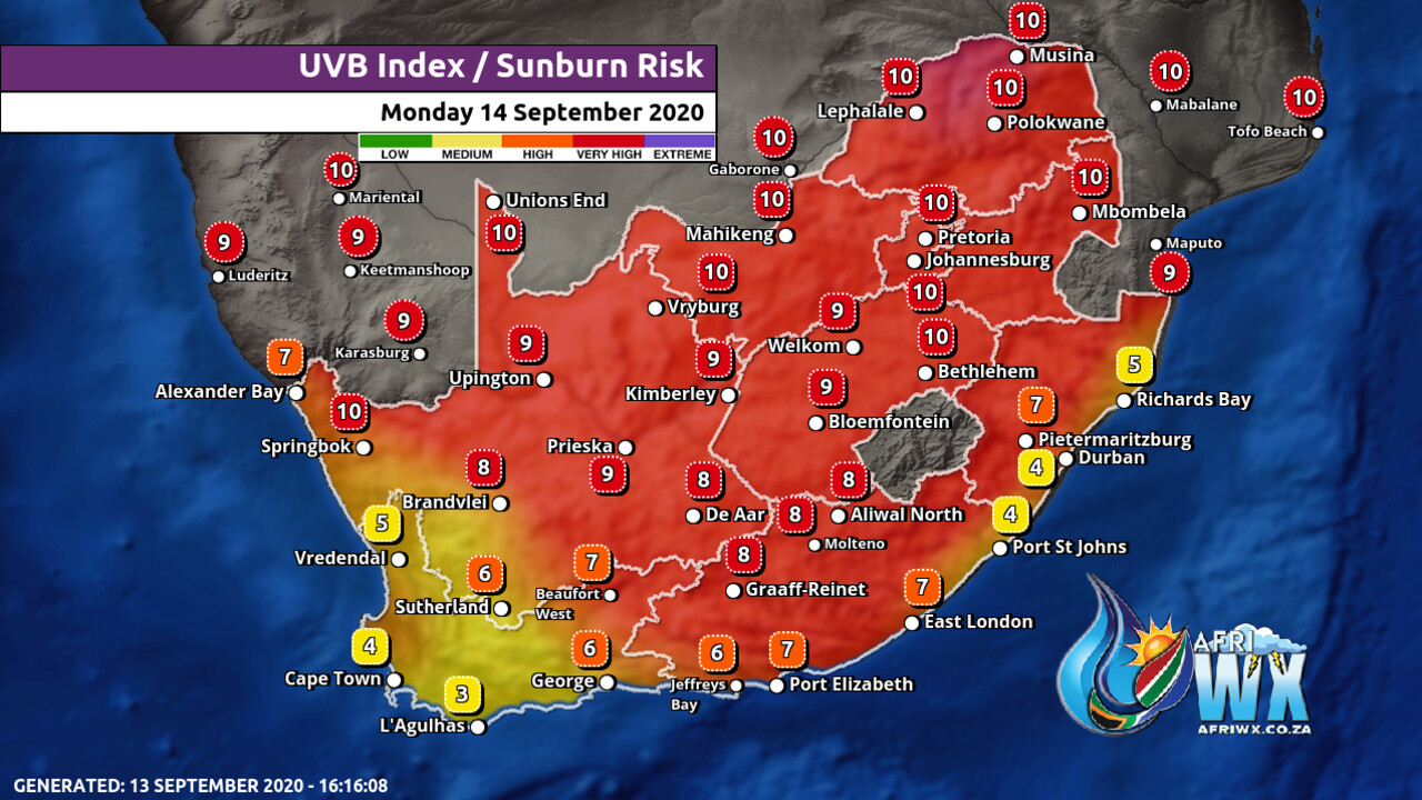
UVB Index Outlook for South Africa Monday 14 September 2020
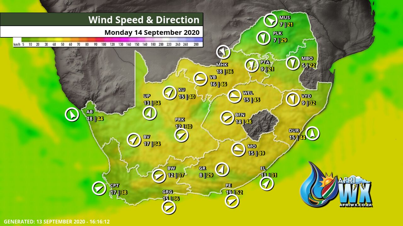
Wind Speed Direction and Gusts Map for South Africa Monday 14 September 2020
TRAVELLERS WEATHER FORECAST
FOR TOMORROW 2020-09-14
ISSUED AT 1530 SAST
BY THE SOUTH AFRICAN WEATHER SERVICE.
SEVERE WEATHER ALERTS
======================
WARNINGS
1.
Extremely high fire danger conditions are expected over the central parts of the Free State, western parts of the North West, and the north-eastern interior of the Eastern Cape.
WATCHES
1.
High seas with wave heights between 6-8m are expected between Cape Point and Plettenberg Bay in the morning, subsiding by the afternoon.
SPECIAL WEATHER ADVISORIES
Nil.
WEATHER IN OUR TOP CITIES
PRETORIA
Fine becoming partly cloudy.
Minimum/Maximum 11/27 The expected UVB Sunburn Index High
JOHANNESBURG
Fine becoming partly cloudy.
Minimum/Maximum 10/26
VEREENIGING
– Fine becoming partly cloudy.
Minimum/Maximum 09/26
MBOMBELA
Fine, becoming partly cloudy in the evening.
Minimum/Maximum 14/29
POLOKWANE
– Fine, becoming partly cloudy in the evening.
Minimum/Maximum 09/29
MAHIKENG
Fine, becoming partly cloudy.
Minimum/Maximum 12/29
VRYBURG
Fine, becoming partly cloudy.
Minimum/Maximum 09/30
BLOEMFONTEIN
Fine, becoming partly cloudy.
Minimum/Maximum 05/26
KIMBERLEY
– Fine.
Minimum/Maximum 06/26
UPINGTON
Fine.
Minimum/Maximum 08/21
CAPE TOWN
– Cloudy with isolated showers and rain, clearing by the afternoon.
Wind Moderate to fresh westerly, becoming light southerly.
Minimum/Maximum 12/15 The expected UVB Sunburn Index Moderate
GEORGE
Cloudy to partly cloudy, with isolated showers and rain by the afternoon, clearing by the evening.
Wind Fresh to strong westerly to south-westerly.
Minimum/Maximum 10/17
PORT ELIZABETH
– Partly cloudy.
Wind Fresh to strong south-westerly.
Minimum/Maximum 12/19
EAST LONDON
– Fine becoming partly cloudy in the evening.
Wind Moderate south-westerly.
Minimum/Maximum 13/20
DURBAN
Partly cloudy becoming cloudy in the afternoon with isolated showers.
Wind Moderate to fresh south-westerly becoming moderate south-easterly by THE afternoon.
Minimum/Maximum 17/22 The expected UVB Sunburn Index High
RICHARDS BAY
Partly cloudy becoming cloudy in the evening.
Wind Moderate south-westerly becoming south-easterly in the afternoon.
Minimum/Maximum 17/26
PIETERMARITZBURG
Partly cloudy with morning mist, otherwise cloudy with late afternoon showers.
Minimum/Maximum 12/21
Join our free AfriWX channel on Telegram Messenger, please download Telegram for Android or iPhone if you want to always be up to date with the latest weather maps.
Click to join our Telegram Channel
Rainfall Outlook for Tomorrow Monday 14 September 2020
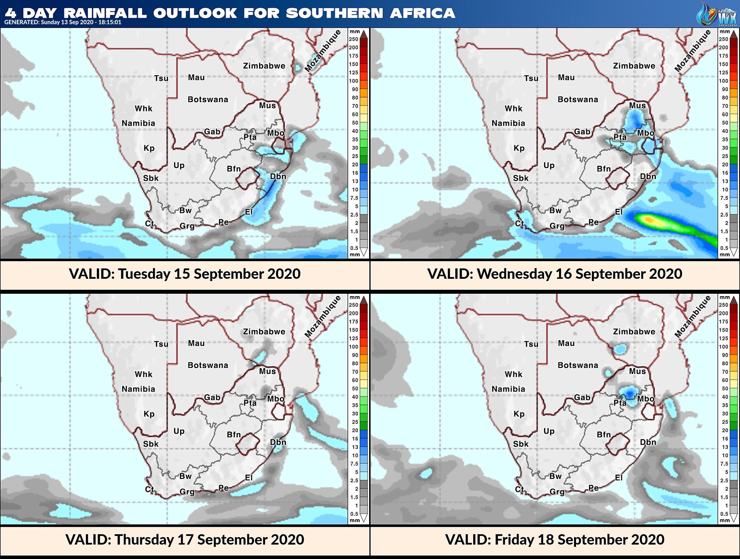
4 Day Rainfall Outlook for Southern Africa
14 Day Rainfall Outlook for Southern Africa
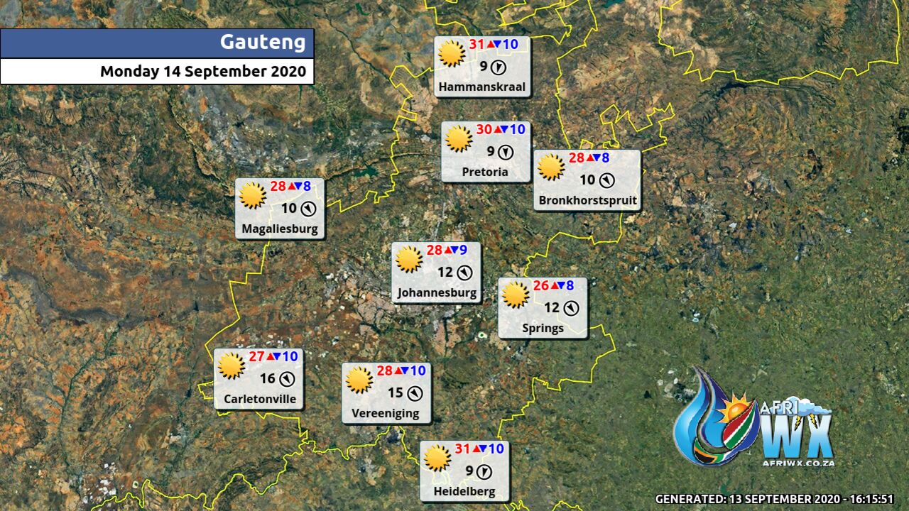
Gauteng Province Weather Map Monday 14 September 2020
Gauteng Province Weather Meteogram Monday 14 September 2020
Kwazulu-Natal Province Weather Map Monday 14 September 2020
Kwazulu-Natal Province Weather Meteogram Monday 14 September 2020
Eastern Cape Province Weather Map Monday 14 September 2020
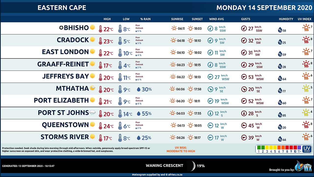
Eastern Cape Province Weather Meteogram Monday 14 September 2020
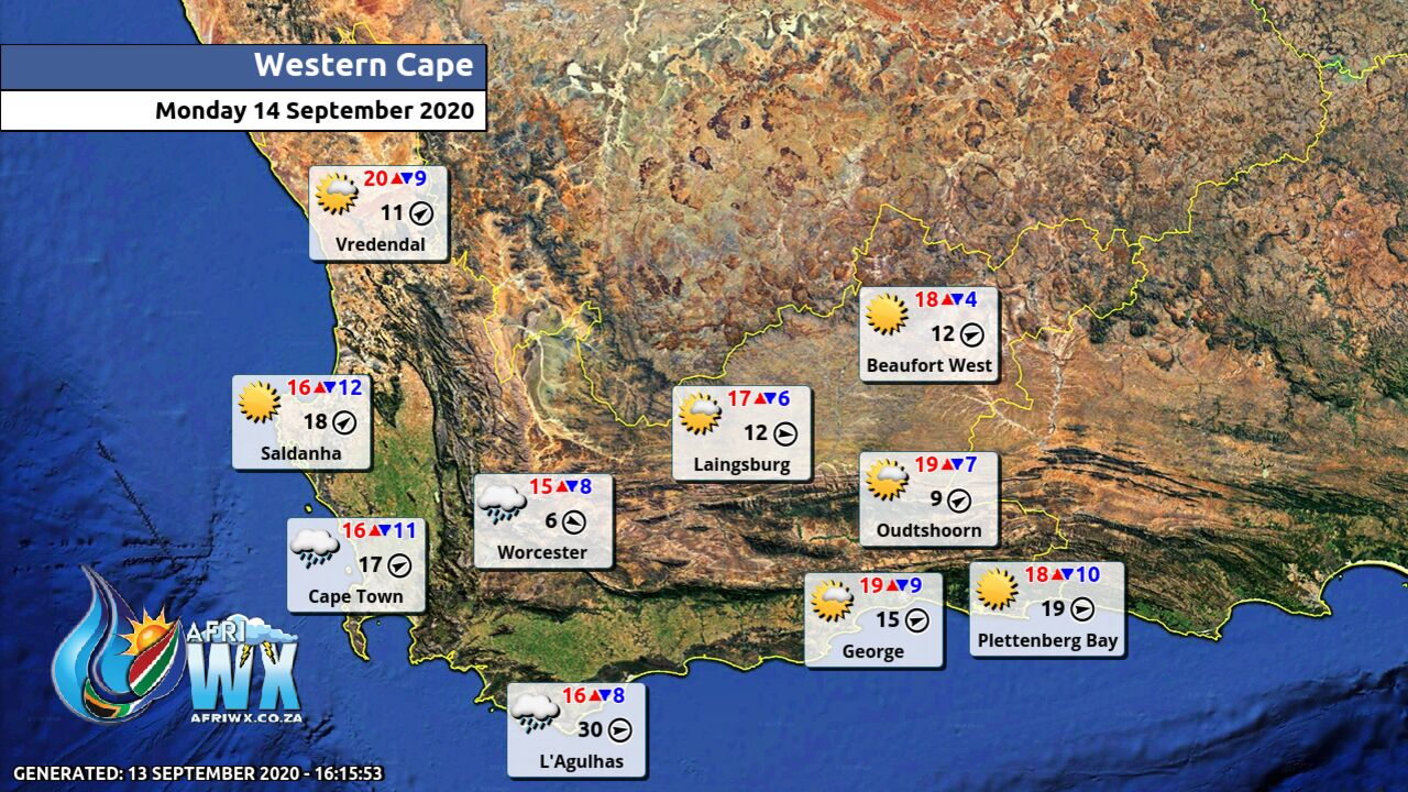
Western Cape Province Weather Map Monday 14 September 2020
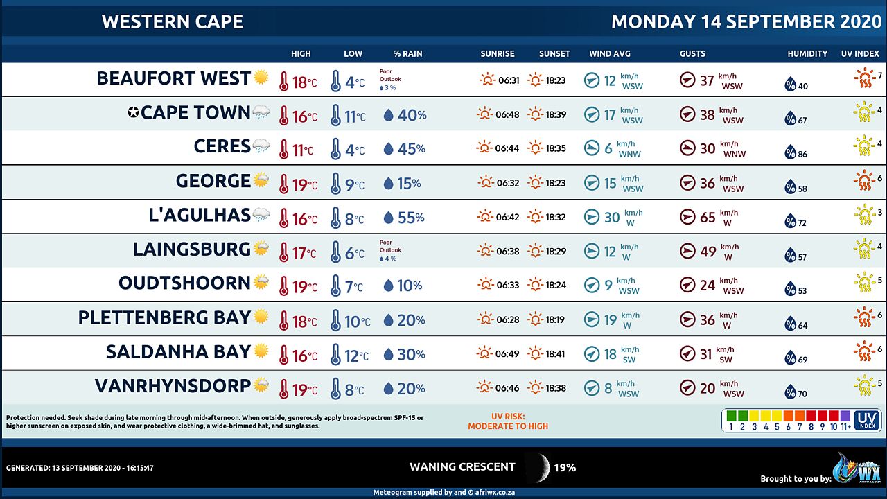
Western Cape Province Weather Meteogram Monday 14 September 2020
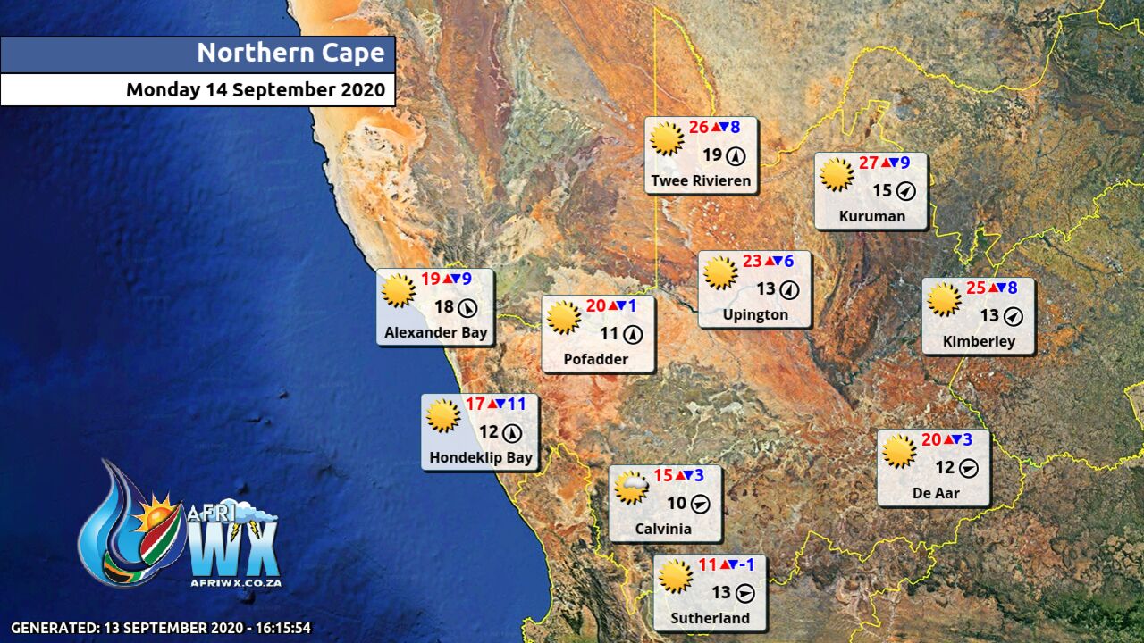
Northern Cape Province Weather Map Monday 14 September 2020
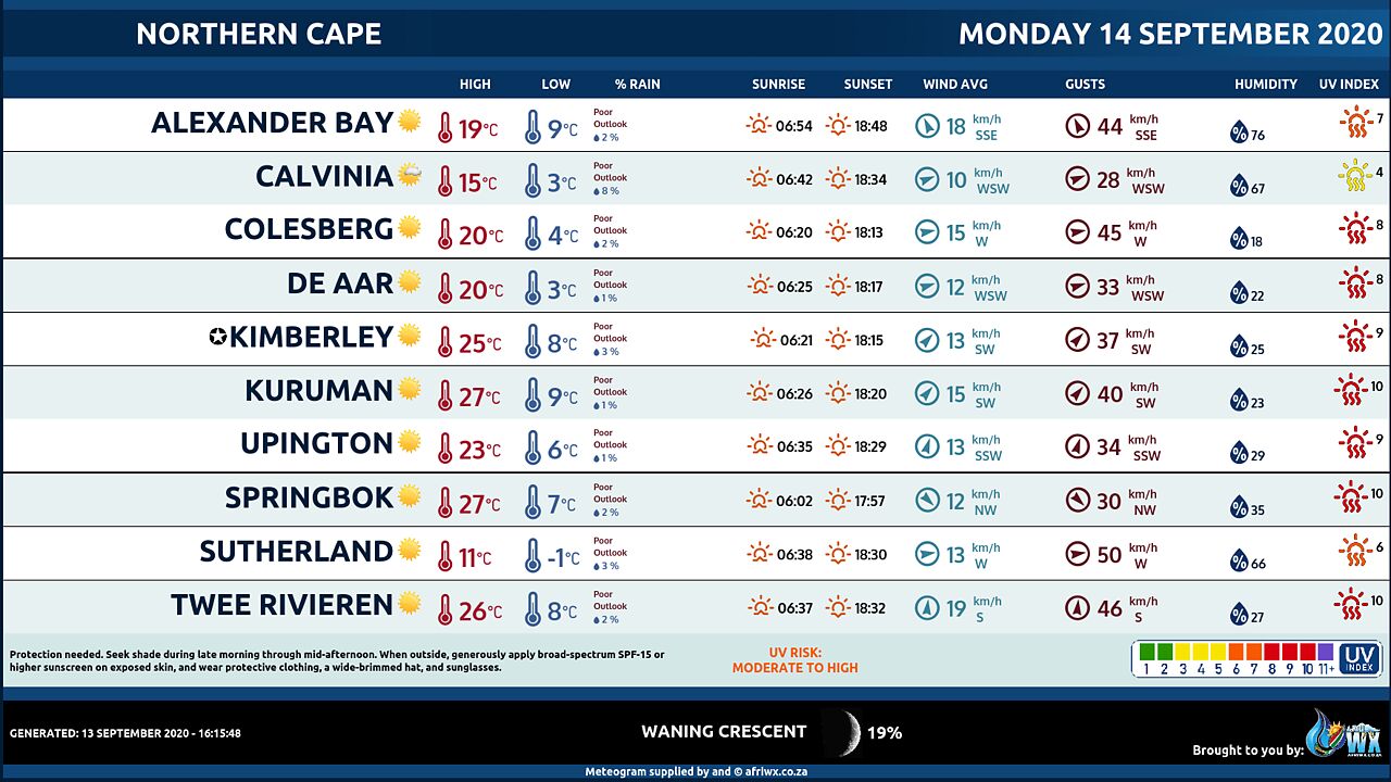
Northern Cape Province Weather Meteogram Monday 14 September 2020
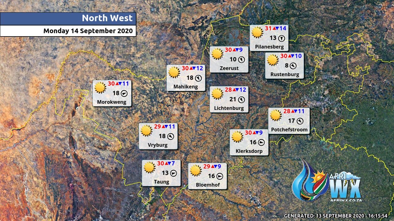
North-West Province Weather Map Monday 14 September 2020
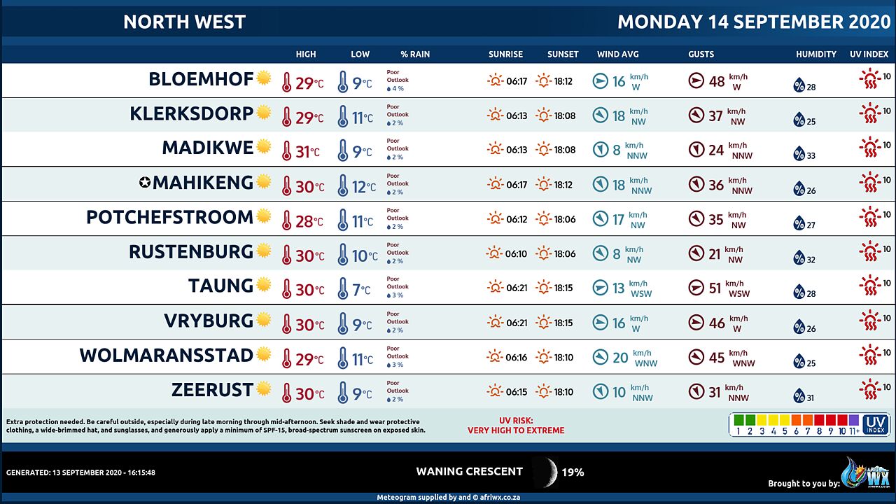
North-West Province Weather Meteogram Monday 14 September 2020
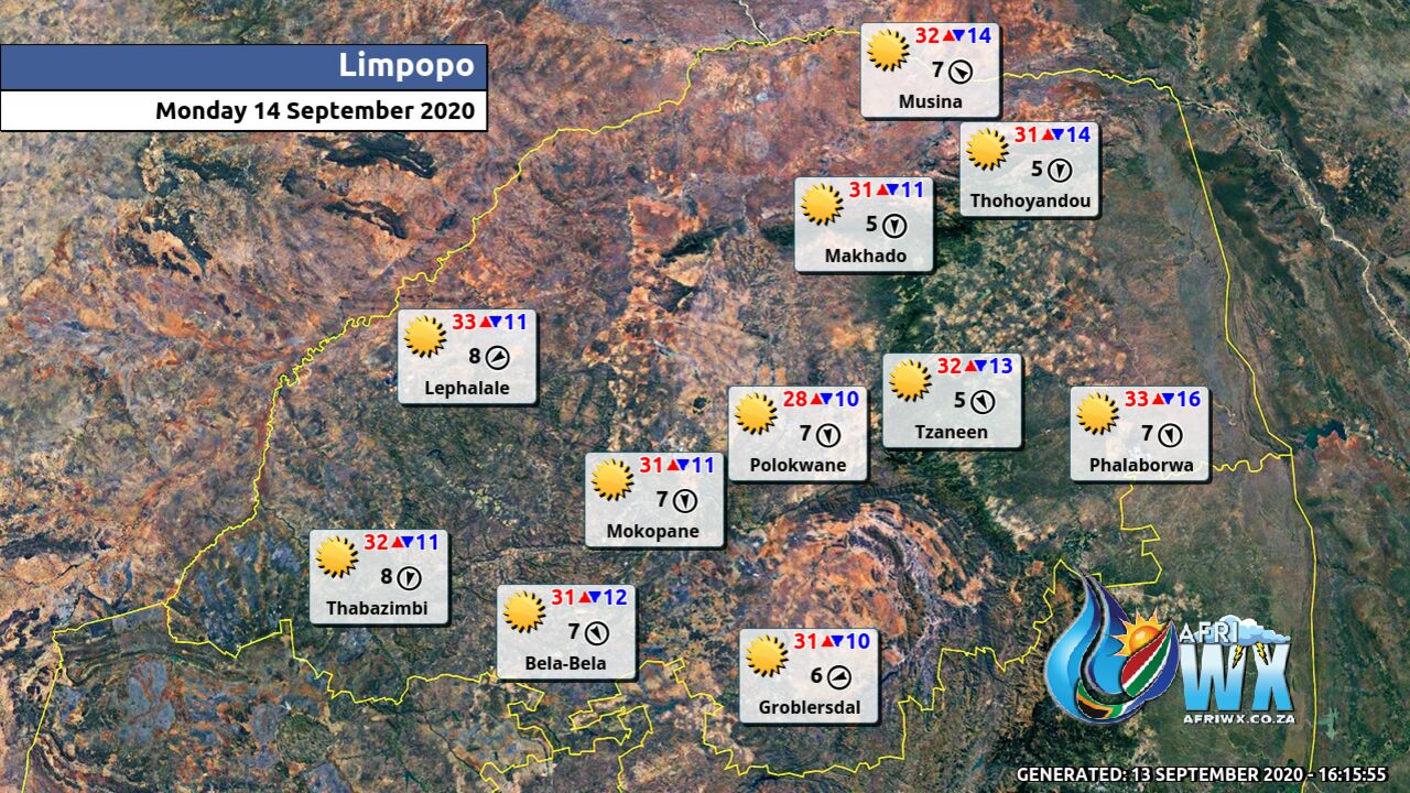
Limpopo Province Weather Map Monday 14 September 2020
Limpopo Province Weather Meteogram Monday 14 September 2020
Mpumalanga Province Weather Map Monday 14 September 2020
Mpumalanga Province Weather Meteogram Monday 14 September 2020
Free State Province Weather Map Monday 14 September 2020
Free State Province Weather Meteogram Monday 14 September 2020
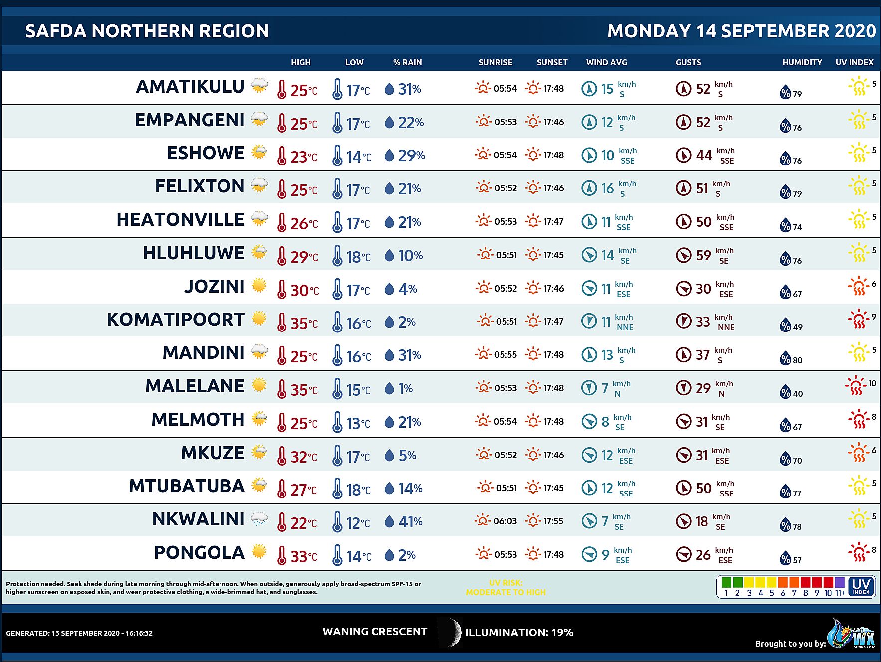
SAFDA Sugar Cane Farming (Northern Kwazulu-Natal) Weather Forecast Monday 14 September 2020
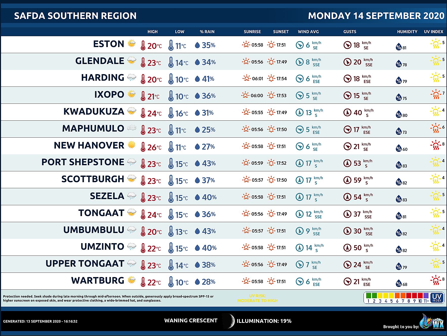
SAFDA Sugar Cane Farming (Southern Kwazulu-Natal) Weather Forecast Monday 14 September 2020
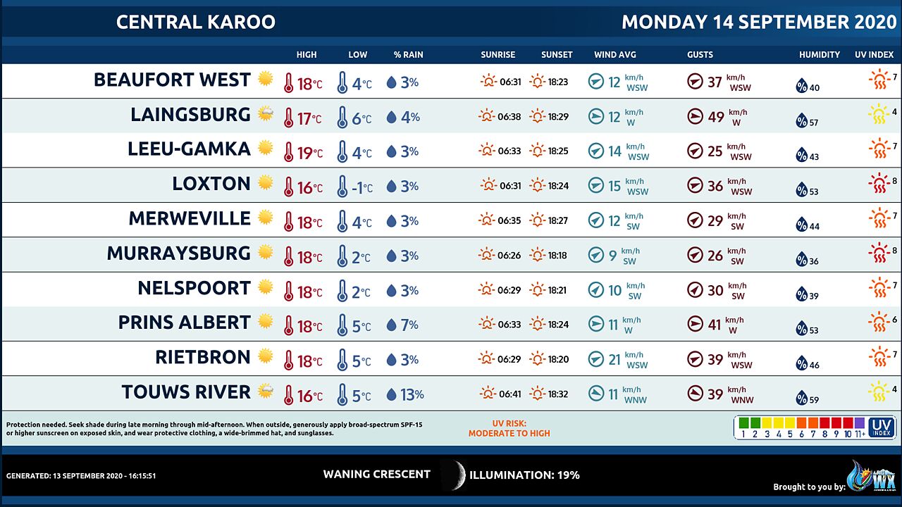
Central Karoo (Northern Cape) Farming Weather Forecast Monday 14 September 2020
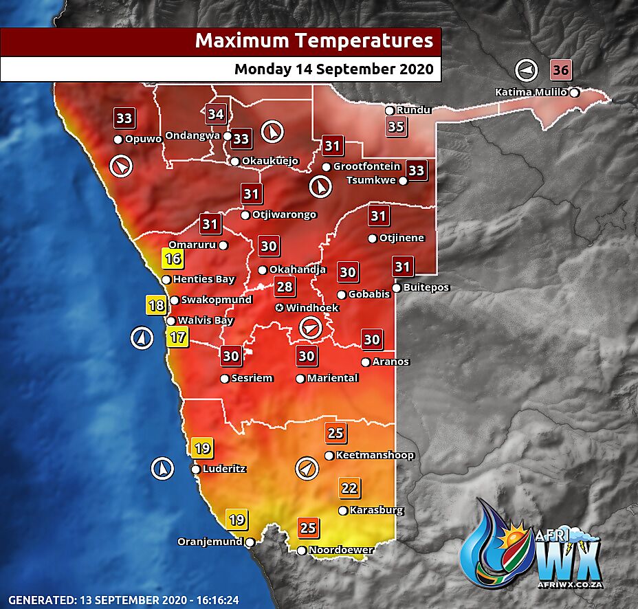
Namibia Maximum Temperatures Monday 14 September 2020
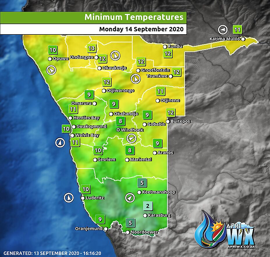
Namibia Minimum Temperatures Monday 14 September 2020
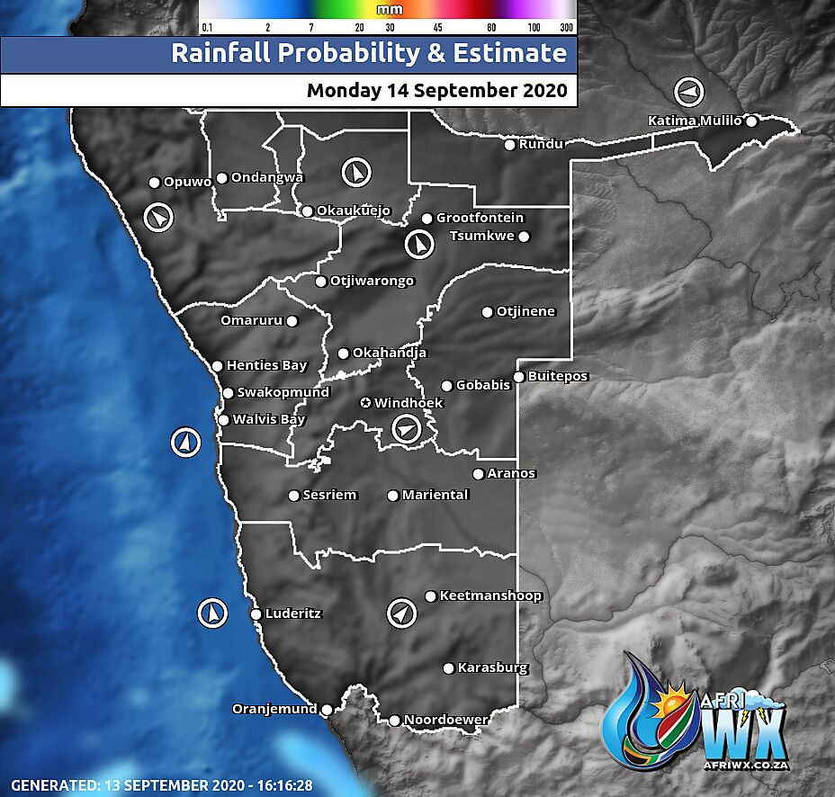
Namibia Rainfall Probability Map Monday 14 September 2020
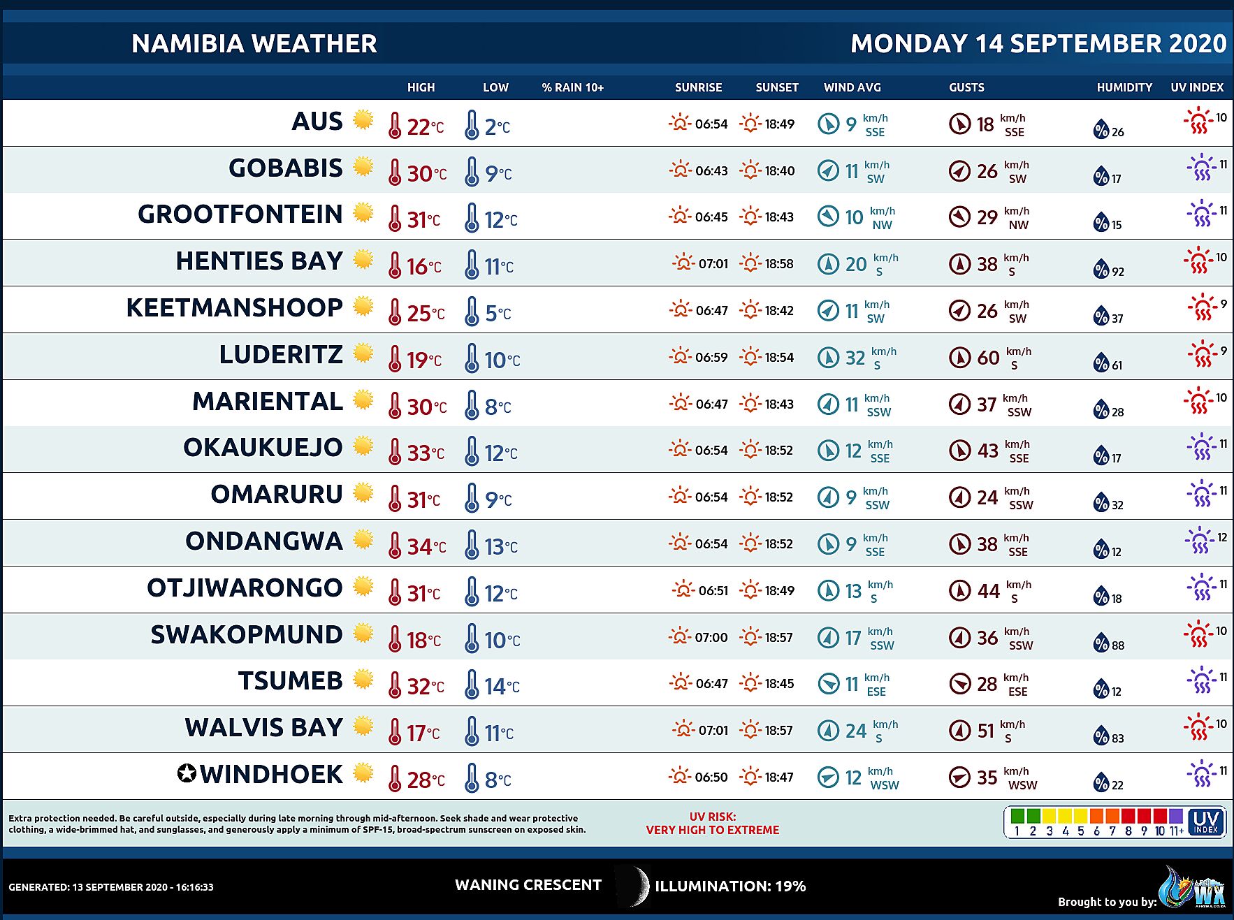
Namibia Weather Meteogram Monday 14 September 2020
Namibia Meteorological Services METEONA Weather Forecast Monday 14 September 2020
Weather Maps by SAWX – Feel Free to Share
Join our free AfriWX channel on Telegram Messenger, please download Telegram for Android or iPhone if you want to always be up to date with the latest weather maps.
Click to join our Telegram Channel

