Last Updated on 27th December 2020 6:30 PM by AfriWX
THE REGIONAL WEATHER FORECAST
FOR TOMORROW 2020-12-28
ISSUED AT 1330 SAST
BY THE SOUTH AFRICAN WEATHER SERVICE. THIS FORECAST WILL BE UPDATED AT 0600 SAST.
SEVERE WEATHER ALERTS
IMPACT-BASED
WARNINGS
Nil. FIRE DANGER
WARNINGS
1.Extremely high fire danger conditions are expected over the interior of Namakwa District and the central parts of the Northern Cape extending to the south-western parts of the Free State. ADVISORIES Nil.
PROVINCIAL WEATHER OVERVIEW
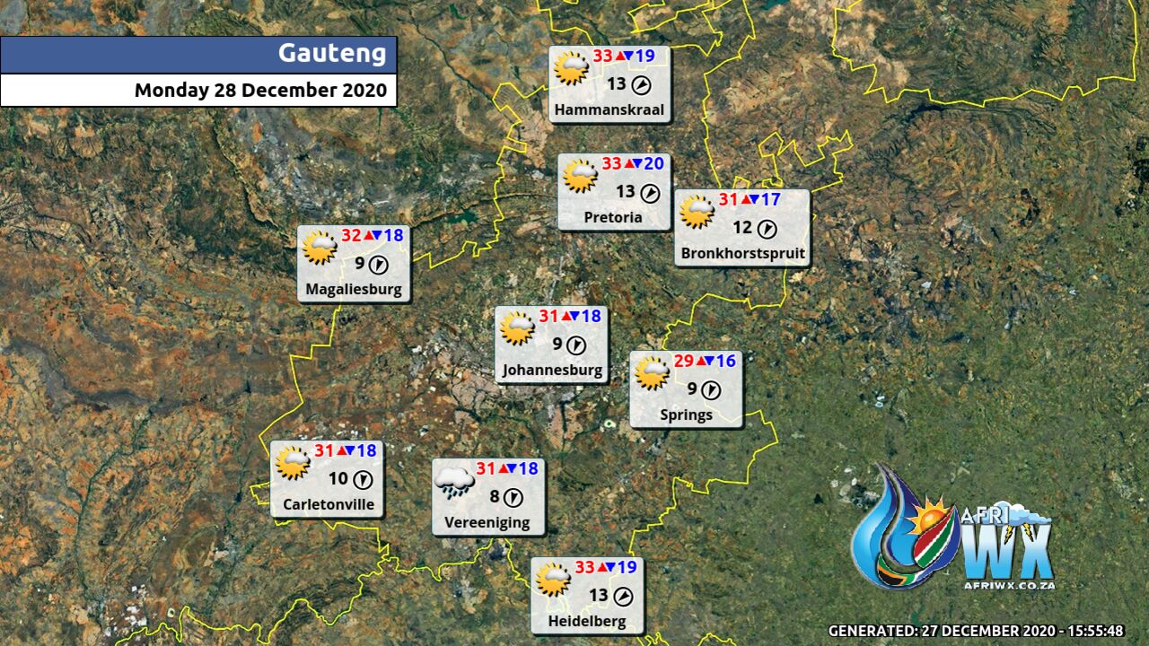
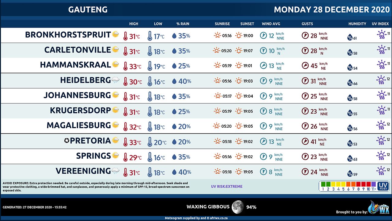
GAUTENG PROVINCE
Partly cloudy and warm with isolated showers and thundershowers. The expected UVB sunburn Index Extreme
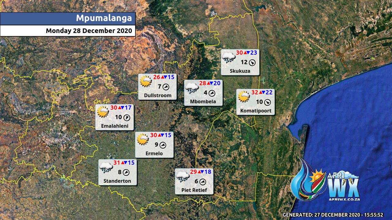
MPUMALANGA PROVINCE
Cloudy in the morning with fog patches along the escarpment, otherwise partly cloudy and warm with isolated thunderstorms.
LIMPOPO PROVINCE
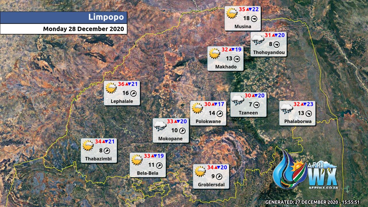
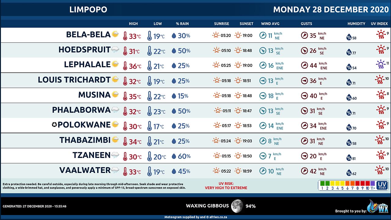
Cloudy in the east in the morning with fog patches along the escarpment, otherwise partly cloudy and warm to hot with isolated thunderstorms except in the north-east.
NORTH-WEST PROVINCE
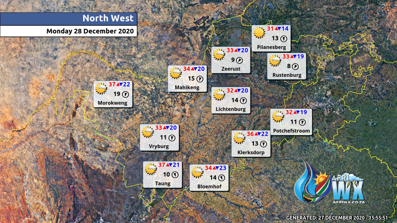
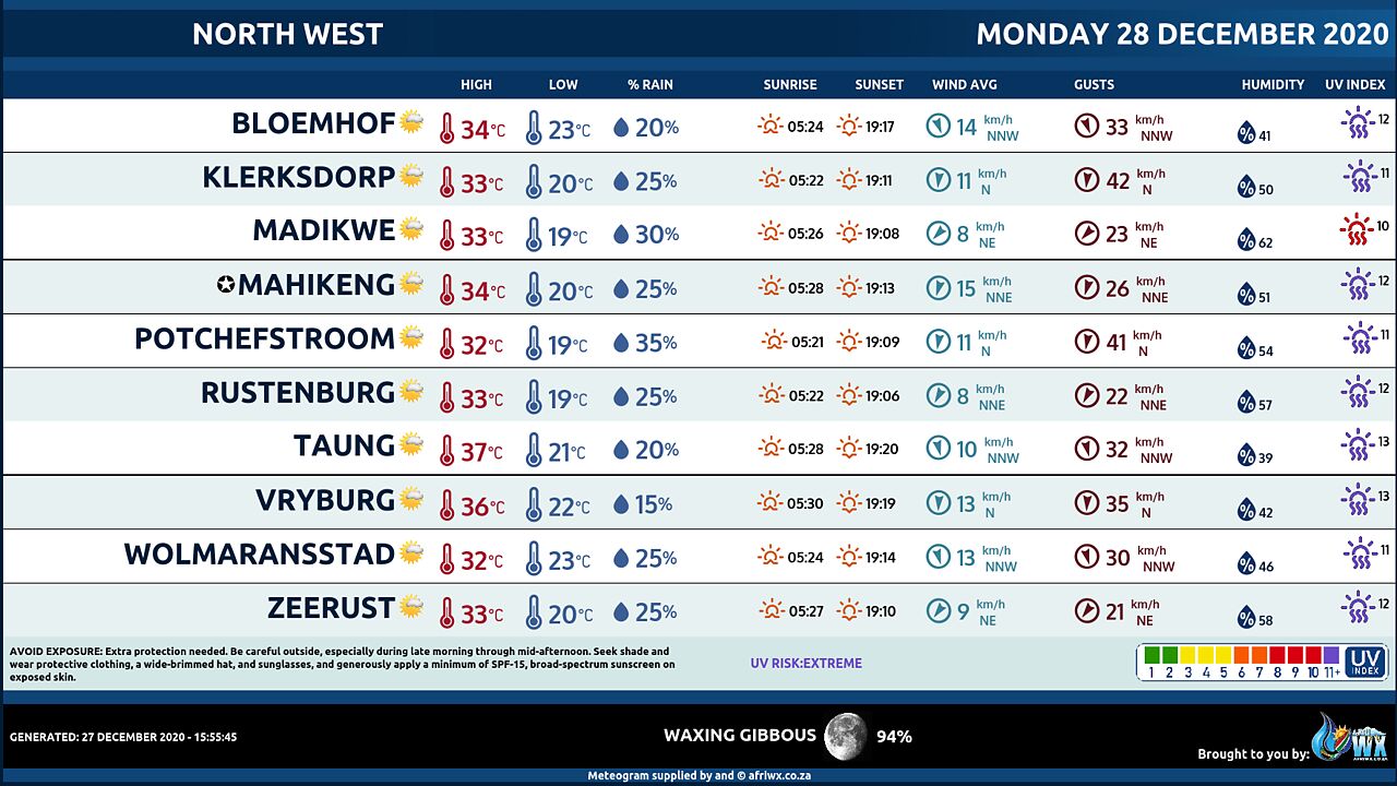
Partly cloudy and hot with isolated showers and thundershowers in the afternoon except in the extreme west.
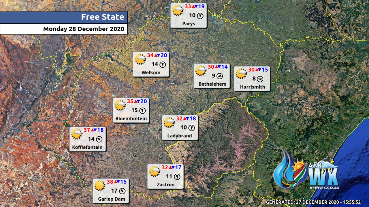
FREE STATE
Partly cloudy and warm to hot with isolated showers and thundershowers except in the south-western parts.
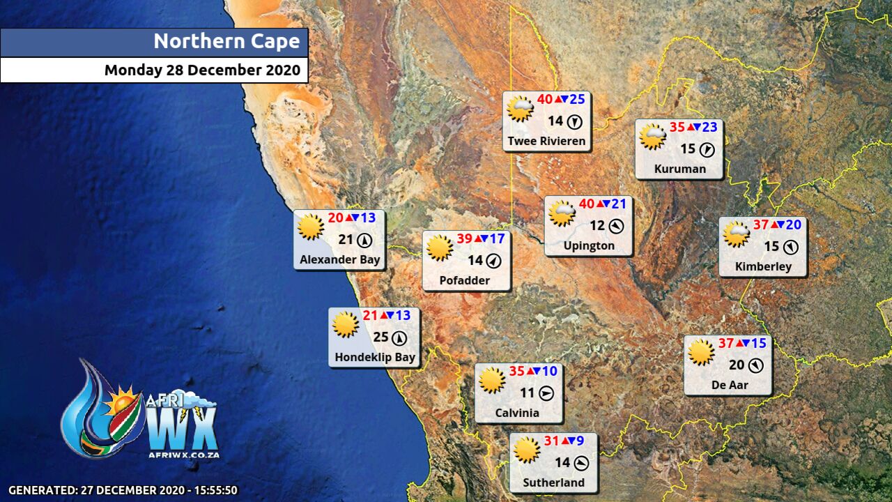
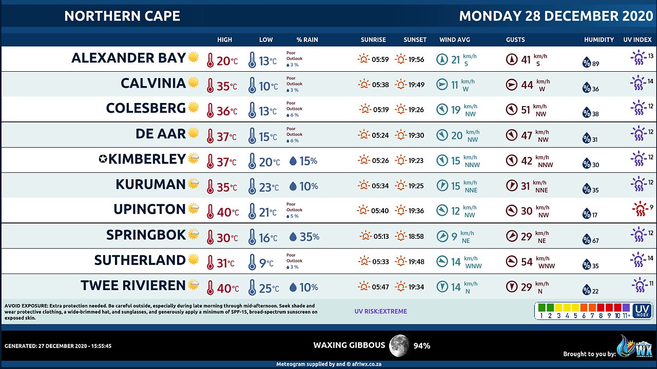
NORTHERN CAPE
Cloudy to partly cloudy and cool to warm but hot to very hot in the east with morning fog in the north-west, becoming fine by the afternoon. The wind along the coast will be light to moderate south-westerly in the morning, becoming moderate to fresh southerly to south-easterly from the afternoon.
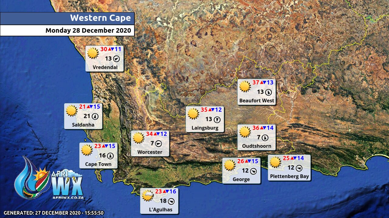
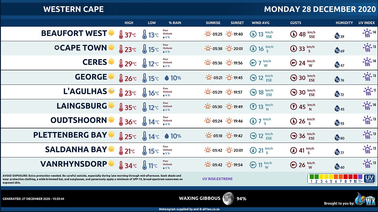
WESTERN CAPE
Cloudy to partly cloudy along the south coast and over the interior in the morning, otherwise fine and warm to hot over the Little and Central Karoo. The wind along the coast will be moderate to fresh southerly to south-easterly at times along the west coast. The expected UVB sunburn Index Extreme
WESTERN HALF OF THE EASTERN CAPE
Cloudy in places in the morning otherwise fine and warm to hot. The wind along the coast will be Moderate to fresh easterly.
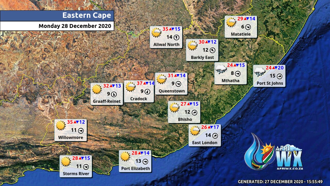
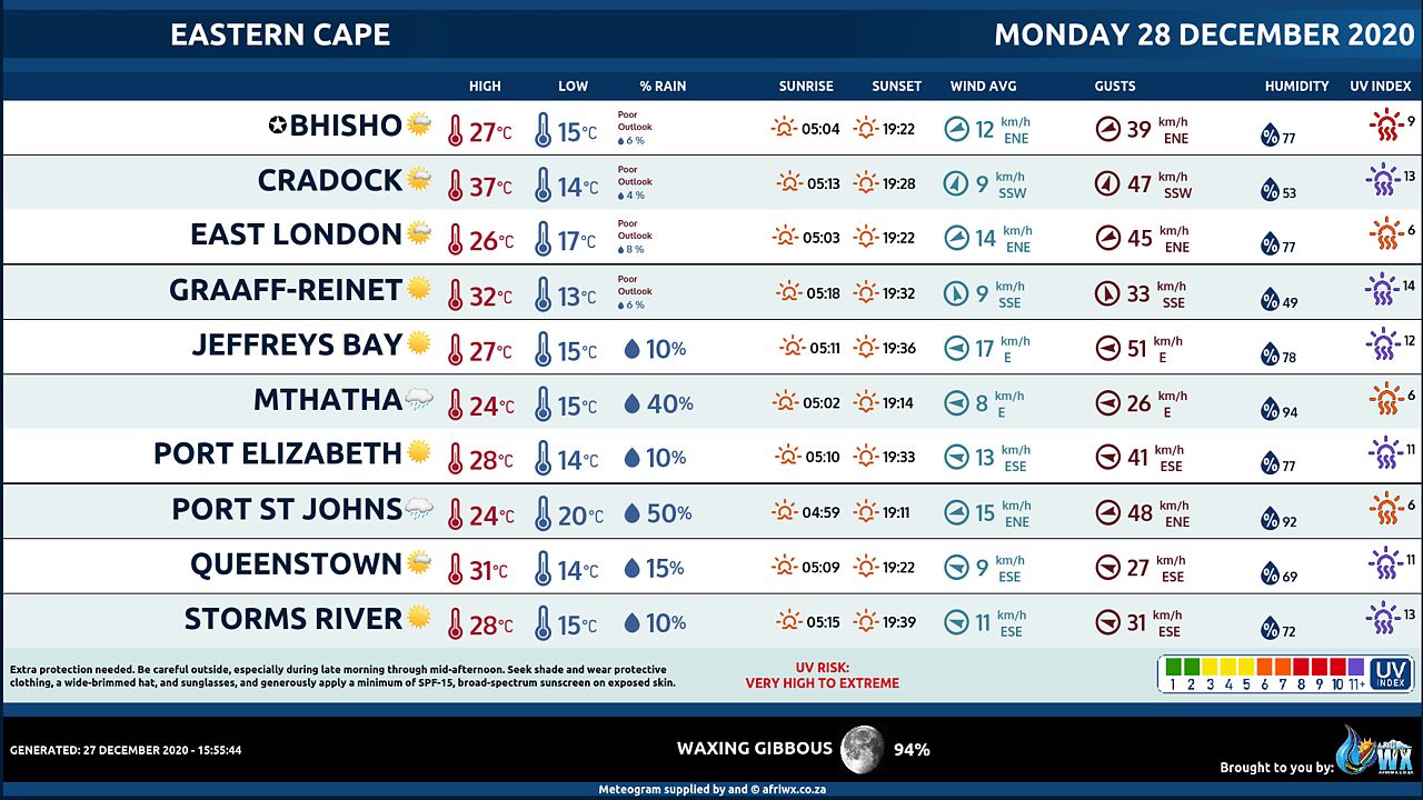
EASTERN HALF OF THE EASTERN CAPE
Cloudy and warm with isolated showers and thundershowers in the east. The wind along the coast will be Moderate to fresh north easterly.
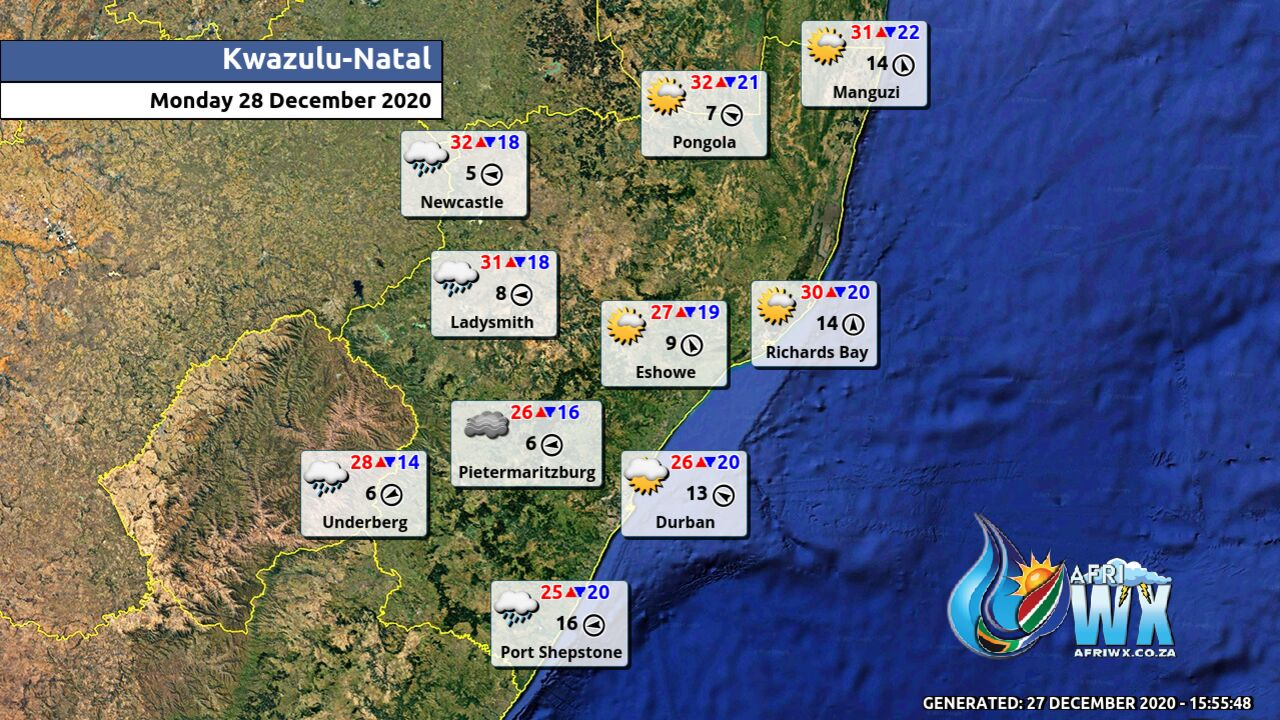
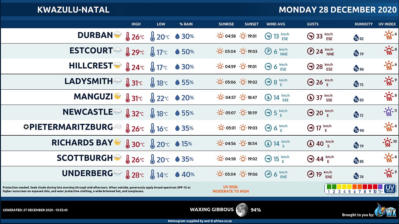
KWAZULU-NATAL
Morning fog over the interior, otherwise cloudy and cool but warm in the north. Isolated showers and thundershowers are exected, except over the north-eastern parts. The wind along the coast will be gentle to moderate southerly to south-westerly, becoming easterly to south-easterly from the south from late morning spreading to Maputo by late afternoon.It will become moderate to fresh north-easterly south of Durban by late afternoon. The expected UVB sunburn Index Low
Join our free AfriWX channel on Telegram Messenger, please download Telegram for Android or iPhone if you want to always be up to date with the latest weather maps.
Click to join our Telegram Channel
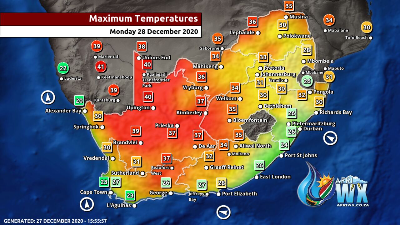
Maximum Temperatures Forecast for South Africa Monday 28 December 2020
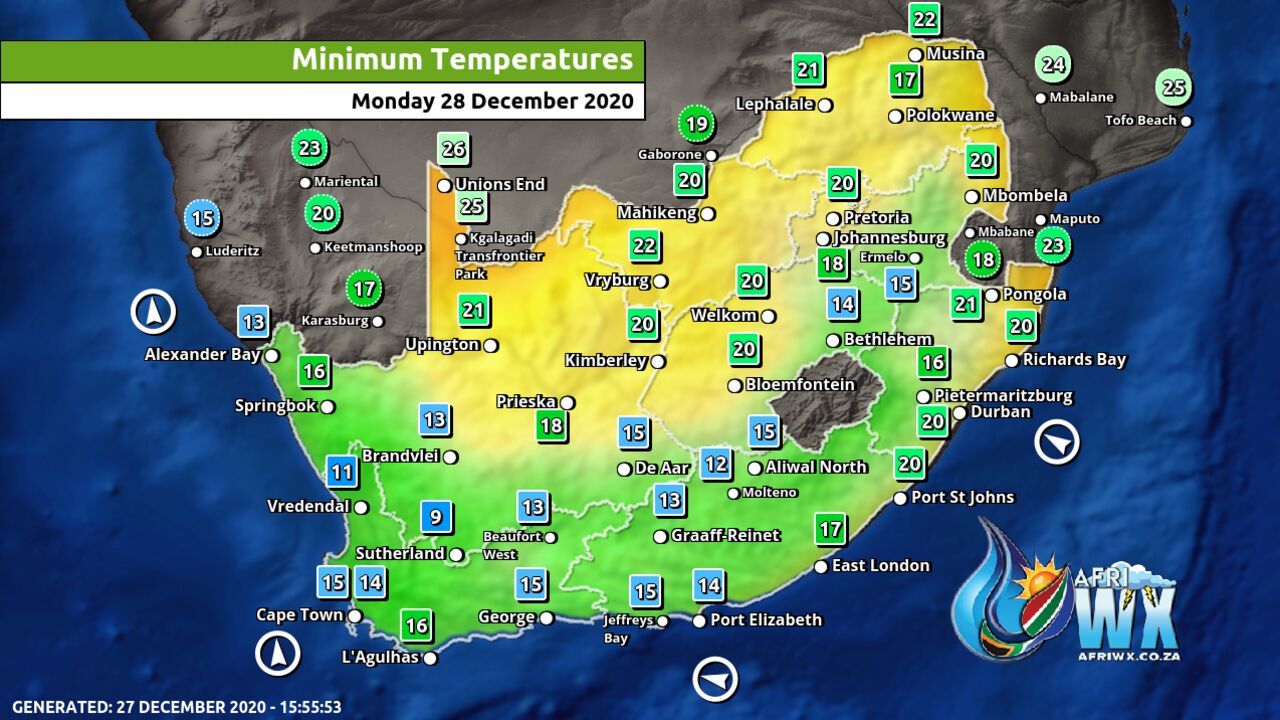
Minimum Temperatures Forecast for South Africa Monday 28 December 2020
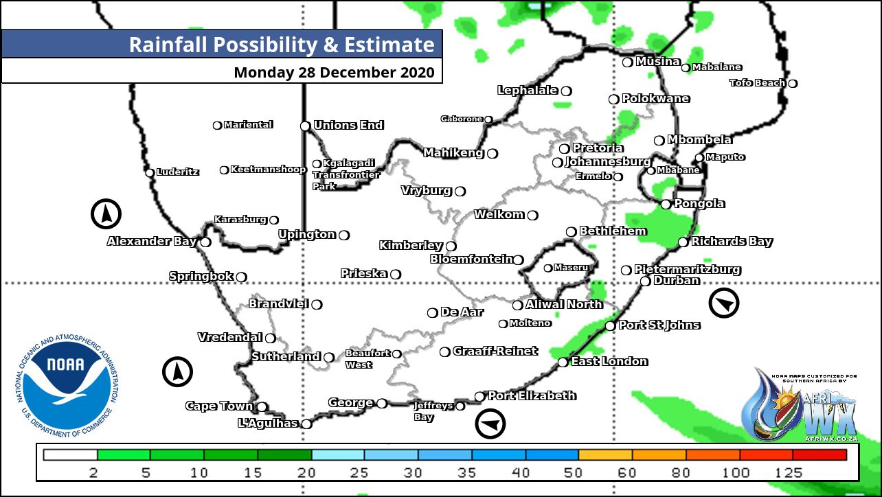
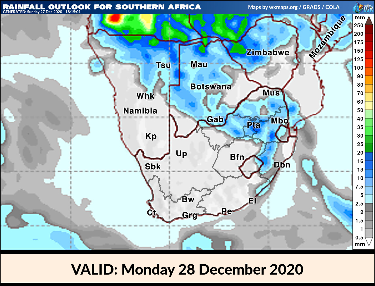
Rainfall Outlook for South Africa Monday 28 December 2020
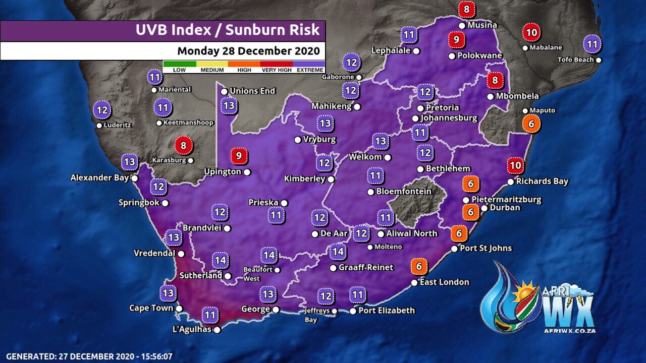
UVB Index Outlook for South Africa Monday 28 December 2020
TRAVELLERS WEATHER FORECAST
FOR TOMORROW 2020-12-28
ISSUED AT 1330 SAST
BY THE SOUTH AFRICAN WEATHER SERVICE.
SEVERE WEATHER ALERTS
IMPACT-BASED
WARNINGS
Nil.
FIRE DANGER
WARNINGS
1.
Extremely high fire danger conditions are expected over the interior of Namakwa District and the central parts of the Northern Cape extending to the south-western parts of the Free State.
ADVISORIES Nil.
WEATHER IN OUR TOP CITIES
PRETORIA
Partly cloudy with isolated showers and thundershowers.
Minimum/Maximum 19/32 The expected UVB Sunburn Index Extreme
JOHANNESBURG
Partly cloudy with isolated showers and thundershowers.
Minimum/Maximum 17/29
VEREENIGING
Partly cloudy with isolated showers and thundershowers.
Minimum/Maximum 17/30
MBOMBELA
Cloudy in the morning with fog patches, becoming partly cloudy with isolated thunderstorms.
Minimum/Maximum 16/30
POLOKWANE
Partly cloudy with isolated thunderstorms.
Minimum/Maximum 18/28
MAHIKENG
Partly cloudy with isolated showers and thundershowers.
Minimum/Maximum 21/33
VRYBURG
Partly cloudy with isolated showers and thundershowers.
Minimum/Maximum 23/34
BLOEMFONTEIN
Partly cloudy.
Minimum/Maximum 19/35
KIMBERLEY
Fine,becoming partly cloudy.
Minimum/Maximum 21/35
UPINGTON
Fine.
Minimum/Maximum 23/39
CAPE TOWN
Fine.
Wind Light to moderate southerly.
Minimum/Maximum 15/29 The expected UVB Sunburn Index Extreme
GEORGE
Cloudy in the early morning; otherwise fine.
Wind Moderate south-easterly.
Minimum/Maximum 15/25
PORT ELIZABETH
Cloudy becoming fine by midday.
Wind Moderate to fresh easterly.
Minimum/Maximum 18/24
EAST LONDON
Cloudy becoming partly cloudy.
Wind Light and variable in the morning otherwise moderate to fresh north-easterly towards midday.
Minimum/Maximum 18/25
DURBAN
Cloudy with isolated showers.
Windgentle southerly to south-easterly in the morning, becoming moderate easterly to north-easterly in the afternoon.
Minimum/Maximum 22/24 The expected UVB Sunburn Index Low
RICHARDS BAY
Partly cloudy becoming cloudy in the late afternoon.
WindModerate south-westerly, becoming southerly to south-easterly in the afternoon.
Minimum/Maximum 23/28
PIETERMARITZBURG
Cloudy with isolated showers and thundershowers.
Minimum/Maximum 18/24
Join our free AfriWX channel on Telegram Messenger, please download Telegram for Android or iPhone if you want to always be up to date with the latest weather maps.
Click to join our Telegram Channel
Rainfall Outlook for Tomorrow Monday 28 December 2020
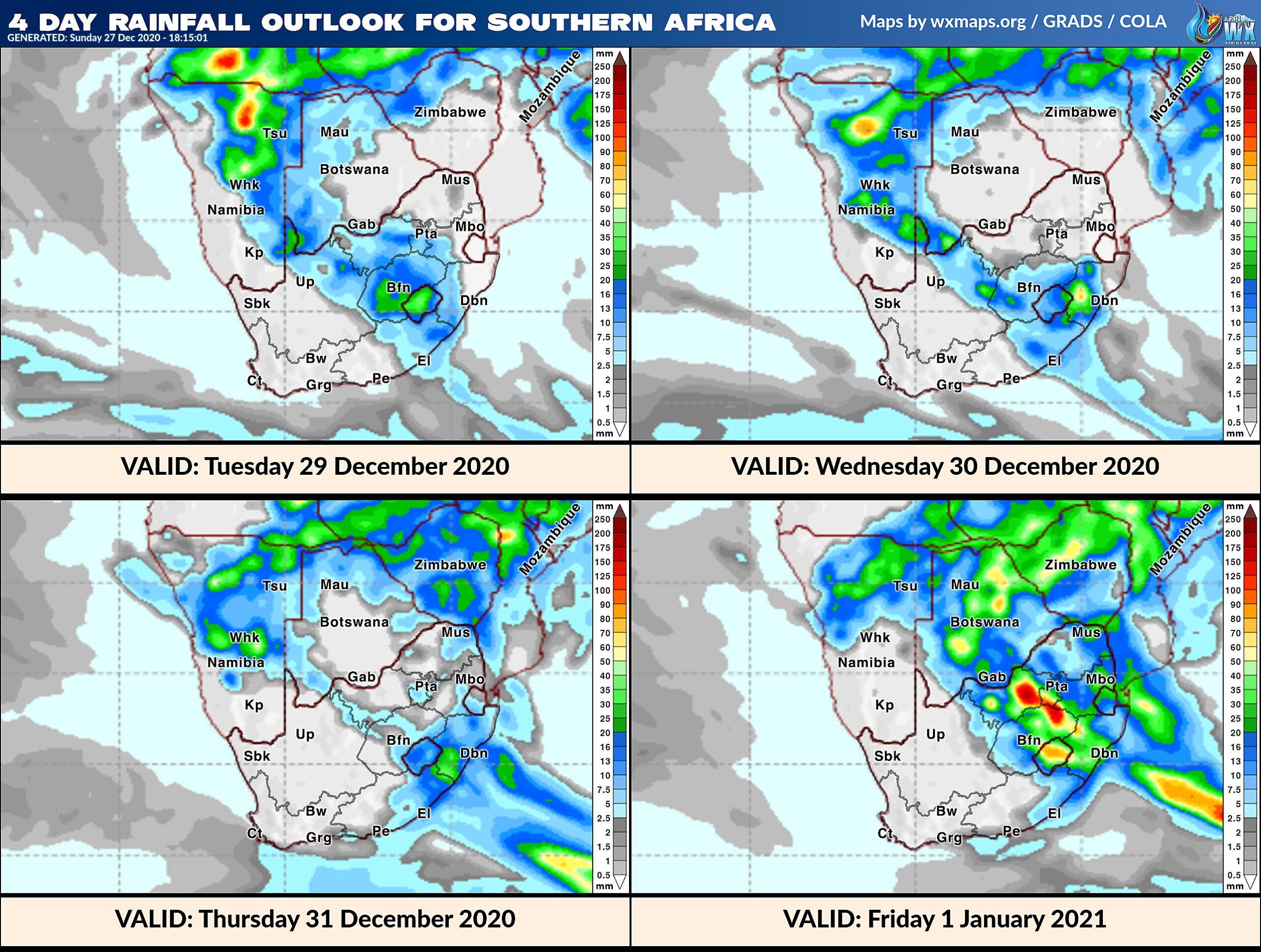
4 Day Rainfall Outlook for Southern Africa
14 Day Rainfall Outlook for Southern Africa
Gauteng Province Weather Map Monday 28 December 2020
Gauteng Province Weather Meteogram Monday 28 December 2020
Kwazulu-Natal Province Weather Map Monday 28 December 2020
Kwazulu-Natal Province Weather Meteogram Monday 28 December 2020
Eastern Cape Province Weather Map Monday 28 December 2020
Eastern Cape Province Weather Meteogram Monday 28 December 2020
Western Cape Province Weather Map Monday 28 December 2020
Western Cape Province Weather Meteogram Monday 28 December 2020
Northern Cape Province Weather Map Monday 28 December 2020
Northern Cape Province Weather Meteogram Monday 28 December 2020
North-West Province Weather Map Monday 28 December 2020
North-West Province Weather Meteogram Monday 28 December 2020
Limpopo Province Weather Map Monday 28 December 2020
Limpopo Province Weather Meteogram Monday 28 December 2020
Mpumalanga Province Weather Map Monday 28 December 2020
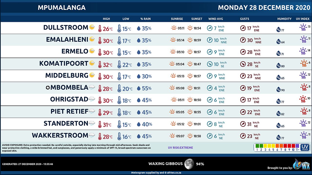
Mpumalanga Province Weather Meteogram Monday 28 December 2020
Free State Province Weather Map Monday 28 December 2020
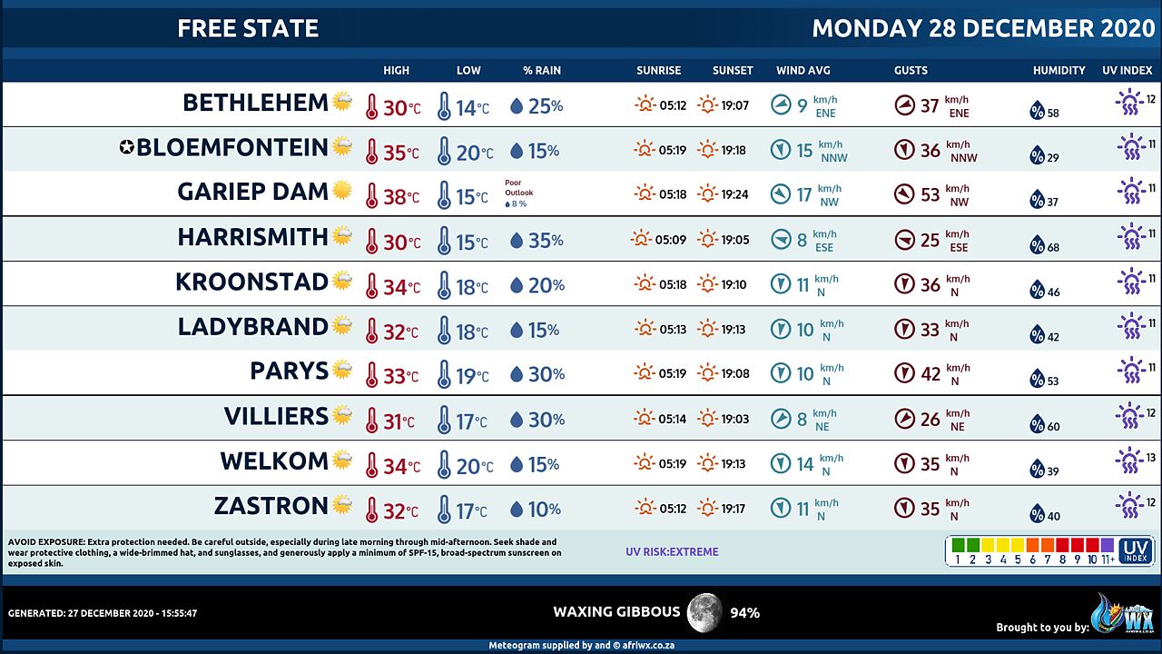
Free State Province Weather Meteogram Monday 28 December 2020
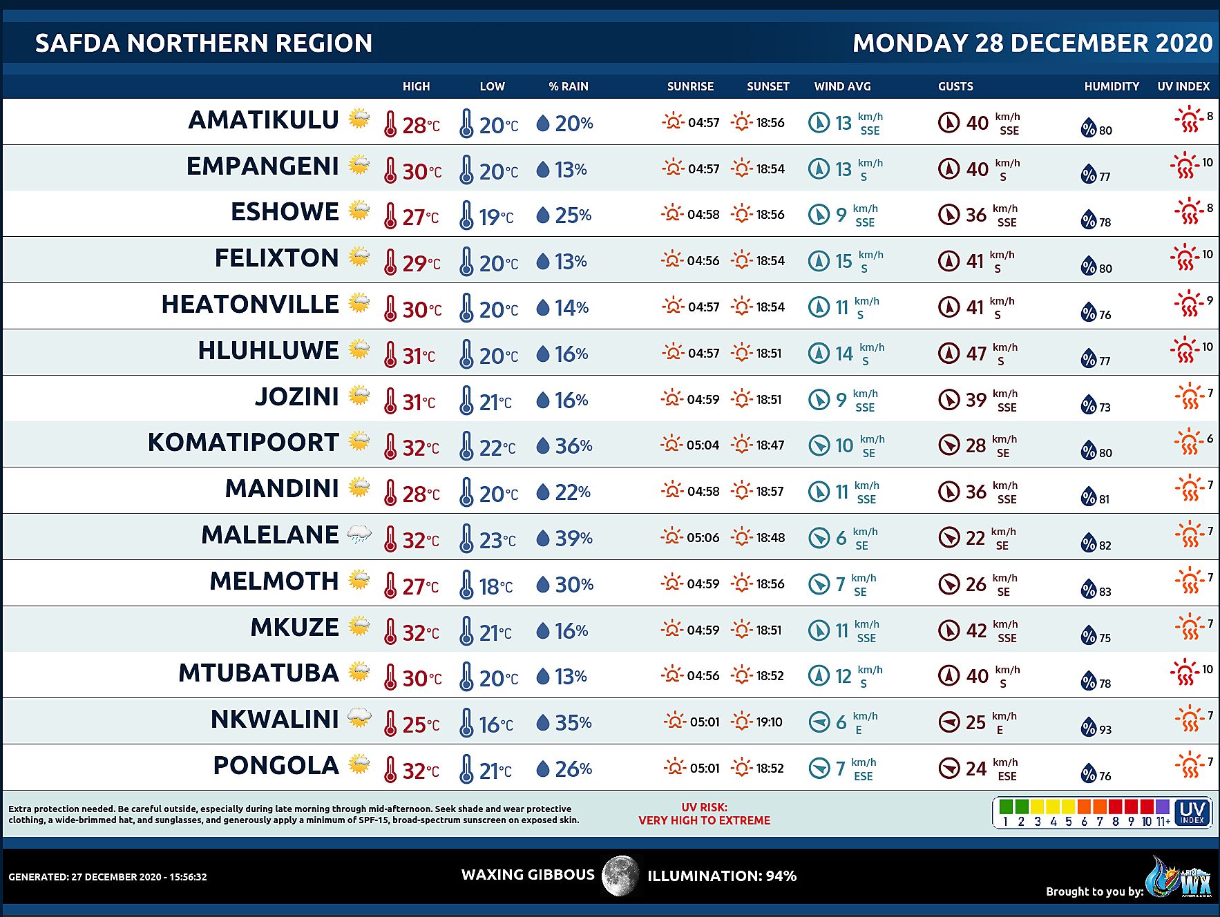
SAFDA Sugar Cane Farming (Northern Kwazulu-Natal) Weather Forecast Monday 28 December 2020
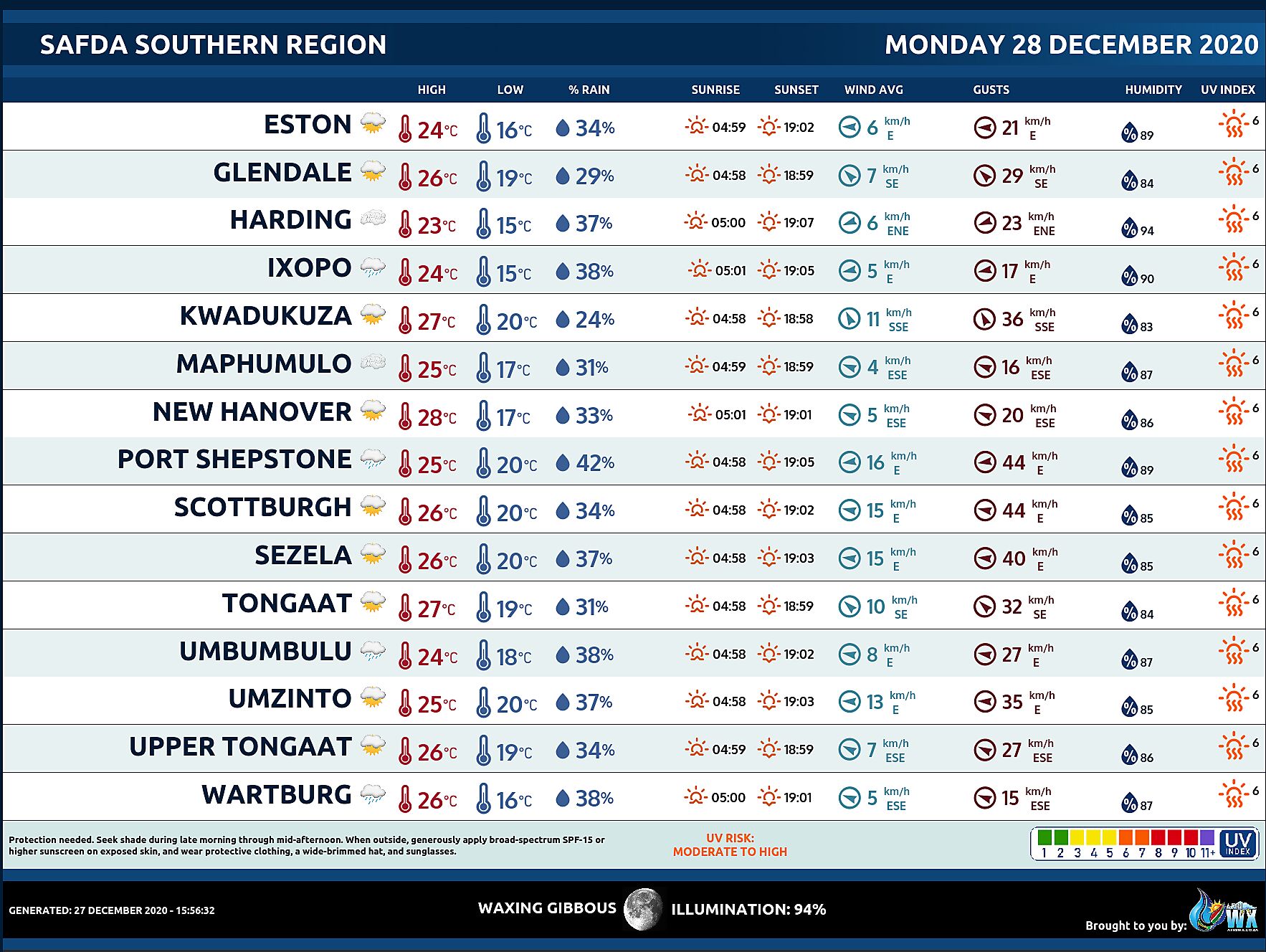
SAFDA Sugar Cane Farming (Southern Kwazulu-Natal) Weather Forecast Monday 28 December 2020
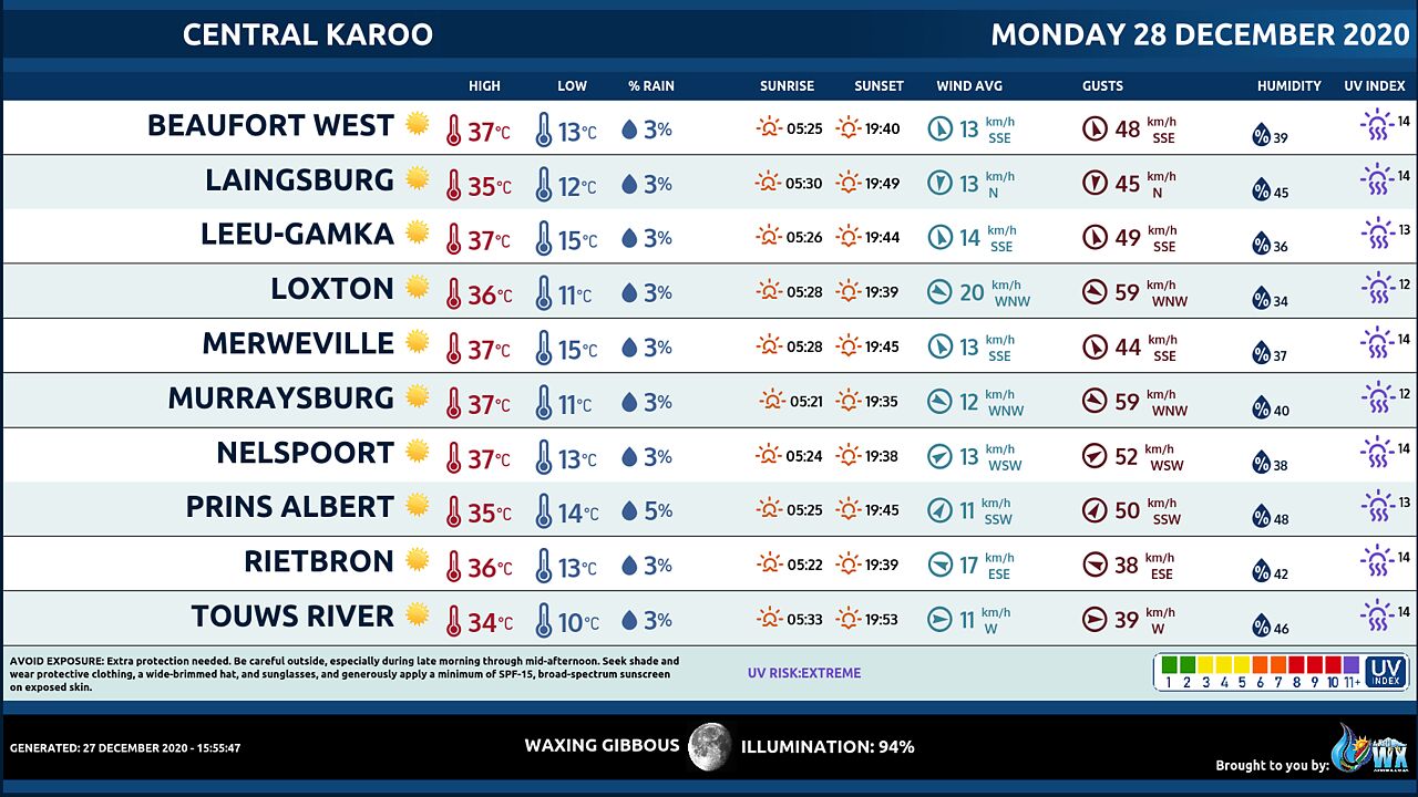
Central Karoo (Northern Cape) Farming Weather Forecast Monday 28 December 2020
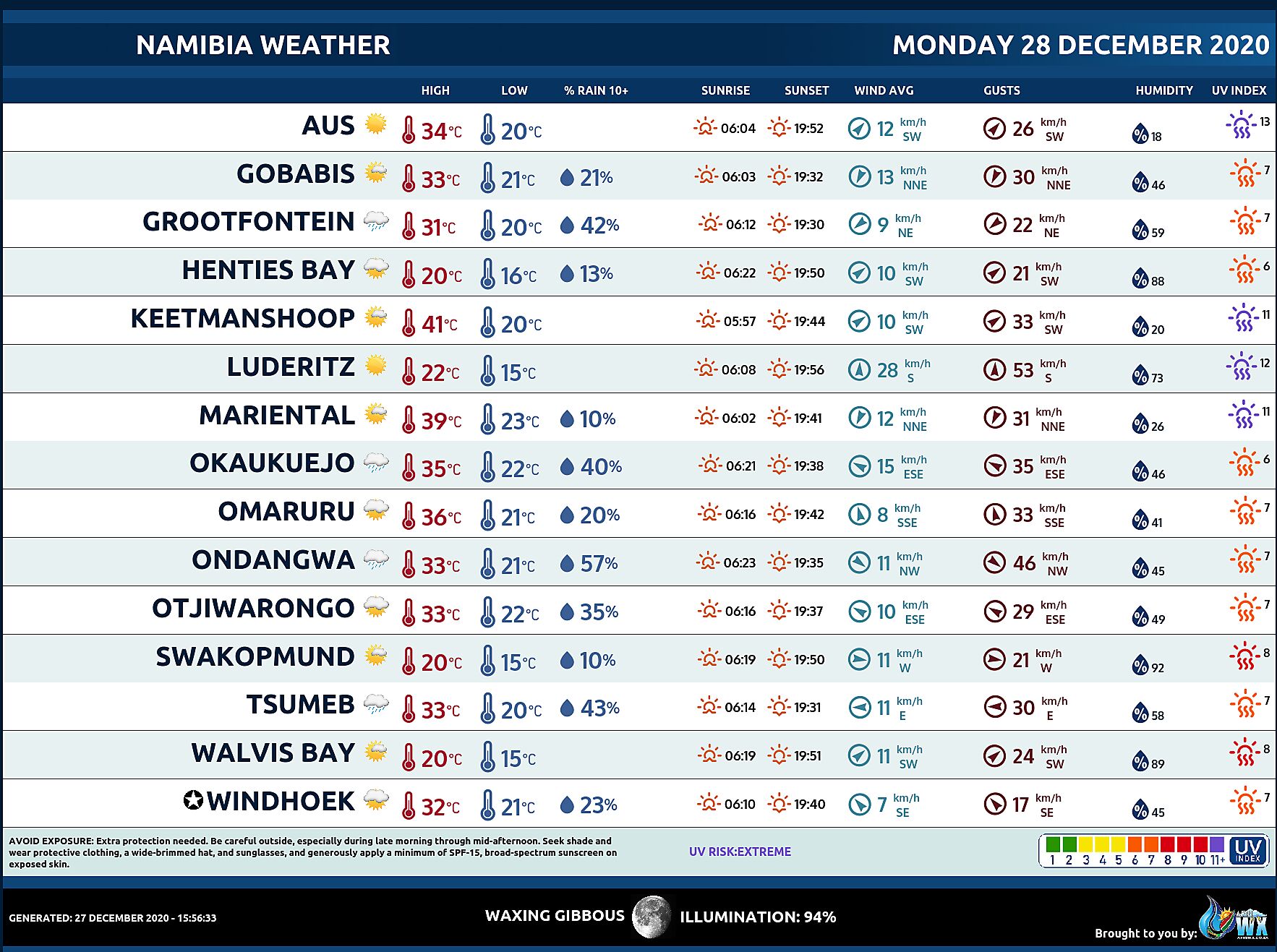
Namibia Meteorological Services METEONA Weather Forecast Monday 28 December 2020
Weather Maps by SAWX – Feel Free to Share
Join our free AfriWX channel on Telegram Messenger, please download Telegram for Android or iPhone if you want to always be up to date with the latest weather maps.
Click to join our Telegram Channel


