Last Updated on 27th December 2020 3:44 PM by AfriWX
THE REGIONAL WEATHER FORECAST
FOR TOMORROW 2020-07-12
ISSUED AT 1600 SAST
BY THE SOUTH AFRICAN WEATHER SERVICE.
SEVERE WEATHER ALERTS
WARNINGS
Nil.
WATCHES
Nil.
SPECIAL WEATHER ADVISORIES
1.
An intense cold front is expected to affect the Western and Northern Cape from late Sunday into Monday.
The public and small stock farmers are advised that gale force winds, heavy rain leading to flooding, very cold conditions as well as very rough seas can be expected.
2.
Heavy rain leading to flooding is expected over the Cape Metropole, western Cape Winelands and western Overberg in the Western Cape on Monday (13/07/2020).
3.
Gale to strong gale force north-westerly to westerly winds (65-90km/h) are expected between Cape Columbine and Cape Agulhas Sunday night spreading to Plettenberg Bay, as well as over the central and eastern interior of the Western Cape as well as over the Cape Metropole, Overstrand and Cape Agulhas municipalities on Monday (13/07/2020).
4.
High to very high seas with wave heights between 6-10m is expected between Lambert’s Bay and Plettenberg Bay on Monday, subsiding from the west on Tuesday (13-14/07/2020).
5.
Very cold conditions are expected in places over the high-lying areas of the Namakwa District in the Northern Cape until Tuesday and Western Cape and Eastern Cape high ground on Monday and Tuesday (11-14/07/2020).
6.
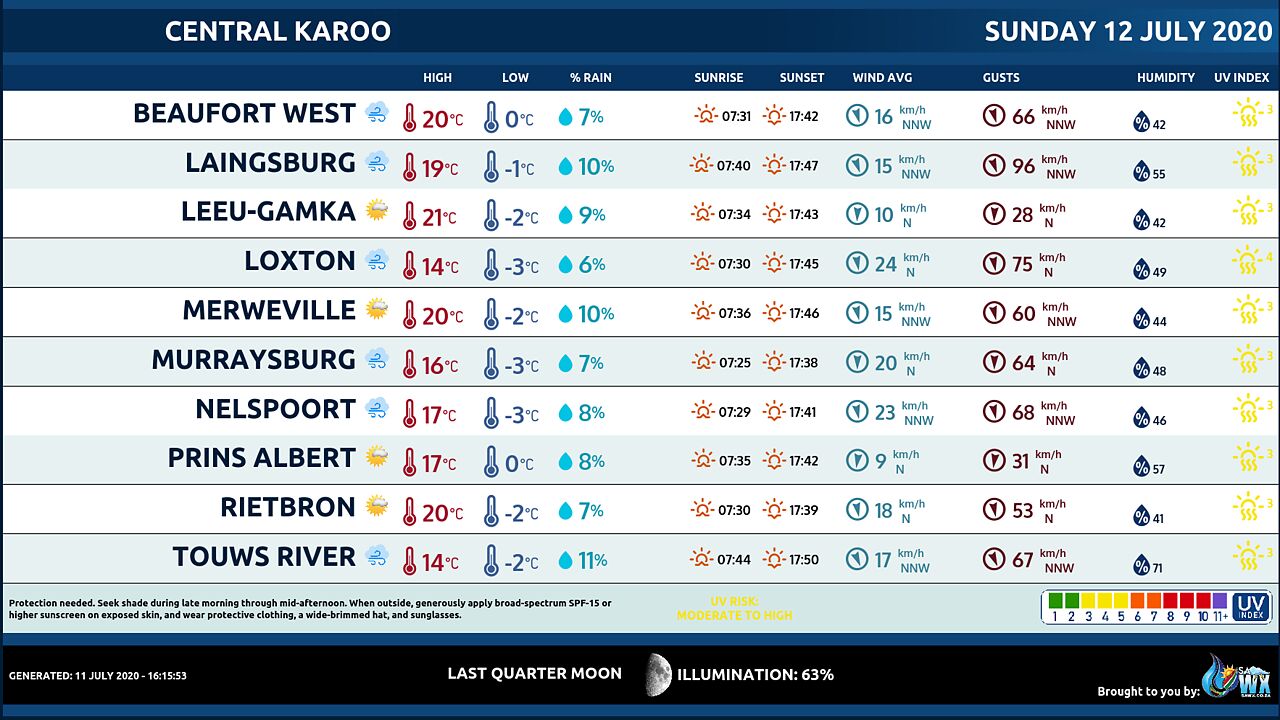
Strong interior winds (45-55km/h) can be expected over the Namakwa interior of the Northern Cape, Central Karoo and Breede River Valley in the Western Cape Sunday, spreading to the interior of the Eastern Cape on Monday.
7.
Light snowfalls is possible over the western mountains in the Western Cape and southern high ground of the Northern Cape on Monday into Tuesday (13-14/07/2020).
PROVINCIAL WEATHER OVERVIEW
GAUTENG PROVINCE
Fine and cold.
The expected UVB sunburn Index Low
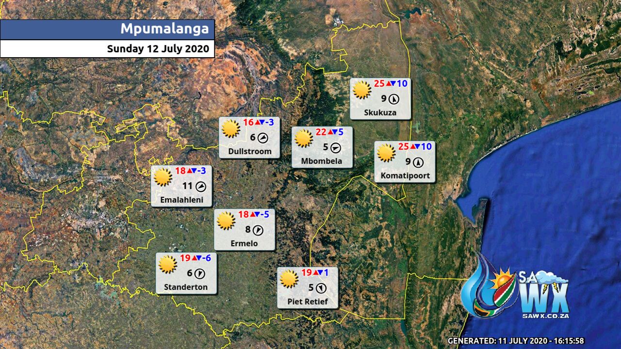
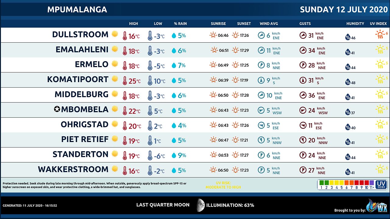
MPUMALANGA PROVINCE
Fine and cool but cold along the escarpment and southern Highveld.
Private Bag X097, Pretoria, 0001 • Tel + 27 (0) 12 367 6000 • www.
weathersa.
co.
za • USSD *120*7297#
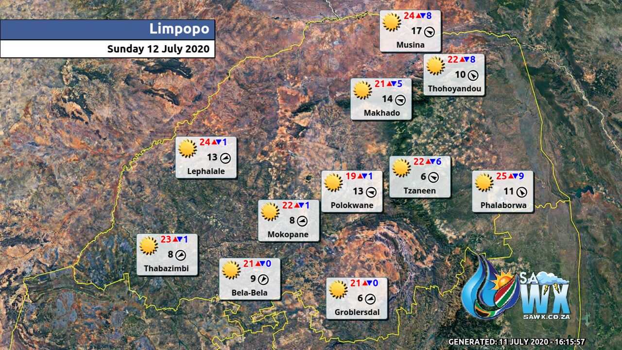
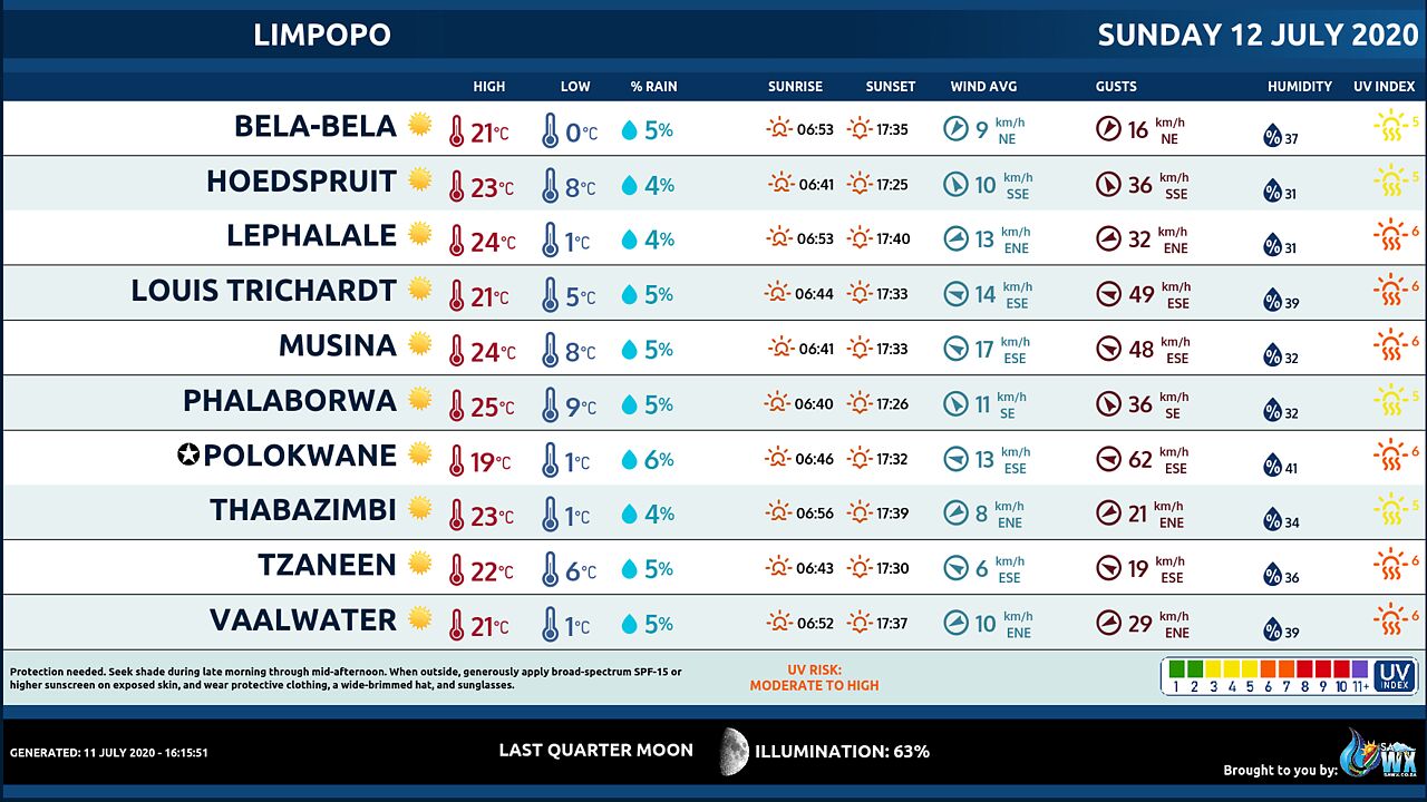
LIMPOPO PROVINCE
Fine and cool.
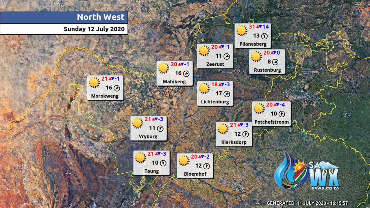
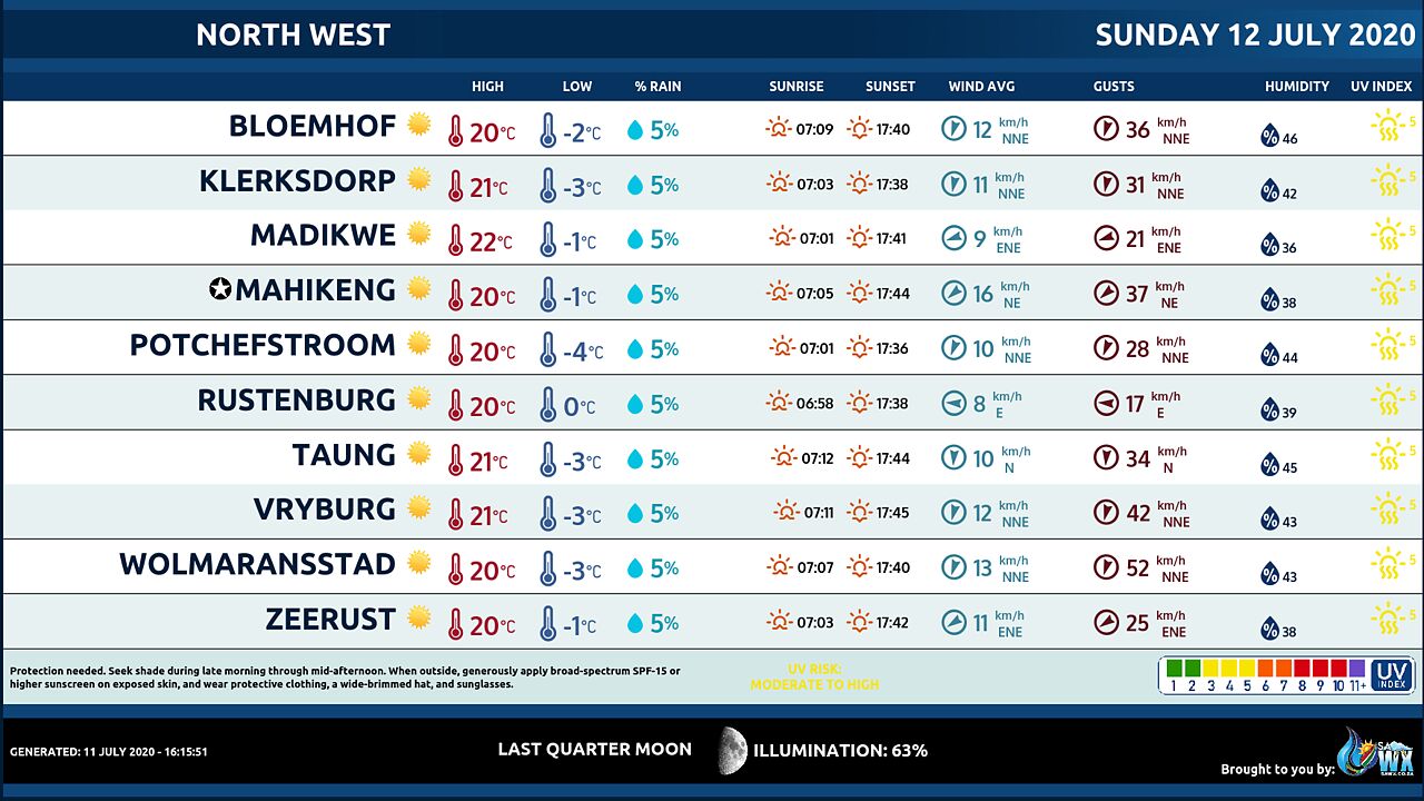
NORTH-WEST PROVINCE
Very cold at first with severe frost, fine and cold.
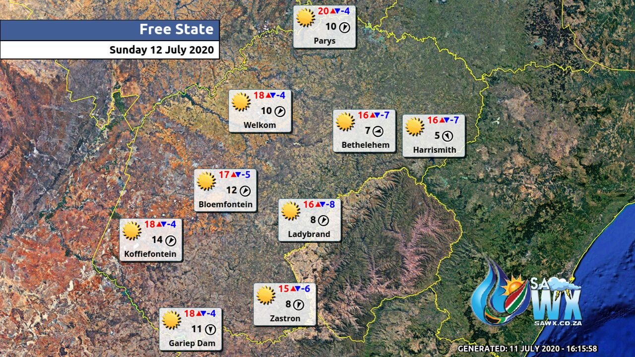
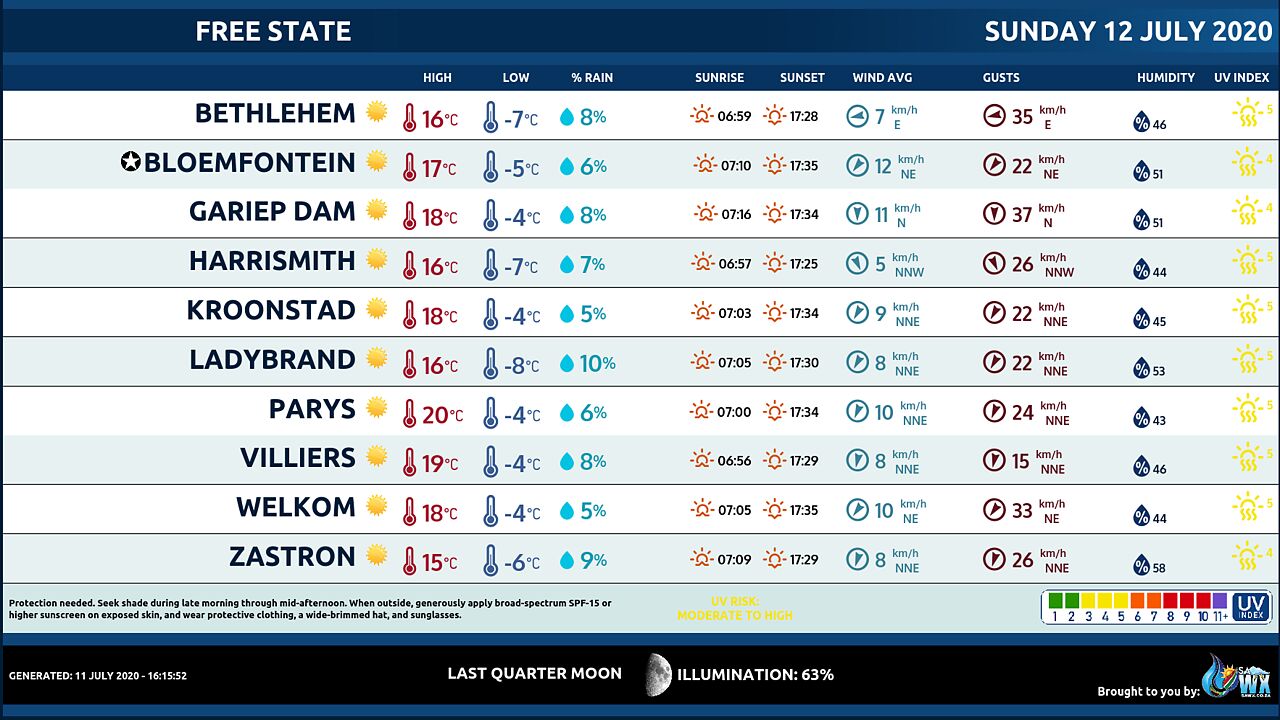
FREE STATE
Fine and cold to very cold with severe frost at first.
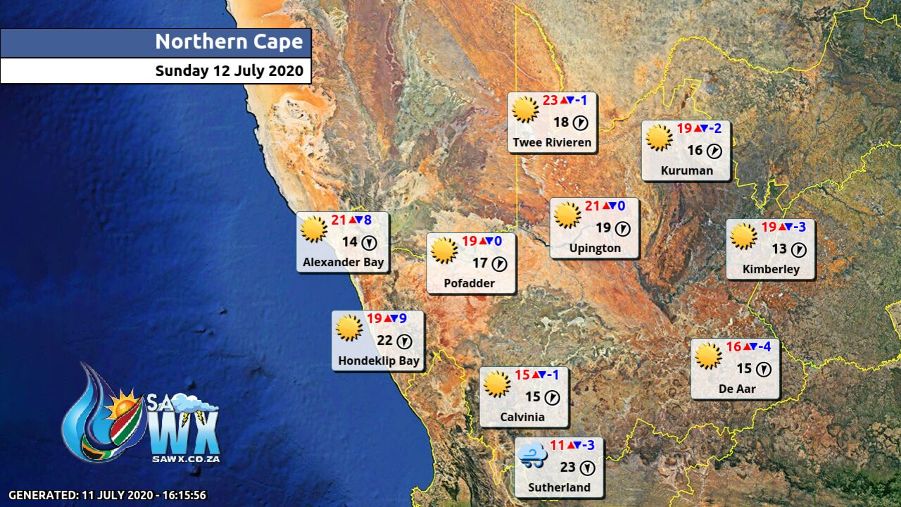
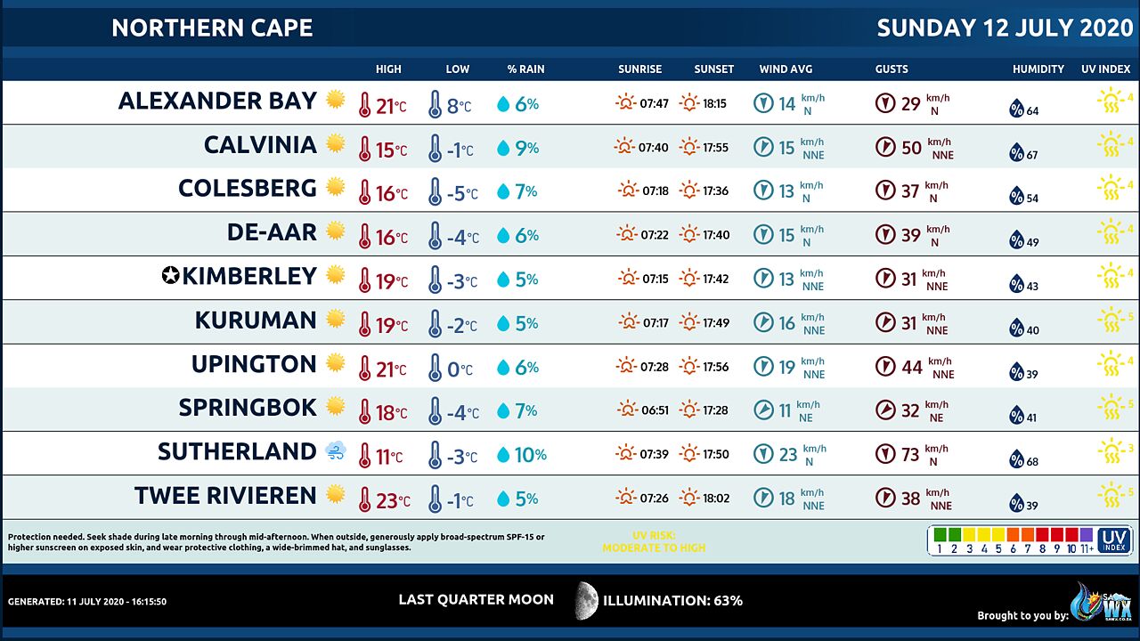
NORTHERN CAPE
Frosty areas at first otherwise fine and cold but very cold over the southern ground.
Ii will be windy over the interior from afternoon through to the evening.
The wind along the coast will be moderate to fresh easterly to north-easterly becoming westerly in the afternoon.
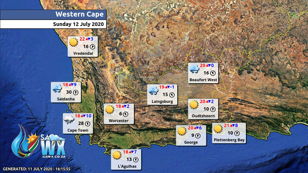
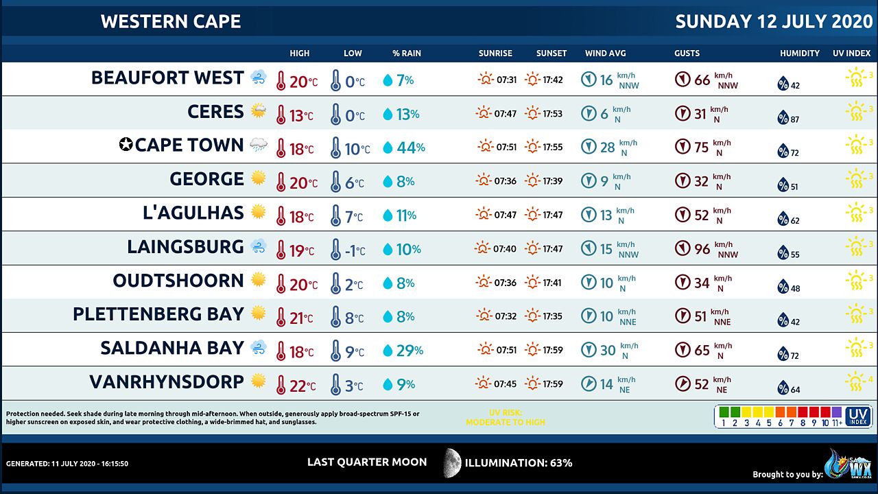
WESTERN CAPE
Frosty in places over the interior at first otherwise sunny and cool to cold becoming partly cloudy over the extreme west and south western parts from late evening.
It will become windy over the Central Karoo, Breede Valley and Cape Metropole by afternoon.
The wind along the coast will be moderate to fresh northerly to north-easterly becoming strong north-westerly in the southwest by afternoon and reaching gale force from late evening.
The expected UVB sunburn Index Low
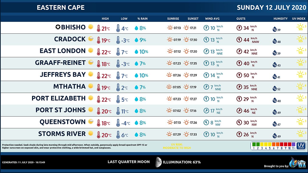
WESTERN HALF OF THE EASTERN CAPE
Cool along the coast, otherwise fine and cold.
Frost can be expected in places over the high lying areas in the morning.
The wind along the coast will be Light north westerly, becoming moderate north easterly by late morning, but fresh in places in the afternoon.
EASTERN HALF OF THE EASTERN CAPE
Partly cloudy and cool along the coast in the morning, otherwise fine and cold but very cold in places in the north.
Frost can be expected in places over the high lying areas in the morning.
The wind along the coast will be Moderate north westerly, becoming fresh north easterly from late morning, but strong in the evening.
KWAZULU-NATAL
Partly cloudy in the east, otherwise fine and cool to cold.
The wind along the coast will be Moderate to fresh southerly to south-easterly becoming easterly to north-easterly south of Durban by the afternoon.
The expected UVB sunburn Index Low Private Bag X097, Pretoria, 0001 • Tel + 27 (0) 12 367 6000 • www.
weathersa.
co.
za • USSD *120*7297#
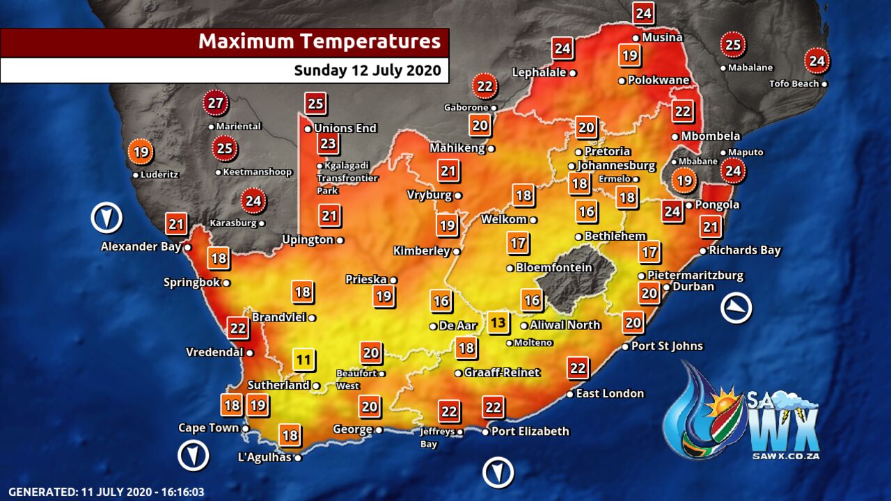
Maximum Temperatures Forecast for South Africa Sunday 12 July 2020
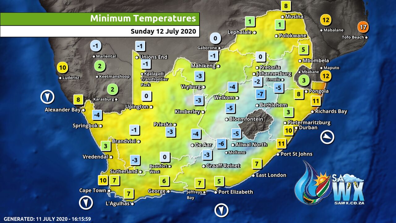
Minimum Temperatures Forecast for South Africa Sunday 12 July 2020
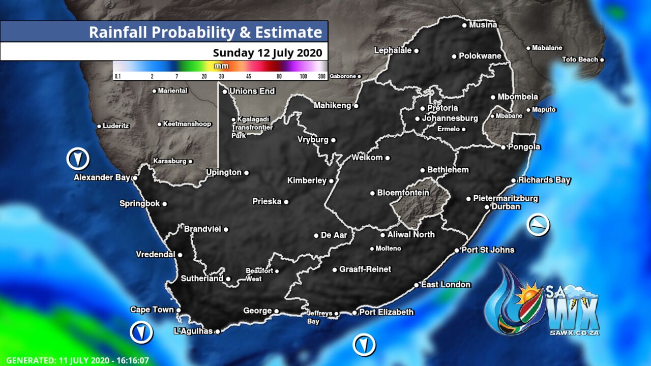
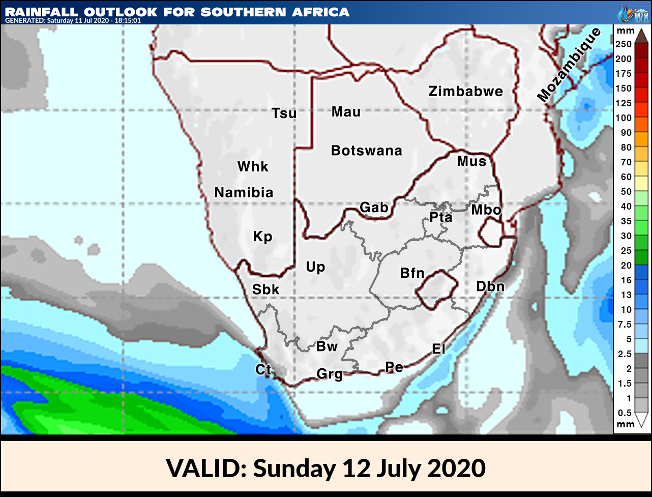
Rainfall Outlook for South Africa Sunday 12 July 2020
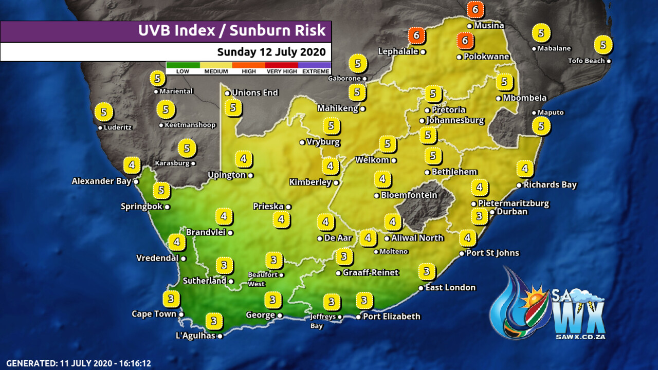
UVB Index Outlook for South Africa Sunday 12 July 2020
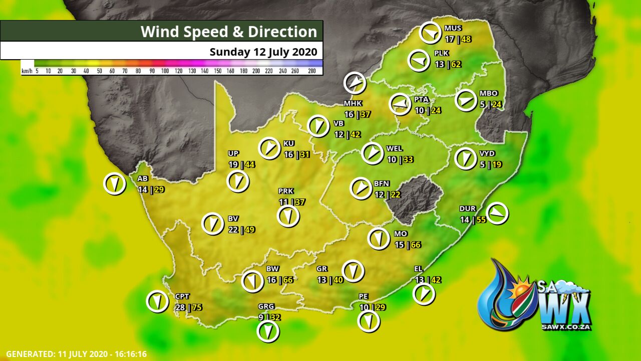
Wind Speed Direction and Gusts Map for South Africa Sunday 12 July 2020
TRAVELLERS WEATHER FORECAST
FOR TOMORROW 2020-07-12
ISSUED AT 1530 SAST
BY THE SOUTH AFRICAN WEATHER SERVICE.
SEVERE WEATHER ALERTS
WARNINGS
Nil.
WATCHES
Nil.
SPECIAL WEATHER ADVISORIES
– 1.
An intense cold front is expected to affect the Western and Northern Cape from late Sunday into Monday.
The public and small stock farmers are advised that gale force winds, heavy rain leading to flooding, very cold conditions as well as very rough seas can be expected.
2.
Heavy rain leading to flooding is expected over the Cape Metropole, western Cape Winelands and western Overberg in the Western Cape on Monday (13/07/2020).
3.
Gale to strong gale force north-westerly to westerly winds (65-90km/h) are expected between Cape Columbine and Cape Agulhas Sunday night spreading to Plettenberg Bay, as well as over the central and eastern interior of the Western Cape as well as over the Cape Metropole, Overstrand and Cape Agulhas municipalities on Monday (13/07/2020).
4.
High to very high seas with wave heights between 6-10m is expected between Lambert’s Bay and Plettenberg Bay on Monday, subsiding from the west on Tuesday (13-14/07/2020).
5.
Very cold conditions are expected in places over the high-lying areas of the Namakwa District in the Northern Cape until Tuesday and Western Cape and Eastern Cape high ground on Monday and Tuesday (11-14/07/2020).
6.
Strong interior winds (45-55km/h) can be expected over the Namakwa interior of the Northern Cape, Central Karoo and Breede River Valley in the Western Cape Sunday, spreading to the interior of the Eastern Cape on Monday.
7.
Light snowfalls is possible over the western mountains in the Western Cape and southern high ground of the Northern Cape on Monday into Tuesday (13-14/07/2020).
WEATHER IN OUR TOP CITIES
PRETORIA
Fine.
Minimum/Maximum 3/17 The expected UVB Sunburn Index Low
JOHANNESBURG
Private Bag X097, Pretoria, 0001 • Tel + 27 (0) 12 367 6000 • www.
weathersa.
co.
za • USSD *120*7297# Fine.
Minimum/Maximum 2/15
VEREENIGING
– Fine.
Minimum/Maximum -1/17
MBOMBELA
Fine.
Minimum/Maximum 9/17
POLOKWANE
– Fine.
Minimum/Maximum 6/18
MAHIKENG
Fine.
Minimum/Maximum 0/16
VRYBURG
Fine.
Minimum/Maximum -2/17
BLOEMFONTEIN
Fine.
Minimum/Maximum -6/13
KIMBERLEY
– Fine.
Minimum/Maximum -5/19
UPINGTON
Fine.
Minimum/Maximum 1/18
CAPE TOWN
– Fine with traces of high level cloud at first becoming cloudy from late evening.
Wind Moderate northerly becoming strong in the late afternoon.
Private Bag X097, Pretoria, 0001 • Tel + 27 (0) 12 367 6000 • www.
weathersa.
co.
za • USSD *120*7297# Minimum/Maximum 8/17 The expected UVB Sunburn Index Low
GEORGE
Fine.
Wind Light northerly Minimum/Maximum 6/18
PORT ELIZABETH
– Fine.
Wind Light north westerly in the morning, otherwise moderate north easterly.
Minimum/Maximum 7/19
EAST LONDON
– Partly cloudy in the morning, otherwise fine.
Wind Moderate north westerly, becoming fresh north easterly from late morning, but strong in the evening.
Minimum/Maximum 11/19
DURBAN
Partly cloudy, becoming fine in the late afternoon.
Wind Moderate to fresh southerly to south-easterly becoming easterly to north-easterly in the afternoon.
Minimum/Maximum 12/18 The expected UVB Sunburn Index Low
RICHARDS BAY
Partly cloudy Wind Moderate to fresh southerly to south-easterly.
Minimum/Maximum 14/19
PIETERMARITZBURG
Fine.
Minimum/Maximum 4/16
Rainfall Outlook for Tomorrow Sunday 12 July 2020
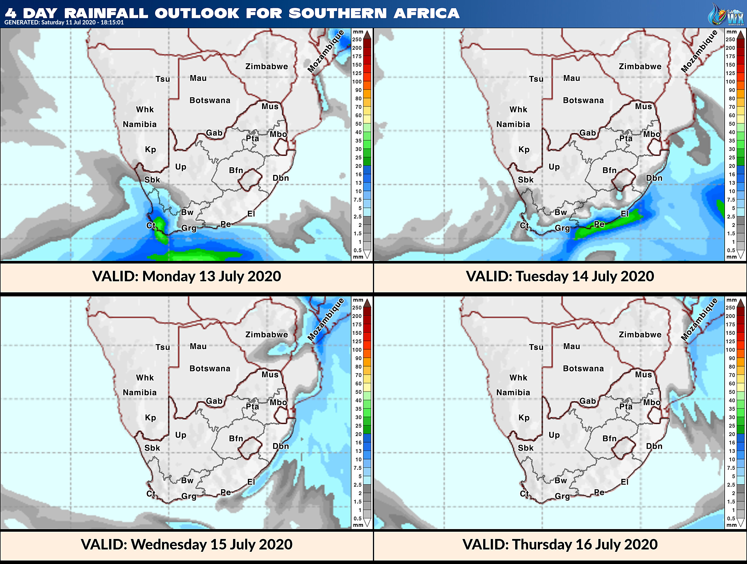
4 Day Rainfall Outlook for Southern Africa
14 Day Rainfall Outlook for Southern Africa
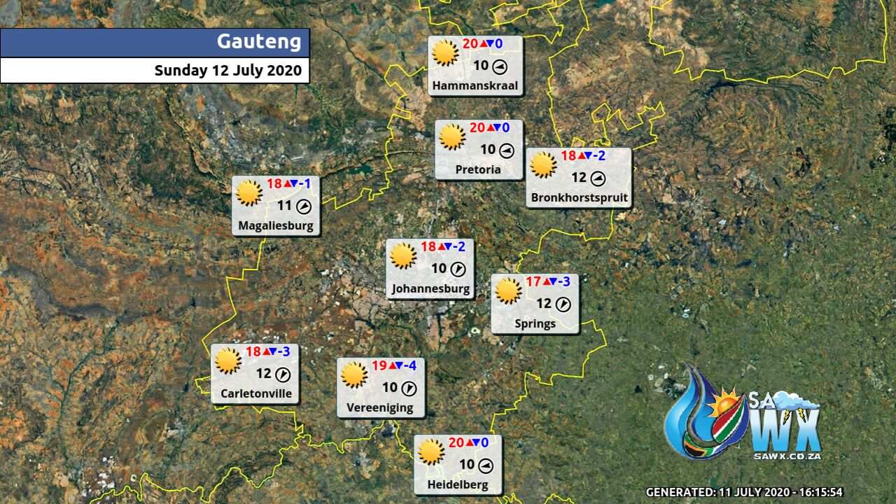
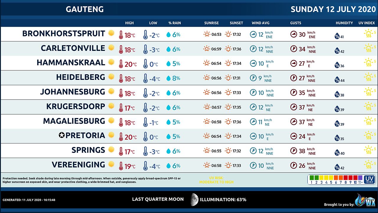
Gauteng Province Weather Map Sunday 12 July 2020
Gauteng Province Weather Meteogram Sunday 12 July 2020
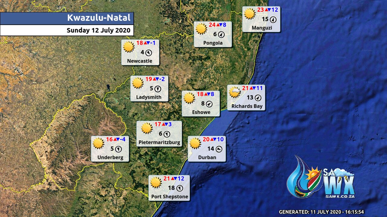
Kwazulu-Natal Province Weather Map Sunday 12 July 2020
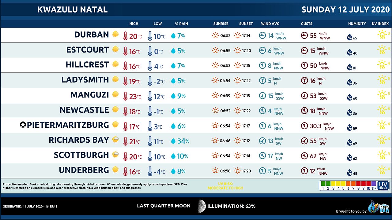
Kwazulu-Natal Province Weather Meteogram Sunday 12 July 2020
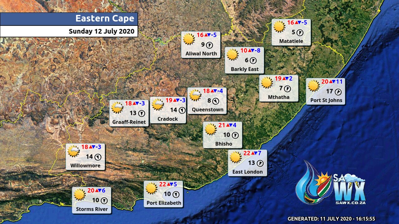
Eastern Cape Province Weather Map Sunday 12 July 2020
Eastern Cape Province Weather Meteogram Sunday 12 July 2020
Western Cape Province Weather Map Sunday 12 July 2020
Western Cape Province Weather Meteogram Sunday 12 July 2020
Northern Cape Province Weather Map Sunday 12 July 2020
Northern Cape Province Weather Meteogram Sunday 12 July 2020
North-West Province Weather Map Sunday 12 July 2020
North-West Province Weather Meteogram Sunday 12 July 2020
Limpopo Province Weather Map Sunday 12 July 2020
Limpopo Province Weather Meteogram Sunday 12 July 2020
Mpumalanga Province Weather Map Sunday 12 July 2020
Mpumalanga Province Weather Meteogram Sunday 12 July 2020
Free State Province Weather Map Sunday 12 July 2020
Free State Province Weather Meteogram Sunday 12 July 2020
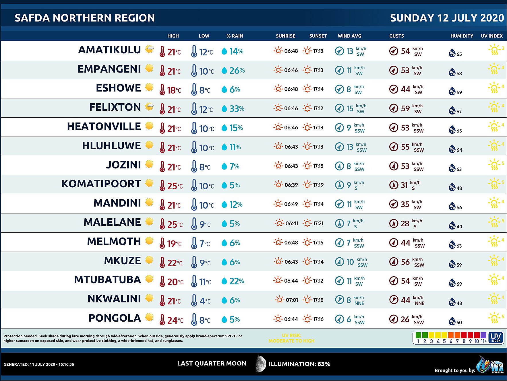
SAFDA Sugar Cane Farming (Northern Kwazulu-Natal) Weather Forecast Sunday 12 July 2020
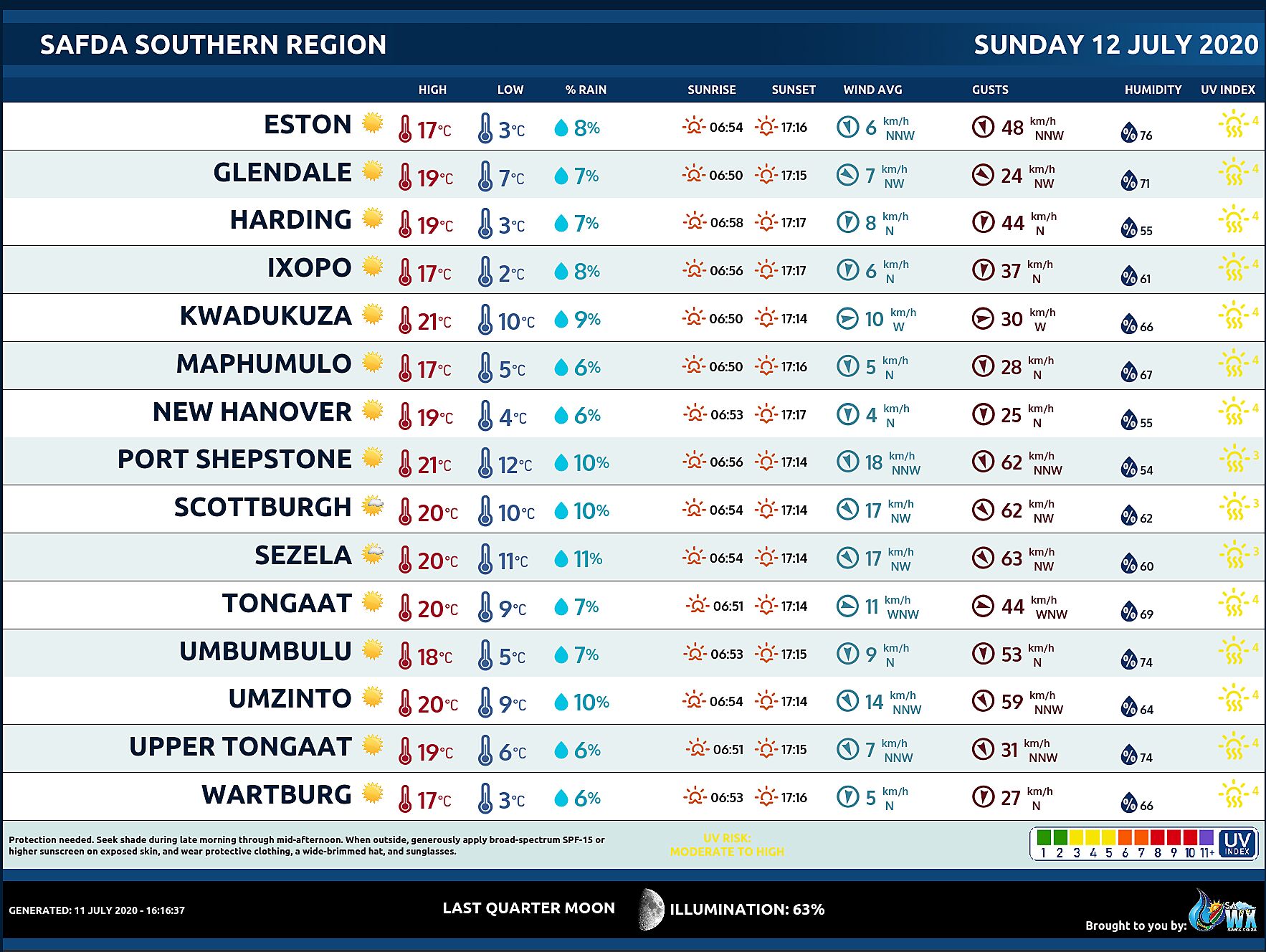
SAFDA Sugar Cane Farming (Southern Kwazulu-Natal) Weather Forecast Sunday 12 July 2020
Central Karoo (Northern Cape) Farming Weather Forecast Sunday 12 July 2020
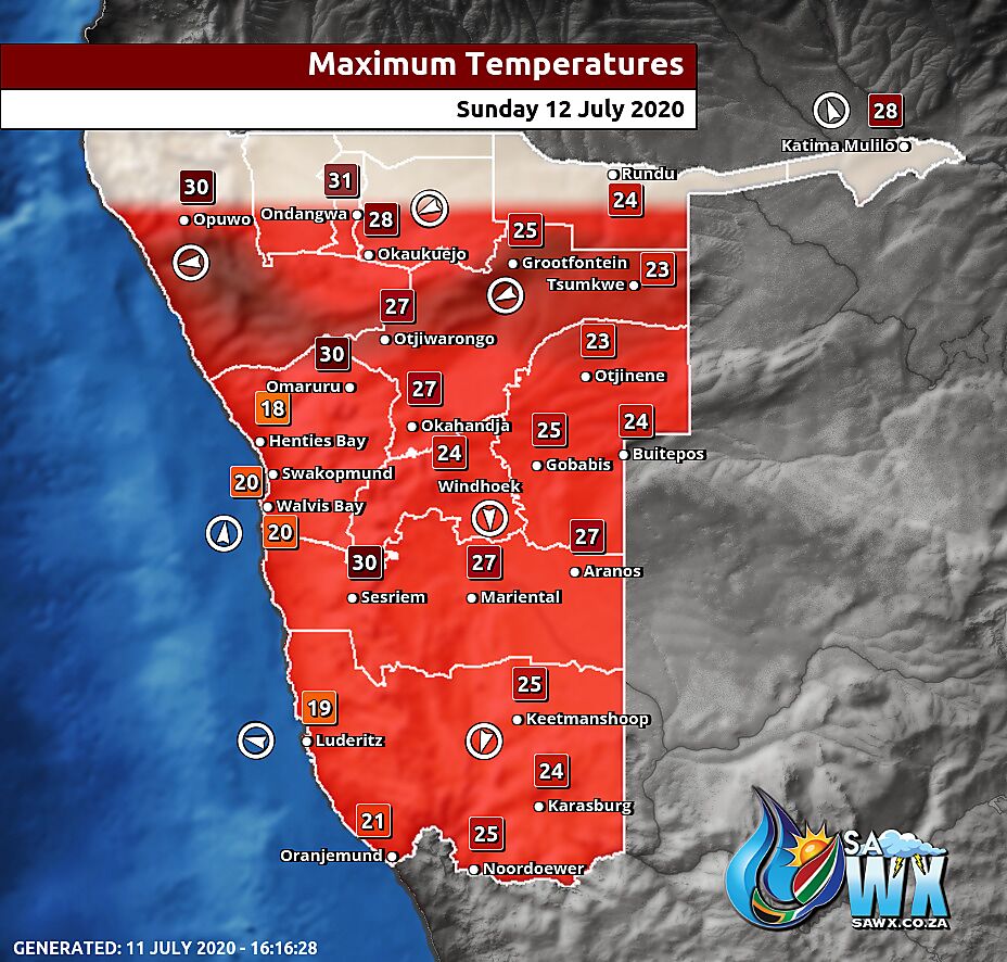
Namibia Maximum Temperatures Sunday 12 July 2020
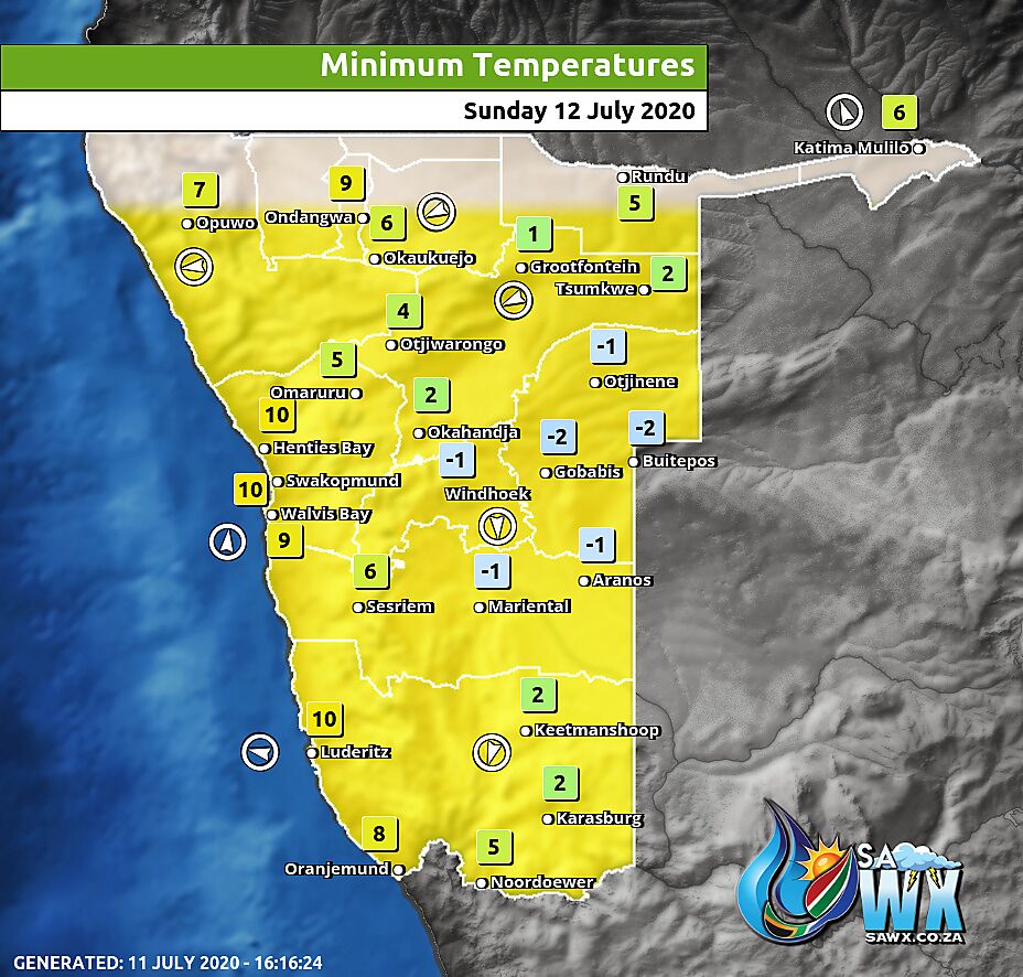
Namibia Minimum Temperatures Sunday 12 July 2020
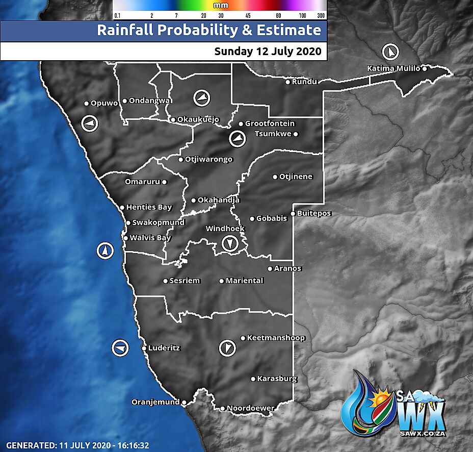
Namibia Rainfall Probability Map Sunday 12 July 2020
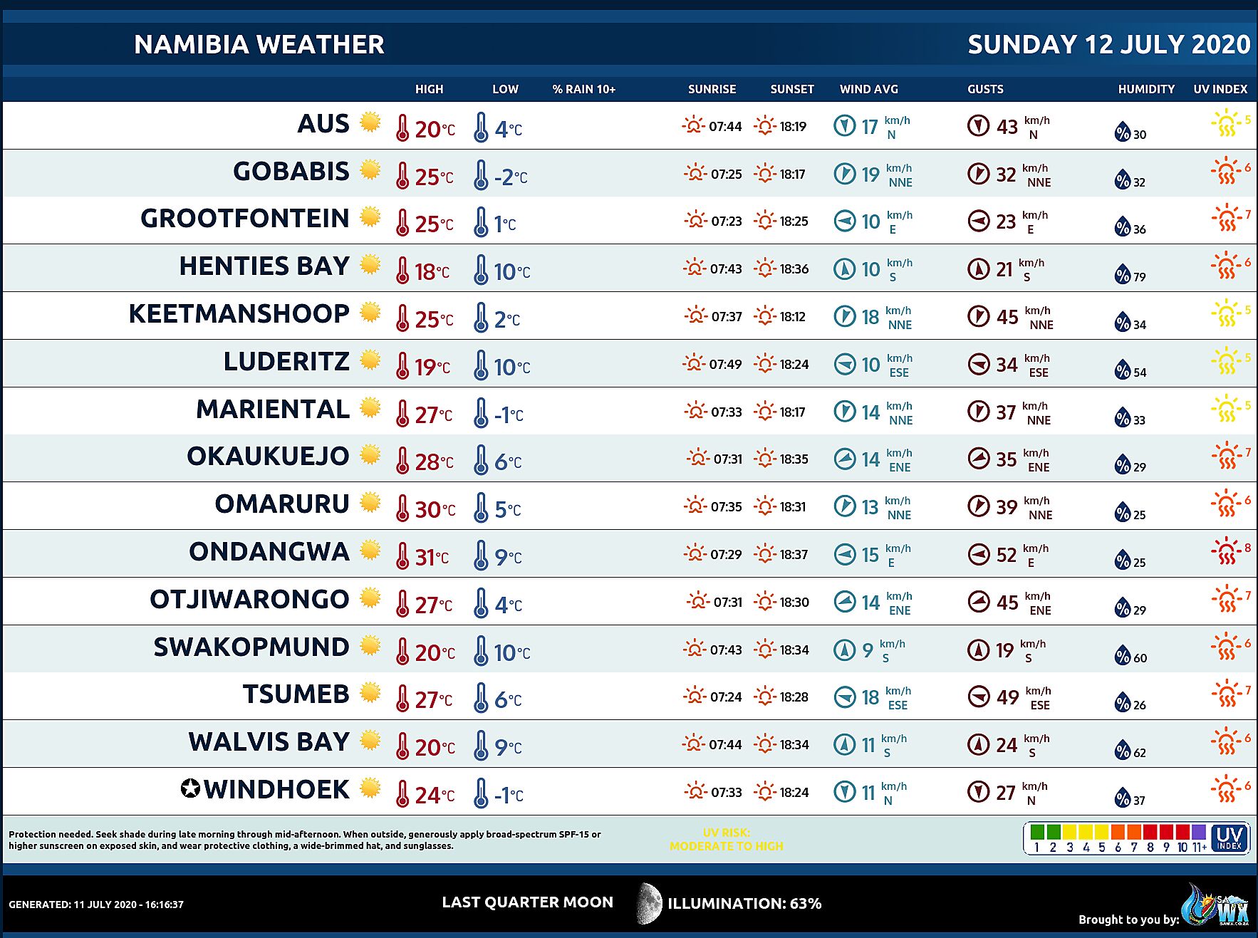
Namibia Weather Meteogram Sunday 12 July 2020
Namibia Meteorological Services METEONA Weather Forecast Sunday 12 July 2020
Weather Maps by SAWX – Feel Free to Share

