Last Updated on 27th December 2020 3:44 PM by AfriWX
THE REGIONAL WEATHER FORECAST
FOR TOMORROW 2020-06-11
ISSUED AT 1600 SAST
BY THE SOUTH AFRICAN WEATHER SERVICE.
SEVERE WEATHER ALERTS
WARNINGS
1.
Extremely high fire danger conditions expected over the north-eastern parts of the Western Cape and the Eastern Cape, except along the south-coast.
2.
A gale force NW`ly winds between Cape Columbine and Plettenberg Bay spreading eastwards and becoming W/SW`ly to Port Edward.
3.
Strong to gale force interior winds of (55 to 75km/h) expected over the Western Cape, Eastern Cape, southern parts of the Northern Cape and the southern parts of the Free State.
4.
High seas in excess of 6.
0m expected between Table Bay and Port Edward.
5.
Heavy rainfall expected over western, central and along the Western Cape as well as along the coast of the Eastern Cape and its adjacent interior, west of East London.
6.
Disruptive snowfall expected over the southern Drakensberg.
WATCHES
Nil.
SPECIAL WEATHER ADVISORIES
Nil.
PROVINCIAL WEATHER OVERVIEW
GAUTENG PROVINCE
Morning frost in the south, otherwise fine and cool.
The expected UVB sunburn Index High
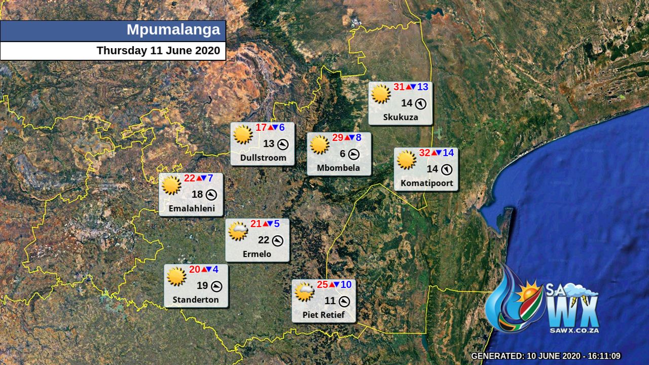
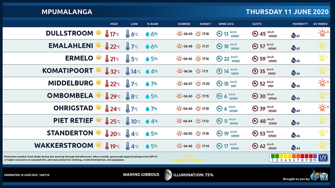
MPUMALANGA PROVINCE
Fine and cool but warm in the Lowveld.
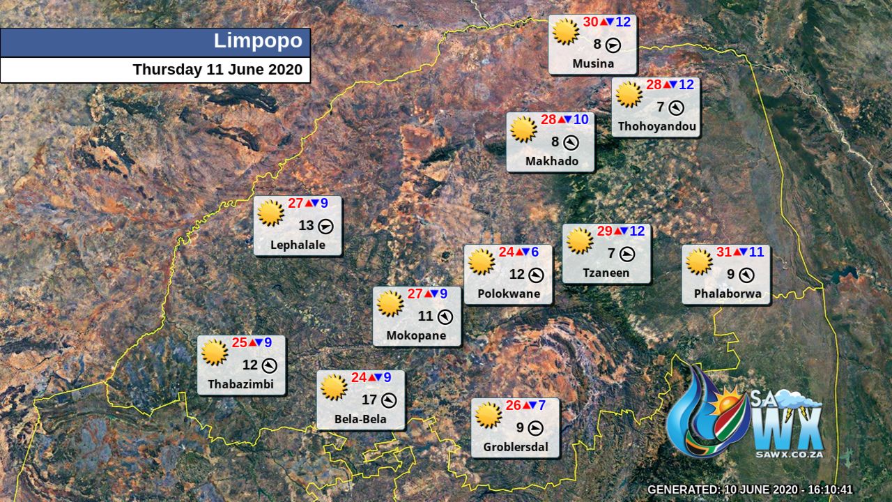
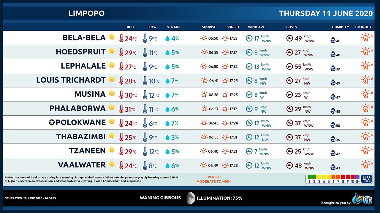
LIMPOPO PROVINCE
Fine and cool to warm.
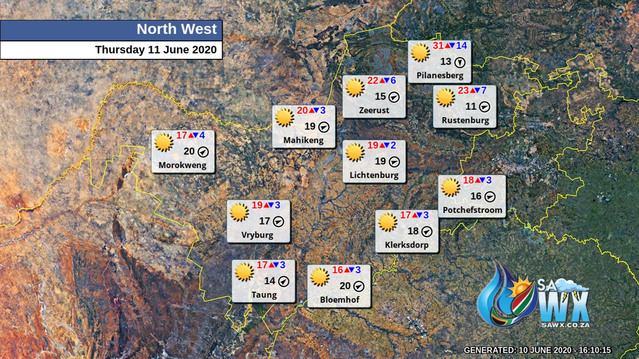
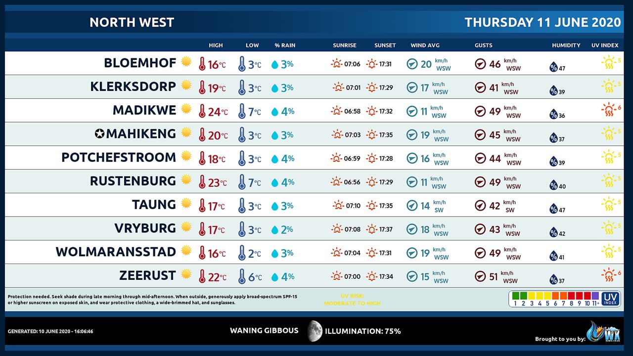
NORTH-WEST PROVINCE
Partly cloudy, windy and cold but very cold in the south.
FREE STATE
Partly cloudy, windy and cold to very cold.
Very isolated light snow showers are expected in the south.
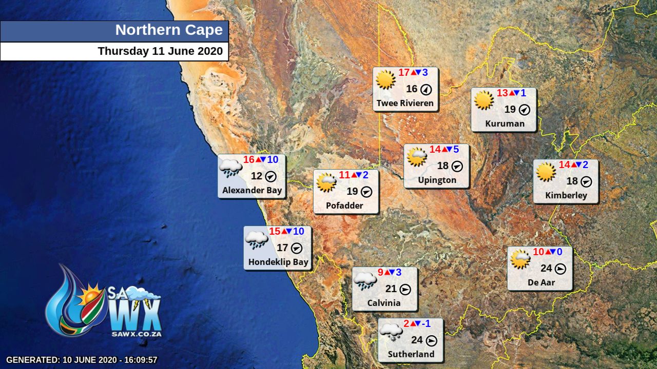
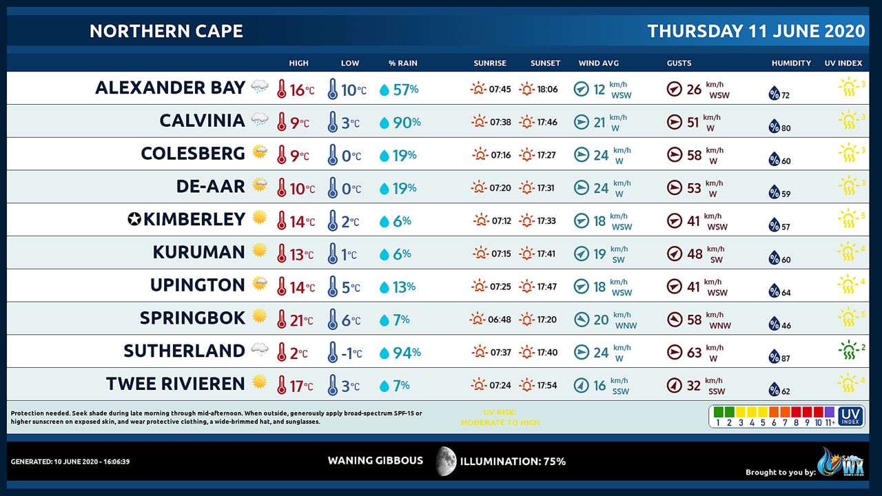
NORTHERN CAPE
Cloudy, windy and cold with scattered showers along the coast and its interior but partly cloudy with isolated light showers over the southern high ground where it will be very cold with snowfalls over the highground.
The wind along the coast will be moderate to fresh southerly to south-westerly.
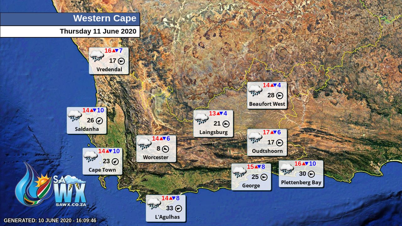
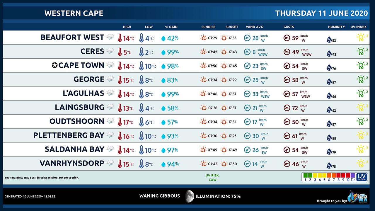
WESTERN CAPE
Cloudy and cold with scattered showers and thundershowers in the west, otherwise isolated showers and thundershowers and light to moderate snow over the western highground.
The wind along the coast will be fresh to strong southerly to south-westerly, but gale east of Cape Agulhas, moderating by the afternoon.
The expected UVB sunburn Index Low
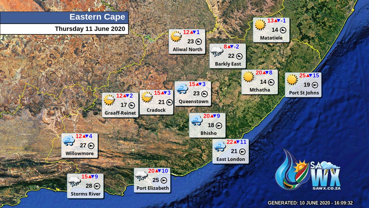
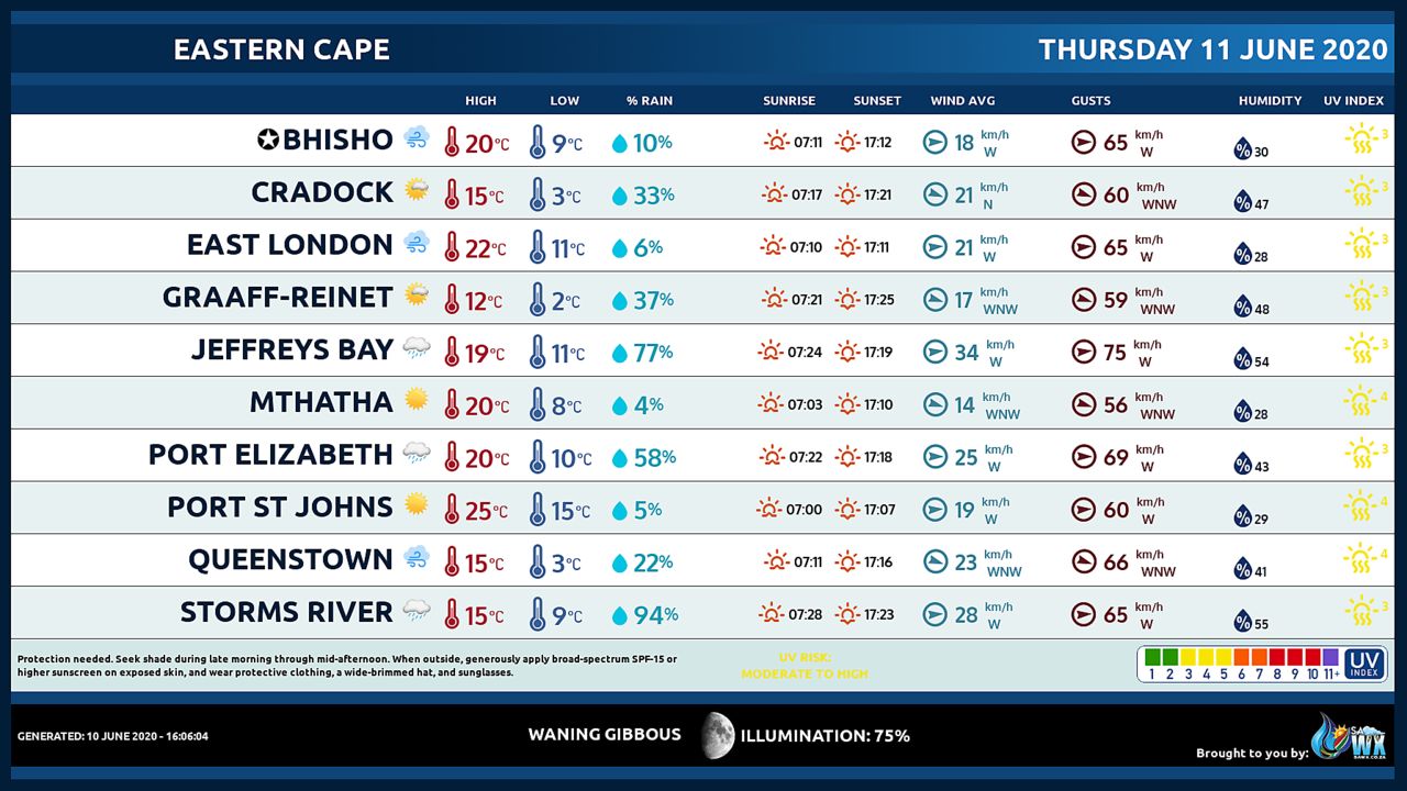
WESTERN HALF OF THE EASTERN CAPE
Cloudy and cold with isolated showers but scattered along the coast and adjacent interior.
Snowfalls are expected over high lying areas.
The wind along the coast will be fresh to strong westerly, reaching gale force east of Tsitsikamma coast in the afternoon.
EASTERN HALF OF THE EASTERN CAPE
Partly cloudy and cold but cool along the coast.
The wind along the coast will be fresh to strong westerly.
KWAZULU-NATAL
Fine and cool to warm but cold in the extreme south-west.
It will become partly cloudy in places at times.
The wind along the coast will be moderate to fresh northerly to north-easterly but moderate to fresh southerly to south-westerly spreading to the north by evening reaching strong to near gale in places at times.
The expected UVB sunburn Index Moderate
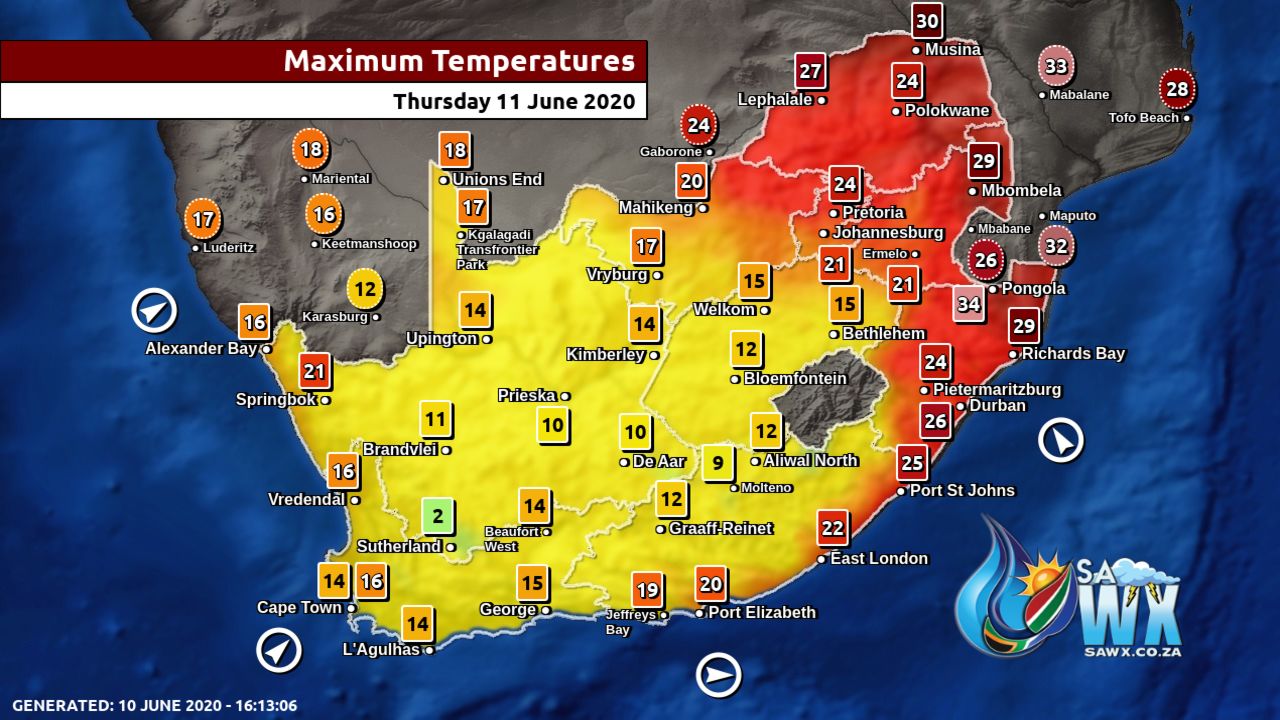
Maximum Temperatures Forecast for South Africa Thursday 11 June 2020
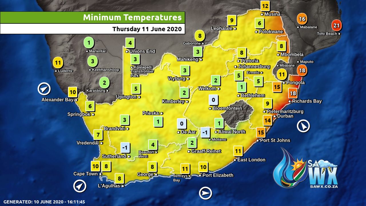
Minimum Temperatures Forecast for South Africa Thursday 11 June 2020
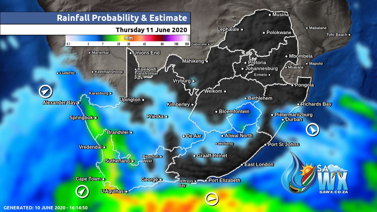
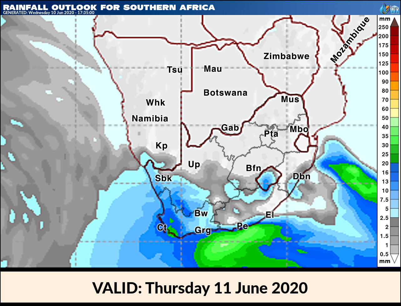
Rainfall Outlook for South Africa Thursday 11 June 2020
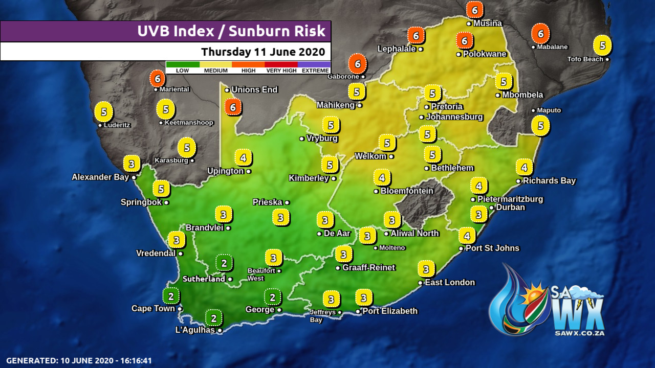
UVB Index Outlook for South Africa Thursday 11 June 2020
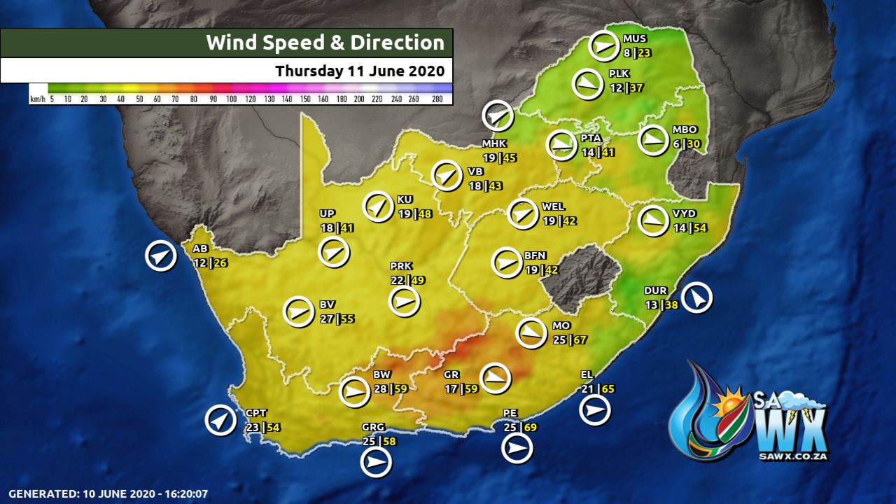
Wind Speed Direction and Gusts Map for South Africa Thursday 11 June 2020
TRAVELLERS WEATHER FORECAST
FOR TOMORROW 2020-06-10
ISSUED AT 1530 SAST
BY THE SOUTH AFRICAN WEATHER SERVICE.
SEVERE WEATHER ALERTS
WARNINGS
1.
Heavy rain leading to localized flooding is expected along the coast and adjacent interior of the Northern Cape as well as the western parts of the Western Cape.
2.
Gale force winds (60 to 65 km/h) are expected along the coast between Cape Columbine and Plettenberg Bay .
3.
Extremely high fire danger conditions are expected over the eastern parts of the Northern Cape, western parts of the Free State, western parts of the North West, the Eastern Cape as well as the extreme eastern parts of the Western Cape.
WATCHES
4.
High seas with wave heights in excess of 6m is expected between Cape Columbine and Cape Agulhas from the morning, spreading to Plettenberg Bay overnight into Thursday.
5.
Gale force winds are expected over the north eastern interior of the Western Cape, the extreme southern parts of the Northern Cape as well as the western interior of the Eastern Cape.
6.
Disruptive snowfalls are expected over the western high grounds of the Western Cape and the southern high grounds of the Northern Cape.
SPECIAL WEATHER ADVISORIES
1.
An intense cold front with an associated upper air trough is expected over the western parts of the Northern and Western Cape from Wednesday (10/06/2020) morning until Thursday evening (11/06/2020).
The public and small stock farmers are advised that very cold conditions can be expected.
WEATHER IN OUR TOP CITIES
PRETORIA
Fine.
Minimum/Maximum 5/22 The expected UVB Sunburn Index High
JOHANNESBURG
Morning frost, otherwise fine.
Minimum/Maximum 4/20
VEREENIGING
– Morning frost, otherwise fine.
Minimum/Maximum 1/20
MBOMBELA
Fine.
Minimum/Maximum 9/23
POLOKWANE
– Fine.
Minimum/Maximum 7/22
MAHIKENG
Fine.
Minimum/Maximum 6/24
VRYBURG
Fine.
Minimum/Maximum 5/24
BLOEMFONTEIN
Fine, becoming partly cloudy.
Minimum/Maximum -1/22
KIMBERLEY
– Partly cloudy.
Minimum/Maximum 2/25
UPINGTON
Partly cloudy.
Minimum/Maximum 5/22
CAPE TOWN
– Cloudy with showers and thundershowers.
Heavy rain leading to localised flooding is expected in places.
Wind Fresh to strong northerly to north-westerly.
Minimum/Maximum 14/18 The expected UVB Sunburn Index Low
GEORGE
Fine in the morning, becoming cloudy from the afternoon with showers in the evening.
Wind Fresh to strong, northerly to north-westerly.
Minimum/Maximum 12/33
PORT ELIZABETH
– Fine.
Wind Light north westerly becoming fresh westerly by midday.
Minimum/Maximum 12/26
EAST LONDON
– Fine.
Wind Light to moderate north westerly becoming south westerly by evening.
Minimum/Maximum 14/30
DURBAN
Fine.
WindModerate north-easterly.
Minimum/Maximum 14/26 The expected UVB Sunburn Index Moderate
RICHARDS BAY
Fine.
WindModerate to fresh north-easterly.
Minimum/Maximum 15/28
PIETERMARITZBURG
Fine.
Minimum/Maximum 8/26
Rainfall Outlook for Tomorrow Thursday 11 June 2020
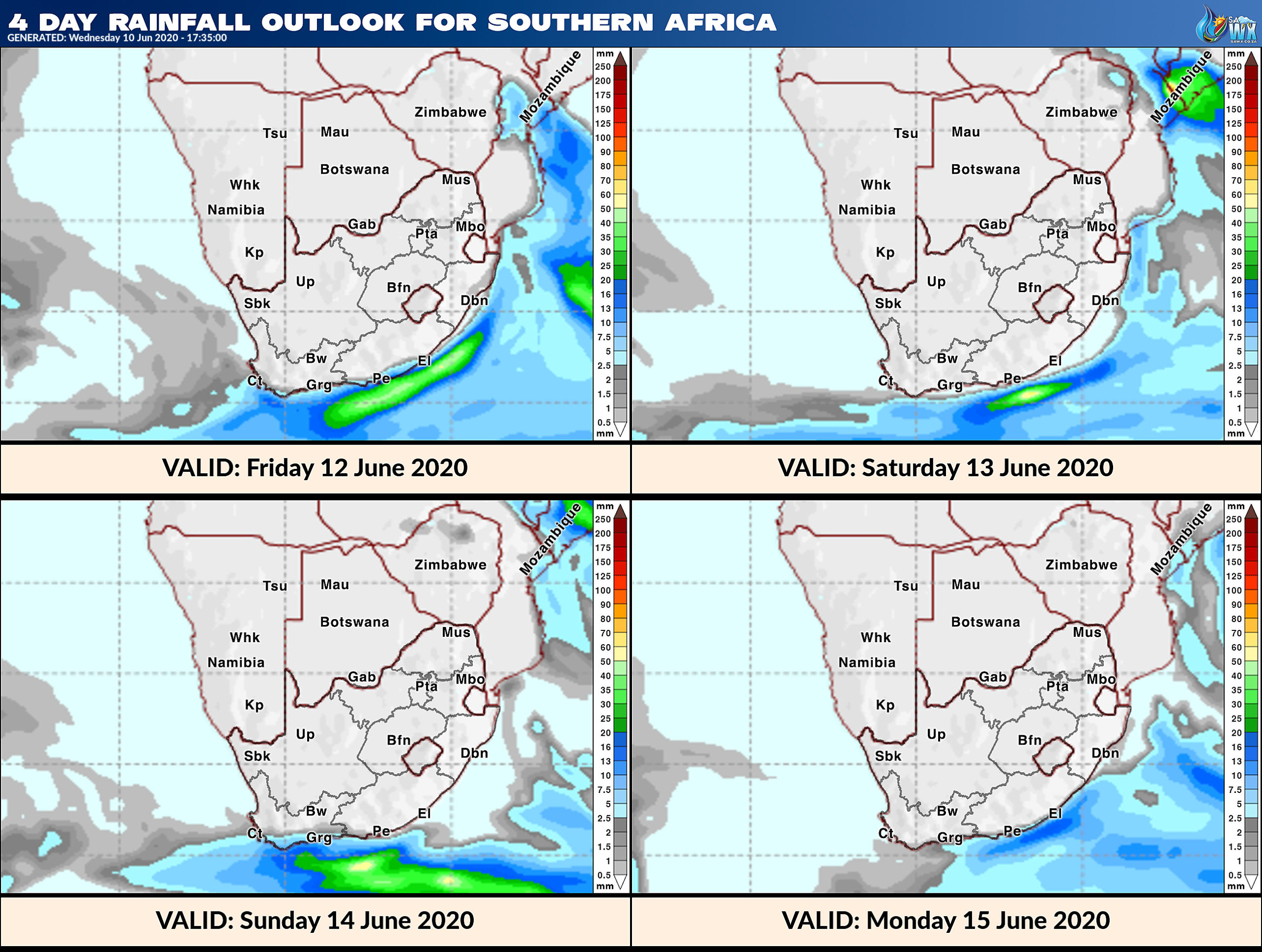
4 Day Rainfall Outlook for Southern Africa
14 Day Rainfall Outlook for Southern Africa
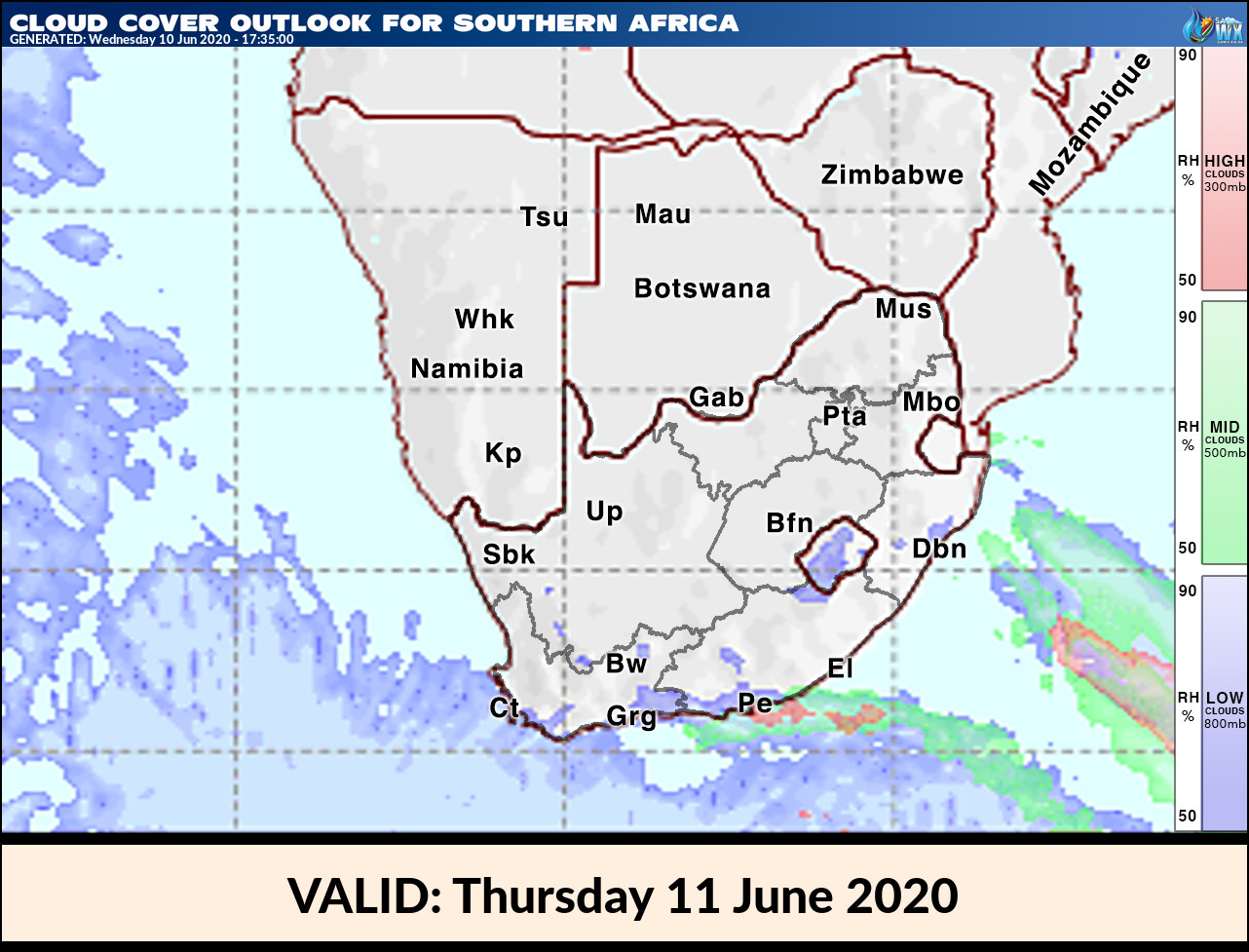
Cloud Cover Outlook for Tomorrow Thursday 11 June 2020
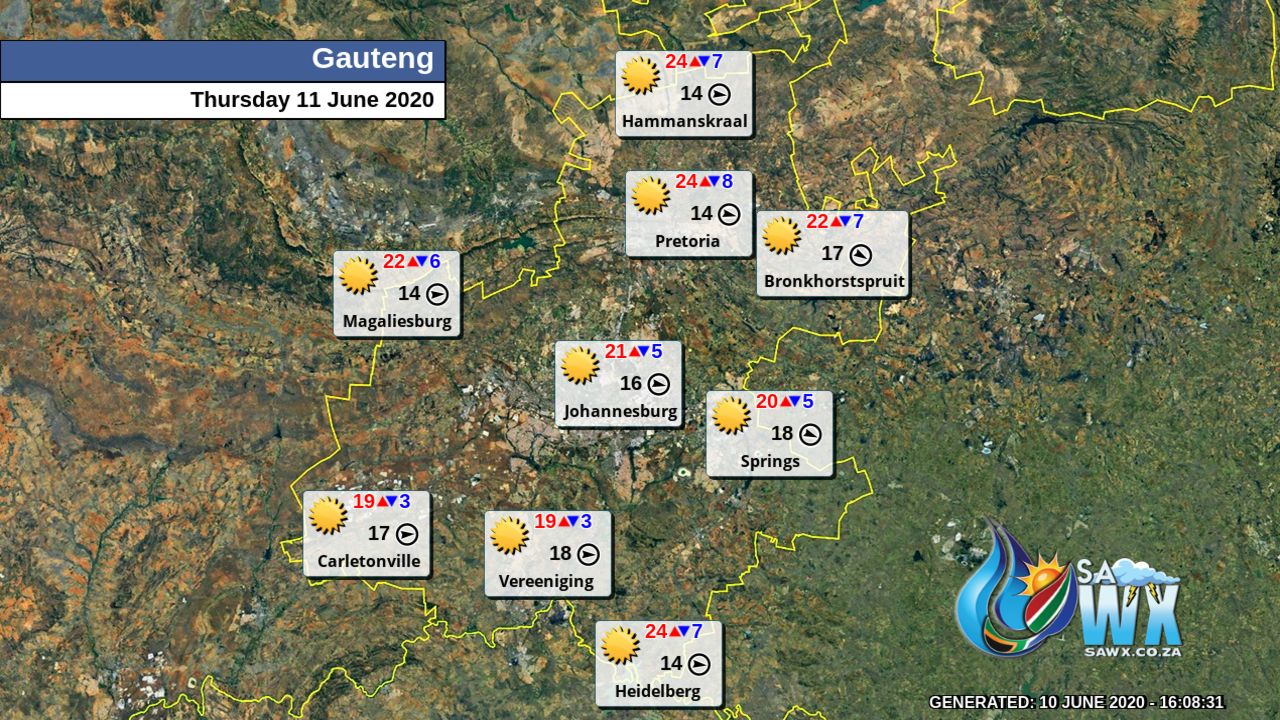
Gauteng Province Weather Map Thursday 11 June 2020
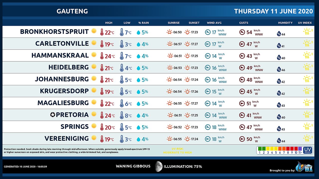
Gauteng Province Weather Meteogram Thursday 11 June 2020
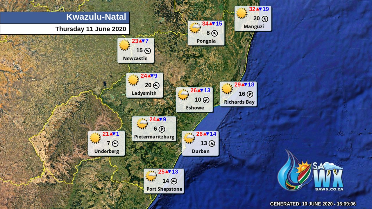
Kwazulu-Natal Province Weather Map Thursday 11 June 2020
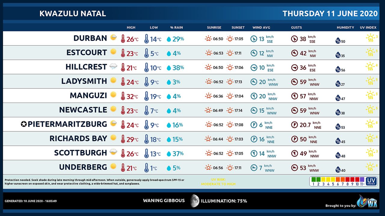
Kwazulu-Natal Province Weather Meteogram Thursday 11 June 2020
Eastern Cape Province Weather Map Thursday 11 June 2020
Eastern Cape Province Weather Meteogram Thursday 11 June 2020
Western Cape Province Weather Map Thursday 11 June 2020
Western Cape Province Weather Meteogram Thursday 11 June 2020
Northern Cape Province Weather Map Thursday 11 June 2020
Northern Cape Province Weather Meteogram Thursday 11 June 2020
North-West Province Weather Map Thursday 11 June 2020
North-West Province Weather Meteogram Thursday 11 June 2020
Limpopo Province Weather Map Thursday 11 June 2020
Limpopo Province Weather Meteogram Thursday 11 June 2020
Mpumalanga Province Weather Map Thursday 11 June 2020
Mpumalanga Province Weather Meteogram Thursday 11 June 2020
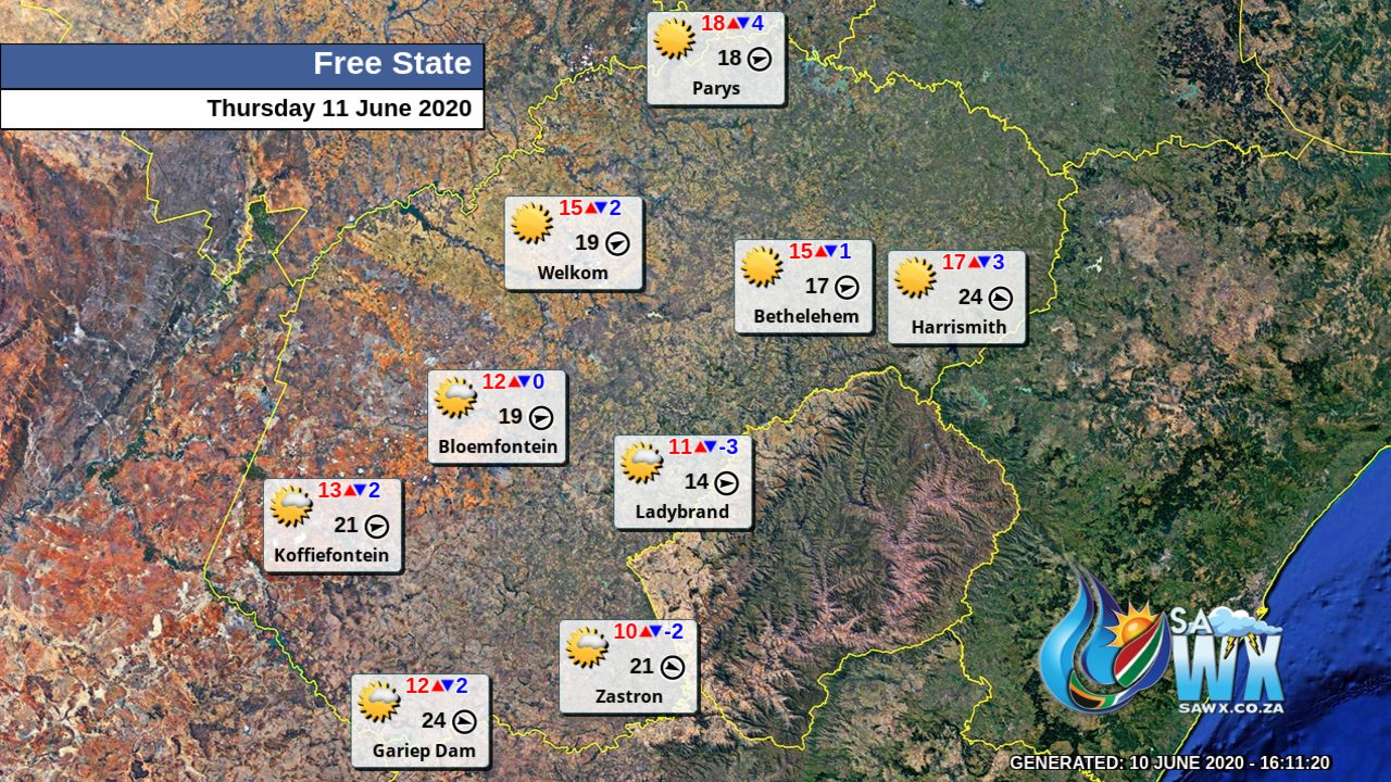
Free State Province Weather Map Thursday 11 June 2020
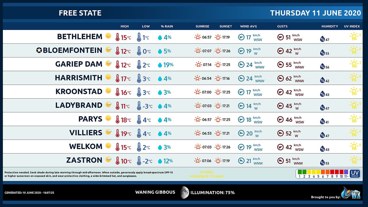
Free State Province Weather Meteogram Thursday 11 June 2020
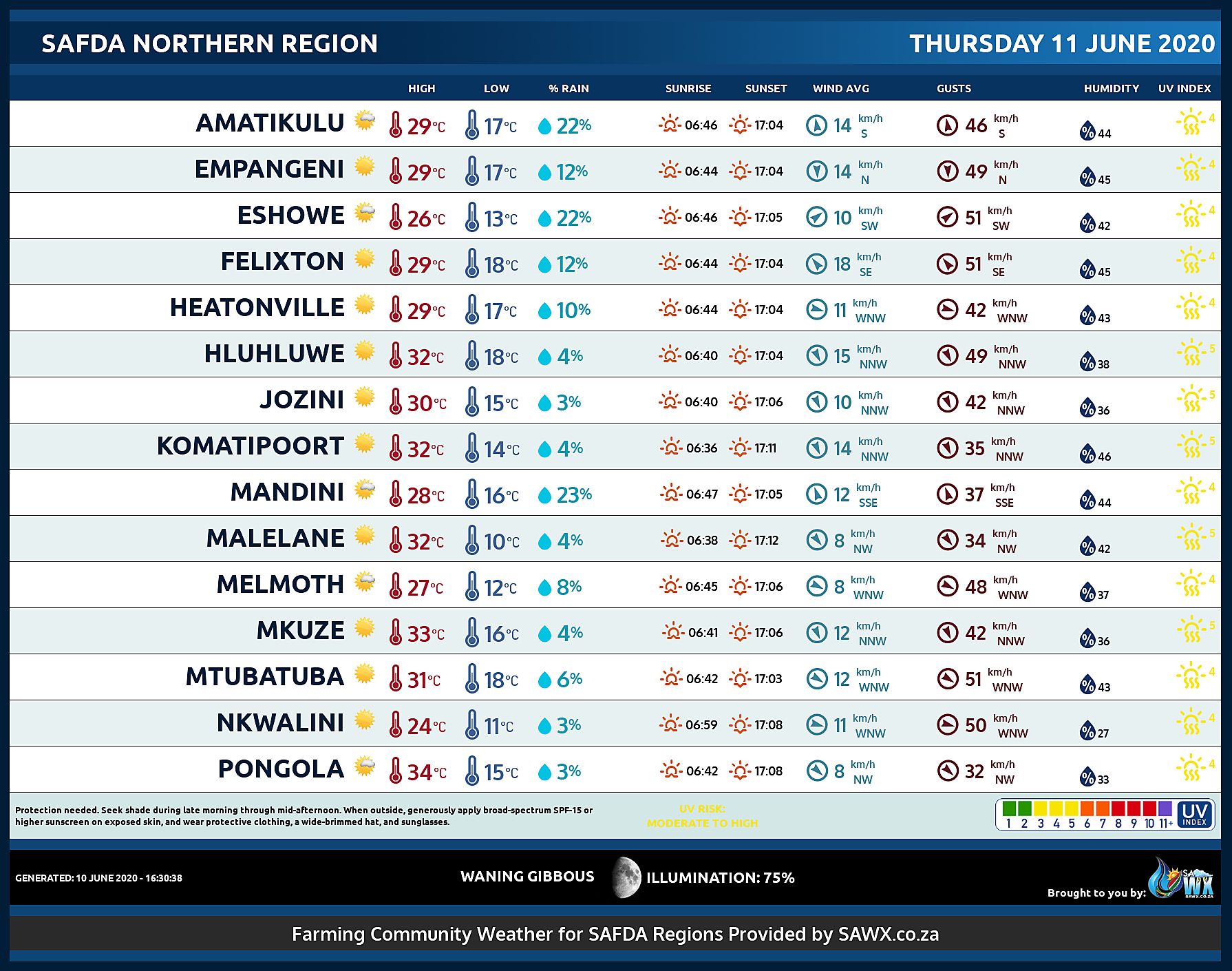
SAFDA Sugar Cane Farming (Northern Kwazulu-Natal) Weather Forecast Thursday 11 June 2020
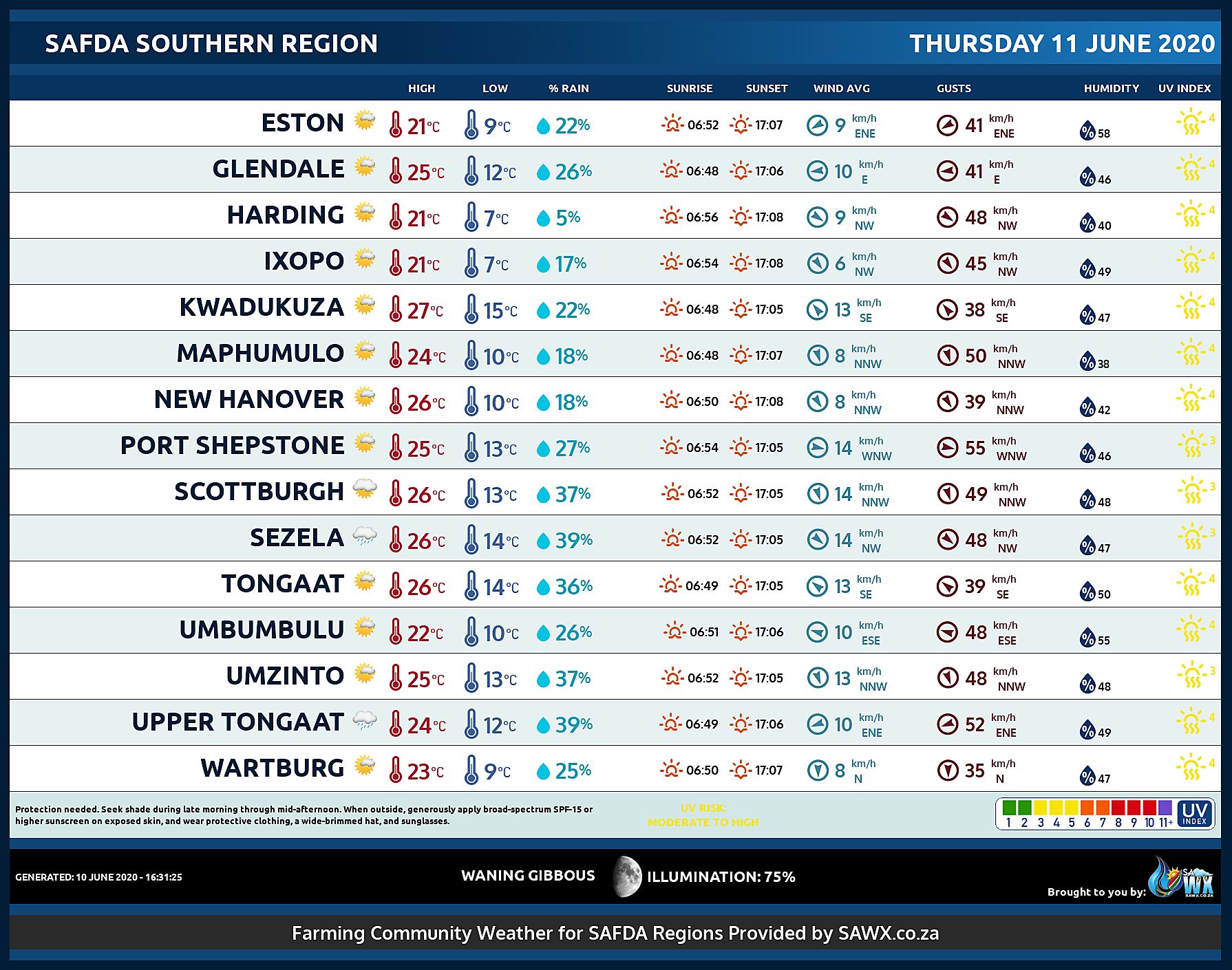
SAFDA Sugar Cane Farming (Southern Kwazulu-Natal) Weather Forecast Thursday 11 June 2020
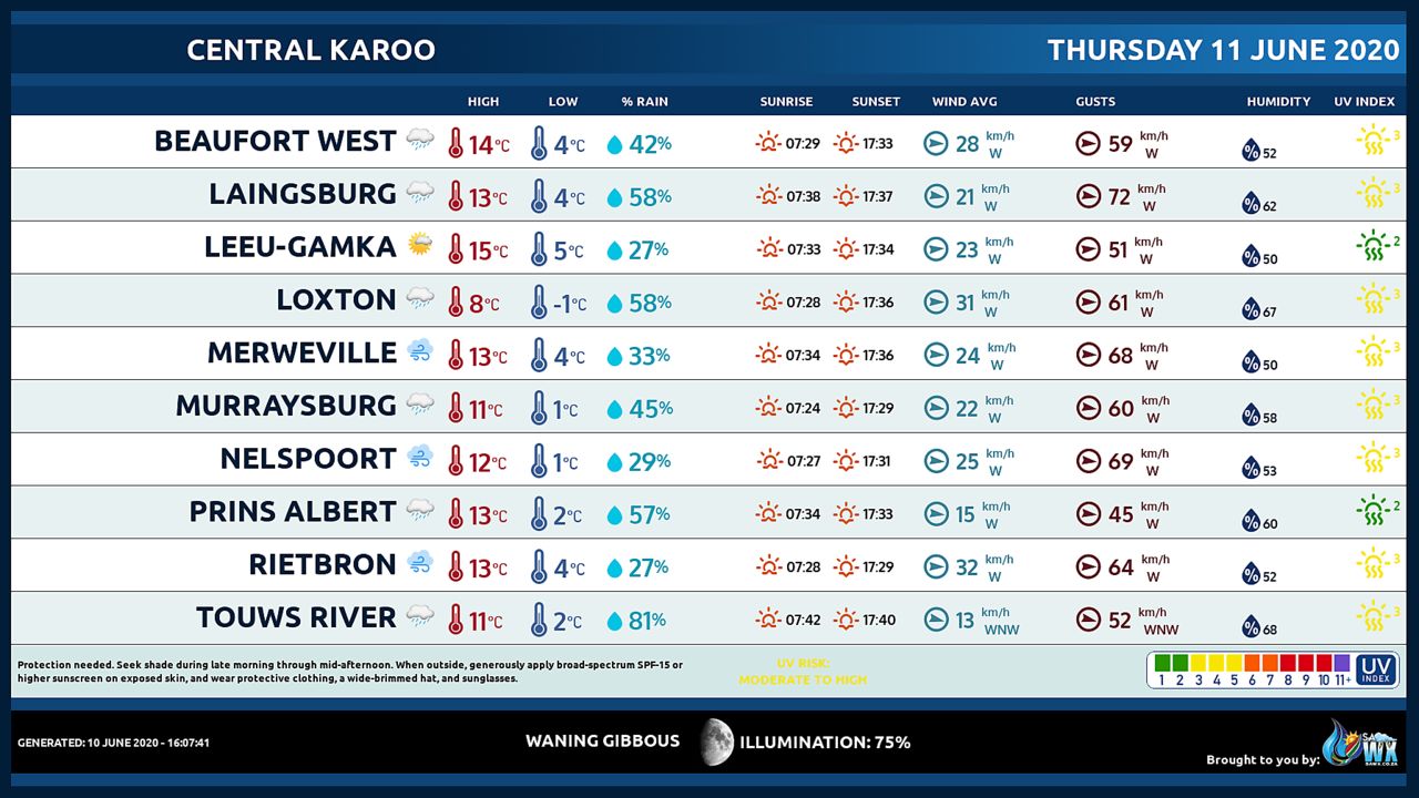
Central Karoo (Northern Cape) Farming Weather Forecast Thursday 11 June 2020
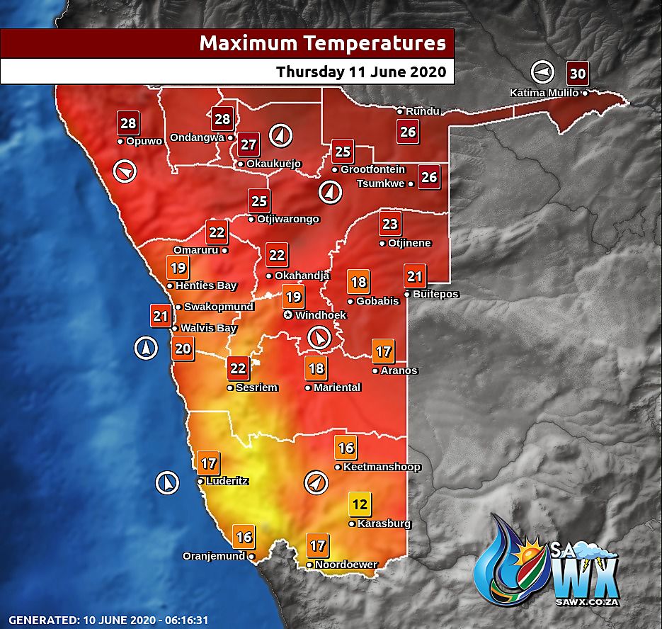
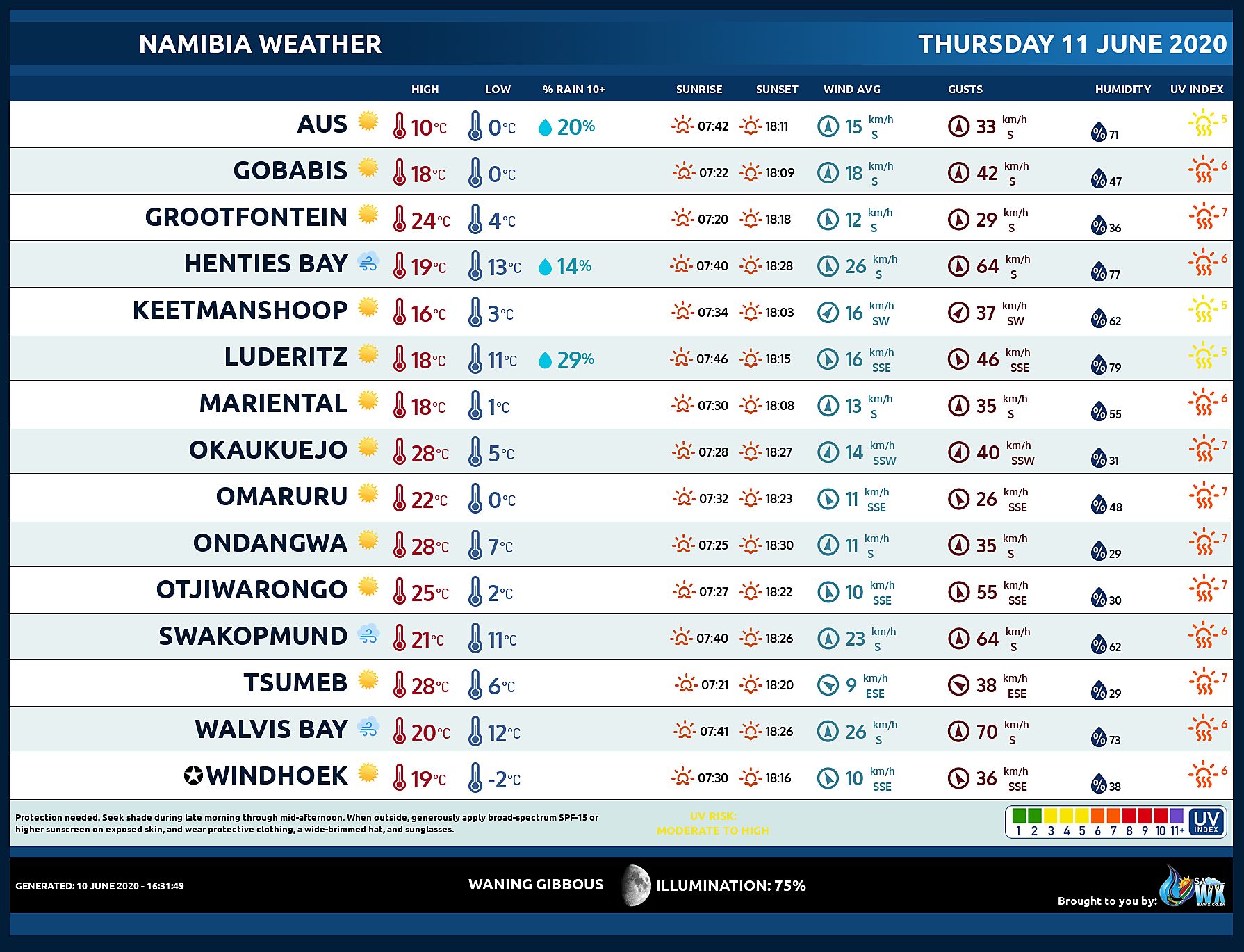
Namibia Maximum Temperatures Thursday 11 June 2020
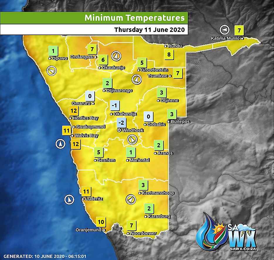
Namibia Minimum Temperatures Thursday 11 June 2020
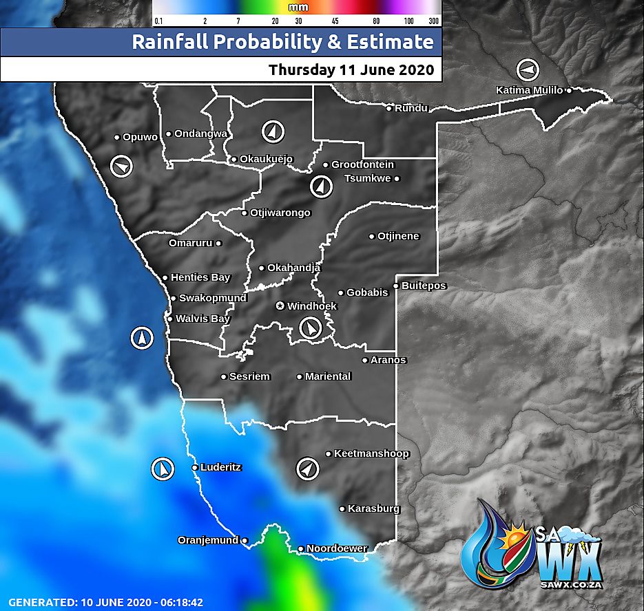
Namibia Rainfall Probability Map Thursday 11 June 2020
Namibia Weather Meteogram Thursday 11 June 2020
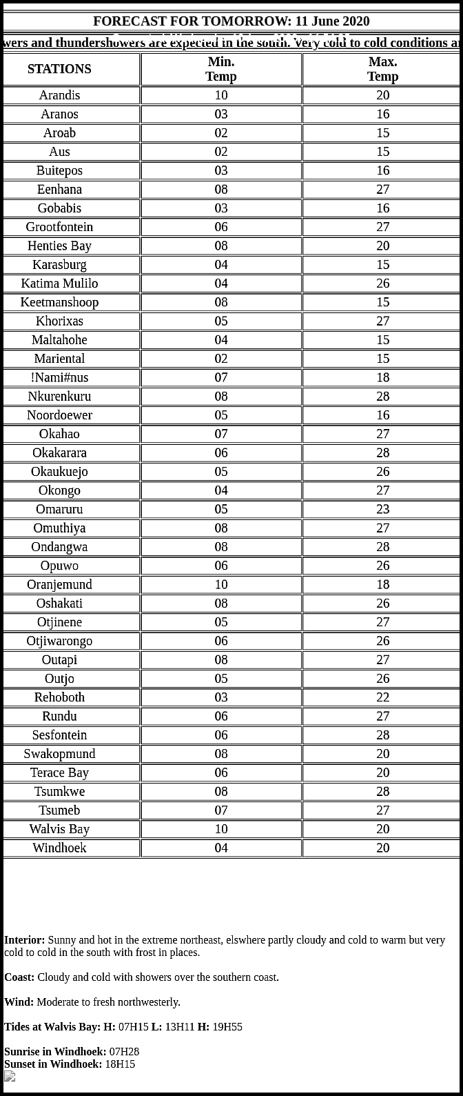
Namibia Meteorological Services METEONA Weather Forecast Thursday 11 June 2020
Weather Maps by SAWX – Feel Free to Share


