Last Updated on 26th August 2021 6:48 PM by AfriWX
THE REGIONAL WEATHER FORECAST
FOR TOMORROW 2021-08-27
ISSUED AT 1600 SAST
BY THE SOUTH AFRICAN WEATHER SERVICE. THIS FORECAST WILL BE UPDATED AT 0500 SAST.
SEVERE WEATHER ALERTS
IMPACT-BASED
WARNINGS
A. Yellow level 4 warning for disruptive rain leading to flooding is expected over the south-western parts of the Western Cape. B. Orange level 6 warning for disruptive rain leading to flooding is expected over the City of Cape Town, Drakenstein, Stellenbosch, Theewaterskloof and Overstrand LM’s of the Western Cape. C. Yellow level 2 warning for snow leading to loss of vulnerable livestock and crops is expected in the high-lying areas of the Cape Winelands, Garden Route, Central Karoo of the Western Cape as well as southern and western parts of Namakwa District of the Northern Cape. D. Yellow level 2 warning for waves resulting in difficult navigation at sea is expected between Alexander Bay and Plettenberg Bay. E. Yellow level 2 warning for wind resulting in localized damages to informal settlements, difficult driving conditions and problems for high-sides vehicles on prone routes is expected over the central parts of the North West and the central and eastern parts of the Free State. FIRE DANGER
WARNINGS
Extremely high fire danger conditions are expected in Gauteng, central and eastern parts of the North West, the eastern parts of the Free State and in places in Limpopo. ADVISORIES
1. Very cold, wet and windy conditions are expected over the southern, central and western parts of the Northern Cape, in places over the interior of the Western Cape spreading to the Eastern Cape, the southern Free State and the south-western high-ground of KwaZulu-Natal on Saturday.
2. Yellow level 4 warning for snow leading to loss of vulnerable livestock and crops, the closure of mountain passes, and disruption to traffic is expected over the high-lying areas of the Eastern Cape and the south-western and western high-ground of KwaZulu-Natal on Saturday.
3. Yellow level 2 warning for disruptive rain leading to localized flooding can be expected over the extreme eastern parts of the Eastern Cape on Saturday.
PROVINCIAL WEATHER OVERVIEW
GAUTENG PROVINCE
Fine, windy and warm, becoming partly cloudy from the afternoon. The expected UVB sunburn Index Extreme
MPUMALANGA PROVINCE
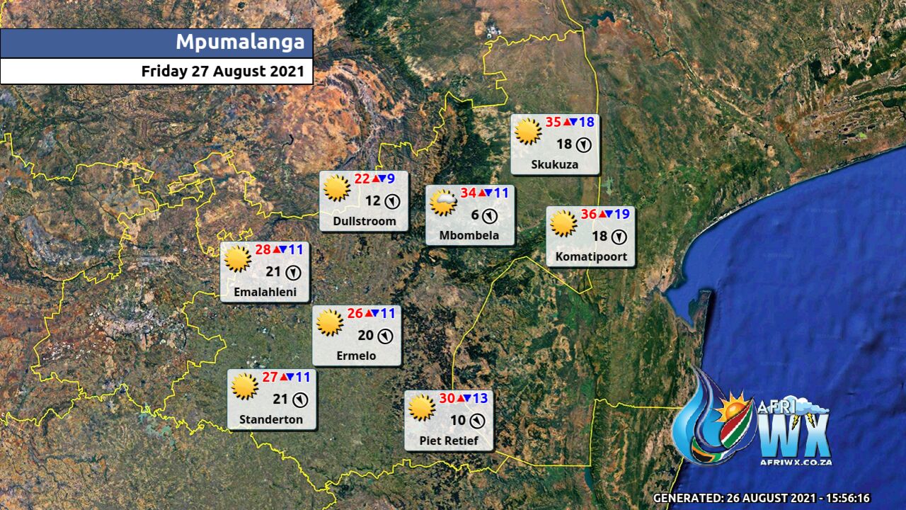
Fine and warm, but hot in the Lowveld. It will become partly cloudy in the west from the afternoon where it will be windy.
LIMPOPO PROVINCE
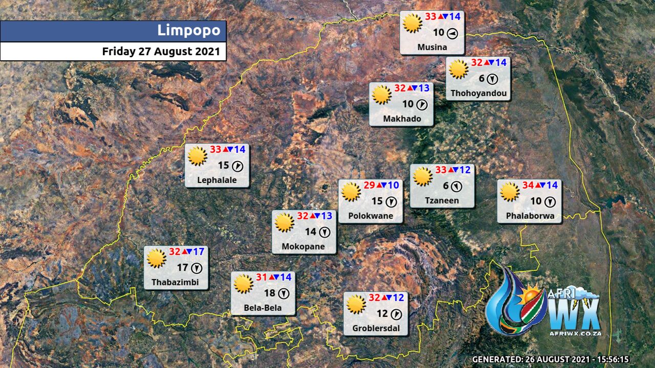
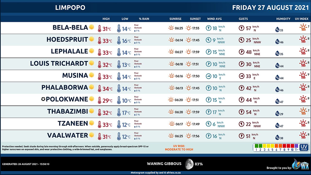
Fine and warm to hot.
NORTH-WEST PROVINCE
Partly cloudy, windy and warm.
FREE STATE
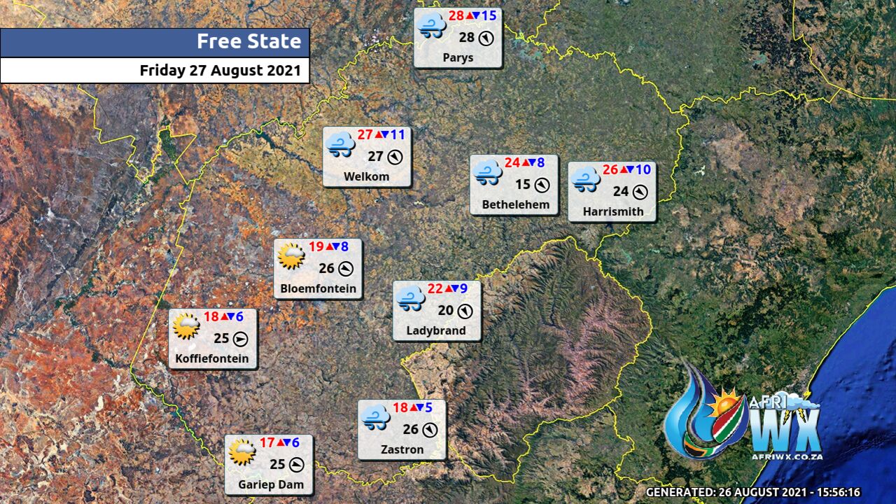
Warm in the extreme north-east, otherwise partly cloudy, windy and cool.
NORTHERN CAPE
Cool in the extreme north-east, otherwise partly cloudy, windy and cold, but cloudy over the central and western parts with isolated showers and rain but scattered in the west. Snow is expected over the southern and western high-ground where it will be very cold. The wind along the coast will be fresh to strong south-westerly becoming moderate westerly to north-westerly by evening.
WESTERN CAPE
Mostly cloudy and cold to very cold with scattered showers and rain but widespread in the west. Snow is expected on the high-ground. The wind along the coast will be strong westerly to south-westerly. The expected UVB sunburn Index Low
WESTERN HALF OF THE EASTERN CAPE
Cloudy and cold with isolated showers but scattered along the coast and adjacent interior. The wind along the coast will be fresh to strong south-westerly.
EASTERN HALF OF THE EASTERN CAPE
Partly cloudy and cool but warm in the east, becoming cloudy with scattered showers and rain from the afternoon. The wind along the coast will be moderate to fresh south-westerly.
KWAZULU-NATAL
Fine in the morning, otherwise partly cloudy and warm, but hot in places in the north-east. Isolated afternoon showers and thundershowers are expected in the south, but scattered in the extreme south-east. The wind along the coast will be moderate to fresh northerly to north-easterly, becoming southerly to south-westerly from the south from mid-morning, spreading to the north by the evening. The expected UVB sunburn Index Very High
JOIN OUR FREE AFRIWX WEATHER GROUP on Telegram Messenger
Please download Telegram for Android or iPhone if you want to always be up to date with the latest weather maps.
CLICK HERE TO JOIN our Telegram Group Now
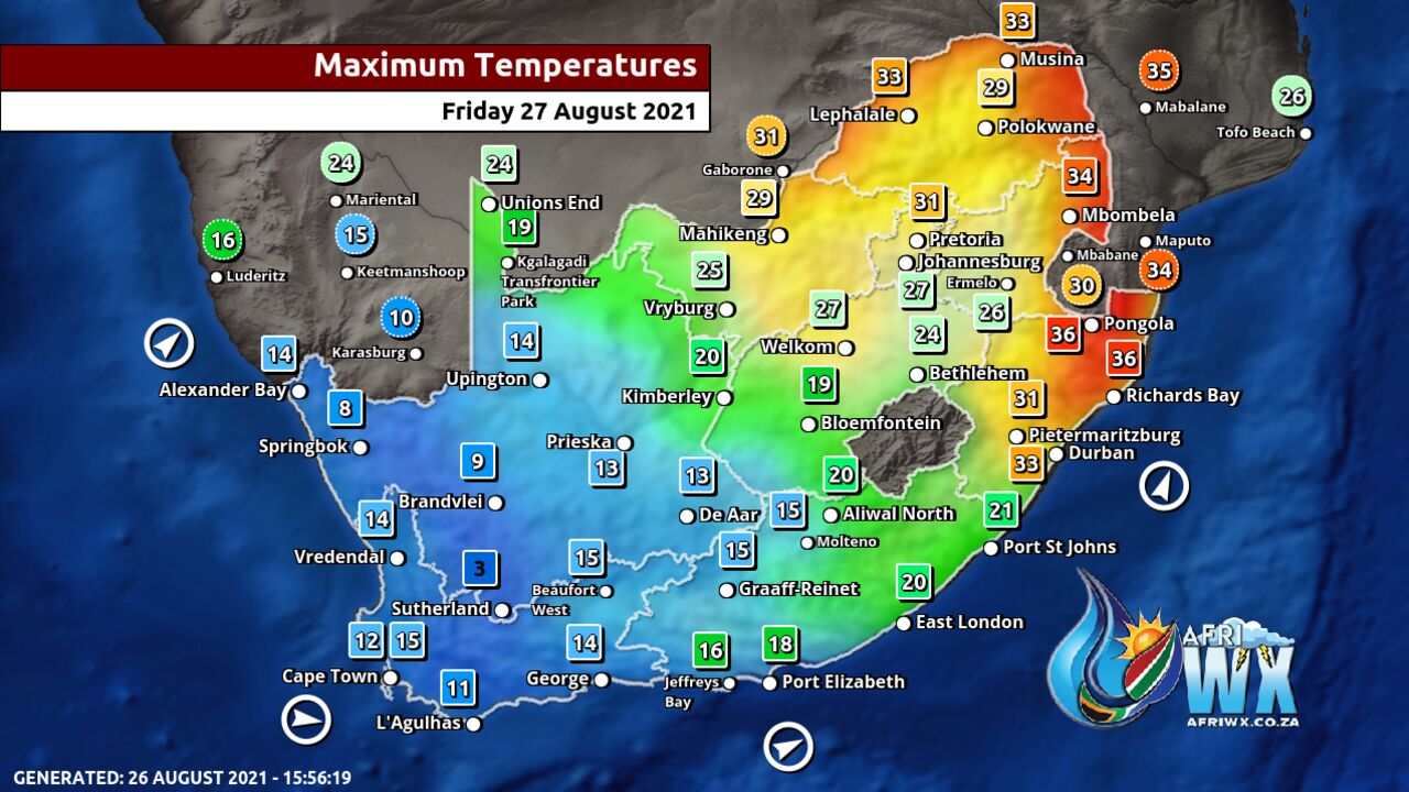
Maximum Temperatures Forecast for South Africa Friday 27 August 2021
Minimum Temperatures Forecast for South Africa Friday 27 August 2021
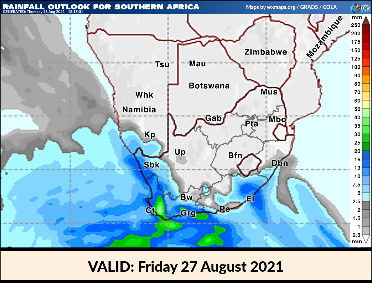
Rainfall Outlook for South Africa Friday 27 August 2021
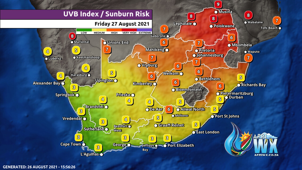
UVB Index Outlook for South Africa Friday 27 August 2021
Wind Speed Direction and Gusts Map for South Africa Friday 27 August 2021
TRAVELLERS WEATHER FORECAST
FOR TOMORROW 2021-08-27
ISSUED AT 1530 SAST
BY THE SOUTH AFRICAN WEATHER SERVICE.
SEVERE WEATHER ALERTS
IMPACT-BASED
WARNINGS
A.
Yellow level 4 warning for disruptive rain leading to flooding is expected over the south western parts of the Western Cape.
B.
Orange level 6 warning for disruptive rain leading to flooding is expected over the City of Cape Town, Drakenstein, Stellenbosch, Theewaterskloof and Overstrand LM’s of the Western Cape.
C.
Yellow level 2 warning for snow leading to loss of vulnerable livestock and crops is expected in the high-lying areas of the Cape Winelands, Garden Route, Central Karoo of the Western Cape as well as southern and western parts of Namakwa District of the Northern Cape.
D.
Yellow level 2 warning for waves resulting in difficult navigation at sea is expected between Alexander Bay and Plettenberg Bay.
E.
Yellow level 2 warning for wind resulting in localized damages to informal settlements, difficult driving conditions and problems for high-sides vehicles on prone routes is expected over the central parts of the North West and the central and eastern parts of the Free State.
FIRE DANGER
WARNINGS
Extremely high fire danger conditions are expected in Gauteng, central and eastern parts of the North West, the eastern parts of the Free State and in places in Limpopo.
ADVISORIES 1.
Very cold, wet and windy conditions are expected over the southern, central and western parts of the Northern Cape, in places over the interior of the Western Cape spreading to the Eastern Cape, the southern Free State and the south-western high-ground of KwaZulu-Natal on Saturday.
2.
Yellow level 4 warning for snow leading to loss of vulnerable livestock and crops, the closure of mountain passes, and disruption to traffic is expected over the high-lying areas of the Eastern Cape and the south-western and western high-ground of KwaZulu-Natal on Saturday.
3.
Yellow level 2 warning for disruptive rain leading to localized flooding can be expected over the extreme eastern parts of the Eastern Cape on Saturday.
WEATHER IN OUR TOP CITIES
PRETORIA
Fine and windy, becoming partly cloudy from the afternoon.
Minimum/Maximum 12/28 The expected UVB Sunburn Index Extreme
JOHANNESBURG
Fine and windy, becoming partly cloudy from the afternoon.
Minimum/Maximum 9/26
VEREENIGING
Partly cloudy and windy.
Minimum/Maximum 10/27
MBOMBELA
Fine.
Minimum/Maximum 13/30
POLOKWANE
Fine.
Minimum/Maximum 12/27
MAHIKENG
Partly cloudy and windy.
Minimum/Maximum 15/25
VRYBURG
Partly cloudy and windy.
Minimum/Maximum 14/21
BLOEMFONTEIN
Partly cloudy and windy.
Minimum/Maximum 10/19
KIMBERLEY
Partly cloudy and windy.
Minimum/Maximum 11/17
UPINGTON
Partly cloudy and windy with light showers and rain in the late afternoon.
Minimum/Maximum 5/14
CAPE TOWN
Mostly cloudy with widespread showers.
Wind Fresh westerly becoming moderate south-westerly in the afternoon.
Minimum/Maximum 9/13 The expected UVB Sunburn Index Low
GEORGE
Mostly cloudy with scattered showers.
Wind Strong north-westerly at first, otherwise fresh westerly.
Minimum/Maximum 7/12 GQEBERHA Cloudy with showers.
Wind Strong south-westerly.
Minimum/Maximum 9/15
EAST LONDON
Partly cloudy, becoming cloudy with scattered showers from late afternoon.
Wind Fresh to strong south-westerly.
Minimum/Maximum 11/18
DURBAN
Fine, becoming partly cloudy from late morning but cloudy in the evening with isolated showers and rain.
Wind Moderate to fresh north-easterly, becoming moderate to fresh southerly to south-westerly by late morning.
Minimum/Maximum 16/30 The expected UVB Sunburn Index Very High
RICHARDS BAY
Fine, becoming partly cloudy in the afternoon.
Wind Moderate to fresh northerly to north-easterly, becoming southerly to south-westerly in the afternoon.
Minimum/Maximum 18/35
PIETERMARITZBURG
Fine, becoming partly cloudy in the afternoon with isolated showers and thundershowers.
Minimum/Maximum 15/34
JOIN OUR FREE AFRIWX WEATHER GROUP on Telegram Messenger
Please download Telegram for Android or iPhone if you want to always be up to date with the latest weather maps.
CLICK HERE TO JOIN our Telegram Group Now
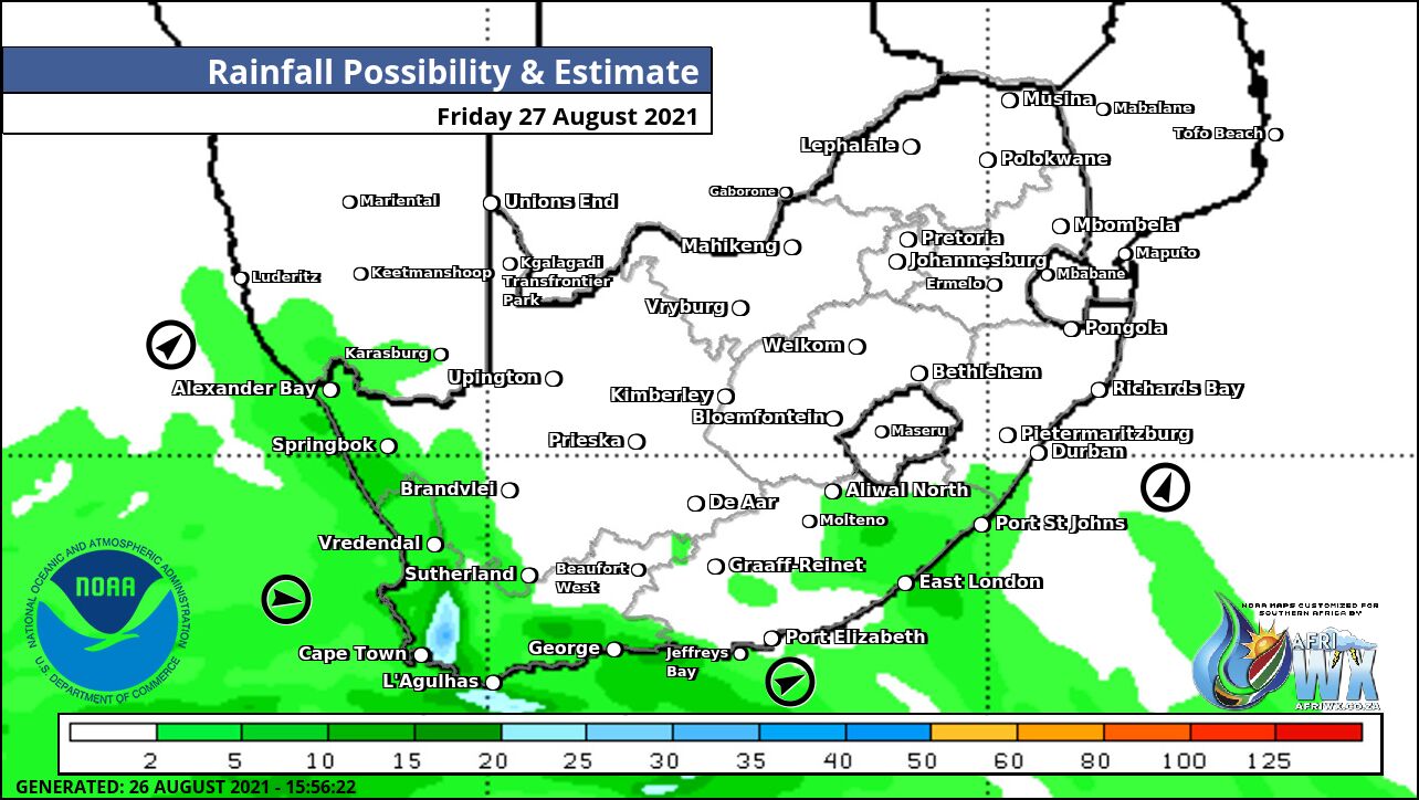
Rainfall Outlook for Tomorrow Friday 27 August 2021
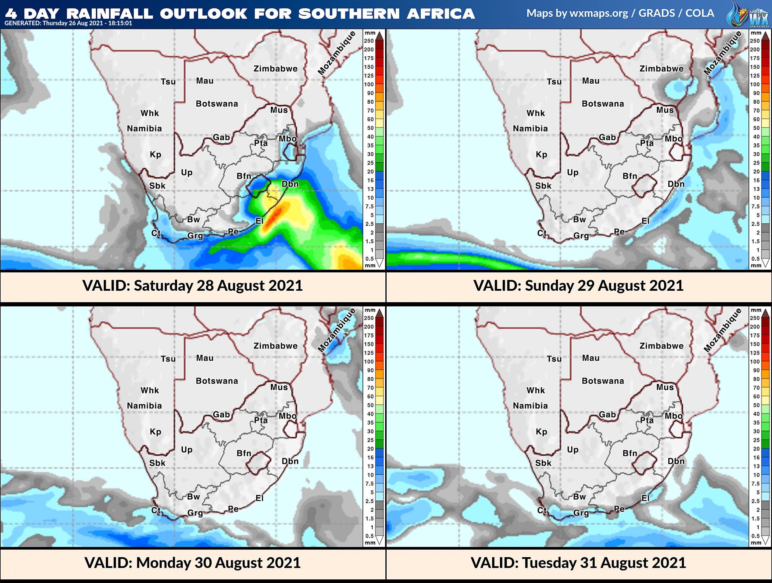
4 Day Rainfall Outlook for Southern Africa
14 Day Rainfall Outlook for Southern Africa
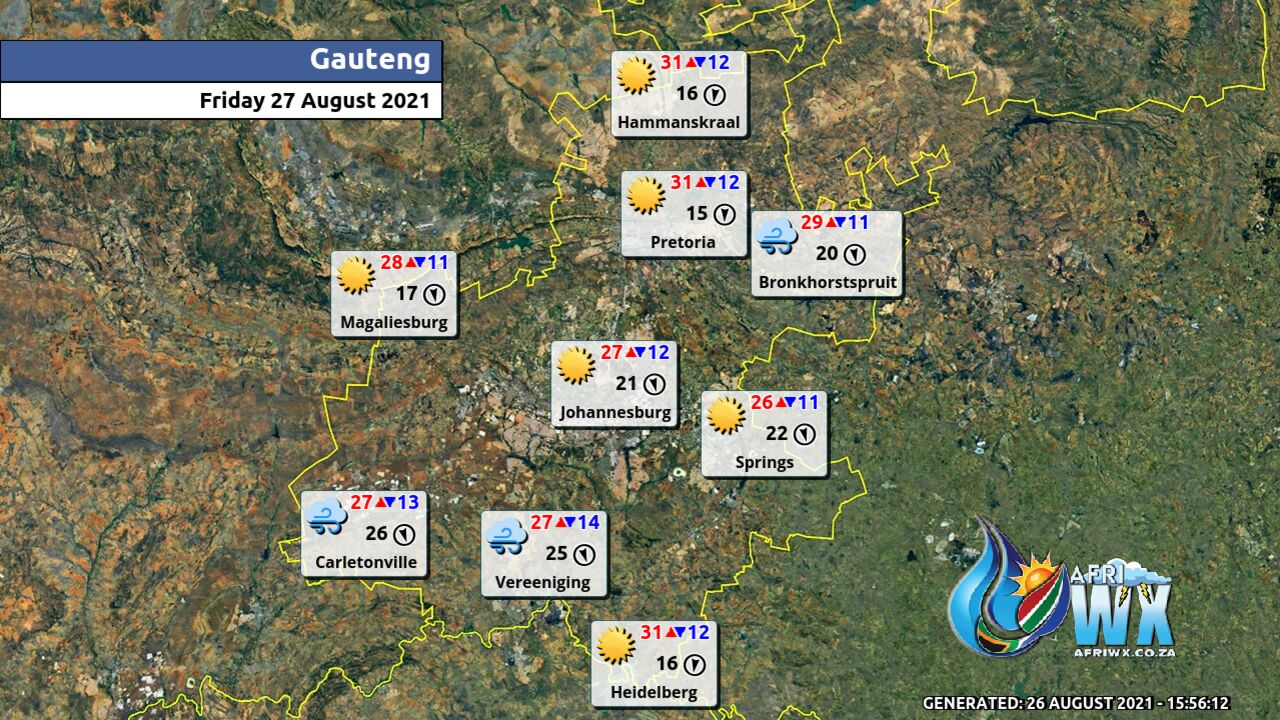
Gauteng Province Weather Map Friday 27 August 2021
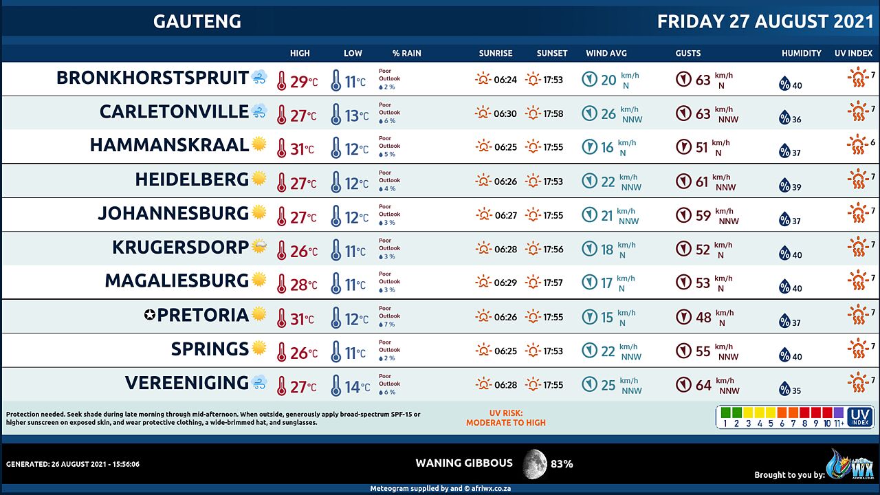
Gauteng Province Weather Meteogram Friday 27 August 2021
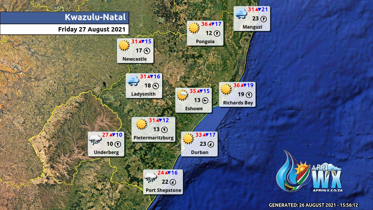
Kwazulu-Natal Province Weather Map Friday 27 August 2021
Kwazulu-Natal Province Weather Meteogram Friday 27 August 2021
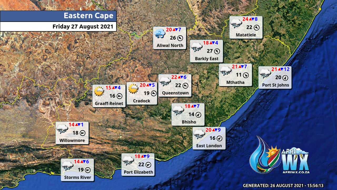
Eastern Cape Province Weather Map Friday 27 August 2021
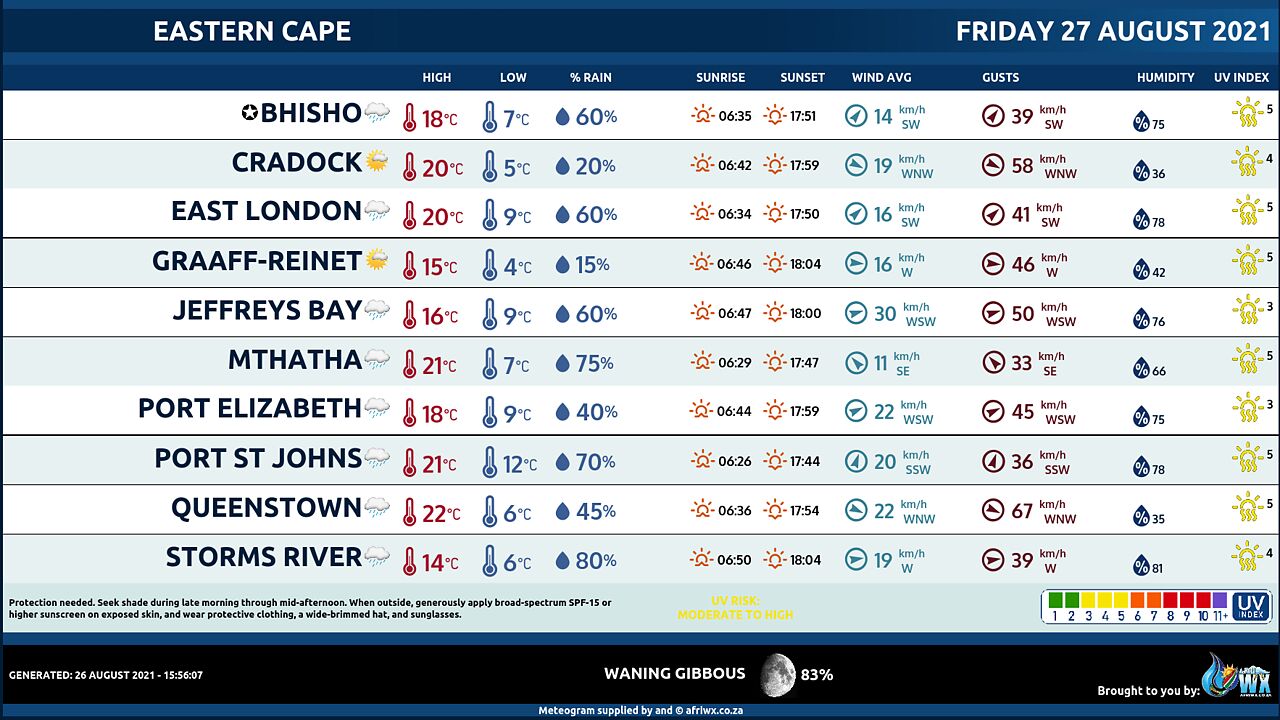
Eastern Cape Province Weather Meteogram Friday 27 August 2021
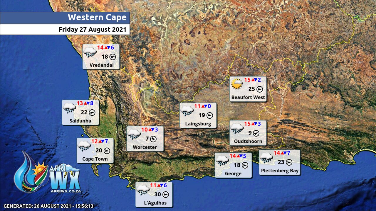
Western Cape Province Weather Map Friday 27 August 2021
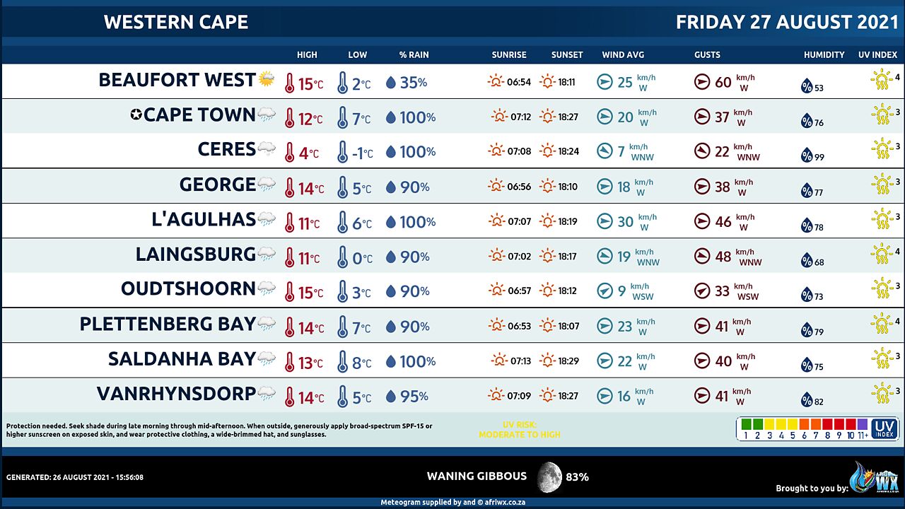
Western Cape Province Weather Meteogram Friday 27 August 2021
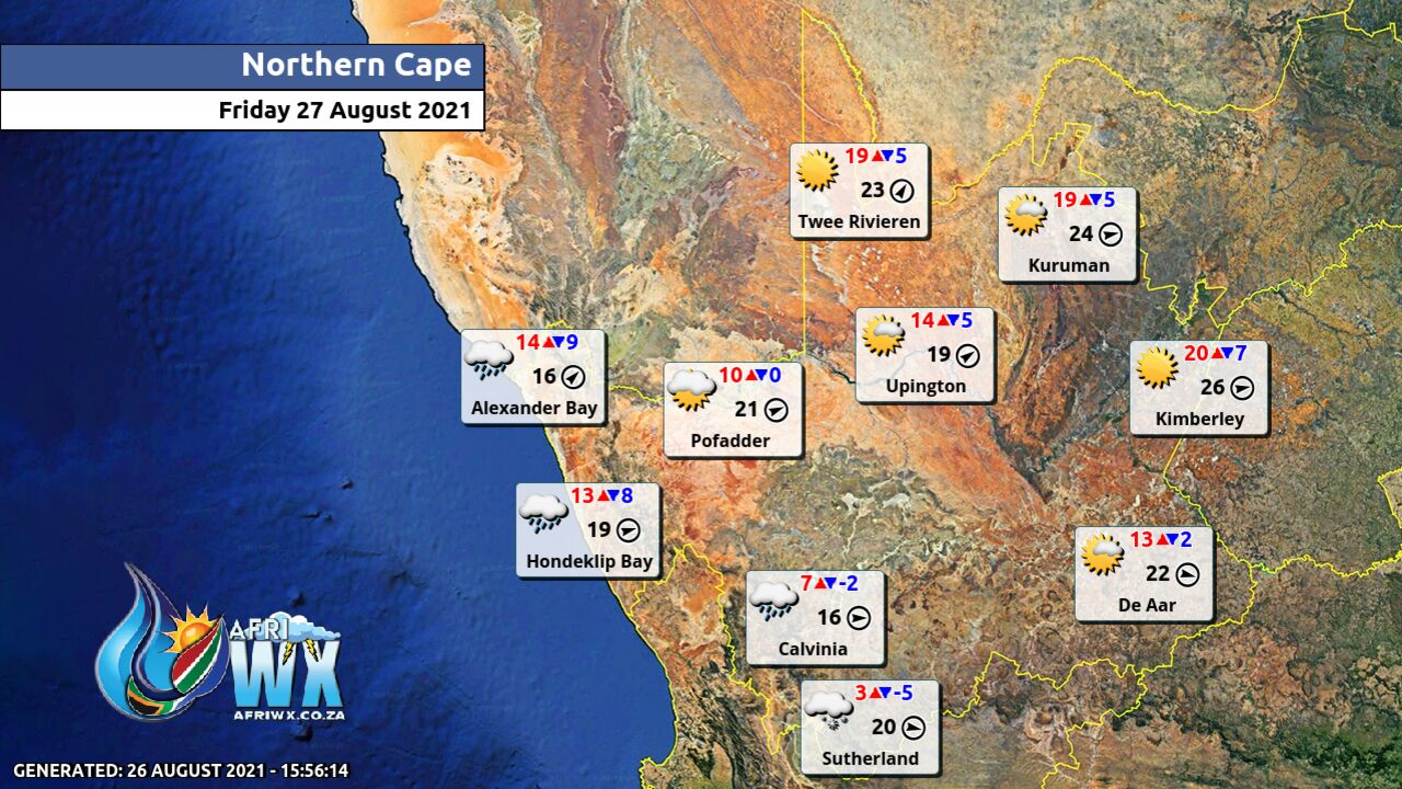
Northern Cape Province Weather Map Friday 27 August 2021
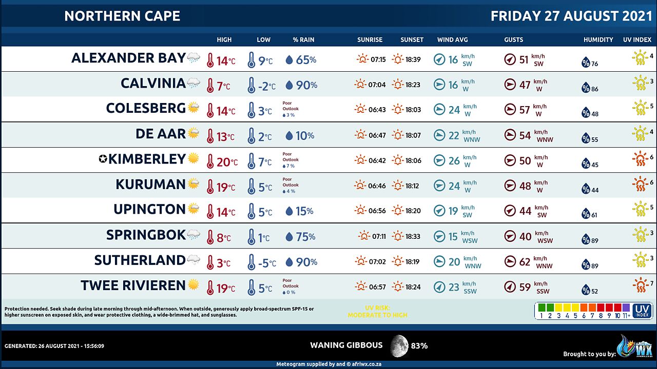
Northern Cape Province Weather Meteogram Friday 27 August 2021
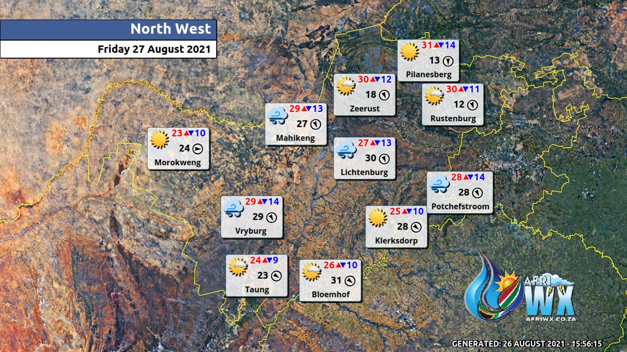
North-West Province Weather Map Friday 27 August 2021
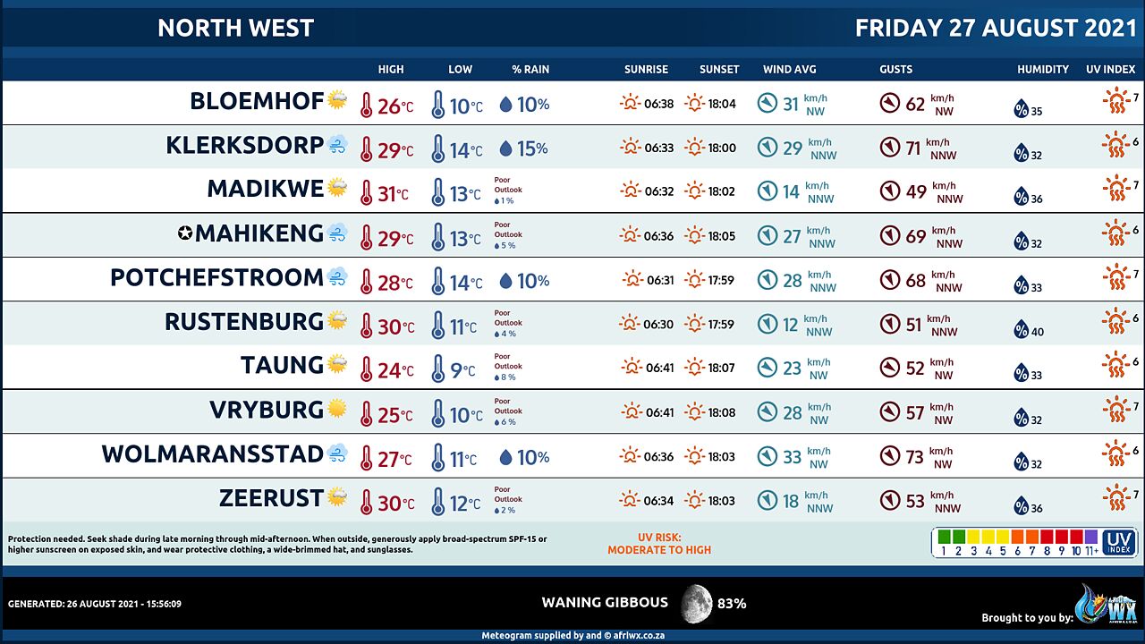
North-West Province Weather Meteogram Friday 27 August 2021
Limpopo Province Weather Map Friday 27 August 2021
Limpopo Province Weather Meteogram Friday 27 August 2021
Mpumalanga Province Weather Map Friday 27 August 2021
Mpumalanga Province Weather Meteogram Friday 27 August 2021
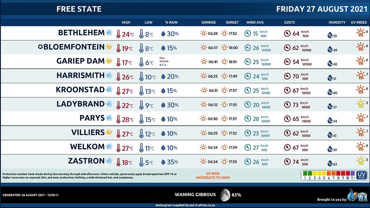
Free State Province Weather Map Friday 27 August 2021
Free State Province Weather Meteogram Friday 27 August 2021
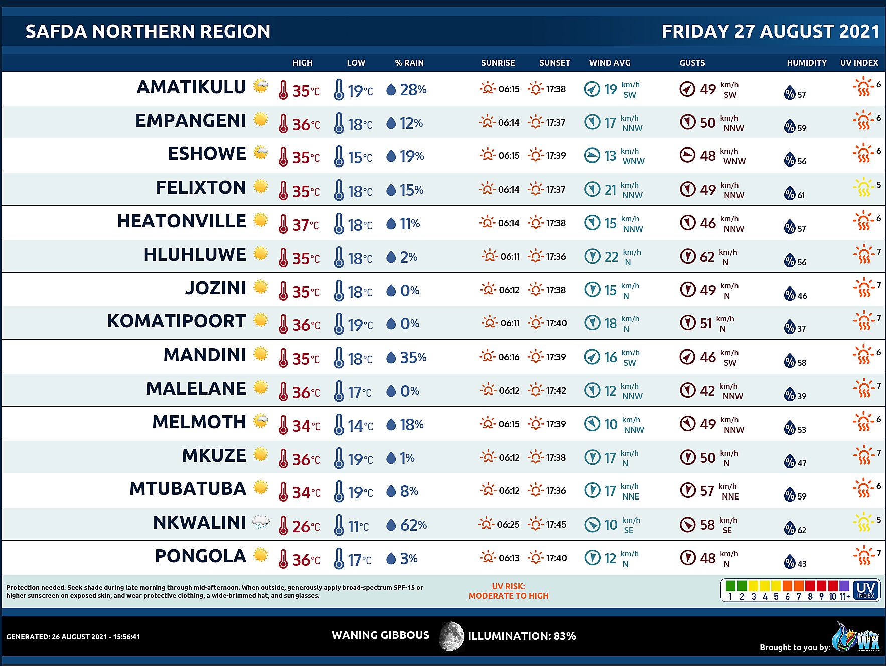
SAFDA Sugar Cane Farming (Northern Kwazulu-Natal) Weather Forecast Friday 27 August 2021
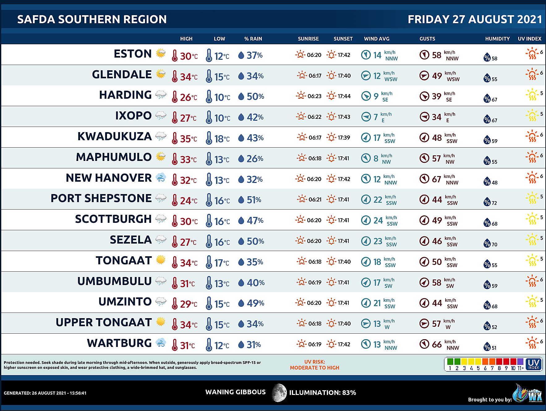
SAFDA Sugar Cane Farming (Southern Kwazulu-Natal) Weather Forecast Friday 27 August 2021
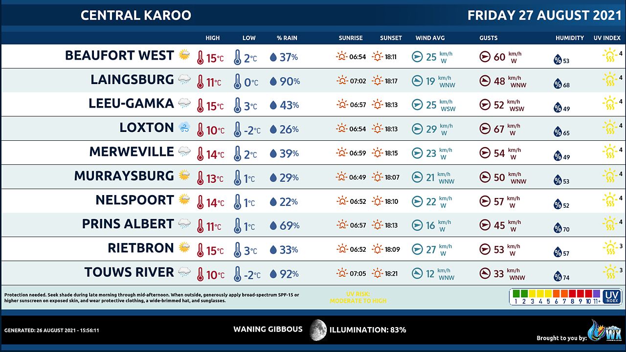
Central Karoo (Northern Cape) Farming Weather Forecast Friday 27 August 2021
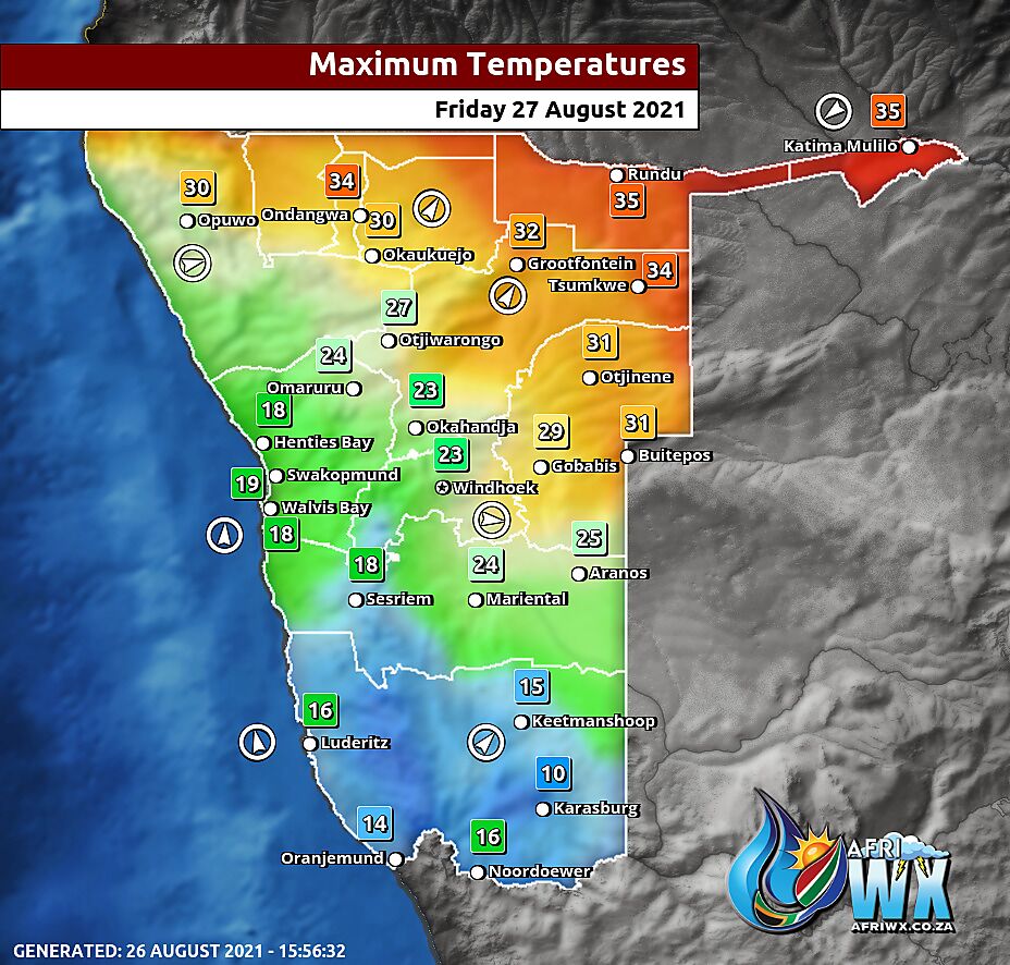
Namibia Maximum Temperatures Friday 27 August 2021
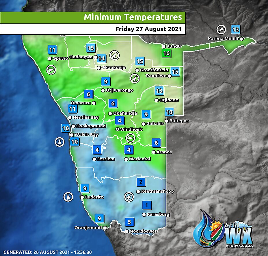
Namibia Minimum Temperatures Friday 27 August 2021
Namibia Rainfall Probability Map Friday 27 August 2021
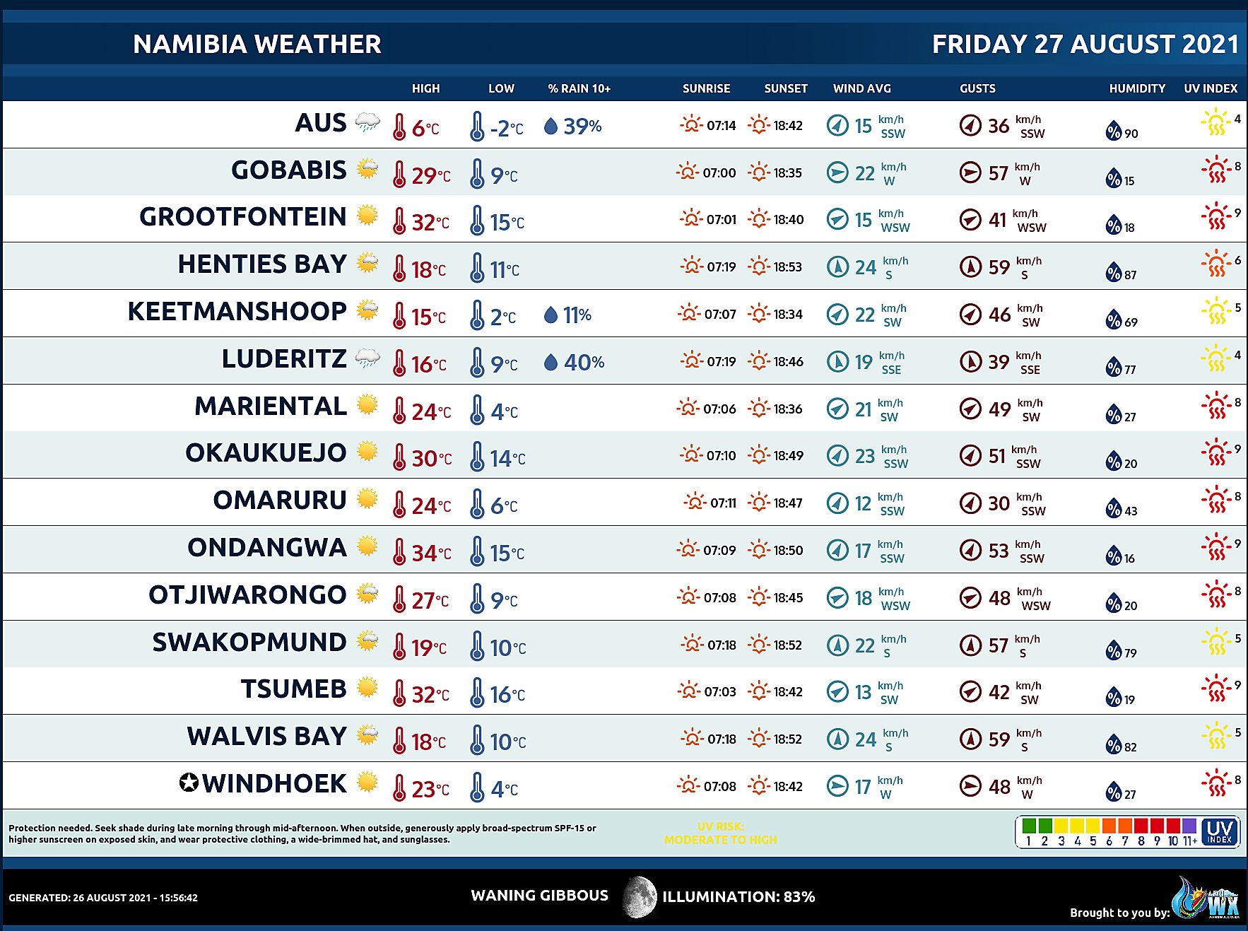
Namibia Weather Meteogram Friday 27 August 2021
Namibia Meteorological Services METEONA Weather Forecast Friday 27 August 2021
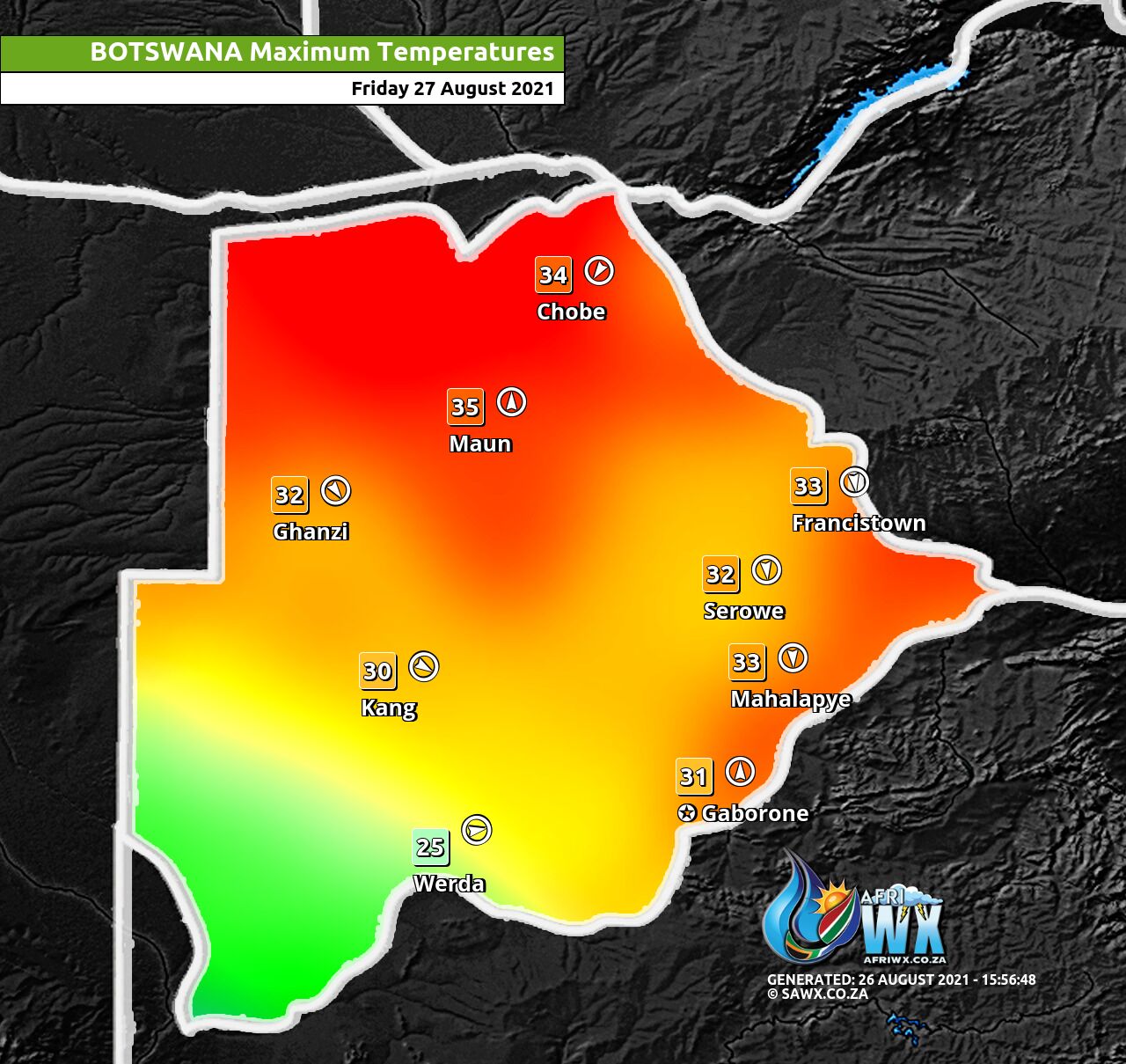
Botswana Maximum Temperatures Friday 27 August 2021
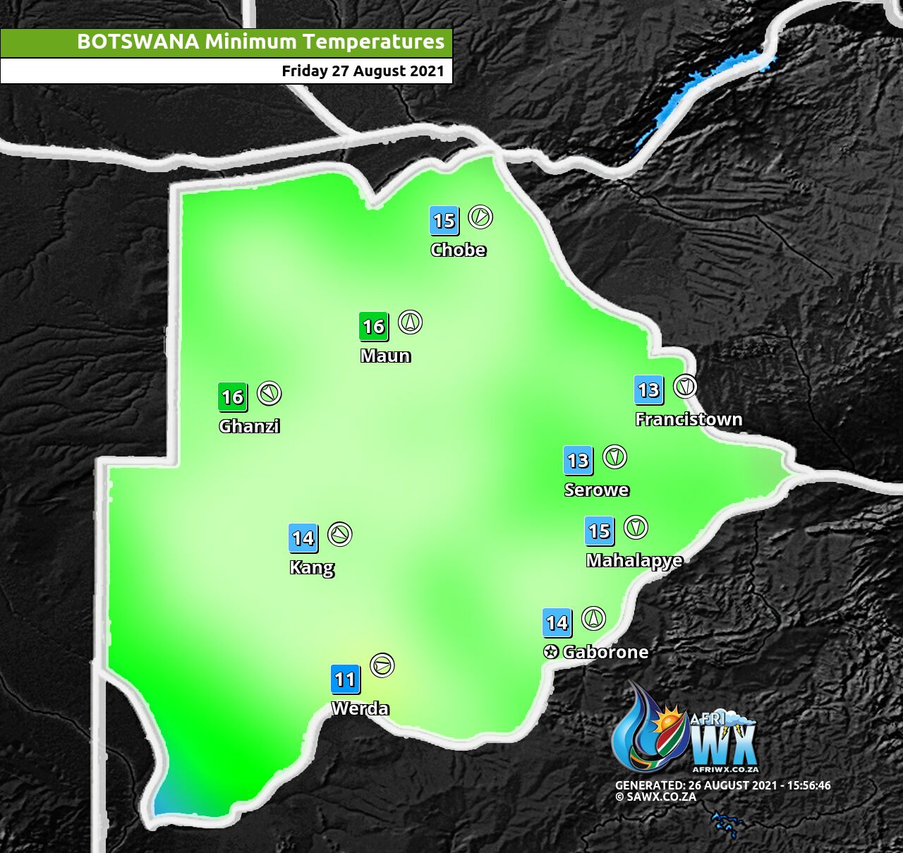
Botswana Minimum Temperatures Friday 27 August 2021
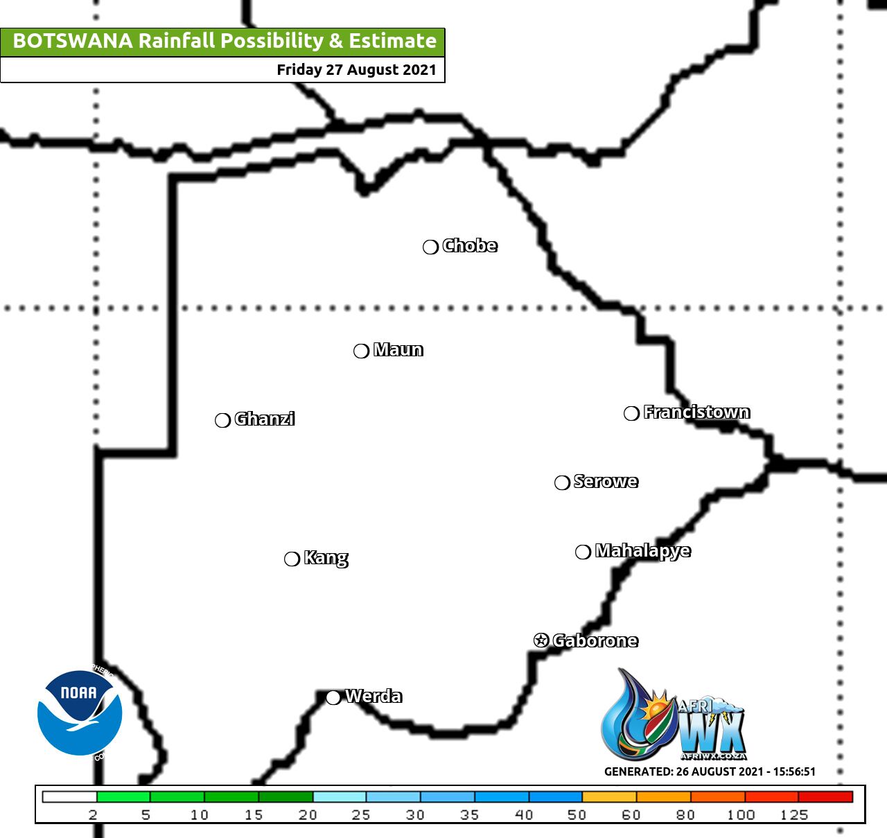
Botswana Rainfall Possibility Map Friday 27 August 2021
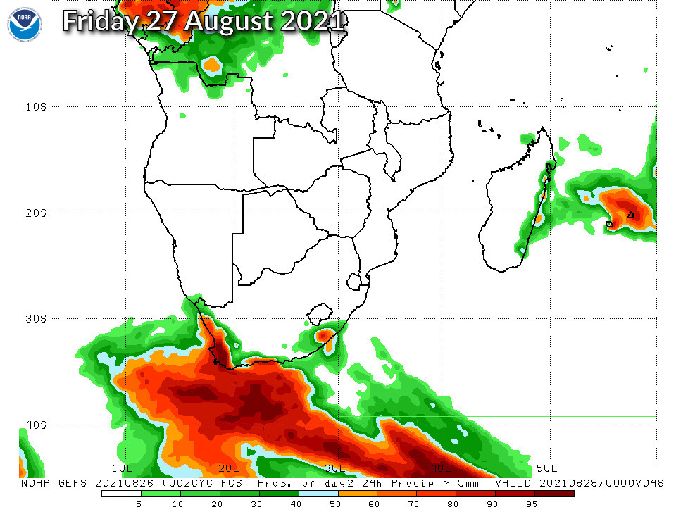
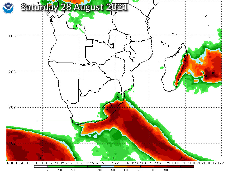
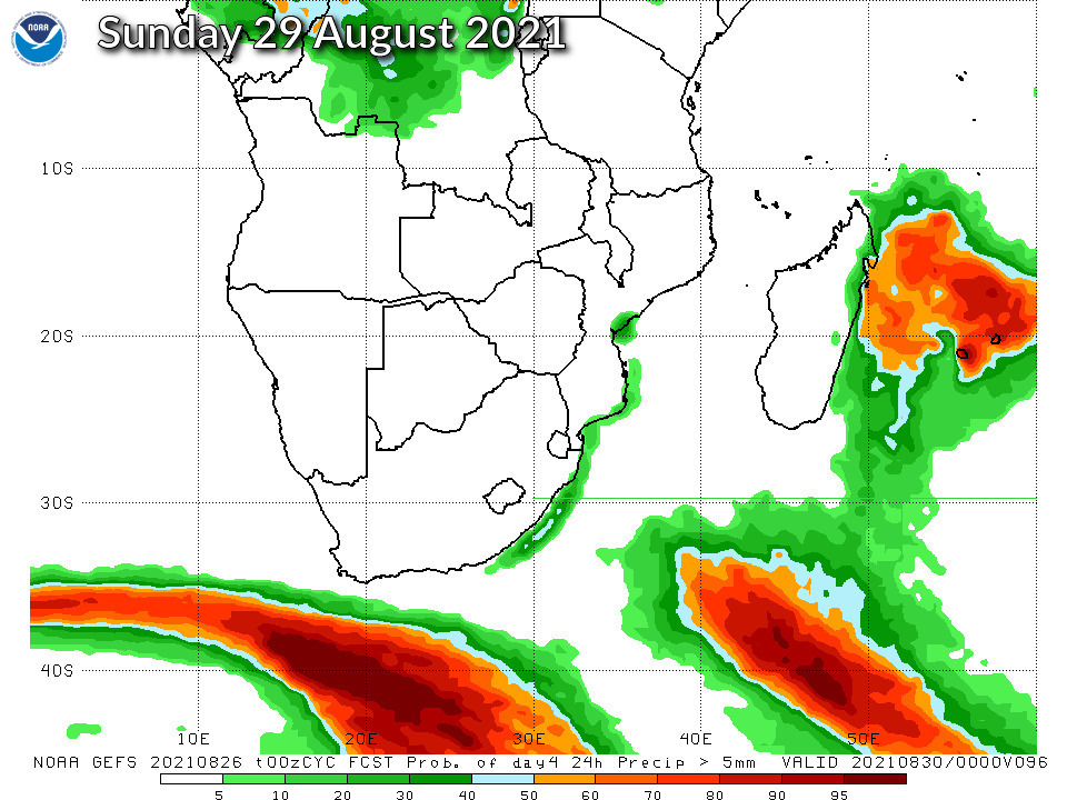
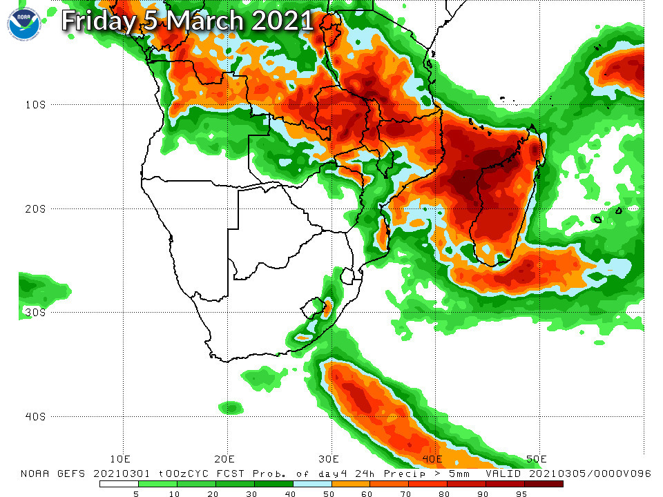
NOAA GEFS Global Ensemble Rainfall Outlook Southern Africa
JOIN OUR FREE AFRIWX WEATHER GROUP on Telegram Messenger
Please download Telegram for Android or iPhone if you want to always be up to date with the latest weather maps.
CLICK HERE TO JOIN our Telegram Group Now


