Last Updated on 11th February 2021 8:52 AM by AfriWX
La Niña is very active in Southern Africa and expected to last until the first even second quarter of 2021. Some of the information and maps here are from NOAA and the Bureau of Meteorology (BOM) Australia. Some of the information I present to you are based on my own personal experiences from the last Strong La Niña in 2010-2011.
My own personal experiences with La Niña
The last strong La Niña in 2011 I have very strong memories of. I was living on a farm in Magaliesburg, Gauteng at the time. We had good summer rainfalls with flooding in parts of the country as we have experienced this year but this year’s flooding seems to be a lot worse for some regions.
The part I remember the most was a very early autumn and a wet autumn with rainfall starting up again in late Feb early March raining right into the second week of May which was then followed by one of the coldest winters I have ever personally experienced.
I remember one morning in June stepping out the back door and going back inside with 2 seconds.
I had a weather station so went to the computer screen to check the temperature outside which was -11 deg C and -16 deg C with windchill. A report of a reading that morning of -26 Deg c was reported from the top of the Magaliesburg mountains.
Long Term Rainfall Outlook 2021
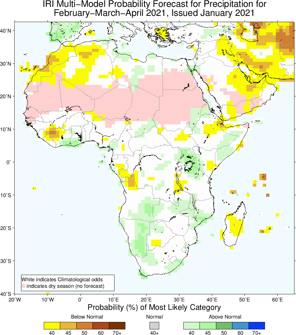
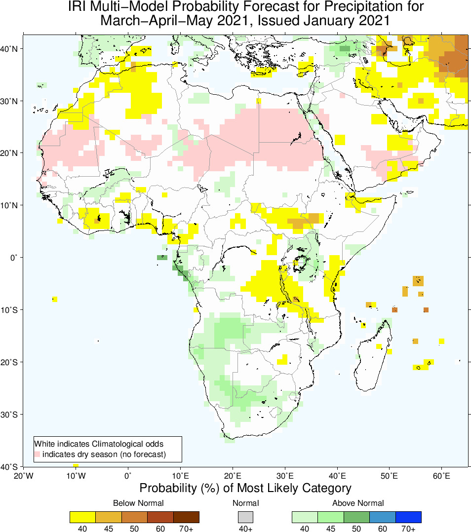
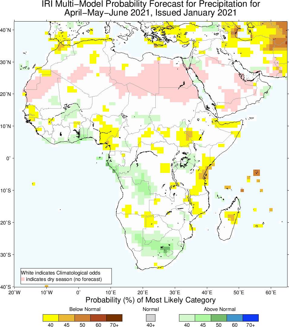
These long term rainfall maps from the Climate Society (IRI) seem to reaffirm my suspicions of what lies ahead still for us in 2021 with La Niña.
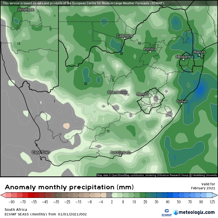
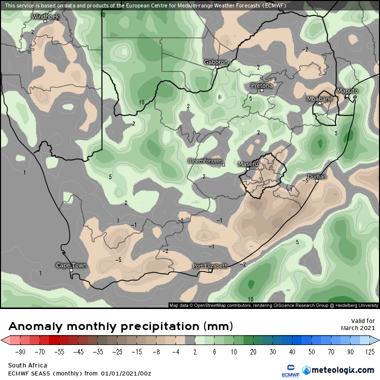
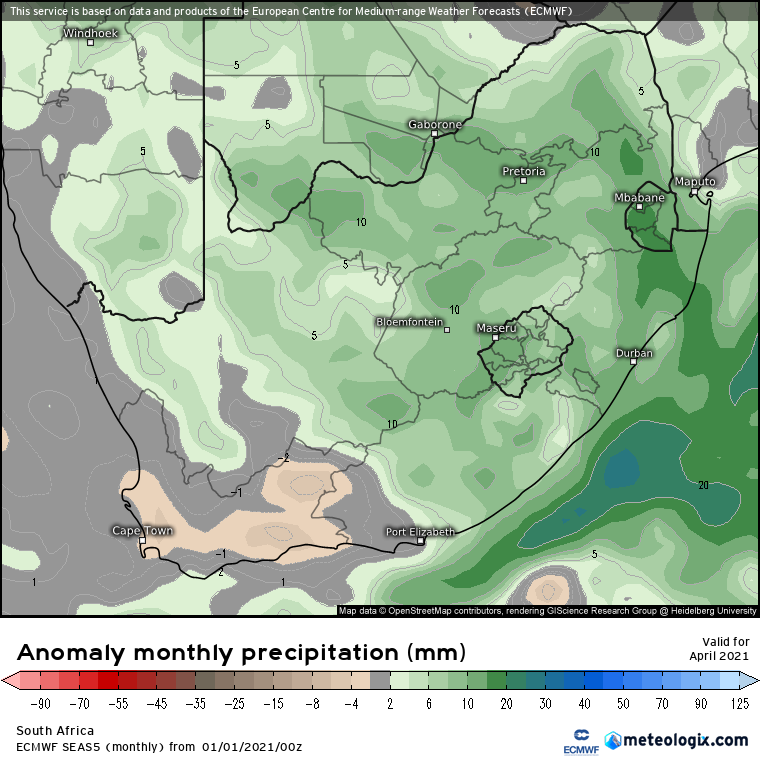
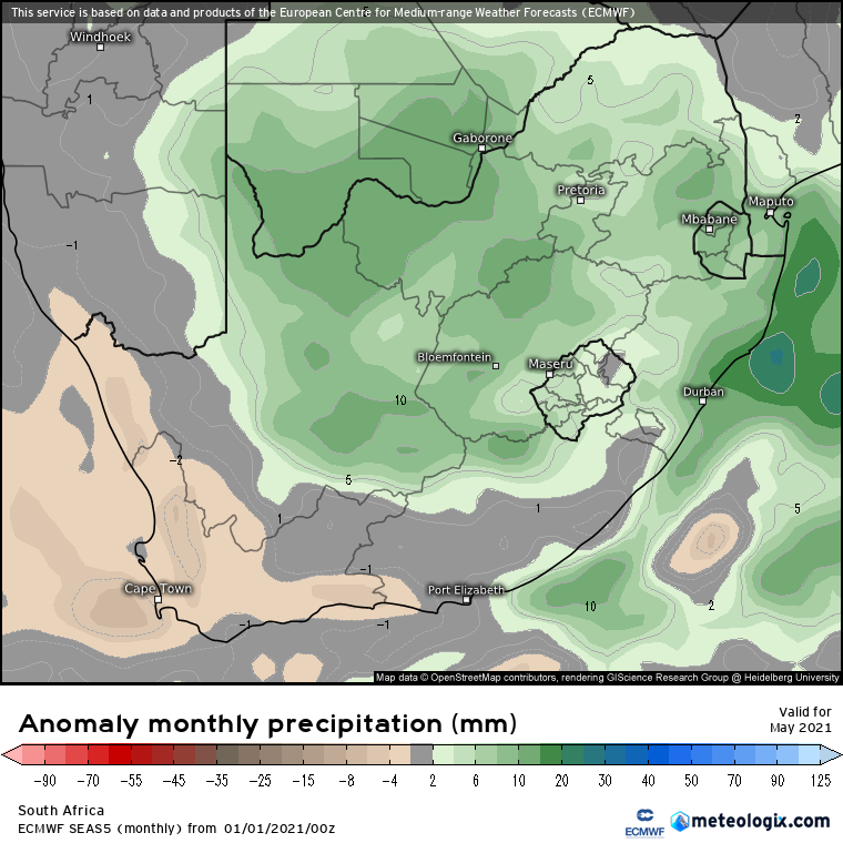
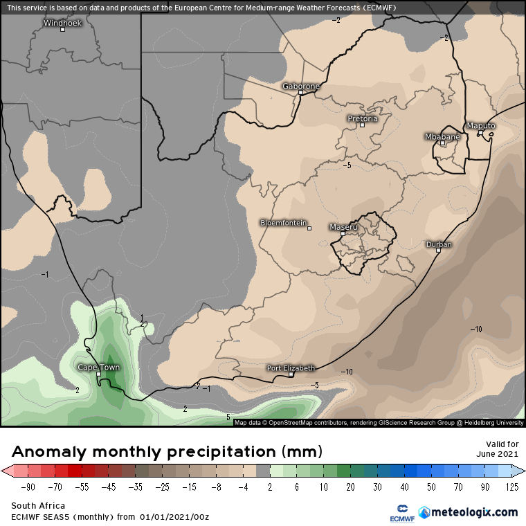
Additionally the long term rainfall anomaly maps from my Meteologix paid subscription also seem to reaffirm this trend.
Augrabies Falls in Flood
Gariep Dam in Full Flood
Beautiful animation of Tropical Cyclone Eloise and La Niña kicking into high gear
La Niña Global impacts
Courtesy NOAA – La Niña’s altered atmospheric circulation over the Pacific Ocean affects global weather and climate. While every ENSO event (and every winter!) is different, La Niña can make certain outcomes more likely. This includes more rain than average through Indonesia, cooler and wetter weather in southern Africa, and drier weather in southeastern China, among other impacts.
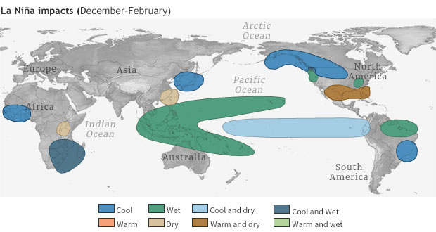
One important global impact of La Niña is its effect on the Atlantic hurricane season. La Niña reduces wind shear—the change in winds between the surface and the upper levels of the atmosphere—allowing hurricanes to grow. The likelihood of La Niña was factored into NOAA’s August outlook for the Atlantic hurricane season, which favored an “extremely active” season. As of September 8th, we have seen 17 named storms so far this season, and the forecast is for a total of 19-25 named storms (the hurricane season ends on Nov. 30th).
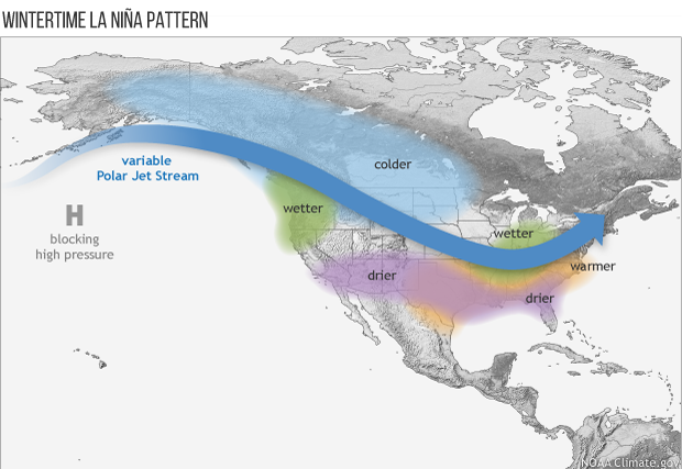
La Niña affects US weather through its impact on the Asia-North Pacific jet stream, which is retracted to the west during a La Niña winter and often shifted northward of its average position. Tom wrote a great explanation of the La Niña/jet stream mechanics and impacts here. Generally, La Niña winters in the southern tier of the US tend to be warmer and drier, while the northern tier and Canada tend to be colder. Official seasonal outlooks are available from the Climate Prediction Center, and Nat will be writing about CPC’s winter outlook for the blog in November.
We have a bunch of information on La Niña impacts here on the ENSO Blog! In the early stages of our last La Niña, 2018–2019, Tom mapped out the temperature and precipitation during every La Niña winter on record. Also, guest posts have covered La Niña’s effect on snow in the US, a potential link with tornado season, and how La Niña can interact with other climate variability patterns. And of course, we’ll be here every month, updating you on how ENSO conditions are evolving.
La Niña likely past peak, but influence continues
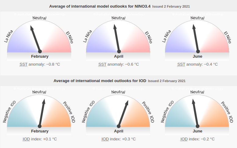
Courtesy BOM – The 2020–21 La Niña is likely to have peaked with respect to atmospheric and oceanic patterns in the tropical Pacific. However impacts associated with La Niña, such as above average rainfall in eastern and northern Australia, are expected to persist into early autumn, with climate outlooks indicating above average rainfall is likely for parts of these regions, particularly over northern Queensland.
Over the past fortnight the sea surface temperatures across Pacific Ocean basin have warmed by around 0.2 °C. The 90-day Southern Oscillation Index (SOI) has decreased slightly but continues to remain well above the La Niña threshold of +7, and trade winds have returned to near-average strength in the central tropical Pacific. Model outlooks indicate a return to neutral conditions (neither El Niño nor La Niña) during the late southern summer or early autumn.
The Southern Annular Mode (SAM) is positive, but is expected to tend towards neutral values over the next fortnight. The Madden–Julian Oscillation (MJO) is currently located over the western Pacific Ocean. Its influence on Australia is expected to weaken during the next fortnight as it moves east into the central Pacific. However, active tropical weather may persist across northern Australia due to other regional weather factors.
Climate change is also influencing the Australian climate. Australia’s climate has warmed by 1.44 ± 0.24 °C over the period 1910–2019, while recent decades have seen increased rainfall across northern Australia during the northern wet season (October–April), with more high-intensity, short-duration rainfall events.
What does it mean for South Africa?
Source: SAWS – “The El Niño-Southern Oscillation (ENSO) is currently in a La Niña state and the forecast indicates that it will most likely remain in a strong La Niña state during the end of summer. With this likelihood of a strong La Niña during late-summer, there are increased chances of above-normal rainfall in the summer rainfall areas.
The multi-model rainfall forecast for late-summer (Jan-Feb-Mar) and early-autumn (Feb-Mar-Apr) indicate wetter conditions over most of the country, most notably the summer rainfall areas. This indicates that the models have once again reverted to the Nov 2020 indication of a typical La Niña influence.
Minimum temperatures are expected to be variable throughout late summer and early autumn but mostly cooler during early autumn and warmer during mid-autumn (Mar-Apr-May). Maximum temperatures are expected to be below-normal for most of the country during the forecast period, again reverting to the mostly expected influence of a La Niña state.
The South African Weather Service will continue to monitor and provide updates on any future assessments that may provide more clarity on the current expectations for the coming seasons.”
Increased rainfall- LaNina events are associated with increased rainier-than-normal conditions.
Catastrophic Floods- If history serves us well, Southern Africa might witness another version of sorrow in this coming season. LaNina events are also known to cause disastrous floods, for example following the strong LaNina in 2010, Queensland Australia experienced the worst floods ever. This is a clear indication of how devastating LaNina can be.
Join our AfriWX Telegram Weather Group
Don’t forget to join the free AfriWX group on Telegram Messenger, please download Telegram for Android or iPhone if you want to always be up to date with the latest weather maps.
Click to join our Telegram Group

