Last Updated on 18th November 2019 10:31 AM by AfriWX
GFS Climate Model Data
Good morning South Africa. Our latest GFS climate model data is showing some favourable conditions for some rainfall this week starting today.
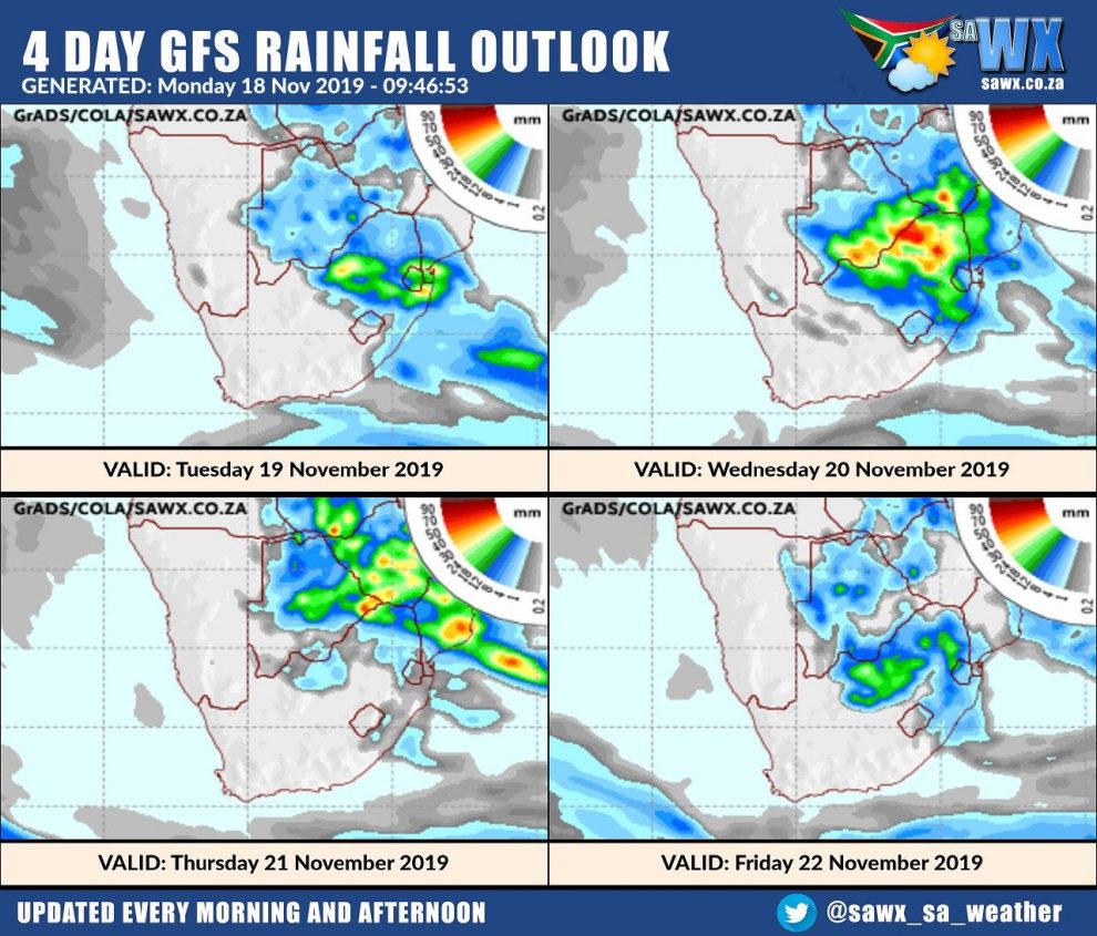
Currently model data is indicating the most favoured areas will be Gauteng, the North West Province, Limpopo and Mpumalanga provinces, Northern and Eastern Free State and Northern Kwazulu-Natal. This appears to be starting from today through to Friday if the models stay on track this time but it is indeed looking quite good so far. Conditions are also looking very favourable for Botswana, Zimbabwe and Mozambique.
Starting off the week
Here is the latest GFS model run for today. As you can see today Mpumalanga is favoured for the most heavy rain with a watch in place for severe storms today on the Western Highveld of Mpumalanga.


GFS Rainfall for the rest of this week
Let’s take a look now at the rest of the week and what the GFS climate models are showing us.
As you can see the North East of the country looks very favourable to thunderstorms, severe weather and heavy rain with possible flooding in places.
Flooding is always a word that comes with both relief and fear for some. Relief meaning we need this rain this week and exactly where it is currently showing it will rain and fear meaning sometimes lives are sadly lost due to flooding incidents.
This rain will help to fill up critically low dam levels as it is all situated very nicely over the catchment areas for Limpopo, Gauteng, Mpumalanga and the Free State.
Let’s hope the weather stays on track this week and we really do now need this rain so that our farmers can start planting. For those farmers that have already planted this rain will be very welcome to help get the new crops on their way to maturity.

GFS Rainfall for the Next 14 days
Let’s take a look at what the GFS climate models are showing for the next 14 days.
Right now the week 1 window (this week) is looking far more favourable than the second week window (next week).
This does not mean that next week is looking bad, it just means that right now, with current data, it’s not looking as favourable. This is why we tend to only look at the above maps spanning 1-5 days as the models change rapidly.

SAWX Rainfall Maps
Our own rainfall maps (below) which are created using an ensemble (combination) of Climate data are also showing very favourable rainfall ahead for this week.


10 Day GFS Rainfall Outlook
Lastly here is the latest GFS Climate Model outlook for the next 10 days.
We hope you get rain where you live.
Don’t forget to join our SAWX and Storm Watch Facebook groups and to share your photos and weather reports with us on Facebook.


Stel belang.