Last Updated on 24th March 2024 7:15 PM by AfriWX
THE REGIONAL WEATHER FORECAST
FOR TOMORROW 2024-03-25
ISSUED AT 1600 SAST
BY THE SOUTH AFRICAN WEATHER SERVICE. THIS FORECAST WILL BE UPDATED AT 0500 SAST.
SEVERE WEATHER ALERTS
IMPACT-BASED
WARNINGS
====================== A. Orange Level 5 Warning Disruptive Rain resulting in flooding of roads and settlements, damage to property and infrastructure, danger to life, displacement of affected communities and major disruption of traffic flow due to major roads being flooded or being closed is expected over the extreme north-eastern parts of KwaZulu-Natal, the escarpment and Lowveld of Mpumalanga and the extreme southern Lowveld of Limpopo. B. Yellow Level 2 Warning Disruptive Rain resulting in localised flooding of susceptible formal and informal settlements and roads as well as difficult driving conditions and closure of roads crossing low water bridges are expected over the extreme eastern Highveld of Mpumalanga, the southern Lowveld and escarpment of Limpopo and the north-eastern interior of KwaZulu-Natal. C. Yellow Level 1 Warning Damaging Winds and Waves resulting in small vessels taking on water and difficulty in navigation at sea is expected offshore between Algoa Bay and Port Edward. FIRE DANGER
WARNINGS
===================== Nil. ADVISORIES =========== Nil.
PROVINCIAL WEATHER OVERVIEW
GAUTENG PROVINCE
=========== Cloudy and cool to warm with isolated showers and thundershowers from the afternoon. The expected UVB sunburn Index Moderate
MPUMALANGA PROVINCE
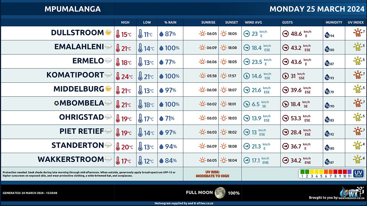
============== Cloudy and cool to cold with isolated to scattered showers and thundershowers but widespread in the east. It will be warm in the Lowveld.
LIMPOPO PROVINCE
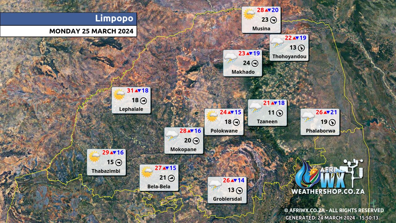
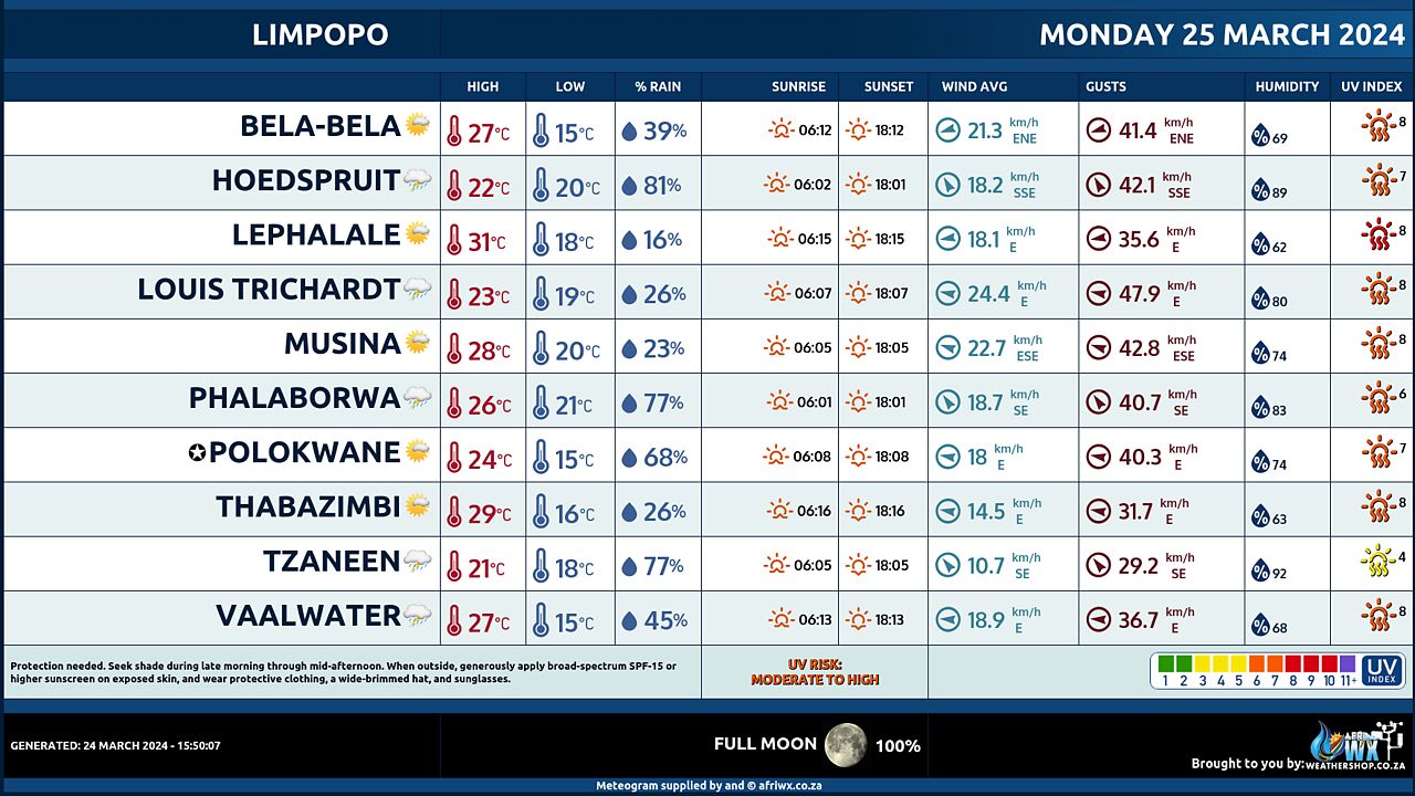
=========== Cloudy and warm with isolated to scattered showers and thundershowers, except in the west, but widespread in the extreme southern Lowveld.
NORTH-WEST PROVINCE
Partly cloudy and warm with isolated showers and thundershowers in the extreme east.
FREE STATE
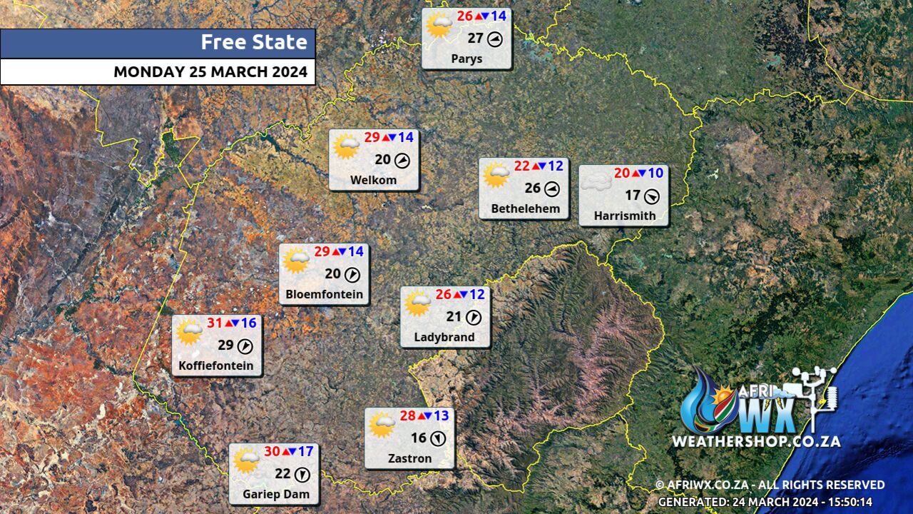
============== Morning fog patches in the east where it will be cool, otherwise partly cloudy and warm with isolated showers and thundershowers over the eastern parts.
NORTHERN CAPE
================= Partly cloudy, windy and warm to hot with isolated showers and thundershowers, except in the extreme west and north- east, but scattered in the south-east. It will be cool along the coast. The wind along the coast will be light and variable in the morning, otherwise fresh to strong southerly to south- easterly.
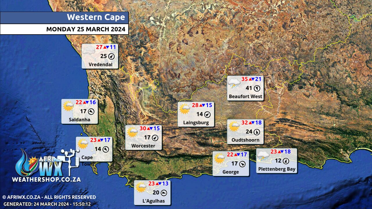
WESTERN CAPE
================ Cloudy in the south-east at first, otherwise partly cloudy and warm to hot with isolated showers and thundershowers over the eastern parts but scattered in the north-east. It will be cool along the south and south-west coast. The wind along the coast will be moderate to fresh north- westerly but strong south of Table Bay. It will become moderate to fresh southerly between Strandfontein and Cape Agulhas from the evening while moderate to fresh easterly along the south coast from the afternoon. The expected UVB sunburn Index Very High
WESTERN HALF OF THE EASTERN CAPE
============= Warm along the coast, otherwise partly cloudy, windy and hot with scattered showers and thundershowers. The wind along the coast will be moderate to fresh north- easterly east of Cape St Francis in the morning, otherwise moderate to fresh westerly to south-westerly, but strong from the afternoon.
EASTERN HALF OF THE EASTERN CAPE
============= Morning mist in places, otherwise fine and warm to hot, becoming partly cloudy with isolated showers and thundershowers in the afternoon except along the Wild Coast. The wind along the coast will be moderate to fresh north- easterly, but strong to near gale force in the afternoon.
KWAZULU-NATAL
================== Cloudy and warm with isolated to scattered showers and thundershowers but widespread in the north-east. The wind along the coast will be fresh to strong easterly to north-easterly but near gale force south of Durban at times. The expected UVB sunburn Index Moderate
JOIN OUR FREE AFRIWX WEATHER GROUP on Telegram Messenger
Please download Telegram for Android or iPhone if you want to always be up to date with the latest weather maps.
CLICK HERE TO JOIN our Telegram Group Now
Maximum Temperatures Forecast for South Africa Monday 25 March 2024
Minimum Temperatures Forecast for South Africa Monday 25 March 2024
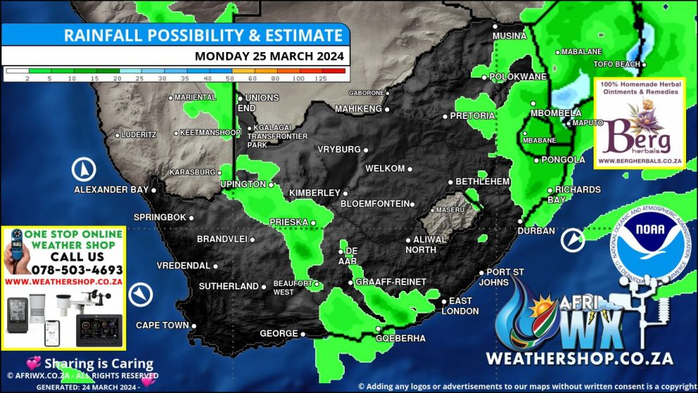
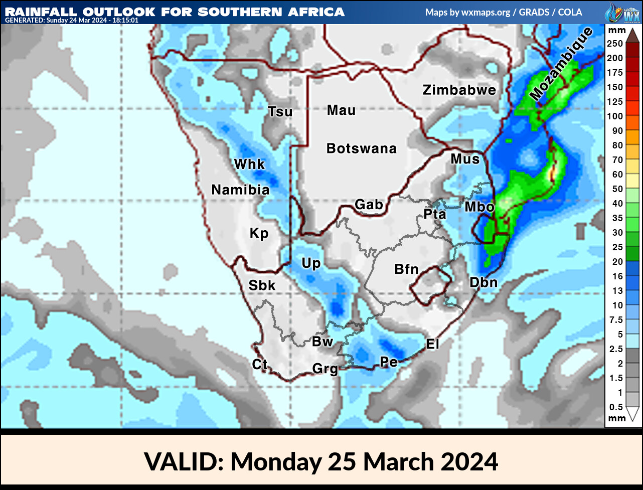
Rainfall Outlook for South Africa Monday 25 March 2024
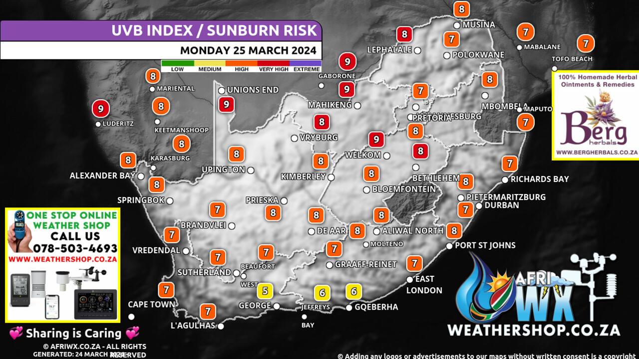
UVB Index Outlook for South Africa Monday 25 March 2024
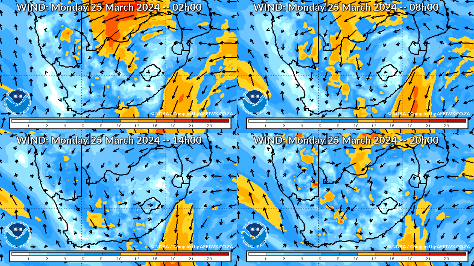
Wind Speed Direction and Gusts Map for South Africa Monday 25 March 2024
TRAVELLERS WEATHER FORECAST
FOR TOMORROW 2024-03-25
ISSUED AT 1500 SAST
BY THE SOUTH AFRICAN WEATHER SERVICE.
SEVERE WEATHER ALERTS
IMPACT-BASED
WARNINGS
====================== A.
Orange Level 5 Warning Disruptive Rain resulting in flooding of roads and settlements, damage to property and infrastructure, danger to life, displacement of affected communities and major disruption of traffic flow due to major roads being flooded or being closed is expected over the extreme north-eastern parts of KwaZulu-Natal, the escarpment and Lowveld of Mpumalanga and the extreme southern Lowveld of Limpopo.
B.
Yellow Level 2 Warning Disruptive Rain resulting in localised flooding of susceptible formal and informal settlements and roads as well as difficult driving conditions and closure of roads crossing low water bridges are expected over the extreme eastern Highveld of Mpumalanga, the southern Lowveld and escarpment of Limpopo and the north-eastern interior of KwaZulu-Natal.
C.
Yellow Level 1 Warning Damaging Winds and Waves resulting in small vessels taking on water and difficulty in navigation at sea is expected offshore between Algoa Bay and Port Edward.
FIRE DANGER
WARNINGS
===================== Nil.
ADVISORIES =========== Nil.
WEATHER IN OUR TOP CITIES
PRETORIA
========= Cloudy with isolated showers and thundershowers from the afternoon.
Minimum/Maximum 16/26 The expected UVB Sunburn Index Moderate
JOHANNESBURG
============= Cloudy with isolated showers and thundershowers from the afternoon.
Minimum/Maximum 15/24
VEREENIGING
============ Cloudy with isolated showers and thundershowers from the afternoon.
Minimum/Maximum 15/25
MBOMBELA
========= Cloudy with widespread showers and thundershowers.
Minimum/Maximum 15/22
POLOKWANE
========== Cloudy with isolated showers and thundershowers from the afternoon.
Minimum/Maximum 16/25
MAHIKENG
========= Partly cloudy.
Minimum/Maximum 15/27
VRYBURG
======== Partly cloudy.
Minimum/Maximum 16/30
BLOEMFONTEIN
============= Partly cloudy.
Minimum/Maximum 12/30
KIMBERLEY
========== Partly cloudy.
Minimum/Maximum 16/31
UPINGTON
========= Partly cloudy with isolated showers and thundershowers.
Minimum/Maximum 22/34
CAPE TOWN
========== Partly cloudy.
Wind Moderate northerly to north-westerly becoming moderate southerly from the evening.
Minimum/Maximum 15/24 The expected UVB Sunburn Index Very High
GEORGE
======= Cloudy at first, otherwise partly cloudy with isolated showers and thundershowers towards the evening.
Wind Light to moderate north-westerly becoming moderate easterly from the afternoon.
Minimum/Maximum 17/23 GQEBERHA ========= Partly cloudy with scattered showers and thundershowers.
Wind Moderate to fresh north-easterly, becoming fresh to strong south-westerly from late morning.
Minimum/Maximum 20/26
EAST LONDON
============ Partly cloudy, becoming cloudy with isolated showers and thundershowers from the afternoon.
Wind Moderate to fresh north-easterly, reaching strong in the afternoon.
Minimum/Maximum 21/29
DURBAN
======= Cloudy with isolated showers and thundershowers.
Wind Fresh to strong easterly to north-easterly.
Minimum/Maximum 22/27 The expected UVB Sunburn Index Extreme
RICHARDS BAY
============= Cloudy with widespread showers and thundershowers.
Wind Fresh to strong easterly to north-easterly.
Minimum/Maximum 23/28
PIETERMARITZBURG
================= Cloudy with isolated showers and thundershowers.
Minimum/Maximum 17/27
JOIN OUR FREE AFRIWX WEATHER GROUP on Telegram Messenger
Please download Telegram for Android or iPhone if you want to always be up to date with the latest weather maps.
CLICK HERE TO JOIN our Telegram Group Now
Rainfall Outlook for Tomorrow Monday 25 March 2024
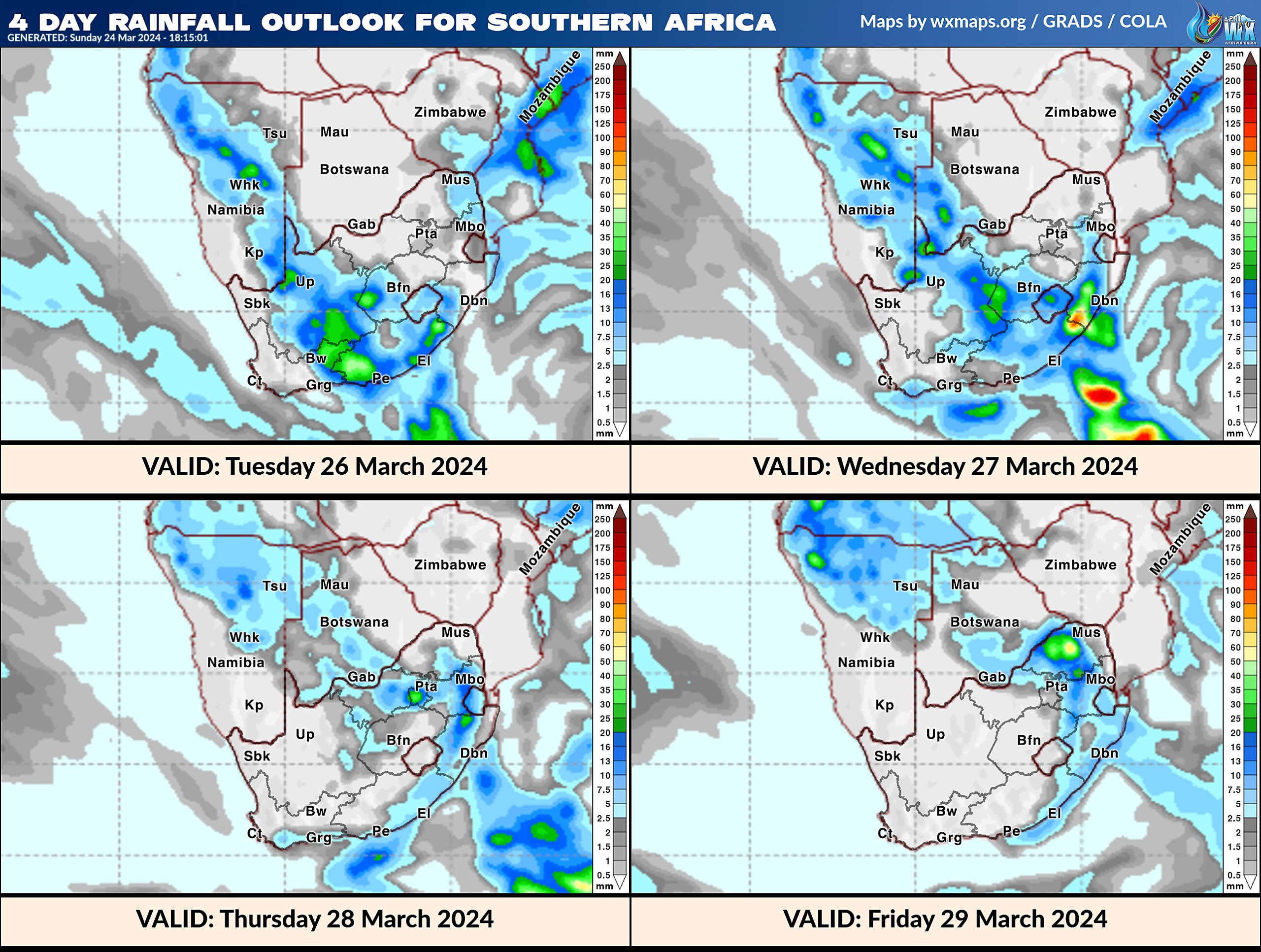
4 Day Rainfall Outlook for Southern Africa
14 Day Rainfall Outlook for Southern Africa
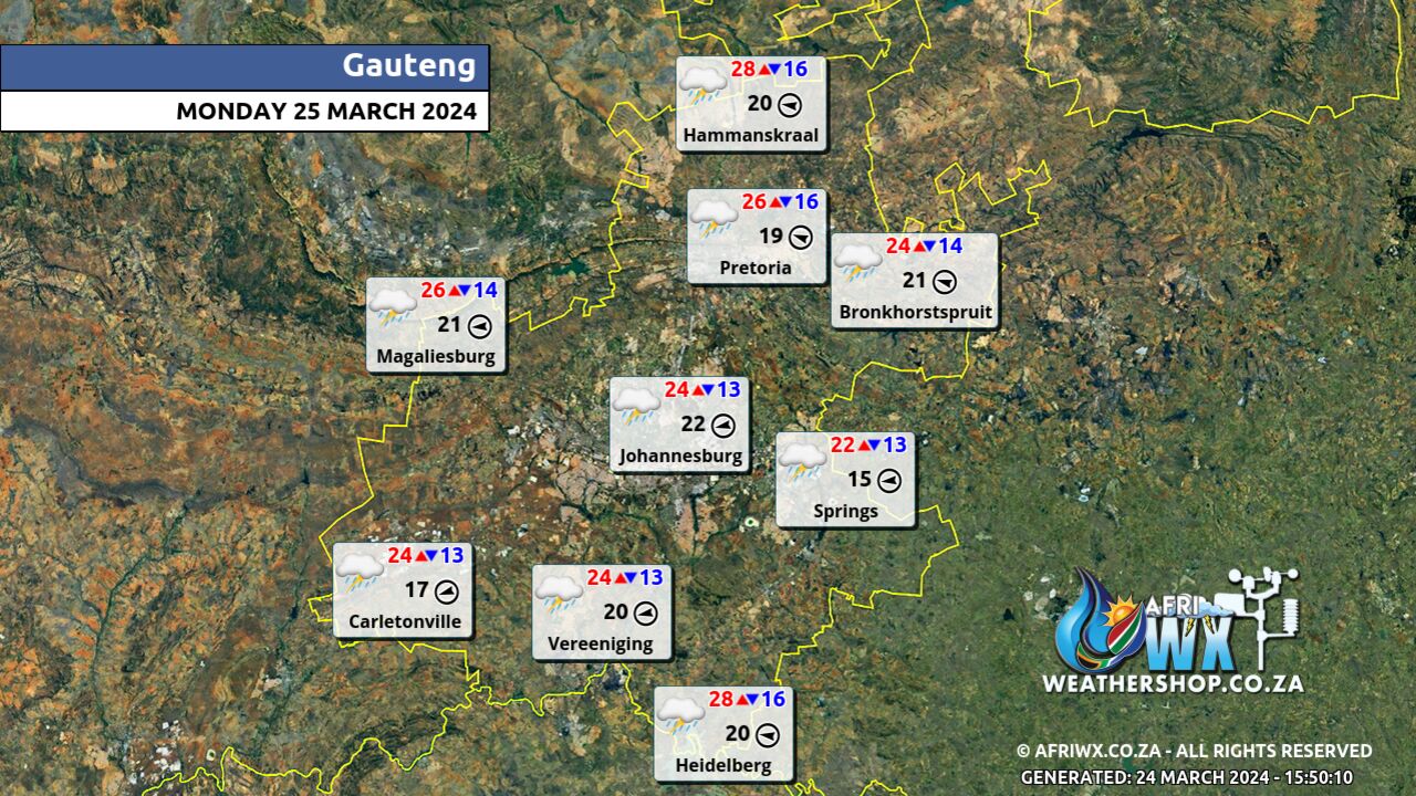
Gauteng Province Weather Map Monday 25 March 2024
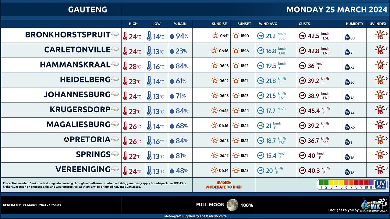
Gauteng Province Weather Meteogram Monday 25 March 2024
Kwazulu-Natal Province Weather Map Monday 25 March 2024
Kwazulu-Natal Province Weather Meteogram Monday 25 March 2024
Eastern Cape Province Weather Map Monday 25 March 2024
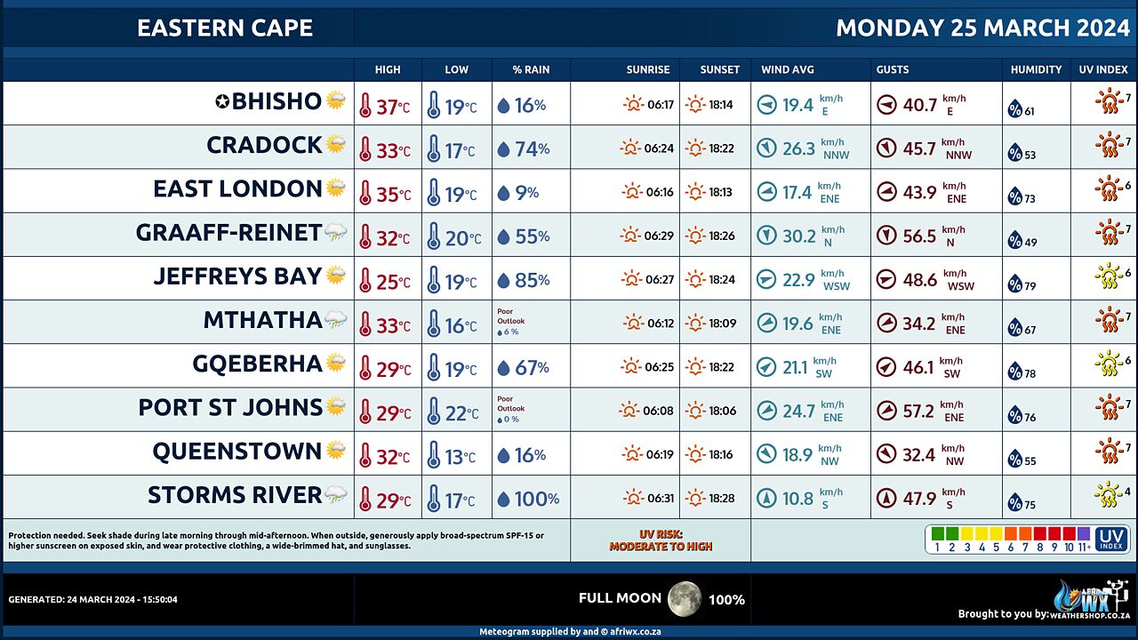
Eastern Cape Province Weather Meteogram Monday 25 March 2024
Western Cape Province Weather Map Monday 25 March 2024
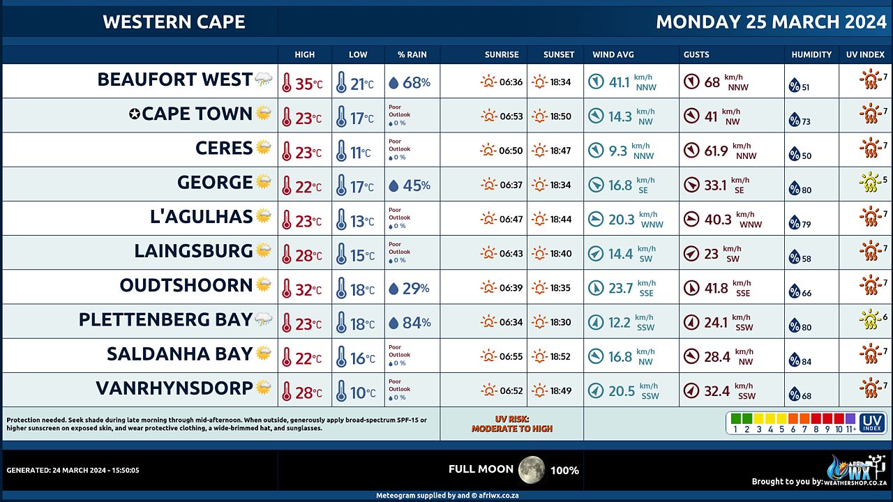
Western Cape Province Weather Meteogram Monday 25 March 2024
Northern Cape Province Weather Map Monday 25 March 2024
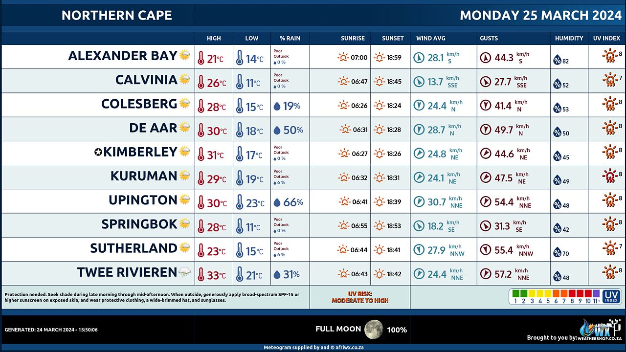
Northern Cape Province Weather Meteogram Monday 25 March 2024
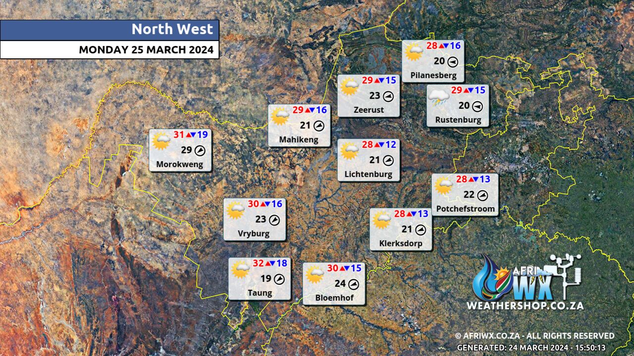
North-West Province Weather Map Monday 25 March 2024
North-West Province Weather Meteogram Monday 25 March 2024
Limpopo Province Weather Map Monday 25 March 2024
Limpopo Province Weather Meteogram Monday 25 March 2024
Mpumalanga Province Weather Map Monday 25 March 2024
Mpumalanga Province Weather Meteogram Monday 25 March 2024
Free State Province Weather Map Monday 25 March 2024
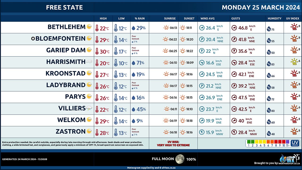
Free State Province Weather Meteogram Monday 25 March 2024
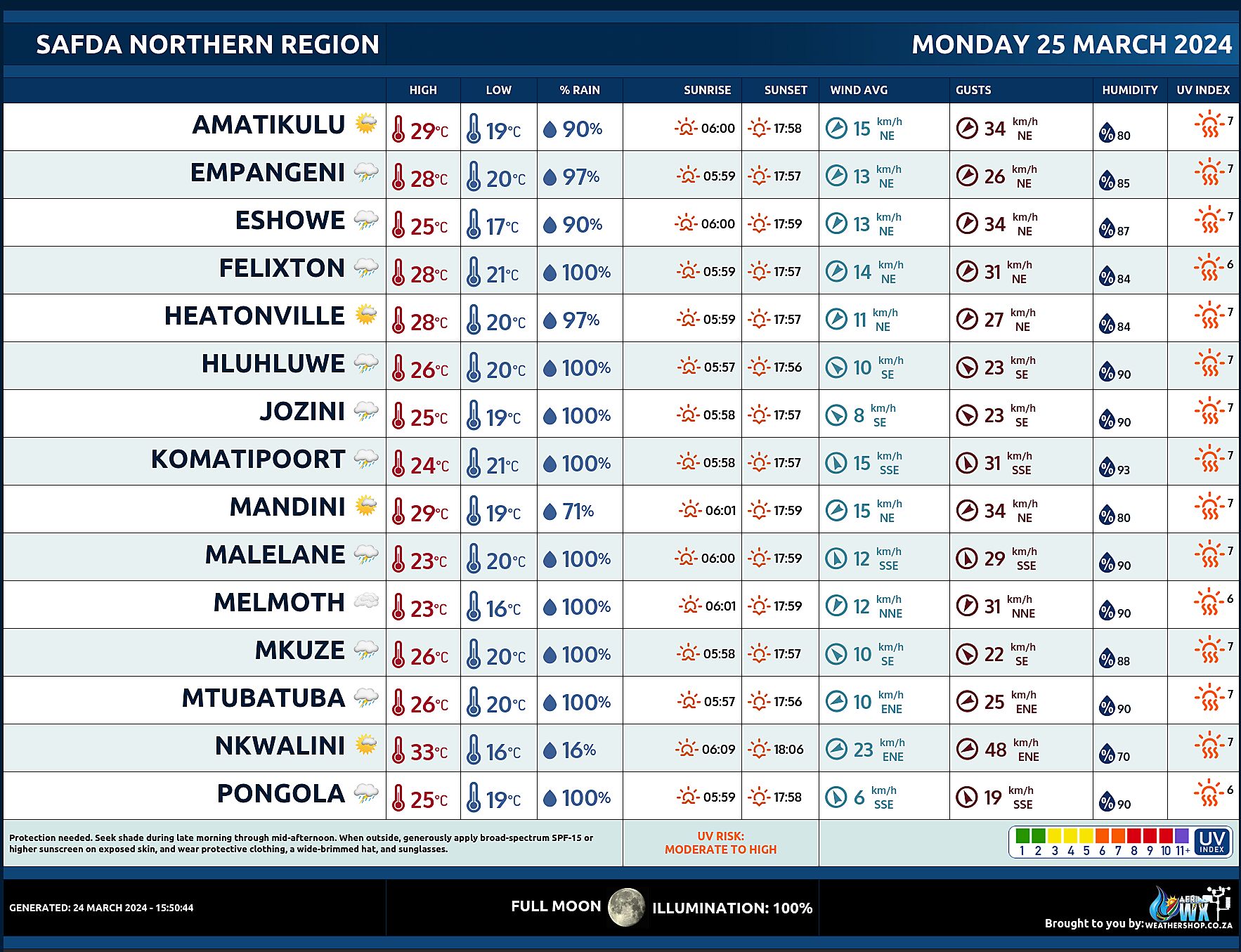
SAFDA Sugar Cane Farming (Northern Kwazulu-Natal) Weather Forecast Monday 25 March 2024
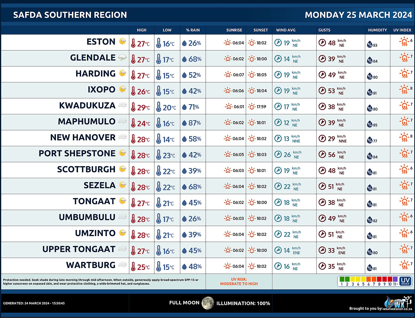
SAFDA Sugar Cane Farming (Southern Kwazulu-Natal) Weather Forecast Monday 25 March 2024
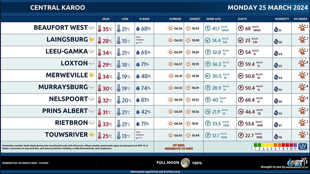
Central Karoo (Northern Cape) Farming Weather Forecast Monday 25 March 2024
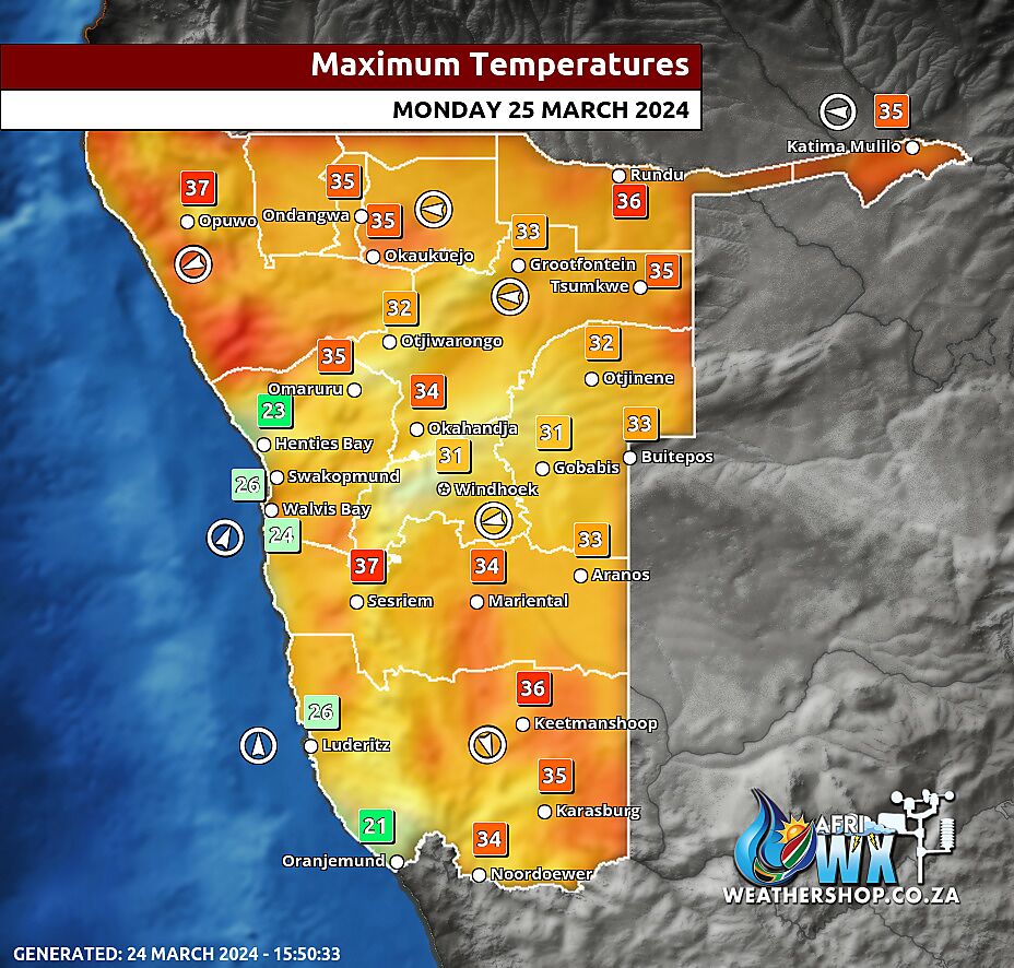
Namibia Maximum Temperatures Monday 25 March 2024
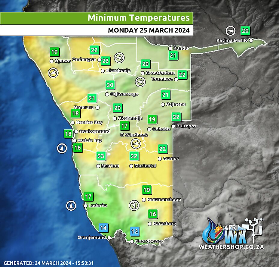
Namibia Minimum Temperatures Monday 25 March 2024
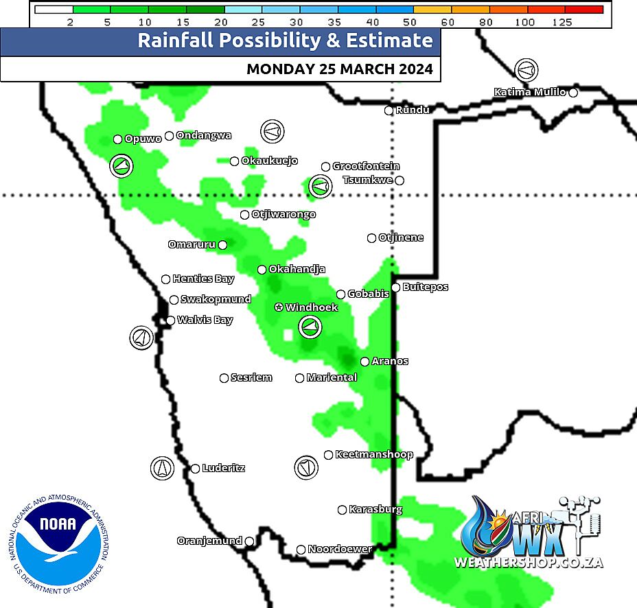
Namibia Rainfall Probability Map Monday 25 March 2024
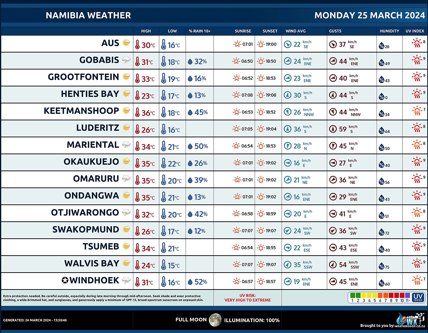
Namibia Weather Meteogram Monday 25 March 2024
Namibia Meteorological Services METEONA Weather Forecast Monday 25 March 2024
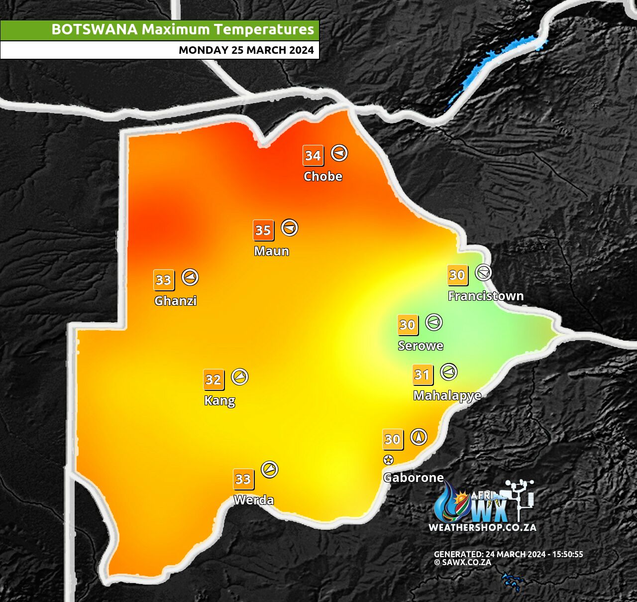
Botswana Maximum Temperatures Monday 25 March 2024
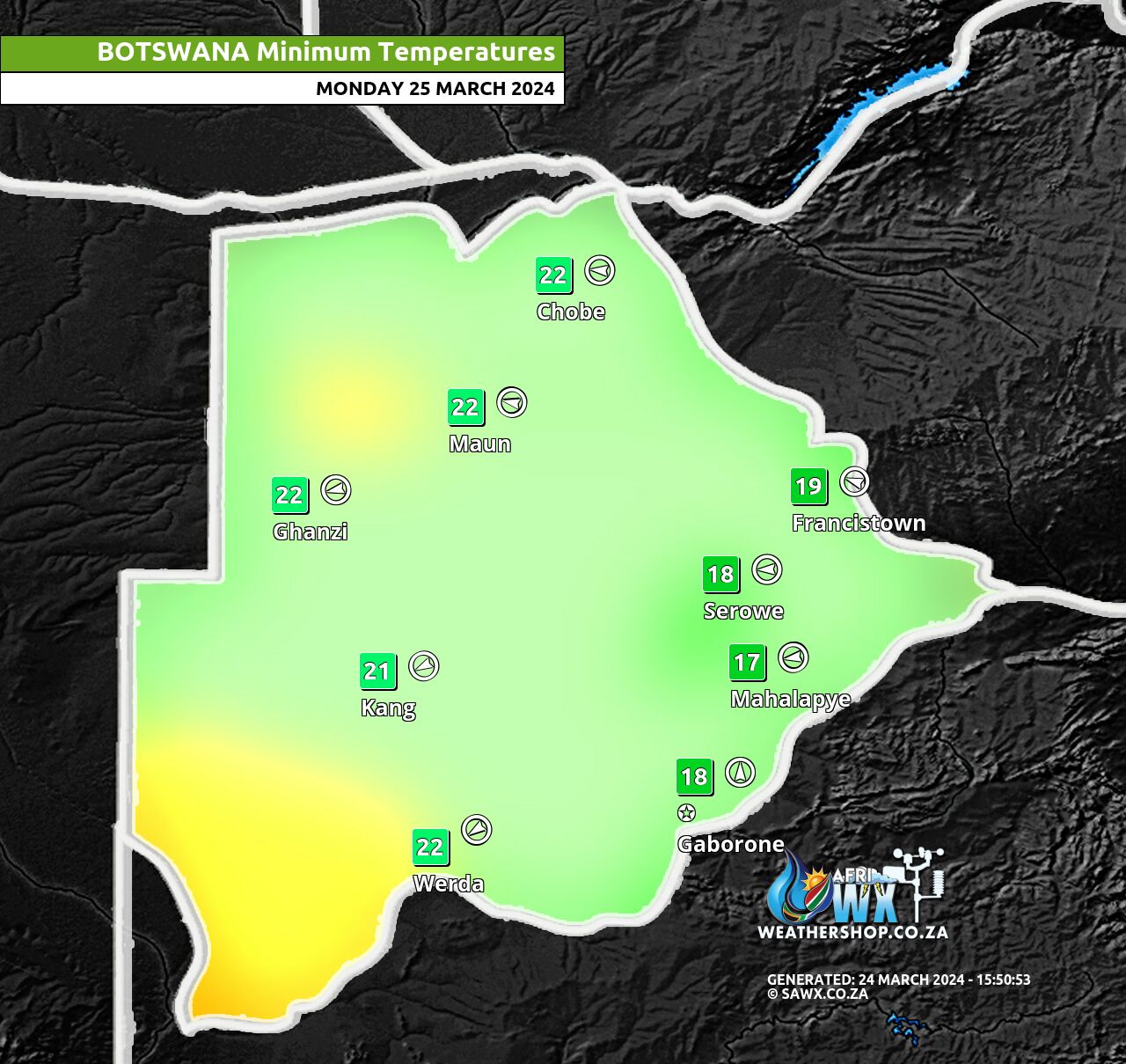
Botswana Minimum Temperatures Monday 25 March 2024
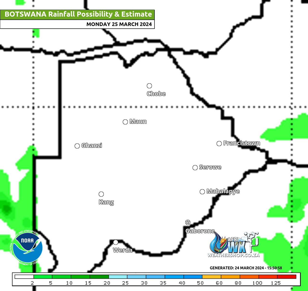
Botswana Rainfall Possibility Map Monday 25 March 2024
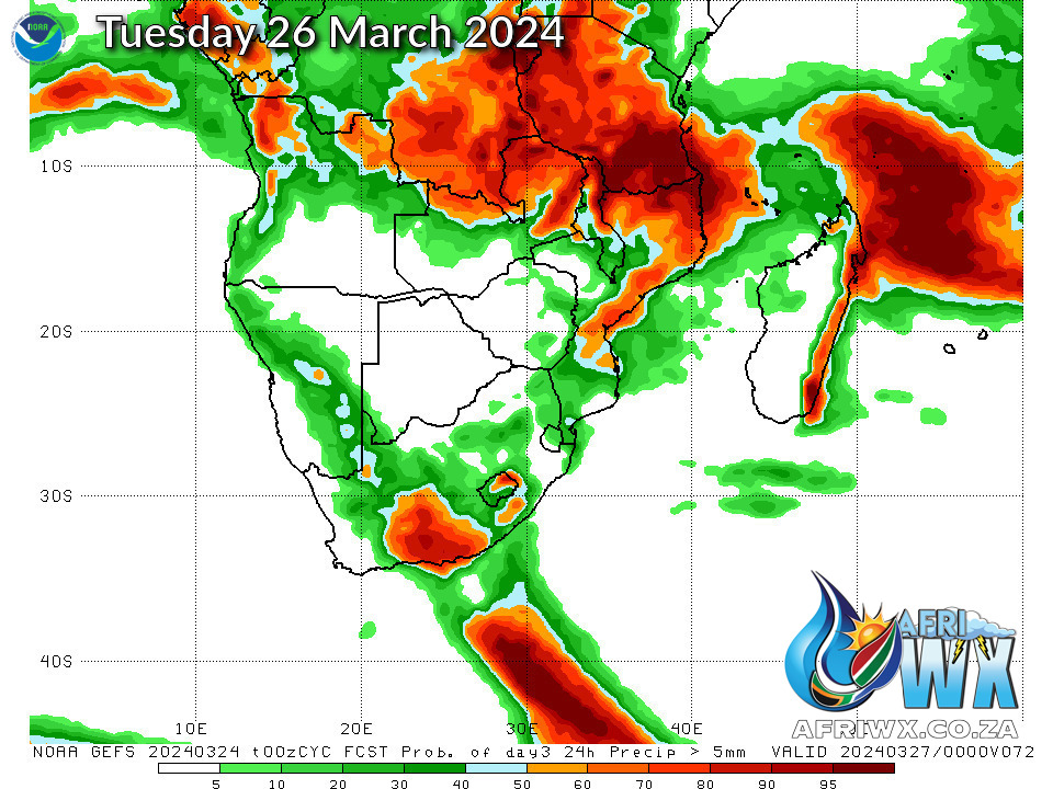
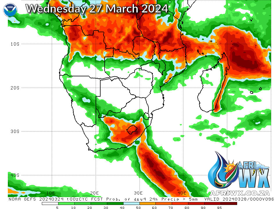
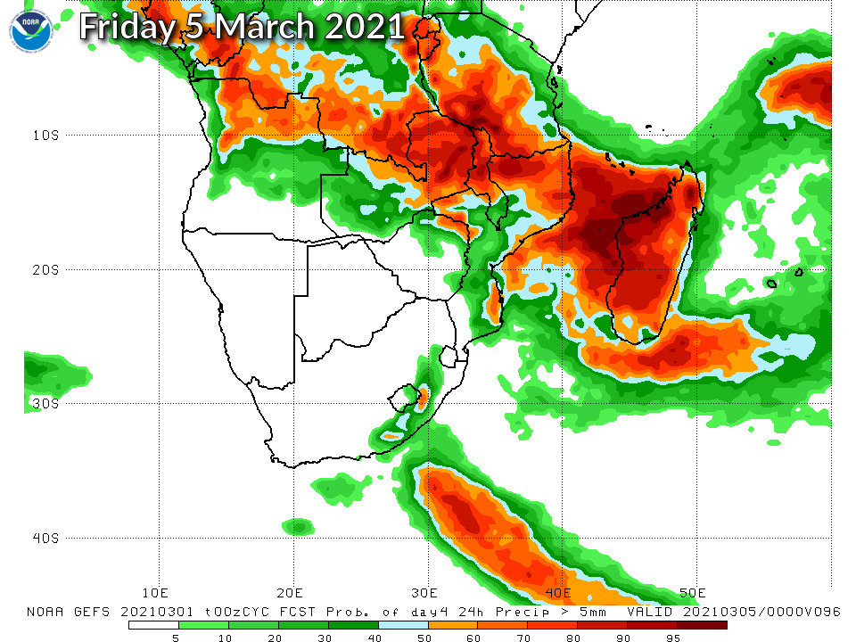
NOAA GEFS Global Ensemble Rainfall Outlook Southern Africa
JOIN OUR FREE AFRIWX WEATHER GROUP on Telegram Messenger
Please download Telegram for Android or iPhone if you want to always be up to date with the latest weather maps.
CLICK HERE TO JOIN our Telegram Group Now

