Last Updated on 22nd September 2023 6:45 PM by AfriWX
THE REGIONAL WEATHER FORECAST
FOR TOMORROW 2023-09-23
ISSUED AT 1600 SAST
BY THE SOUTH AFRICAN WEATHER SERVICE. THIS FORECAST WILL BE UPDATED AT 0500 SAST.
SEVERE WEATHER ALERTS
IMPACT-BASED
WARNINGS
====================== Impact Based Warnings for Tomorrow A. Yellow level 2 warning for severe thunderstorms leading to localised damage to settlements due to strong winds and large amounts of small hail is expected over the eastern parts of Northern Cape, western and central parts of Free State, western parts of the North-West province, as well as western parts of Kwa-Zulu Natal. Impact Based Warnings for Sunday into Monday A. Orange level 6 warning for Severe Thunderstorms leading to flooding and flash flooding is expected over the Garden Route, Overberg, southern Cape Winelands of the Western Cape from Sunday afternoon into Monday, but an orange level 6 warning for disruptive rain leading to flooding, danger to life and property over the Nelson Mandela Bay, Buffalo City, as well as the Koukamma, Kouga, Sundays River Valley, Ndlambe, Ngqushwa and Makana Local Municipalities of the Eastern Cape. B. Yellow level 2 warning for Severe Thunderstorms leading to localised flooding and flash flooding is expected over the Central Karoo, northern Cape Winelands, southern West Coast, City of Cape Town Western Cape from Sunday afternoon into Monday but a Yellow level 2 warning for disruptive rain leading to flooding, danger to life and property over the Sarah Baartman, Chris Hani, OR Tambo District Municipalities, as well as Walter Sisulu and Mbizana Local Municipalities of the Eastern Cape. C. Yellow level 2 warning for Wind and Waves leading to difficulty in navigation is expected between Cape Point and Cape Agulhas Western Cape from Sunday afternoon into Monday. D. Orange level 6 warning Wind and Waves leading to disruption of ports and small harbours is expected between Cape Agulhas and Plettenberg Bay Western Cape from Sunday afternoon into Monday. E. Yellow level 2 warning for Interior Winds leading to damage to properties, hazardous driving conditions and flying objects is expected from Sunday afternoon into Monday over the southern parts of Na! makwa of the Northern Cape, as well as the Central Karoo, Cape Winelands, western parts of the Overberg, City of Cape Town of the Western Cape as well as the over Chris Hani, Buffalo City, Amathole, OR Tambo, Joe Gqabi District Municipalities and Matatiele and Mbizana Local Municipalities of the Eastern Cape. F. Orange level 6 warning for Interior Winds leading to damage to properties, hazardous driving conditions and flying objects is expected from Sunday afternoon into Monday over the Garden Route, eastern Overberg and Langeberg municipality of the Western Cape but an orange level 5 warning expected over the western parts of the Eastern Cape. FIRE DANGER
WARNINGS
===================== A. Extremely high fire danger conditions are expected in places over the east of Northern Cape, North West province and in places over Free State, eastern parts of the North West Province, south-eastern Northern Cape, extreme south-western parts of Gauteng, northern and western parts of Limpopo, extreme northern parts of the Eastern Cape and places in the north of Kwa-Zulu Natal. ADVISORIES =========== A. An intense cut-off low is expected over the Cape Provinces, with very cold, wet and windy conditions expected over southern Namakwa in the Northern Cape and over the Western Cape province from Sunday afternoon until Monday morning. The public, marine users and small stock farmers are advised that disruptive rain, damaging winds, damaging waves, severe storms, and very cold temperatures are possible from Sunday evening into Tuesday over the Eastern Cape, with light snow possible over the high peaks of the north- eastern mountains.
PROVINCIAL WEATHER OVERVIEW
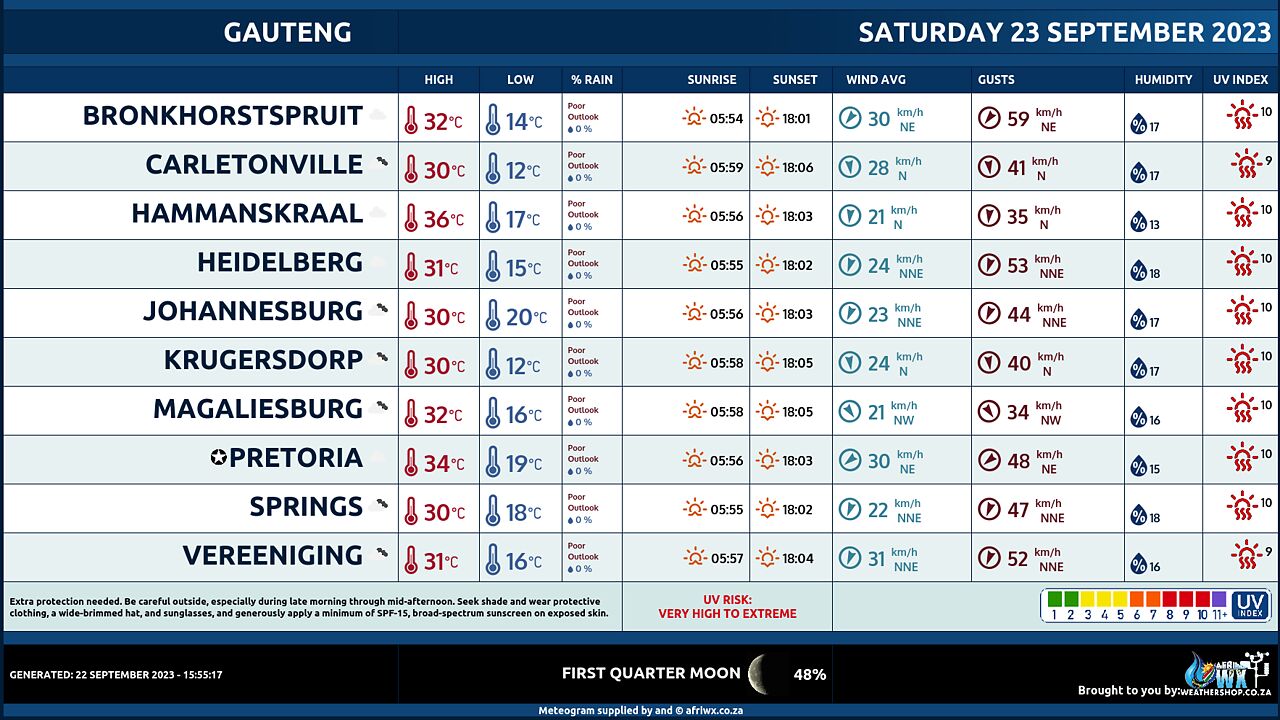
GAUTENG PROVINCE
– Fine and warm to hot, becoming Partly cloudy during the afternoon. The expected UVB sunburn Index Extreme
MPUMALANGA PROVINCE
Fine and warm to hot. It will become partly cloudy in the extreme south-west.
LIMPOPO PROVINCE
– Fine and hot to very hot. It will become partly cloudy with in the Highveld.
NORTH-WEST PROVINCE
– Cloudy to partly cloudy and hot, with isolated to scattered showers and thundershowers except over the eastern parts.
FREE STATE
– Fine and warm, with isolated showers and thundershowers, but scattered over the western and the central parts. 6. THE NORTHERN CAPE – Partly cloudy and warm to hot, with isolated to scattered showers and thundershowers in the east. The wind along the coast will be fresh to strong southerly to south- easterly.
WESTERN CAPE
Partly cloudy cool to cold, but cloudy in the south with isolated to scattered showers and rain along the south coast and adjacent interior. The wind along the coast will be fresh to strong southerly to south- easterly, but moderate southerly to south-westerly along the south coast. The expected UVB sunburn Index Moderate
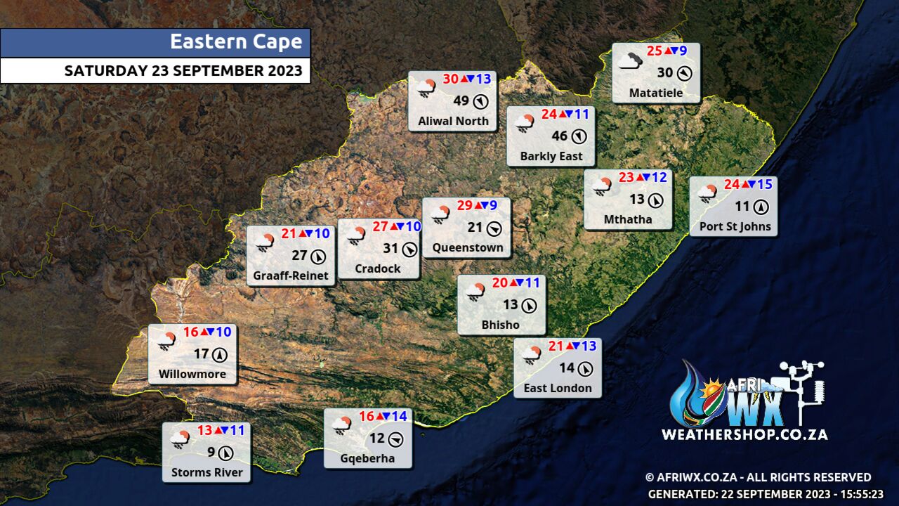
WESTERN HALF OF THE EASTERN CAPE
– Partly cloudy in the north at first, otherwise cloudy and cool with scattered showers and thundershowers, but isolated in the north-west The wind along the coast will be moderate south-westerly, becoming south- easterly east of Algoa bay in the afternoon.
EASTERN HALF OF THE EASTERN CAPE
Partly cloudy, windy and warm in the north, otherwise cloudy and cool with scattered afternoon showers and thundershowers, but isolated in the east. The wind along the coast will be moderate south-westerly, becoming south- easterly in the afternoon.
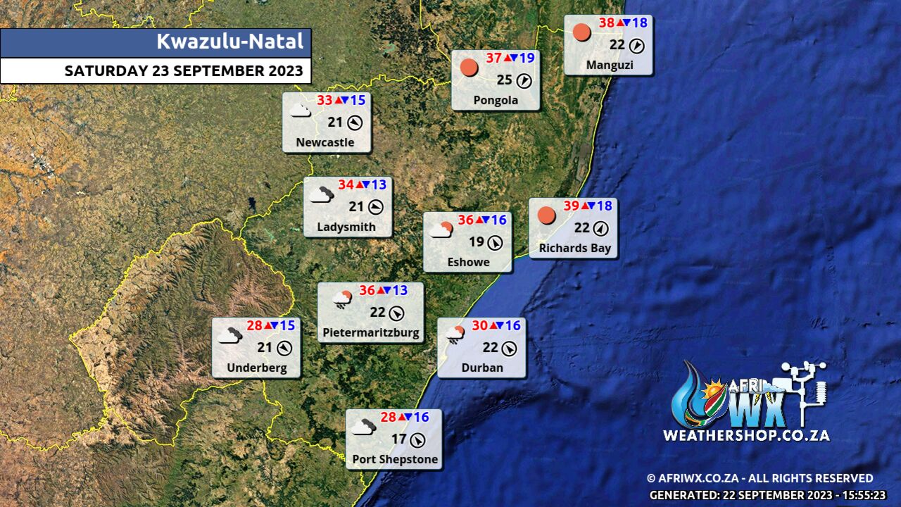
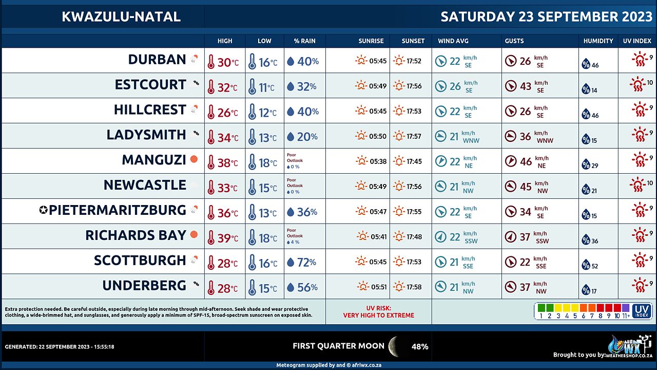
KWAZULU-NATAL
– Morning fog over the interior, otherwise partly cloudy and warm, but hot in places in the north, with isolated afternoon thundershowers in the west and south. It will be cloudy along the coast. The wind along the coast will be Moderate to fresh northerly to north- easterly, becoming southerly to south-westerly from the south by late morning, reaching north coast by evening. The expected UVB sunburn Index High OR
JOIN OUR FREE AFRIWX WEATHER GROUP on Telegram Messenger
Please download Telegram for Android or iPhone if you want to always be up to date with the latest weather maps.
CLICK HERE TO JOIN our Telegram Group Now
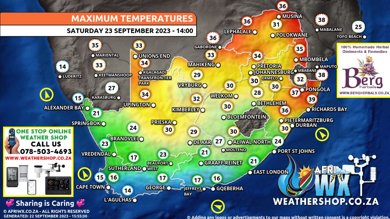
Maximum Temperatures Forecast for South Africa Saturday 23 September 2023
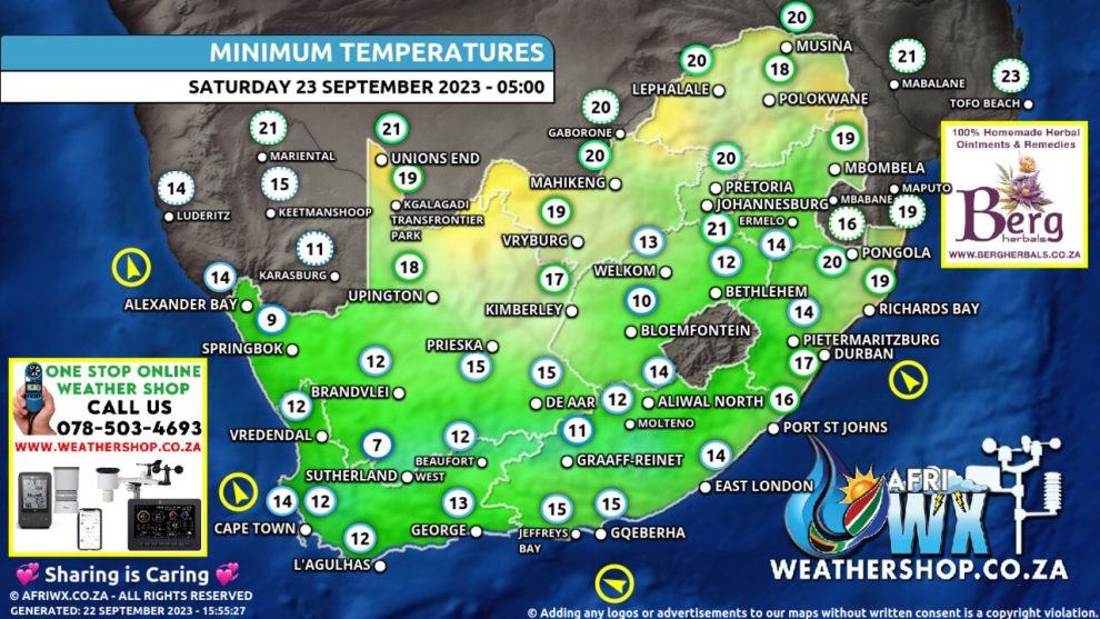
Minimum Temperatures Forecast for South Africa Saturday 23 September 2023
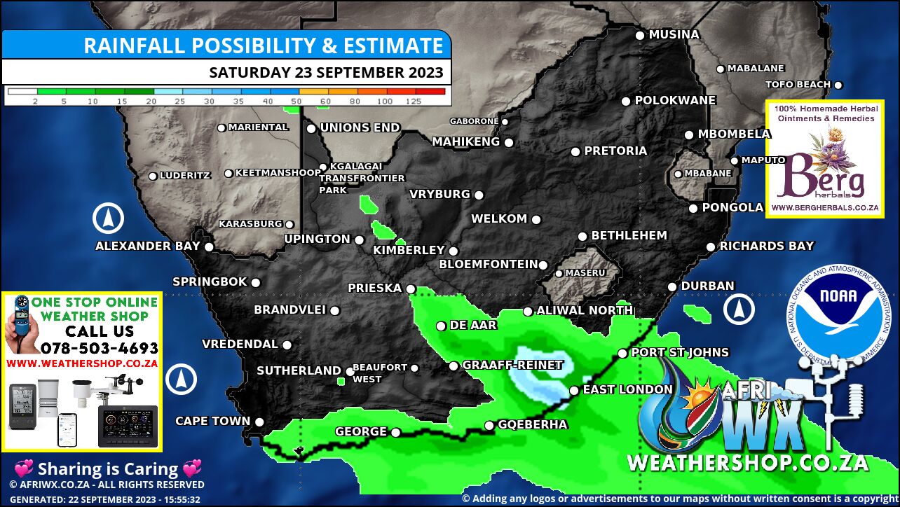
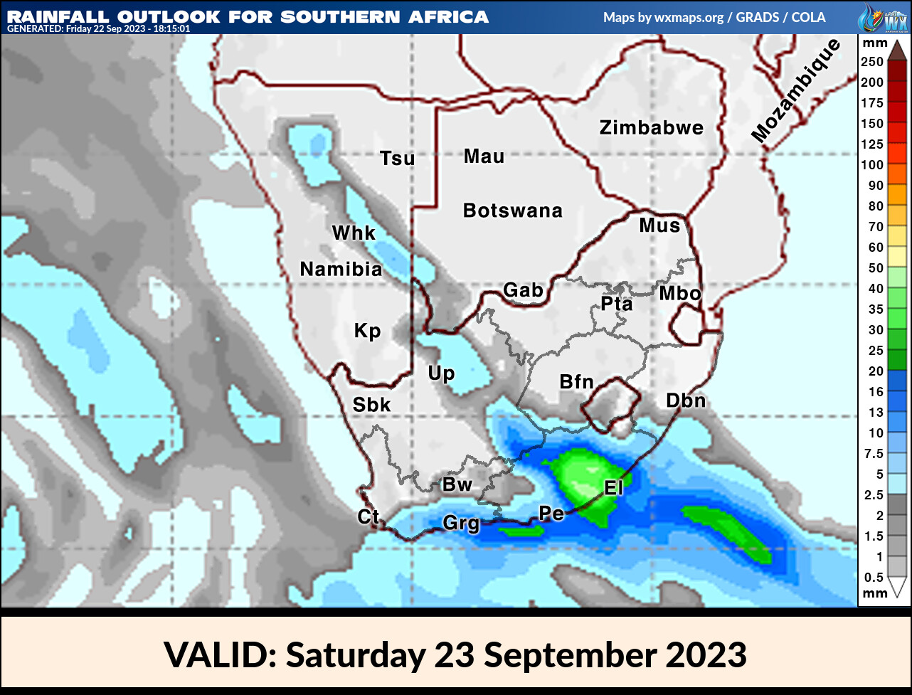
Rainfall Outlook for South Africa Saturday 23 September 2023
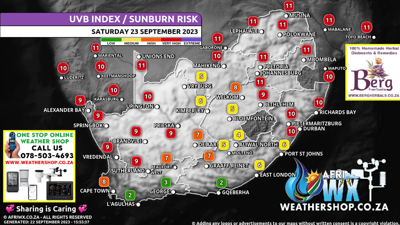
UVB Index Outlook for South Africa Saturday 23 September 2023
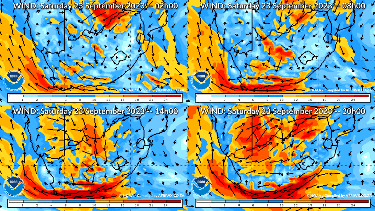
Wind Speed Direction and Gusts Map for South Africa Saturday 23 September 2023
TRAVELLERS WEATHER FORECAST
FOR TOMORROW 2023-09-23
ISSUED AT 1530 SAST
BY THE SOUTH AFRICAN WEATHER SERVICE.
SEVERE WEATHER ALERTS
IMPACT-BASED
WARNINGS
====================== Impact Based Warnings for Tomorrow A.
Yellow level 2 warning for severe thunderstorms leading to localised damage to settlements due to strong winds and large amounts of small hail is expected over the eastern parts of Northern Cape, western and central parts of Free State, western parts of the North-West province, as well as western parts of Kwa-Zulu Natal.
Impact Based Warnings for Sunday into Monday A.
Orange level 6 warning for Severe Thunderstorms leading to flooding and flash flooding is expected over the Garden Route, Overberg, southern Cape Winelands of the Western Cape from Sunday afternoon into Monday, but an orange level 6 warning for disruptive rain leading to flooding, danger to life and property over the Nelson Mandela Bay, Buffalo City, as well as the Koukamma, Kouga, Sundays River Valley, Ndlambe, Ngqushwa and Makana Local Municipalities of the Eastern Cape.
B.
Yellow level 2 warning for Severe Thunderstorms leading to localised flooding and flash flooding is expected over the Central Karoo, northern Cape Winelands, southern West Coast, City of Cape Town Western Cape from Sunday afternoon into Monday but a Yellow level 2 warning for disruptive rain leading to flooding, danger to life and property over the Sarah Baartman, Chris Hani, OR Tambo District Municipalities, as well as Walter Sisulu and Mbizana Local Municipalities of the Eastern Cape.
C.
Yellow level 2 warning for Wind and Waves leading to difficulty in navigation is expected between Cape Point and Cape Agulhas Western Cape from Sunday afternoon into Monday.
D.
Orange level 6 warning Wind and Waves leading to disruption of ports and small harbours is expected between Cape Agulhas and Plettenberg Bay Western Cape from Sunday afternoon into Monday.
E.
Yellow level 2 warning for Interior Winds leading to damage to properties, hazardous driving conditions and flying objects is expected from Sunday afternoon into Monday over the southern parts of Na! makwa of the Northern Cape, as well as the Central Karoo, Cape Winelands, western parts of the Overberg, City of Cape Town of the Western Cape as well as the over Chris Hani, Buffalo City, Amathole, OR Tambo, Joe Gqabi District Municipalities and Matatiele and Mbizana Local Municipalities of the Eastern Cape.
F.
Orange level 6 warning for Interior Winds leading to damage to properties, hazardous driving conditions and flying objects is expected from Sunday afternoon into Monday over the Garden Route, eastern Overberg and Langeberg municipality of the Western Cape but an orange level 5 warning expected over the western parts of the Eastern Cape.
FIRE DANGER
WARNINGS
===================== A.
Extremely high fire danger conditions are expected in places over the east of Northern Cape, North West province and in places over Free State, eastern parts of the North West Province, south-eastern Northern Cape, extreme south-western parts of Gauteng, northern and western parts of Limpopo, extreme northern parts of the Eastern Cape and places in the north of Kwa-Zulu Natal.
ADVISORIES =========== A.
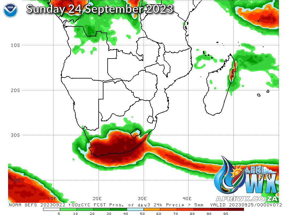
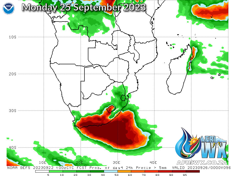
An intense cut-off low is expected over the Cape Provinces, with very cold, wet and windy conditions expected over southern Namakwa in the Northern Cape and over the Western Cape province from Sunday afternoon until Monday morning.
The public, marine users and small stock farmers are advised that disruptive rain, damaging winds, damaging waves, severe storms, and very cold temperatures are possible from Sunday evening into Tuesday over the Eastern Cape, with light snow possible over the high peaks of the north-eastern mountains.
WEATHER IN OUR TOP CITIES
PRETORIA
– Fine, becoming partly cloudy during the afternoon.
Minimum/Maximum 18/33 The expected UVB Sunburn Index Extreme
JOHANNESBURG
– Fine, becoming partly cloudy during the afternoon.
Minimum/Maximum 17/31 The expected UVB Sunburn Index Extreme
VEREENIGING
Fine, becoming partly cloudy during the afternoon.
Minimum/Maximum 15/32 The expected UVB Sunburn Index Extreme
MBOMBELA
– Fine.
Minimum/Maximum 19/32
POLOKWANE
– Fine.
Minimum/Maximum 16/32
MAHIKENG
– Fine.
Minimum/Maximum 19/31
VRYBURG
– Cloudy with scattered afternoon thundershowers.
Minimum/Maximum 15/29
BLOEMFONTEIN
– Cloudy with scattered afternoon thundershowers.
Minimum/Maximum 11/26
KIMBERLEY
– Cloudy with scattered afternoon thundershowers.
Minimum/Maximum 15/29
UPINGTON
Partly cloudy with isolated afternoon thundershowers Minimum/Maximum 15/31
CAPE TOWN
Partly cloudy Wind Moderate to fresh southerly to south-easterly, becoming strong in the afternoon.
Minimum/Maximum 11/17
GEORGE
Cloudy with scattered showers and rain WIND Moderate to fresh southerly to south-easterly Minimum/Maximum 11/16 GQEBERHA Cloudy with isolated to scattered showers and rain.
WIND Moderate south-westerly, becoming southerly midday.
Minimum/Maximum 13/19
EAST LONDON
Cloudy with light rain, becoming scattered to widespread showers in the afternoon.
Wind Light and variable, becoming moderate to fresh southerly in the afternoon.
Minimum/Maximum 15/20
DURBAN
Partly cloudy with isolated afternoon showers.
WIND Moderate northerly to north-easterly, becoming fresh southerly to south- westerly from late morning.
Minimum/Maximum 18/24
RICHARDS BAY
– Partly cloudy, becoming cloudy in the afternoon.
Wind Moderate to fresh northerly to north-easterly, becoming southerly to south-westerly towards evening.
Minimum/Maximum 18/30
PIETERMARITZBURG
– Morning fog, otherwise partly cloudy in the afternoon with isolated afternoon showers and thundershowers.
Minimum/Maximum 14/31 AND follow us on twitter at @saweatherservic
JOIN OUR FREE AFRIWX WEATHER GROUP on Telegram Messenger
Please download Telegram for Android or iPhone if you want to always be up to date with the latest weather maps.
CLICK HERE TO JOIN our Telegram Group Now
Rainfall Outlook for Tomorrow Saturday 23 September 2023
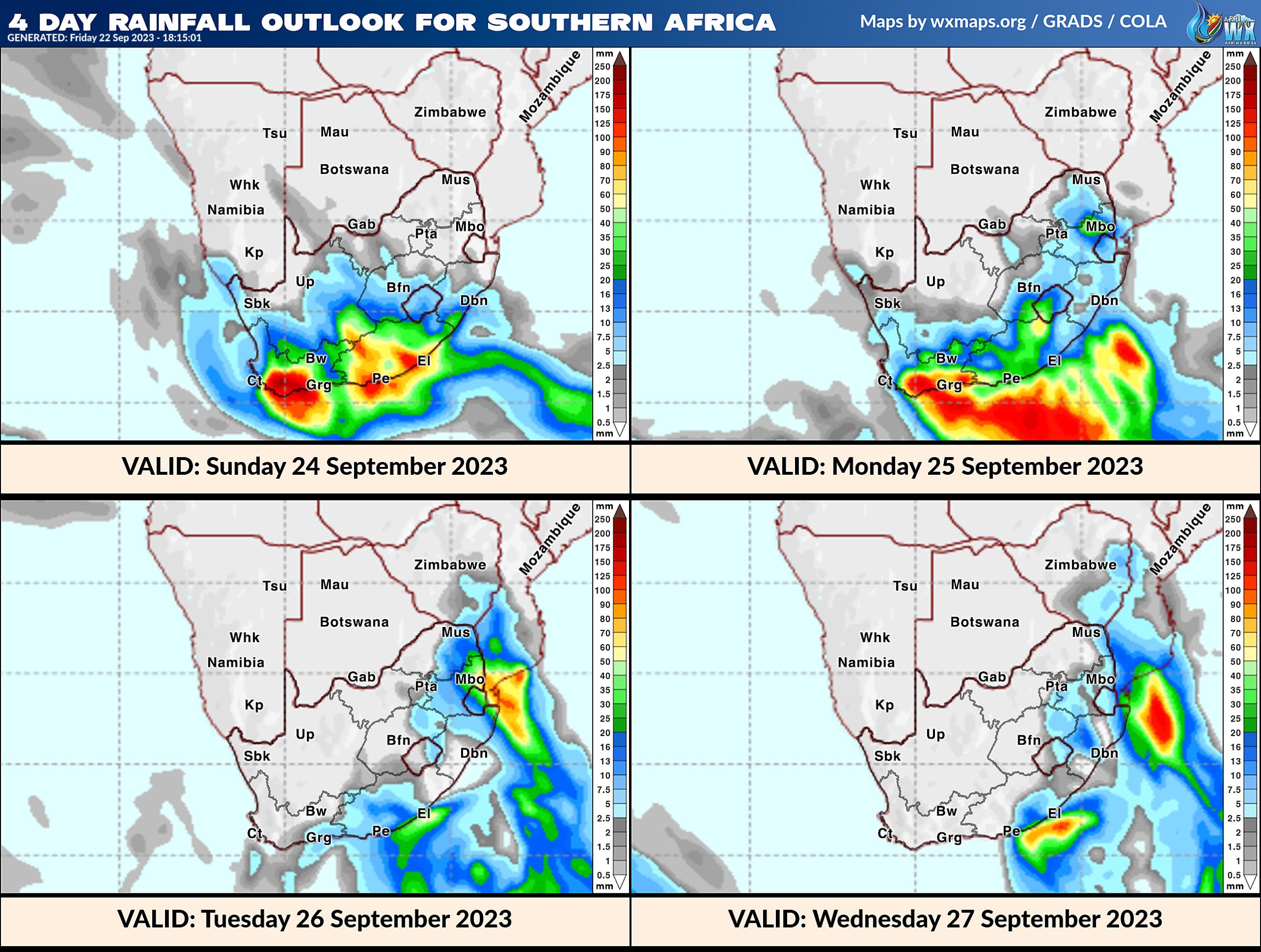
4 Day Rainfall Outlook for Southern Africa
14 Day Rainfall Outlook for Southern Africa
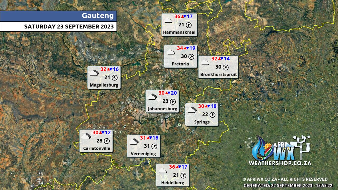
Gauteng Province Weather Map Saturday 23 September 2023
Gauteng Province Weather Meteogram Saturday 23 September 2023
Kwazulu-Natal Province Weather Map Saturday 23 September 2023
Kwazulu-Natal Province Weather Meteogram Saturday 23 September 2023
Eastern Cape Province Weather Map Saturday 23 September 2023
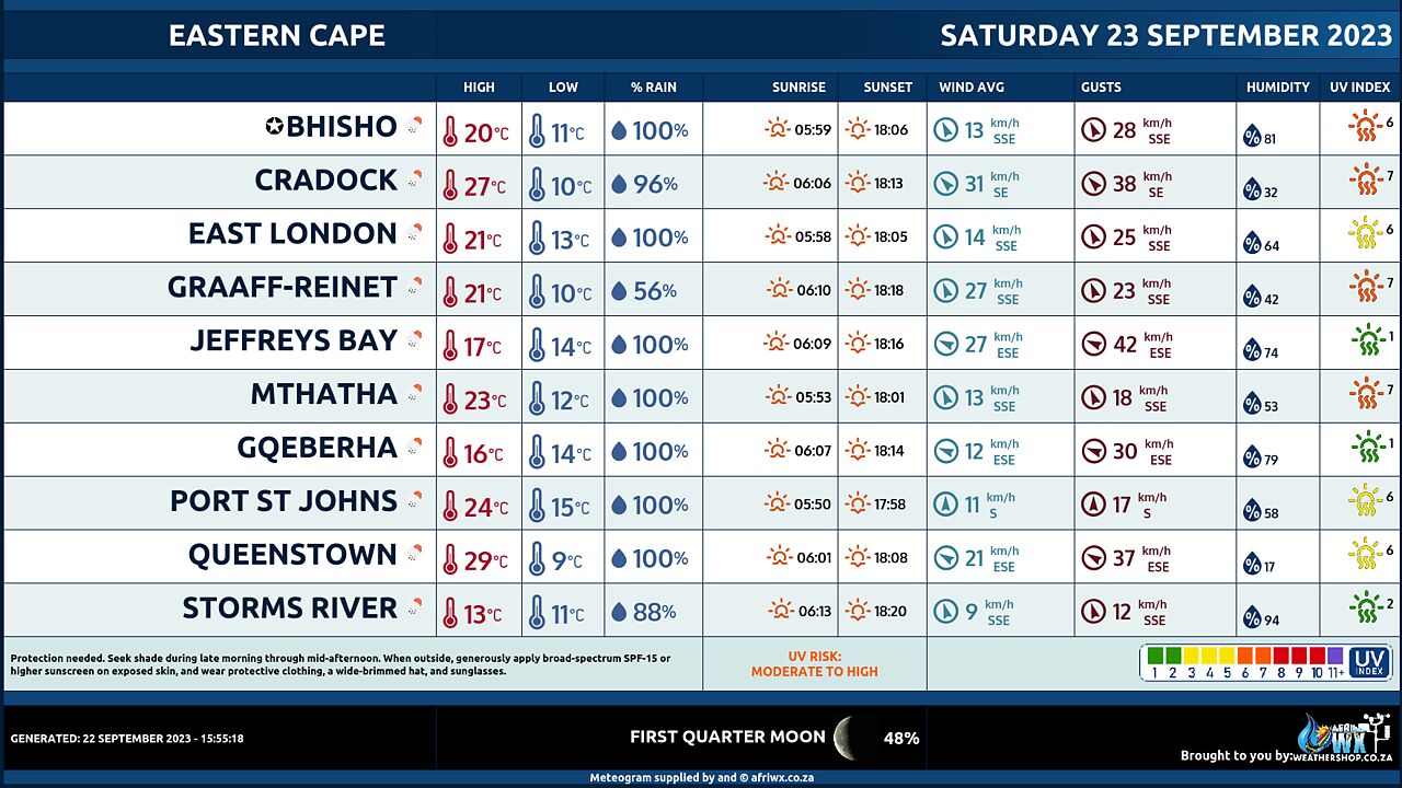
Eastern Cape Province Weather Meteogram Saturday 23 September 2023
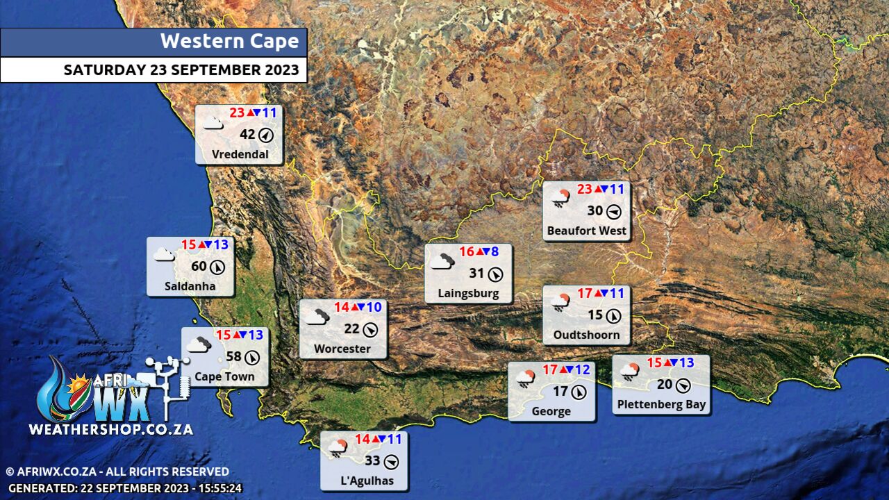
Western Cape Province Weather Map Saturday 23 September 2023
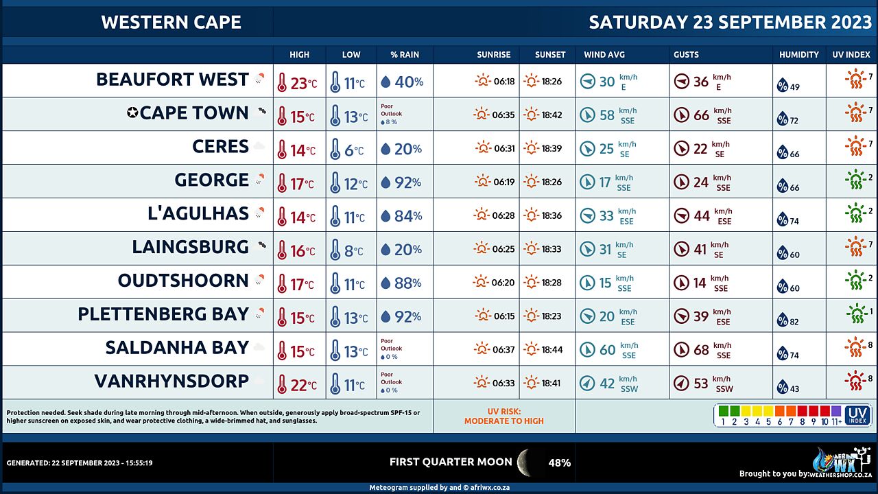
Western Cape Province Weather Meteogram Saturday 23 September 2023
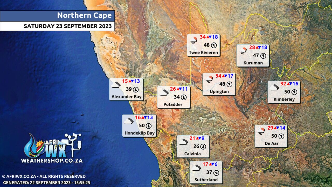
Northern Cape Province Weather Map Saturday 23 September 2023
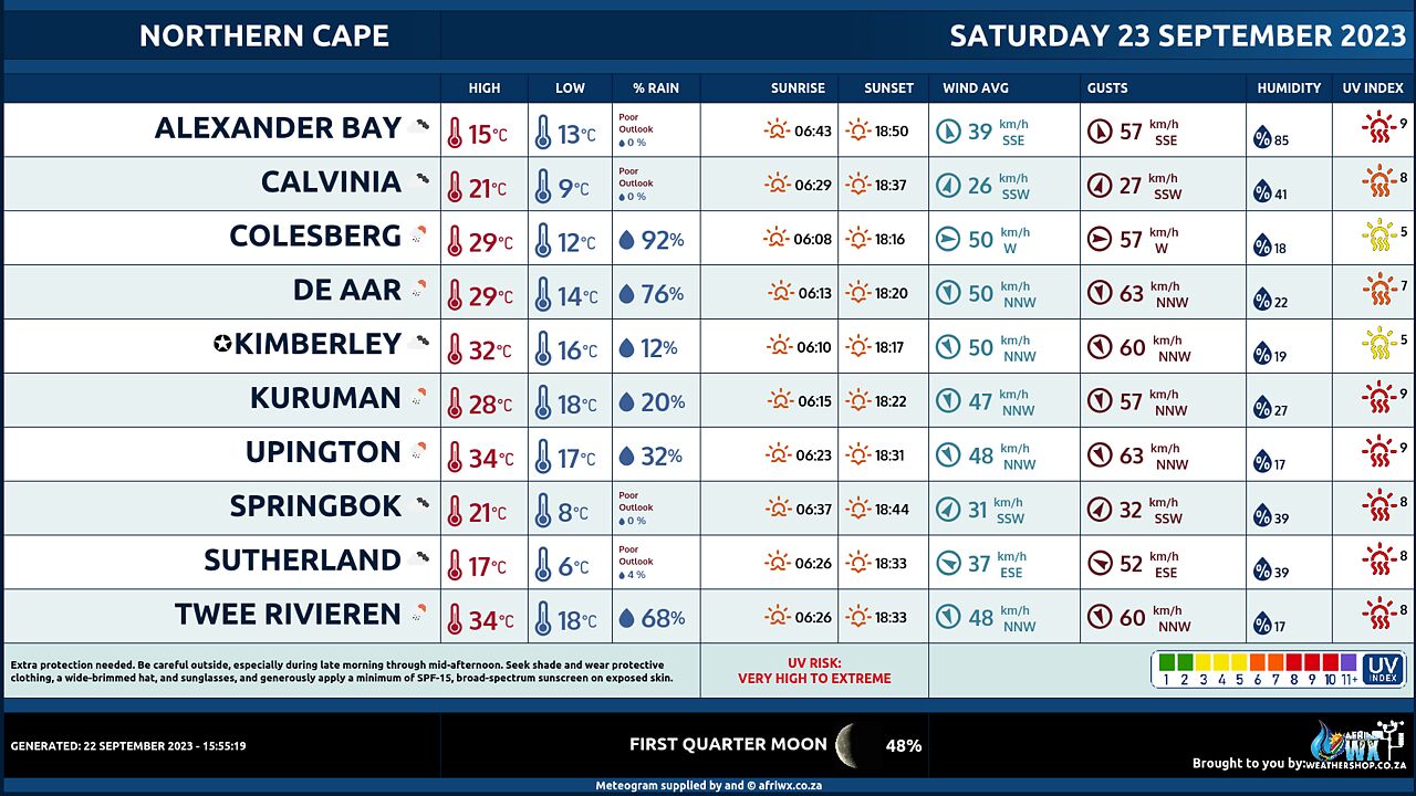
Northern Cape Province Weather Meteogram Saturday 23 September 2023
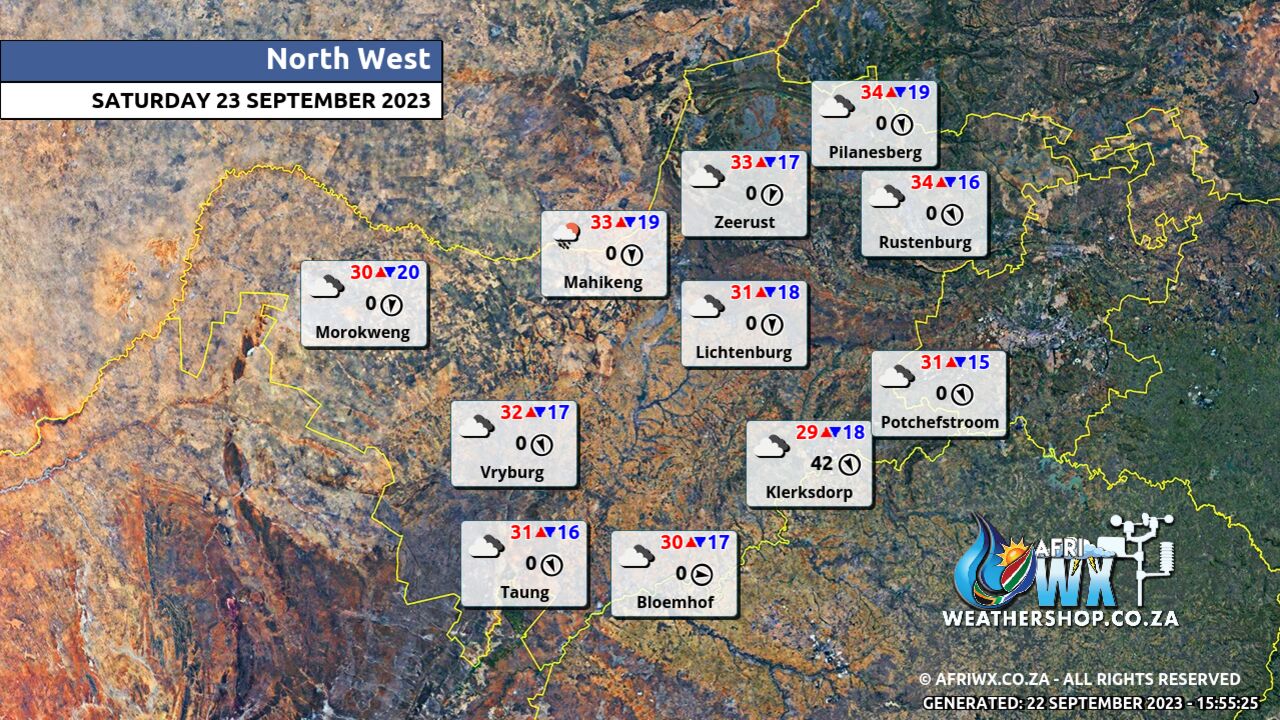
North-West Province Weather Map Saturday 23 September 2023
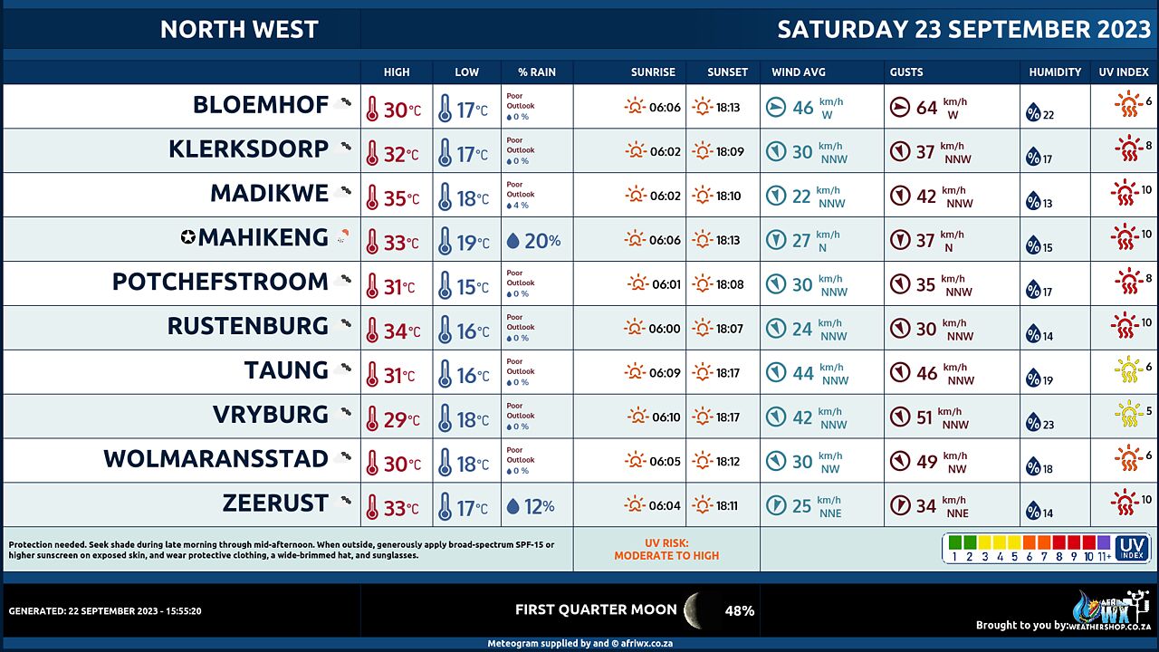
North-West Province Weather Meteogram Saturday 23 September 2023
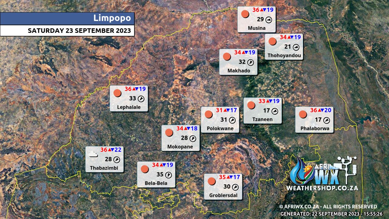
Limpopo Province Weather Map Saturday 23 September 2023
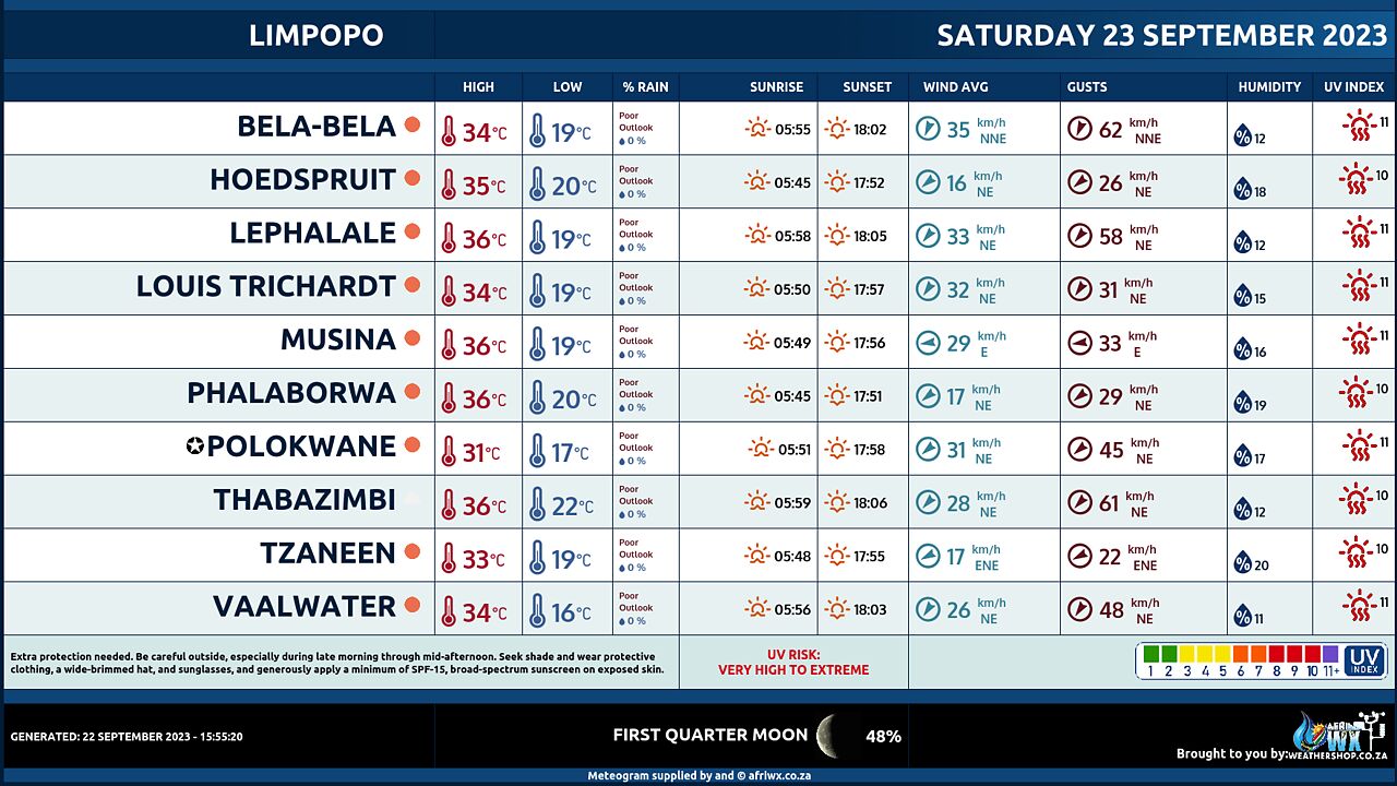
Limpopo Province Weather Meteogram Saturday 23 September 2023
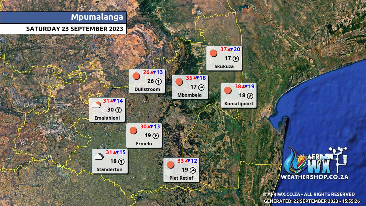
Mpumalanga Province Weather Map Saturday 23 September 2023
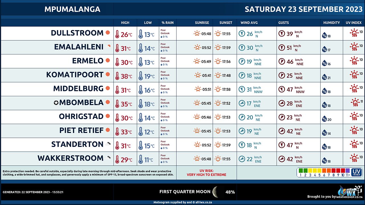
Mpumalanga Province Weather Meteogram Saturday 23 September 2023
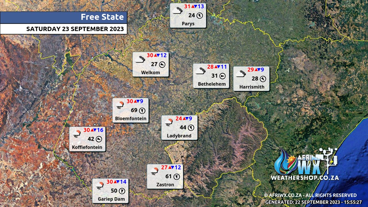
Free State Province Weather Map Saturday 23 September 2023
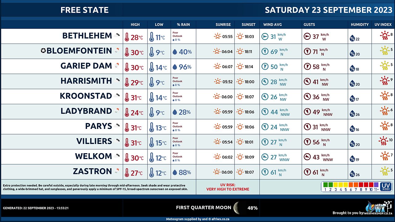
Free State Province Weather Meteogram Saturday 23 September 2023
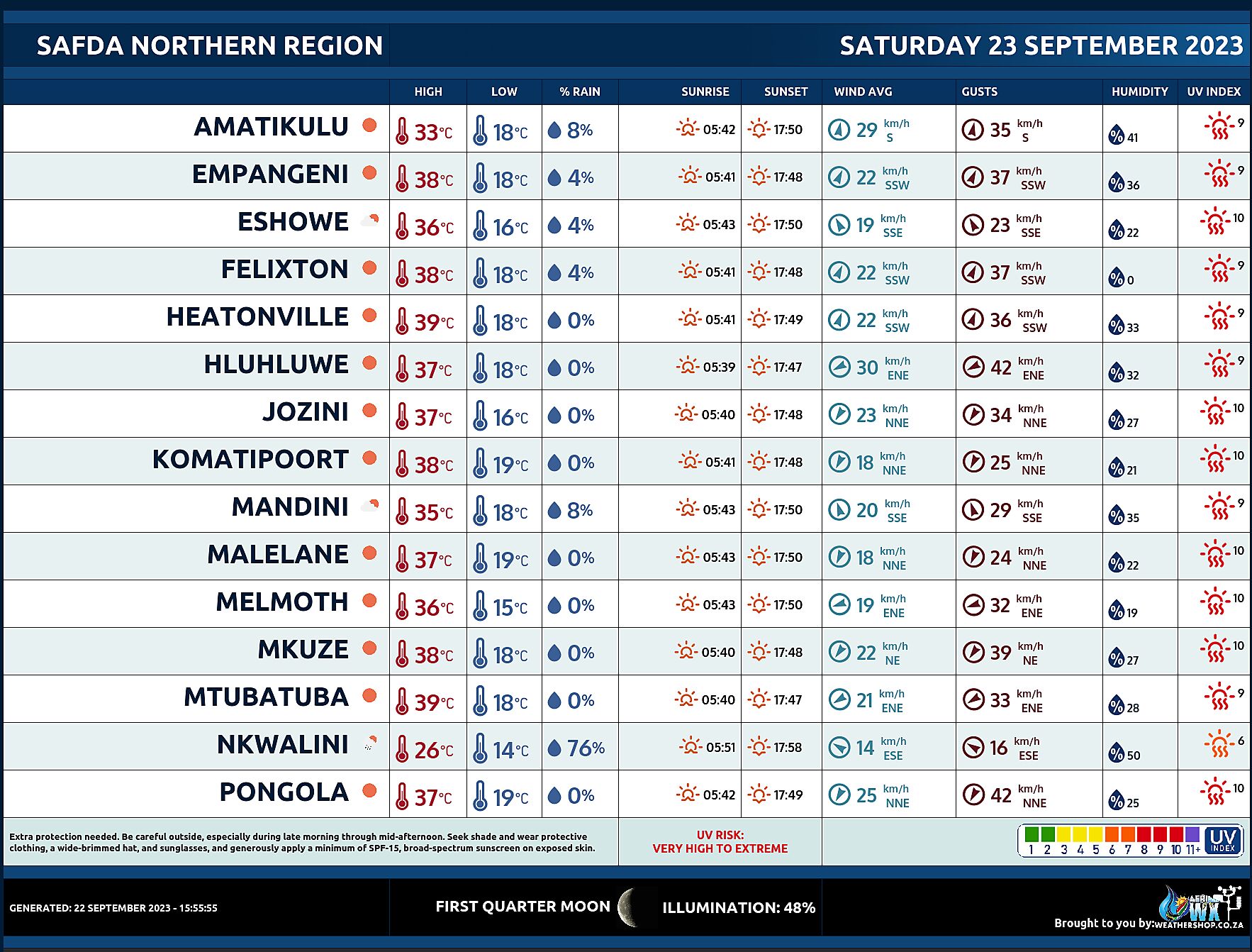
SAFDA Sugar Cane Farming (Northern Kwazulu-Natal) Weather Forecast Saturday 23 September 2023
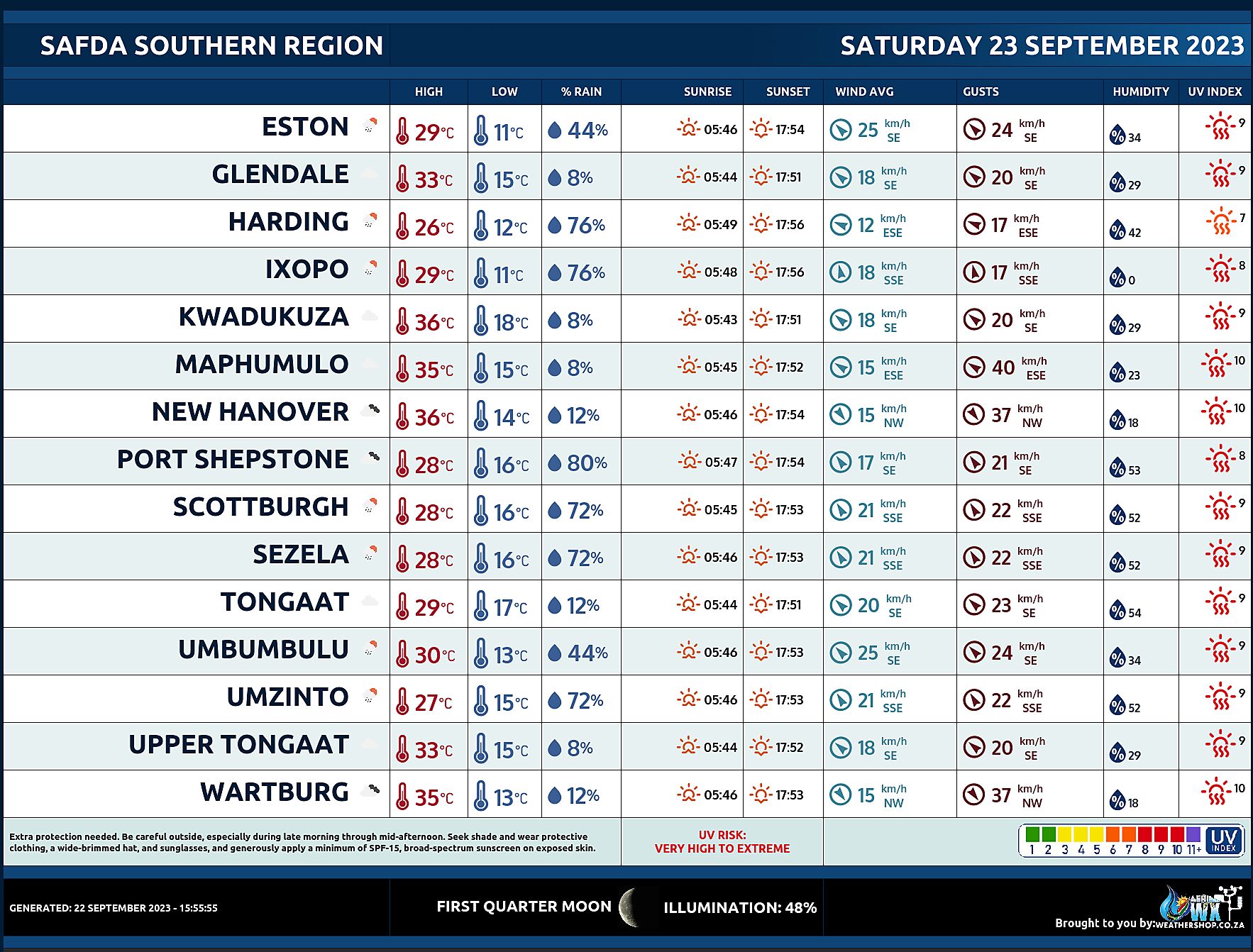
SAFDA Sugar Cane Farming (Southern Kwazulu-Natal) Weather Forecast Saturday 23 September 2023
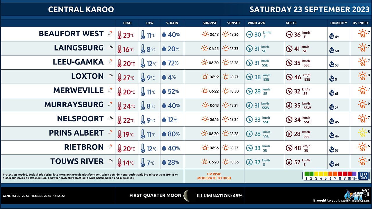
Central Karoo (Northern Cape) Farming Weather Forecast Saturday 23 September 2023
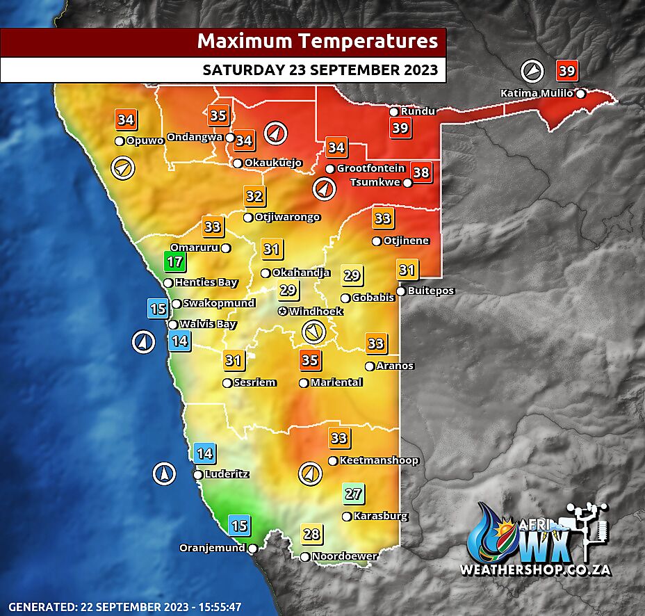
Namibia Maximum Temperatures Saturday 23 September 2023
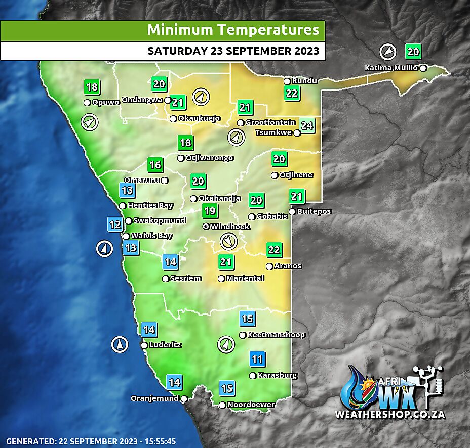
Namibia Minimum Temperatures Saturday 23 September 2023
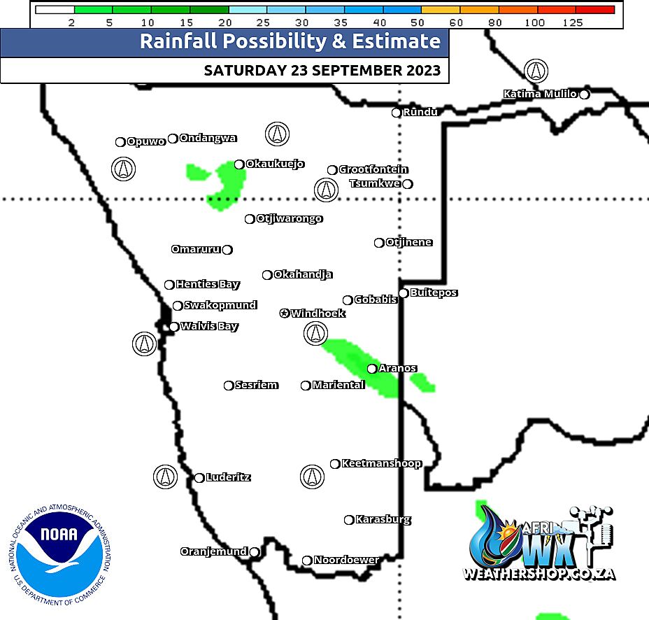
Namibia Rainfall Probability Map Saturday 23 September 2023
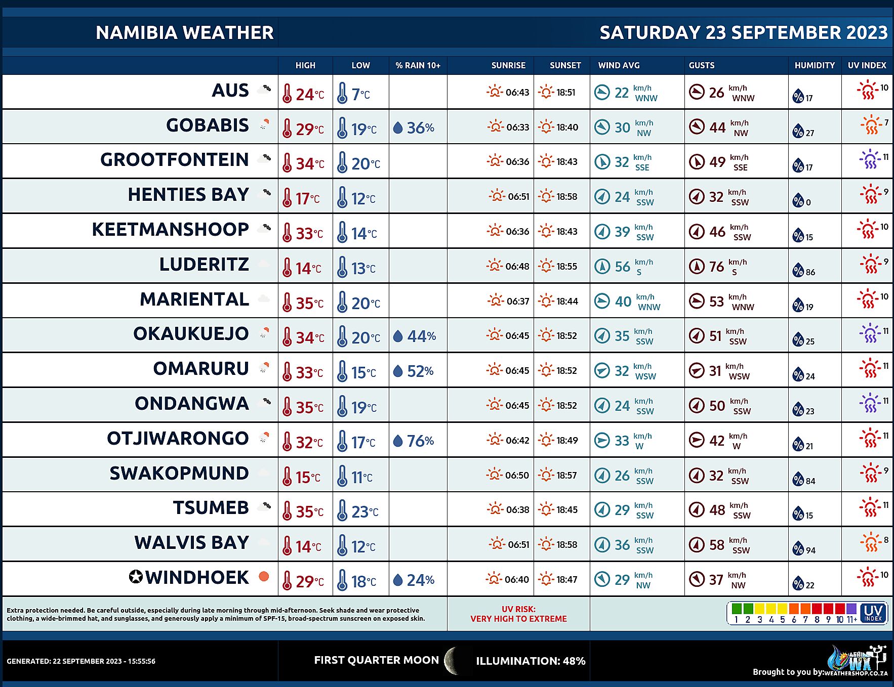
Namibia Weather Meteogram Saturday 23 September 2023
Namibia Meteorological Services METEONA Weather Forecast Saturday 23 September 2023
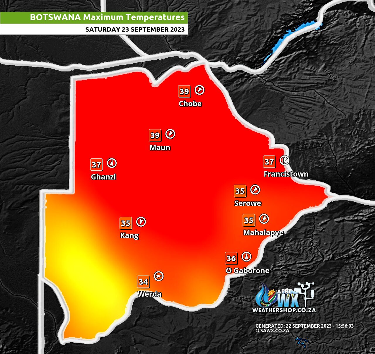
Botswana Maximum Temperatures Saturday 23 September 2023
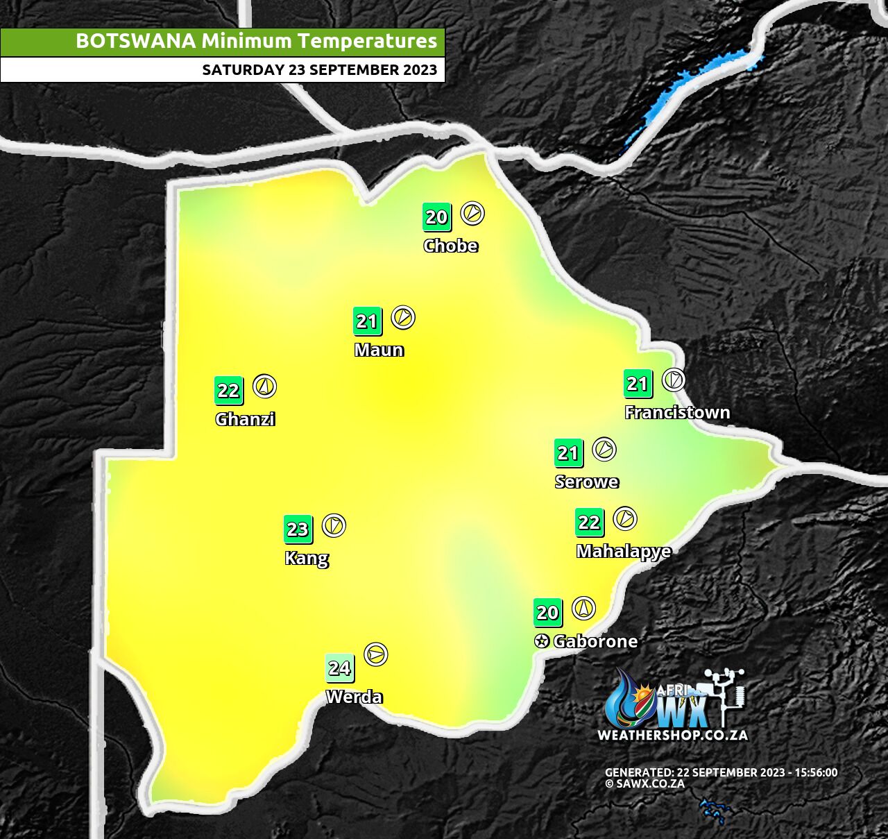
Botswana Minimum Temperatures Saturday 23 September 2023
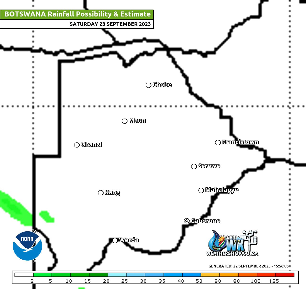
Botswana Rainfall Possibility Map Saturday 23 September 2023
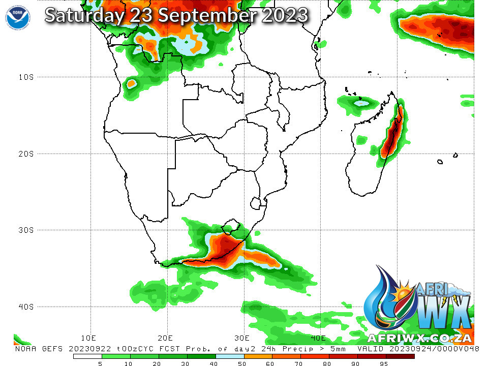
NOAA GEFS Global Ensemble Rainfall Outlook Southern Africa
JOIN OUR FREE AFRIWX WEATHER GROUP on Telegram Messenger
Please download Telegram for Android or iPhone if you want to always be up to date with the latest weather maps.
CLICK HERE TO JOIN our Telegram Group Now

