Last Updated on 27th December 2020 3:44 PM by AfriWX
THE REGIONAL WEATHER FORECAST
FOR TOMORROW 2020-07-10
ISSUED AT 1600 SAST
BY THE SOUTH AFRICAN WEATHER SERVICE.
SEVERE WEATHER ALERTS
WARNINGS
1.
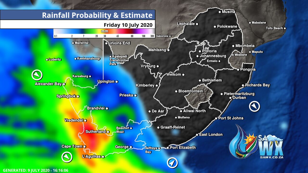
Heavy rain leading to flooding is expected over the western and south western parts of the Western Cape from the afternoon.
2.
Extremely high fire danger conditions are expected over the eastern interior of the Northern Cape, northern interior of the Eastern Cape and western parts of the North West as well as western and southern parts of the Free State Province.
3.
Disruptive snow expected over the western mountains of the Western Cape and south western high ground of the Northern Cape from the afternoon.
4.
High seas with wave heights from 6 to 8m are expected between Alexander Bay and Cape Point.
WATCHES
5.
Strong to gale force NW winds are expected in places over the interior of the Eastern Cape Province.
SPECIAL WEATHER ADVISORIES
Nil.
PROVINCIAL WEATHER OVERVIEW
GAUTENG PROVINCE
Partly cloudy and cool.
The expected UVB sunburn Index Low
MPUMALANGA PROVINCE
Morning fog patches over the Highveld, otherwise fine and cool, but warm in the Lowveld, becoming partly cloudy from the afternoon.
LIMPOPO PROVINCE
Private Bag X097, Pretoria, 0001 • Tel + 27 (0) 12 367 6000 • www.
weathersa.
co.
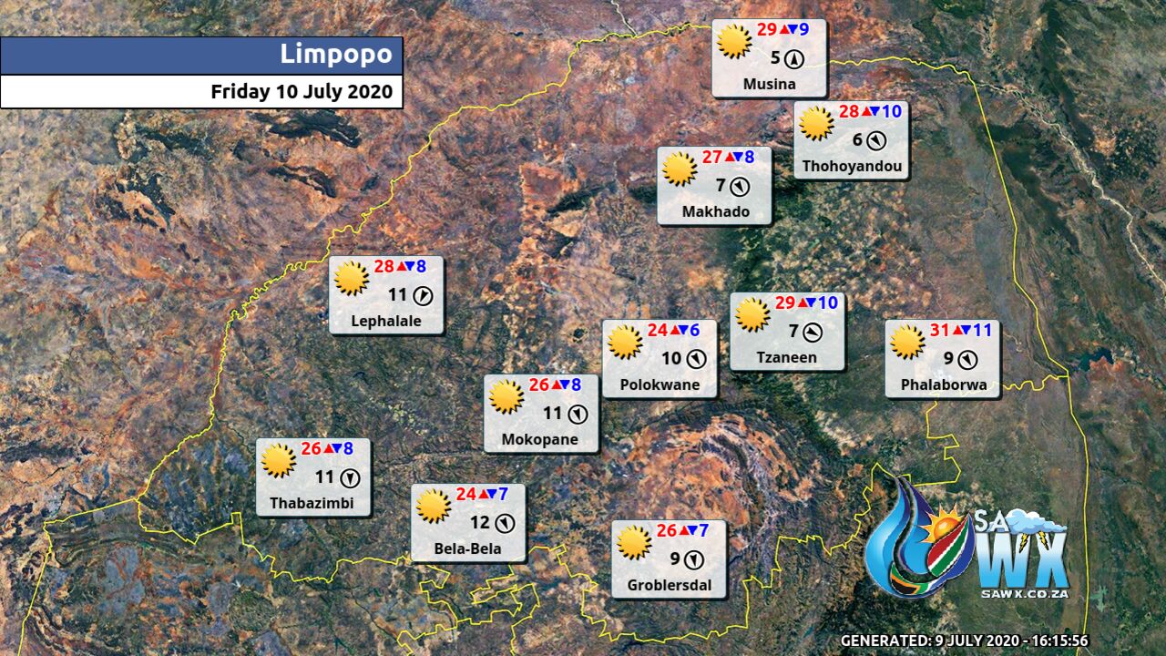
za • USSD *120*7297# Partly cloudy and warm.
NORTH-WEST PROVINCE
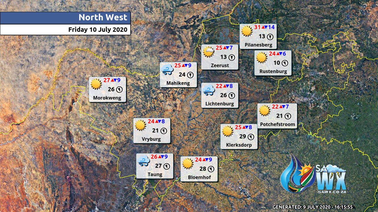
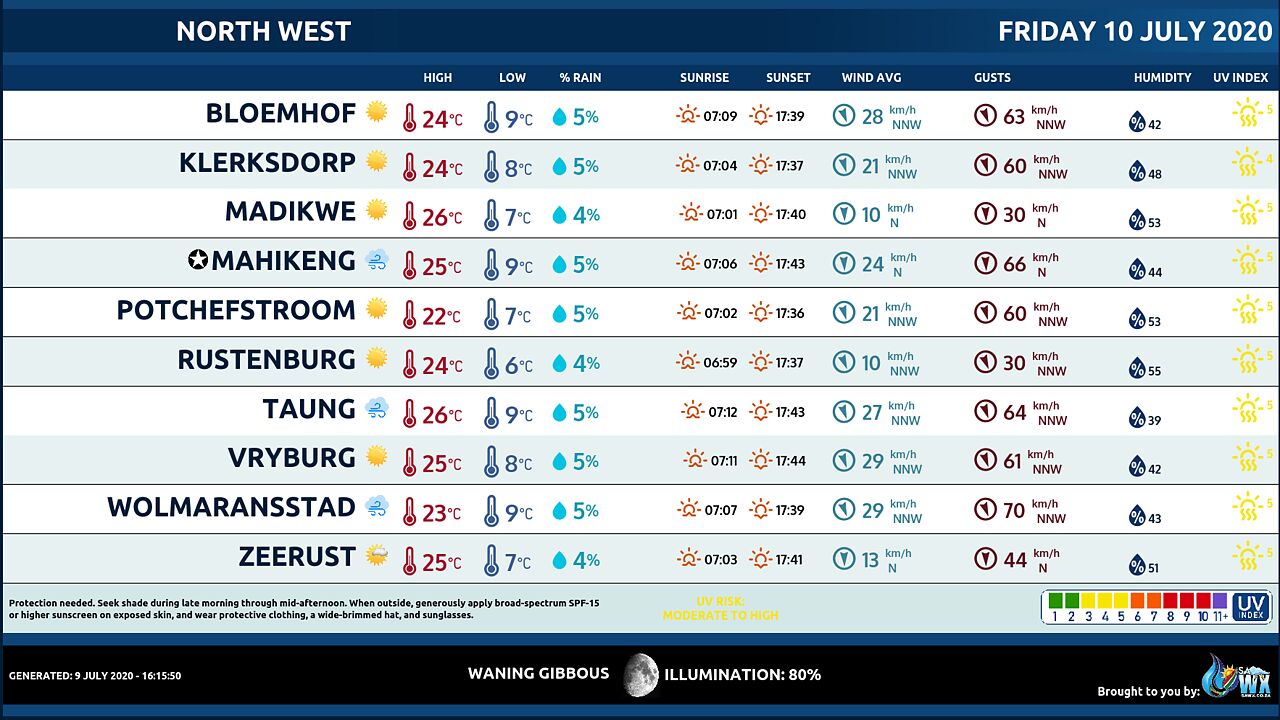
Partly cloudy in the east, otherwise fine and cool.
FREE STATE
Partly cloudy and cool.
NORTHERN CAPE
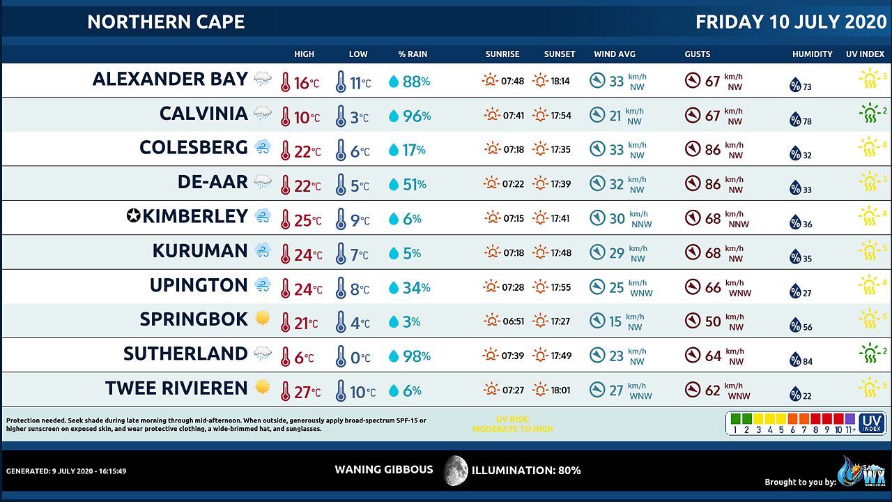
Fine in the north otherwise partly cloudy and cool but cloudy in the west and the south with isolated to scattered showers.
It will be very cold over the south western high ground with possible disruptive snowfalls on the mountain from the afternoon.
The wind along the coast will be strong to gale northerly to north-westerly.
WESTERN CAPE
Cloudy and cold with isolated to scattered showers and rain, but widespread in the south west where heavy rain and possible localized flooding will be expected.
Disruptive snow possible over the western mountains in the afternoon but light snowfalls in the eastern mountains by the evening.
The wind along the coast will be strong to gale force north-westerly but moderate to fresh northerly to north-easterly in the east.
The expected UVB sunburn Index Low
WESTERN HALF OF THE EASTERN CAPE
Cool in the southwest, otherwise partly cloudy and warm with strong winds over the interior, becoming cloudy FROM THE WEST with ISOLATED showers in the afternoon.
Light Snowfalls can be expected over the high mountains overnight.
The wind along the coast will be Light westerly early morning, otherwise light to moderate easterly.
EASTERN HALF OF THE EASTERN CAPE
Private Bag X097, Pretoria, 0001 • Tel + 27 (0) 12 367 6000 • www.
weathersa.
co.
za • USSD *120*7297# Partly cloudy and warm with strong winds in places over the interior.
The wind along the coast will be Light westerly, becoming moderate north easterly from mid-morning, but south westerly west of East London in the evening.
KWAZULU-NATAL
Fine and warm, but cool in the west.
The wind along the coast will be Moderate to Fresh north-easterly.
The expected UVB sunburn Index Moderate
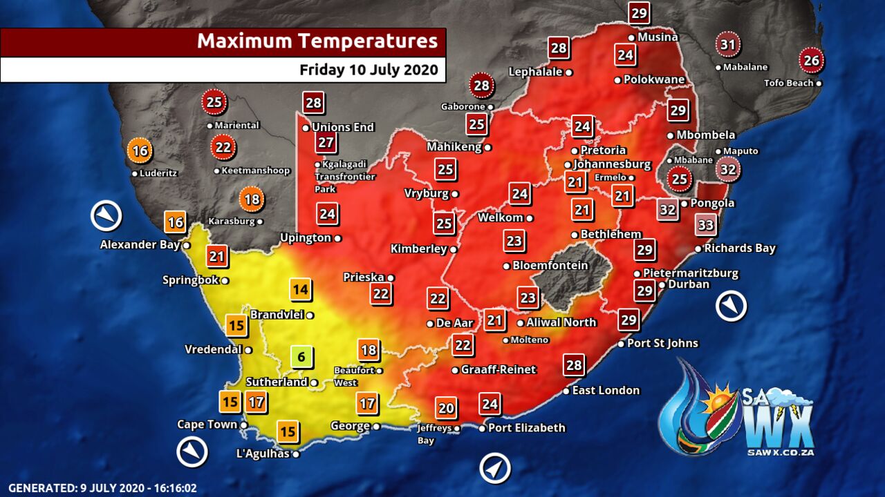
Maximum Temperatures Forecast for South Africa Friday 10 July 2020
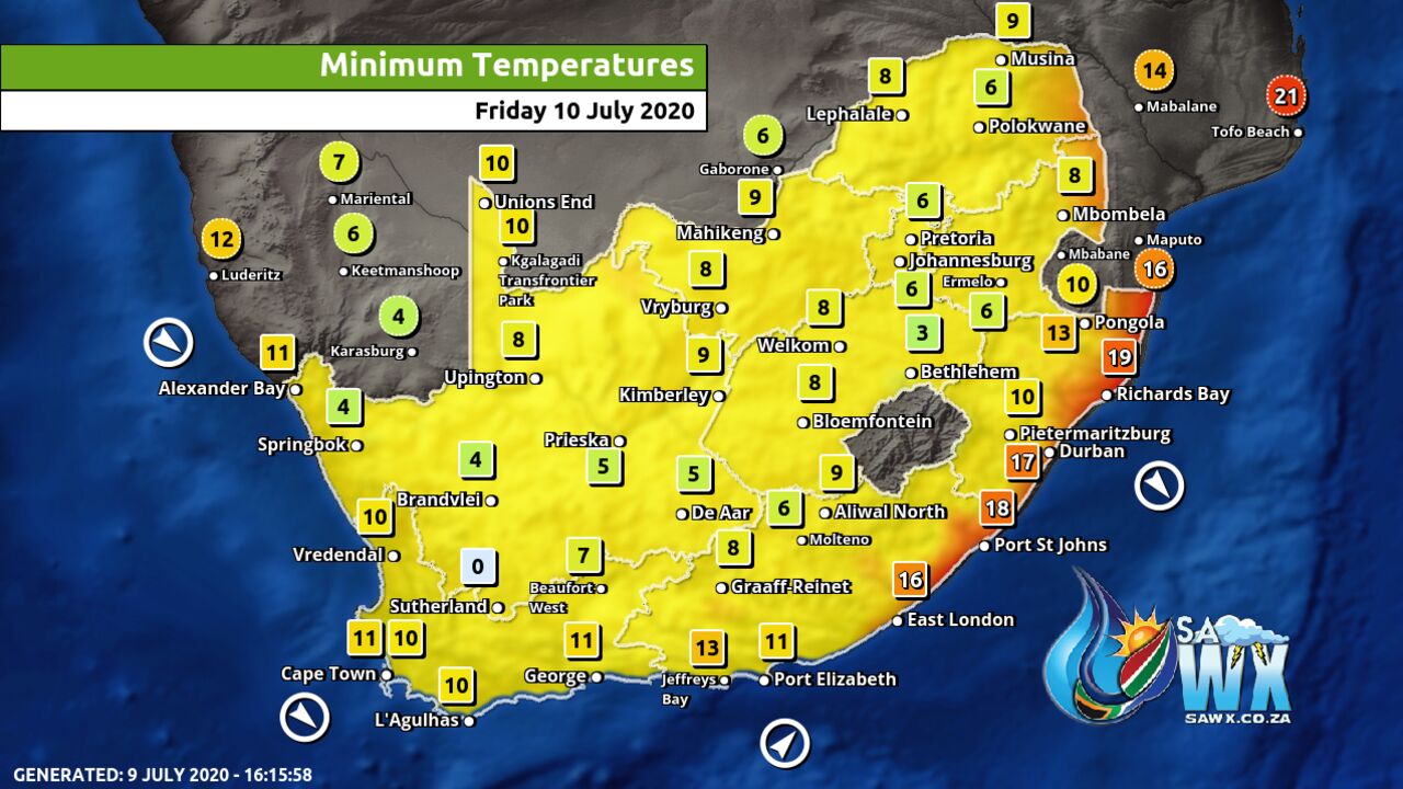
Minimum Temperatures Forecast for South Africa Friday 10 July 2020
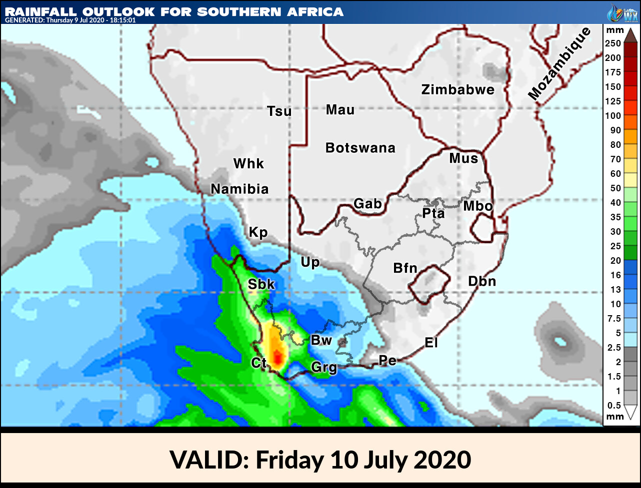
Rainfall Outlook for South Africa Friday 10 July 2020
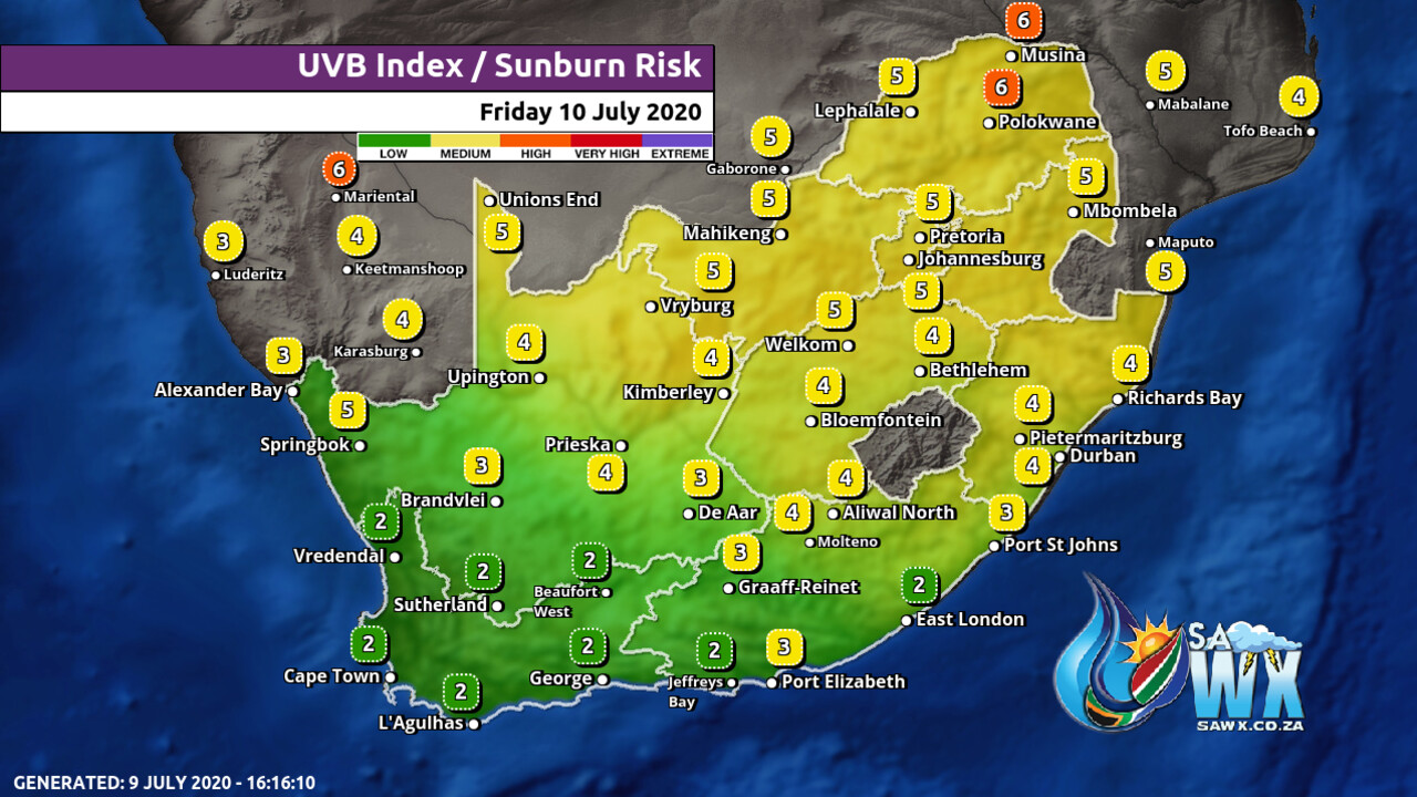
UVB Index Outlook for South Africa Friday 10 July 2020
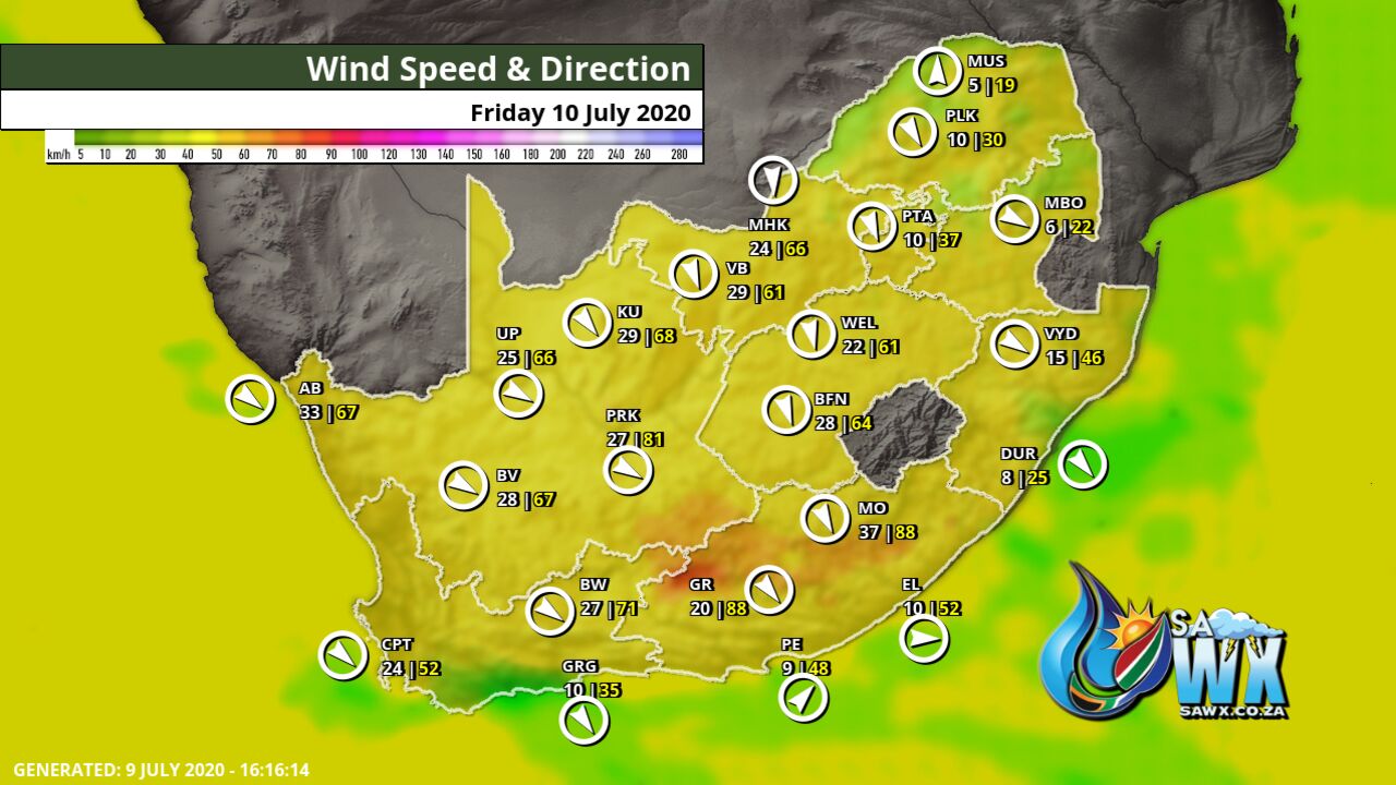
Wind Speed Direction and Gusts Map for South Africa Friday 10 July 2020
TRAVELLERS WEATHER FORECAST
FOR TOMORROW 2020-07-10
ISSUED AT 1600 SAST
BY THE SOUTH AFRICAN WEATHER SERVICE.
SEVERE WEATHER ALERTS
WARNINGS
1.
Heavy rain leading to flooding is expected over the western and south western parts of the Western Cape from the afternoon.
2.
Extremely high fire danger conditions are expected over the eastern interior of the Northern Cape, northern interior of the Eastern Cape and western parts of the North West as well as western and southern parts of the Free State Province.
3.
Disruptive snow expected over the western mountains of the Western Cape and south western high ground of the Northern Cape from the afternoon.
4.
High seas with wave heights from 6 to 8m are expected between Alexander Bay and Cape Point.
WATCHES
5.
Strong to gale force NW winds are expected in places over the interior of the Eastern Cape Province.
SPECIAL WEATHER ADVISORIES
Nil.
WEATHER IN OUR TOP CITIES
PRETORIA
Partly cloudy.
Minimum/Maximum 6/22 The expected UVB Sunburn Index Low
JOHANNESBURG
Partly cloudy.
Minimum/Maximum 5/21
VEREENIGING
Private Bag X097, Pretoria, 0001 • Tel + 27 (0) 12 367 6000 • www.
weathersa.
co.
za • USSD *120*7297# – Partly cloudy.
Minimum/Maximum 2/20
MBOMBELA
Fine, becoming partly cloudy in the afternoon.
Minimum/Maximum 8/24
POLOKWANE
– Partly cloudy.
Minimum/Maximum 6/23
MAHIKENG
Fine and windy.
Minimum/Maximum 6/25
VRYBURG
Fine and windy.
Minimum/Maximum 5/24
BLOEMFONTEIN
Fine and windy.
Minimum/Maximum 6/22
KIMBERLEY
– Fine and windy.
Minimum/Maximum 9/23
UPINGTON
Fine.
Minimum/Maximum 11/23
CAPE TOWN
– Cloudy with widespread showers and rain with possible heavy rain leading to localized flooding.
Wind Fresh northerly to north-westerly becoming strong in the afternoon Minimum/Maximum 12/14 Private Bag X097, Pretoria, 0001 • Tel + 27 (0) 12 367 6000 • www.
weathersa.
co.
za • USSD *120*7297# The expected UVB Sunburn Index Low
GEORGE
Cloudy with isolated showers from the afternoon.
Wind Light to moderate northerly becoming fresh north-westerly by the evening.
Minimum/Maximum 10/15
PORT ELIZABETH
– Partly cloudy, becoming cloudy with isolated evening showers.
Wind Light north westerly, becoming light south easterly at times during the afternoon.
Minimum/Maximum 9/21
EAST LONDON
– Partly cloudy.
Wind Light and variable, becoming light southeasterly late morning, but light south westerly in the evening.
Minimum/Maximum 16/25
DURBAN
Fine.
Wind Moderate easterly to north-easterly.
Minimum/Maximum 15/26 The expected UVB Sunburn Index Moderate
RICHARDS BAY
Fine.
Wind Moderate to fresh north-easterly.
Minimum/Maximum 15/28
PIETERMARITZBURG
Fine.
Minimum/Maximum 10/26
Rainfall Outlook for Tomorrow Friday 10 July 2020
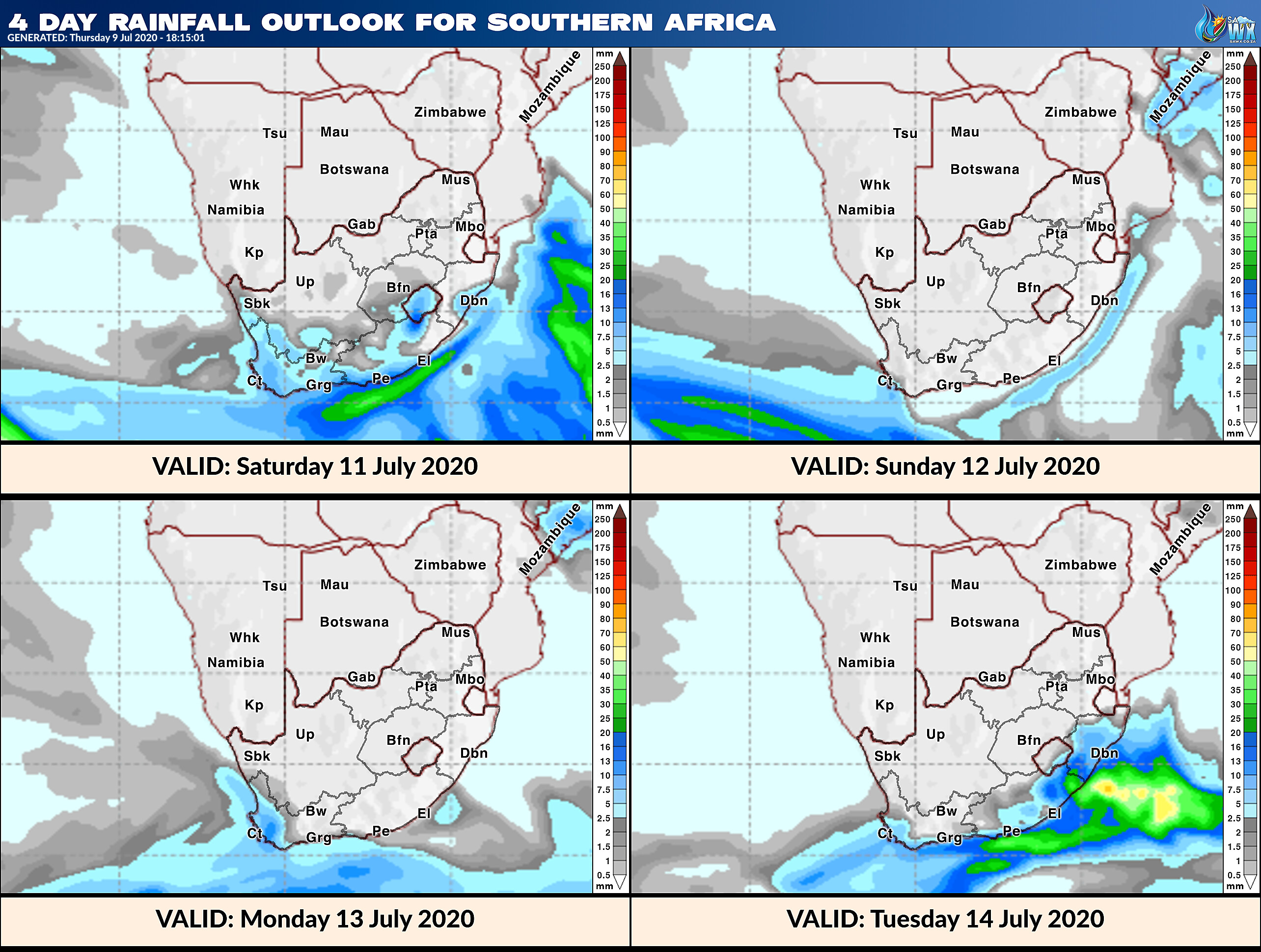
4 Day Rainfall Outlook for Southern Africa
14 Day Rainfall Outlook for Southern Africa
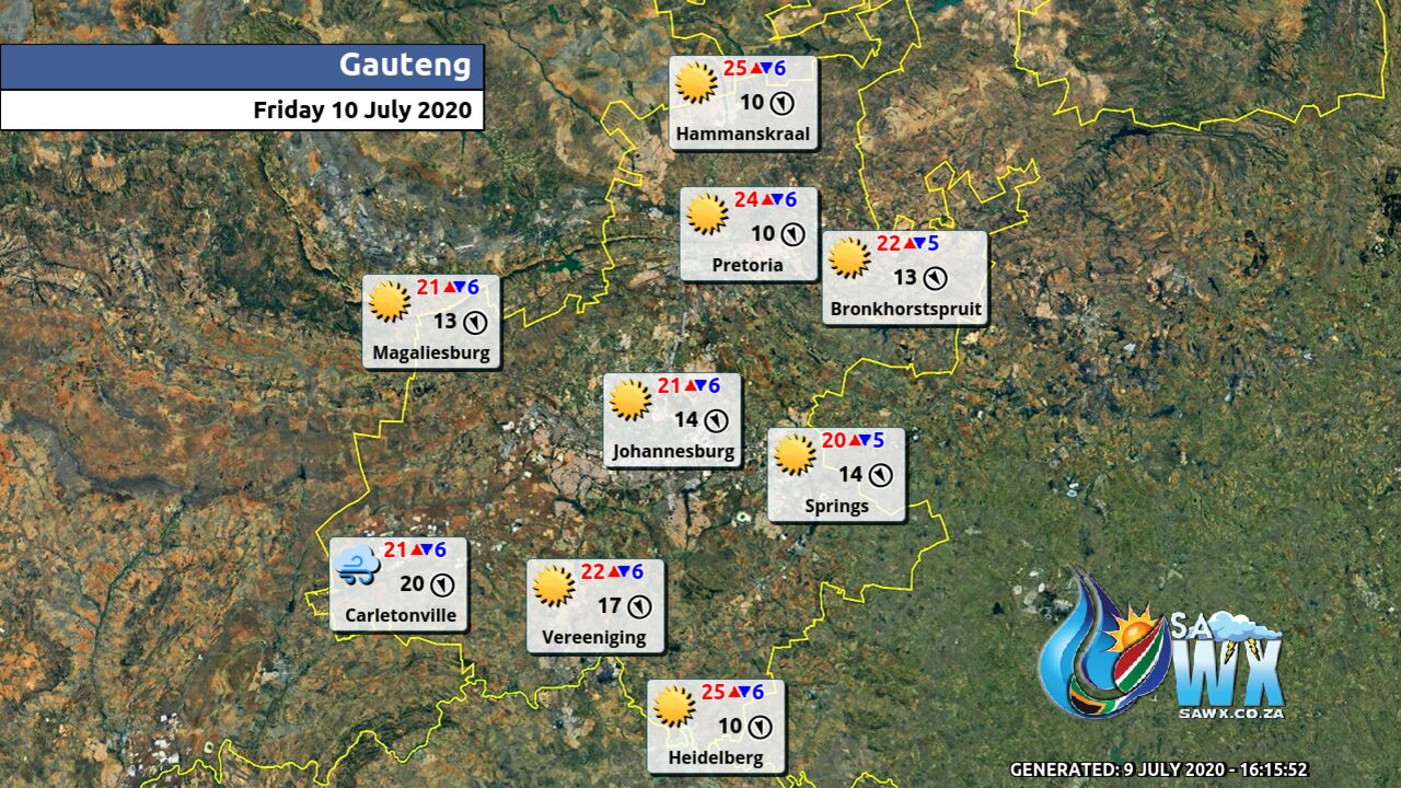
Gauteng Province Weather Map Friday 10 July 2020
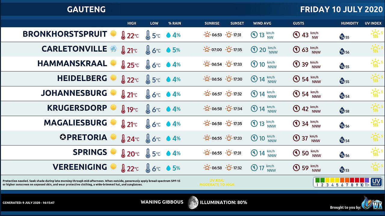
Gauteng Province Weather Meteogram Friday 10 July 2020
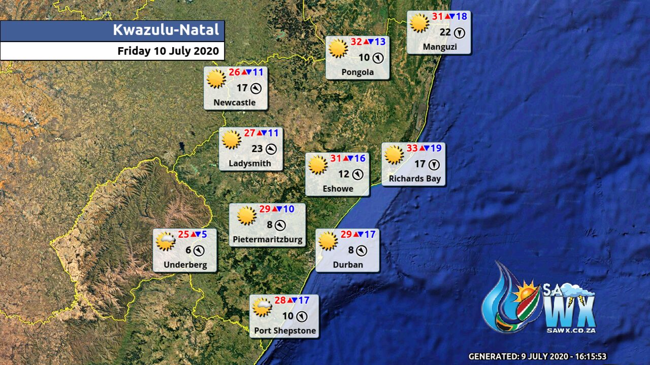
Kwazulu-Natal Province Weather Map Friday 10 July 2020
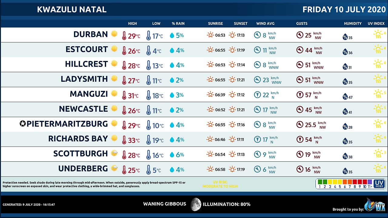
Kwazulu-Natal Province Weather Meteogram Friday 10 July 2020
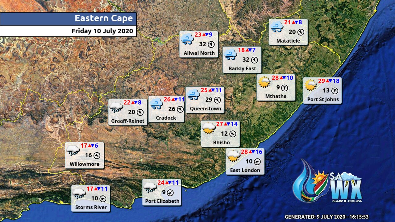
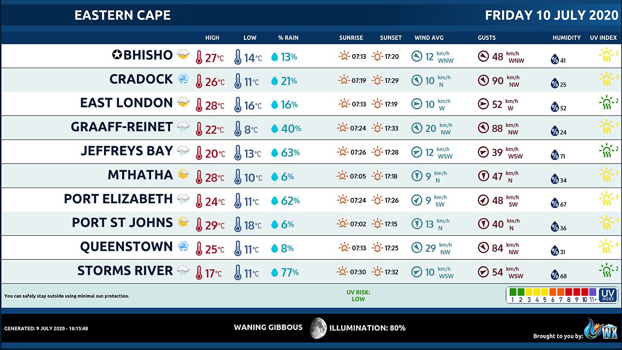
Eastern Cape Province Weather Map Friday 10 July 2020
Eastern Cape Province Weather Meteogram Friday 10 July 2020
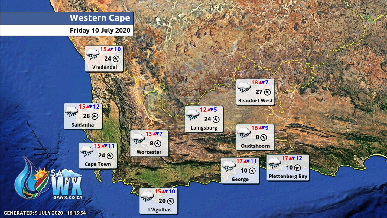
Western Cape Province Weather Map Friday 10 July 2020
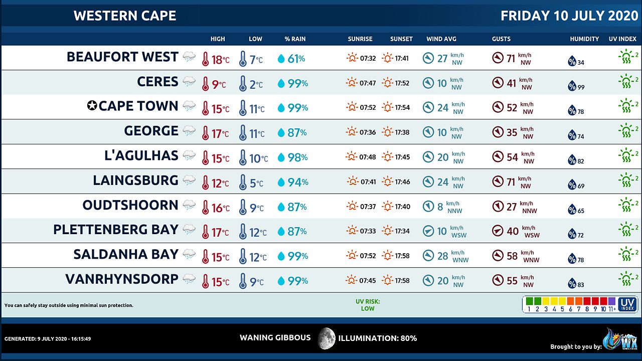
Western Cape Province Weather Meteogram Friday 10 July 2020
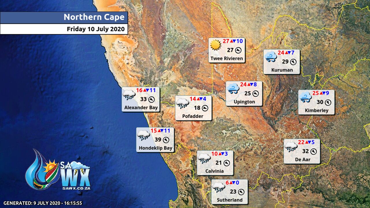
Northern Cape Province Weather Map Friday 10 July 2020
Northern Cape Province Weather Meteogram Friday 10 July 2020
North-West Province Weather Map Friday 10 July 2020
North-West Province Weather Meteogram Friday 10 July 2020
Limpopo Province Weather Map Friday 10 July 2020
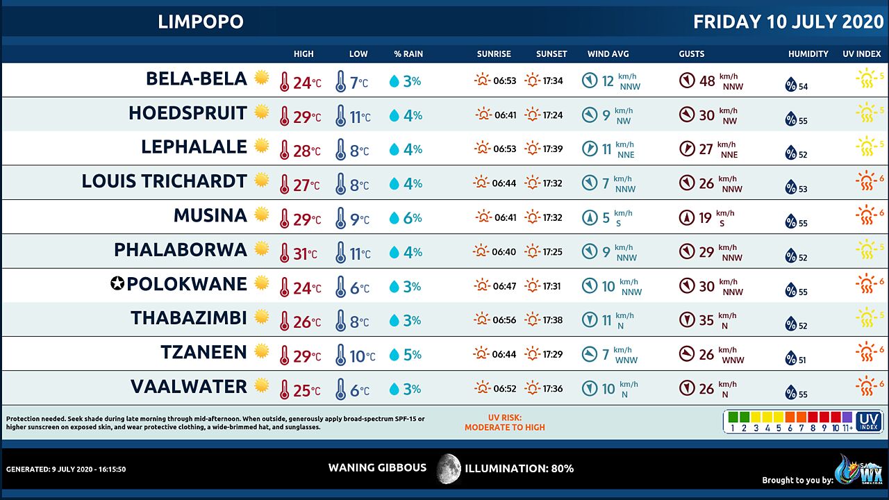
Limpopo Province Weather Meteogram Friday 10 July 2020
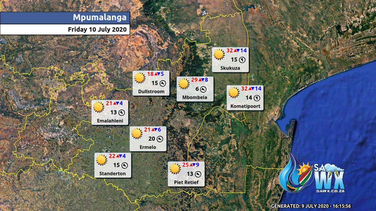
Mpumalanga Province Weather Map Friday 10 July 2020
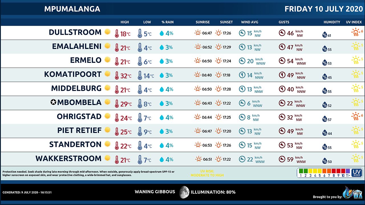
Mpumalanga Province Weather Meteogram Friday 10 July 2020
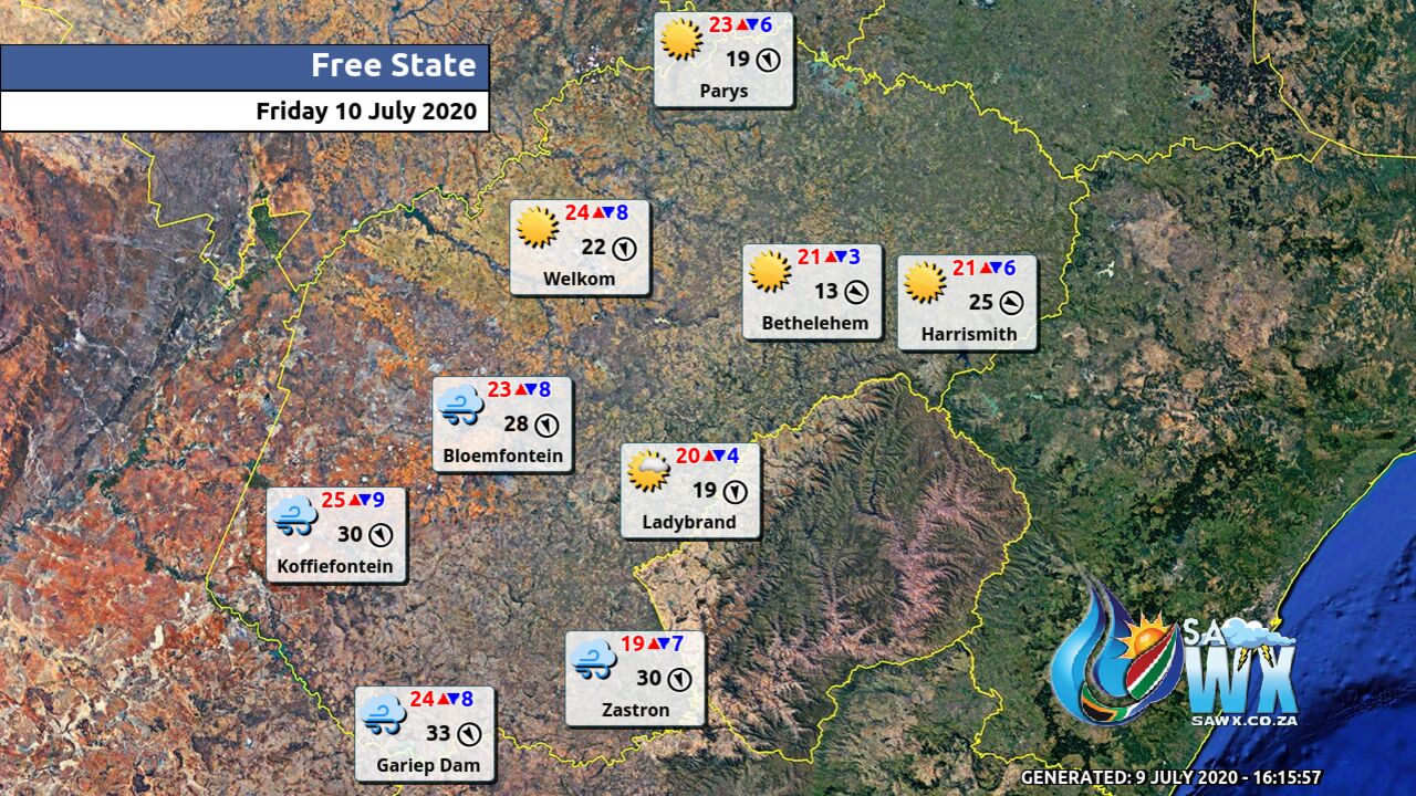
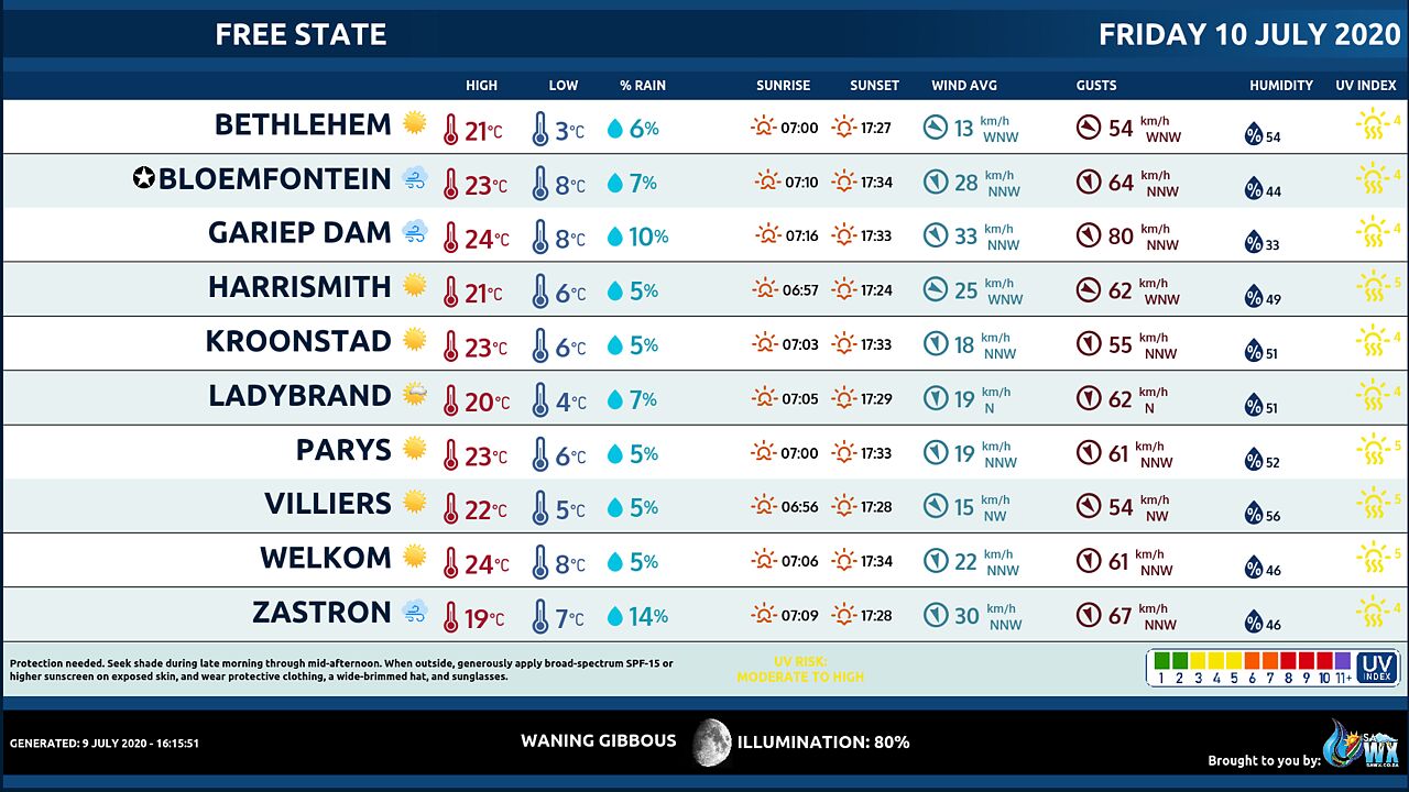
Free State Province Weather Map Friday 10 July 2020
Free State Province Weather Meteogram Friday 10 July 2020
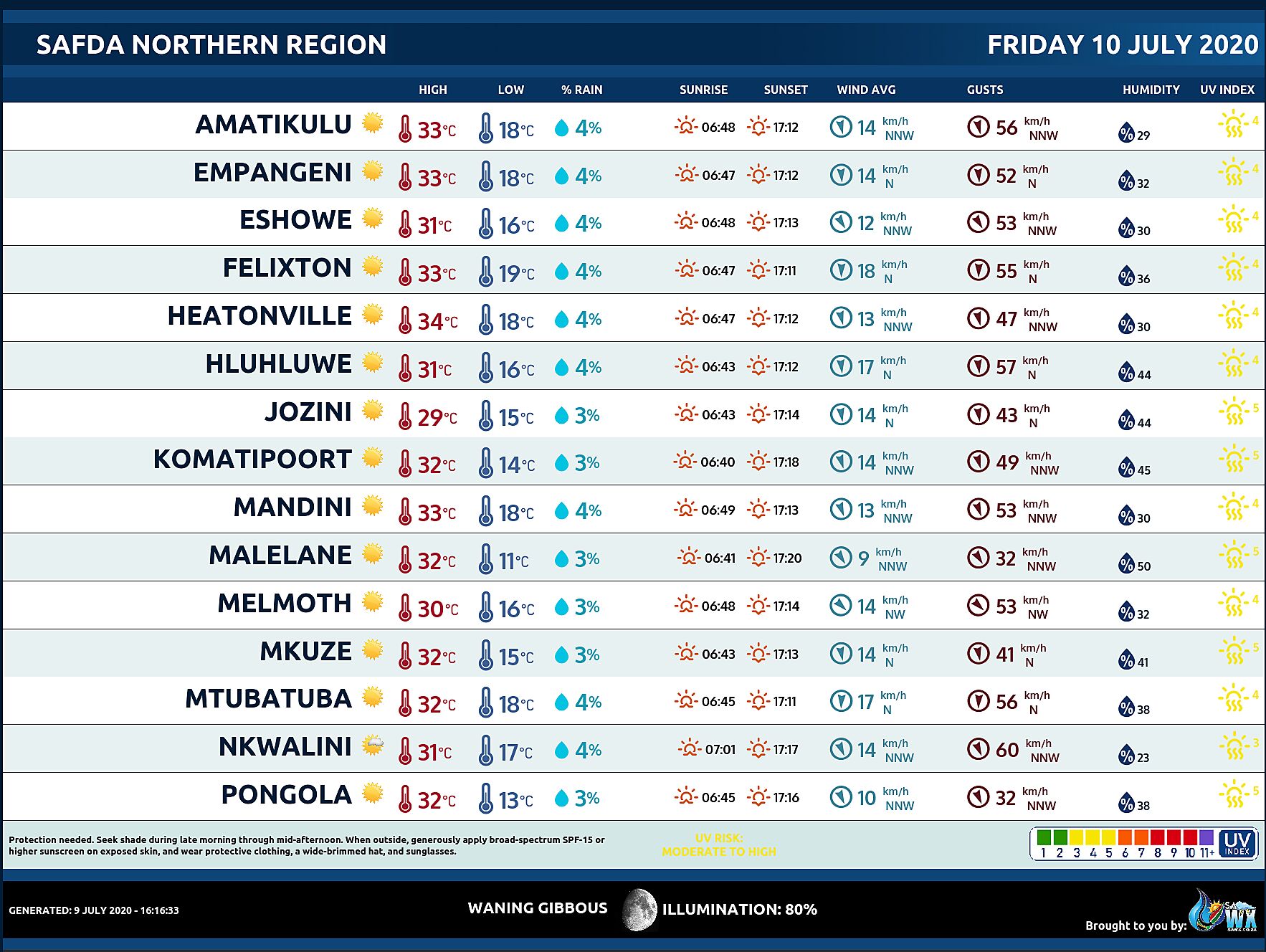
SAFDA Sugar Cane Farming (Northern Kwazulu-Natal) Weather Forecast Friday 10 July 2020
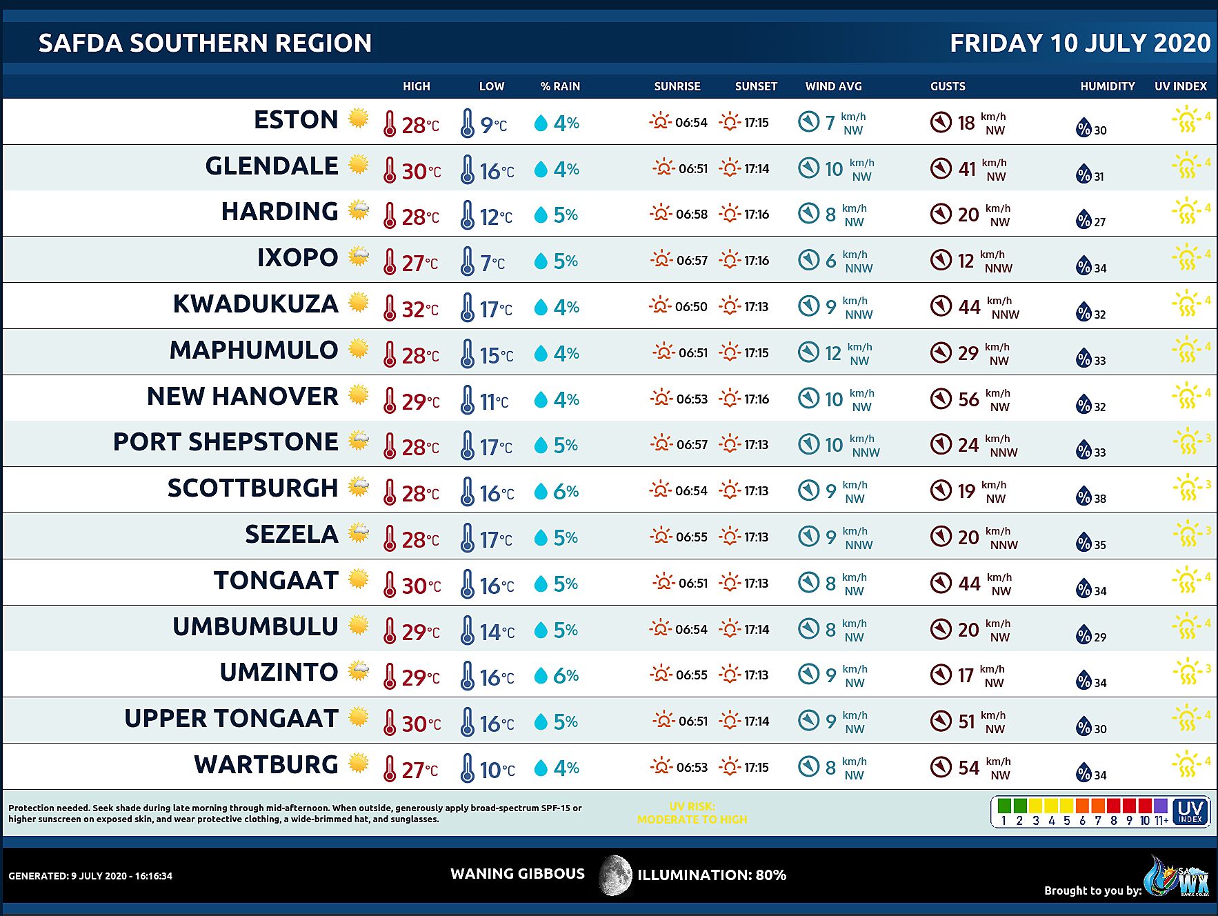
SAFDA Sugar Cane Farming (Southern Kwazulu-Natal) Weather Forecast Friday 10 July 2020
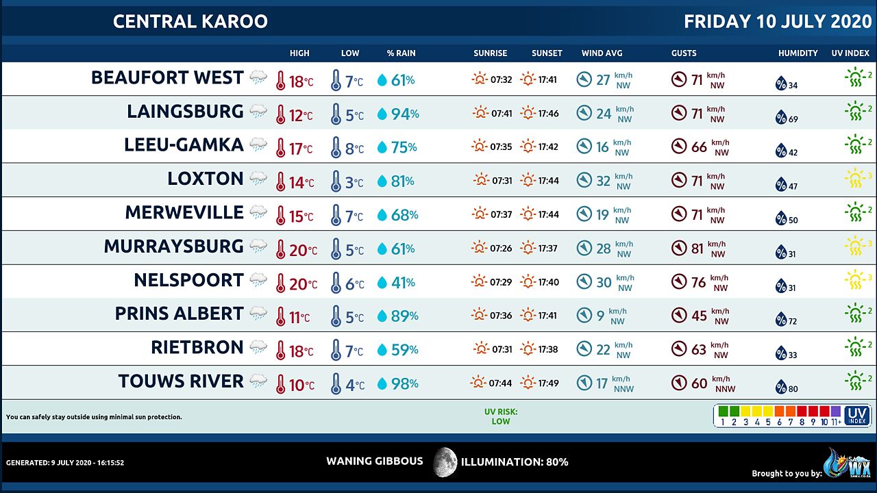
Central Karoo (Northern Cape) Farming Weather Forecast Friday 10 July 2020
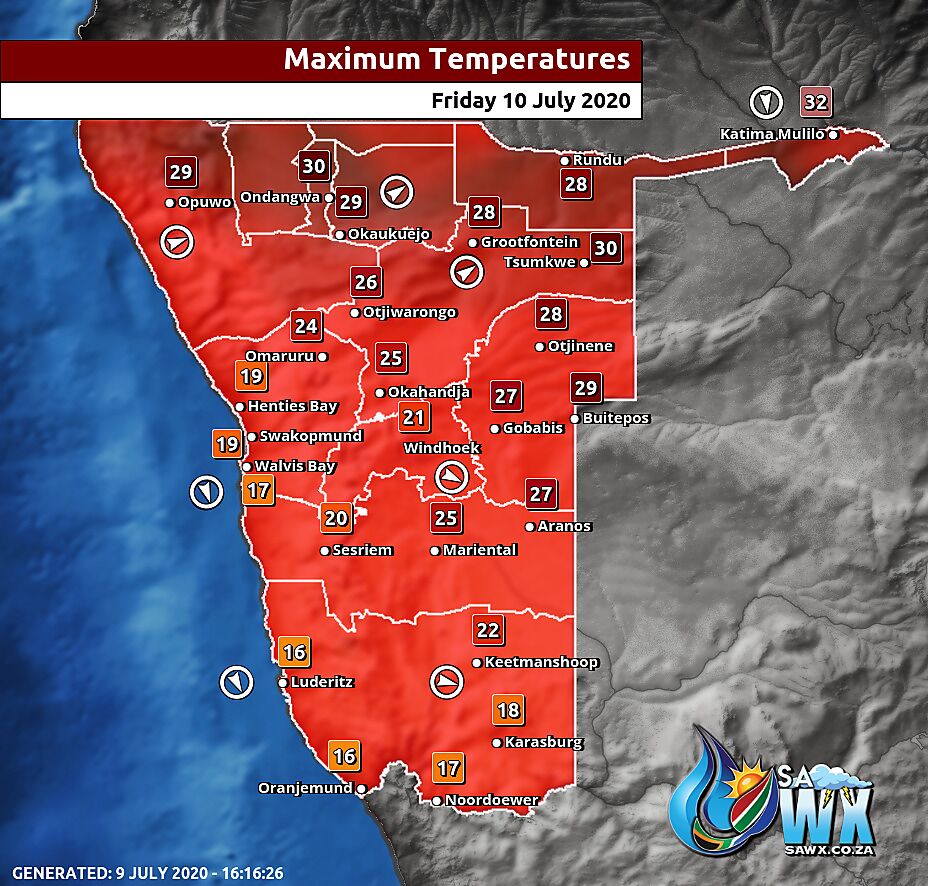
Namibia Maximum Temperatures Friday 10 July 2020
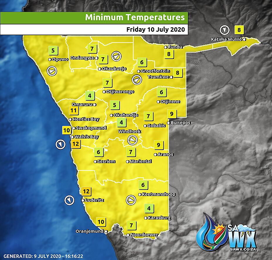
Namibia Minimum Temperatures Friday 10 July 2020
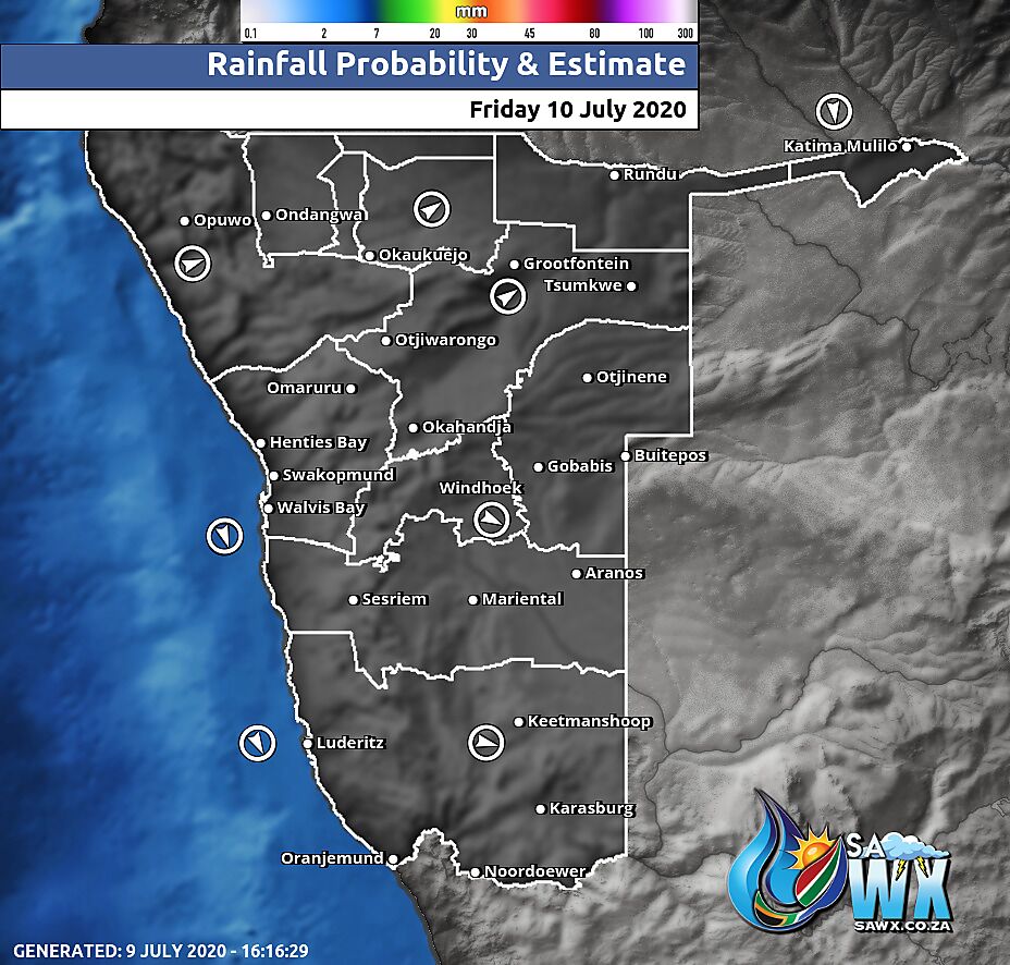
Namibia Rainfall Probability Map Friday 10 July 2020
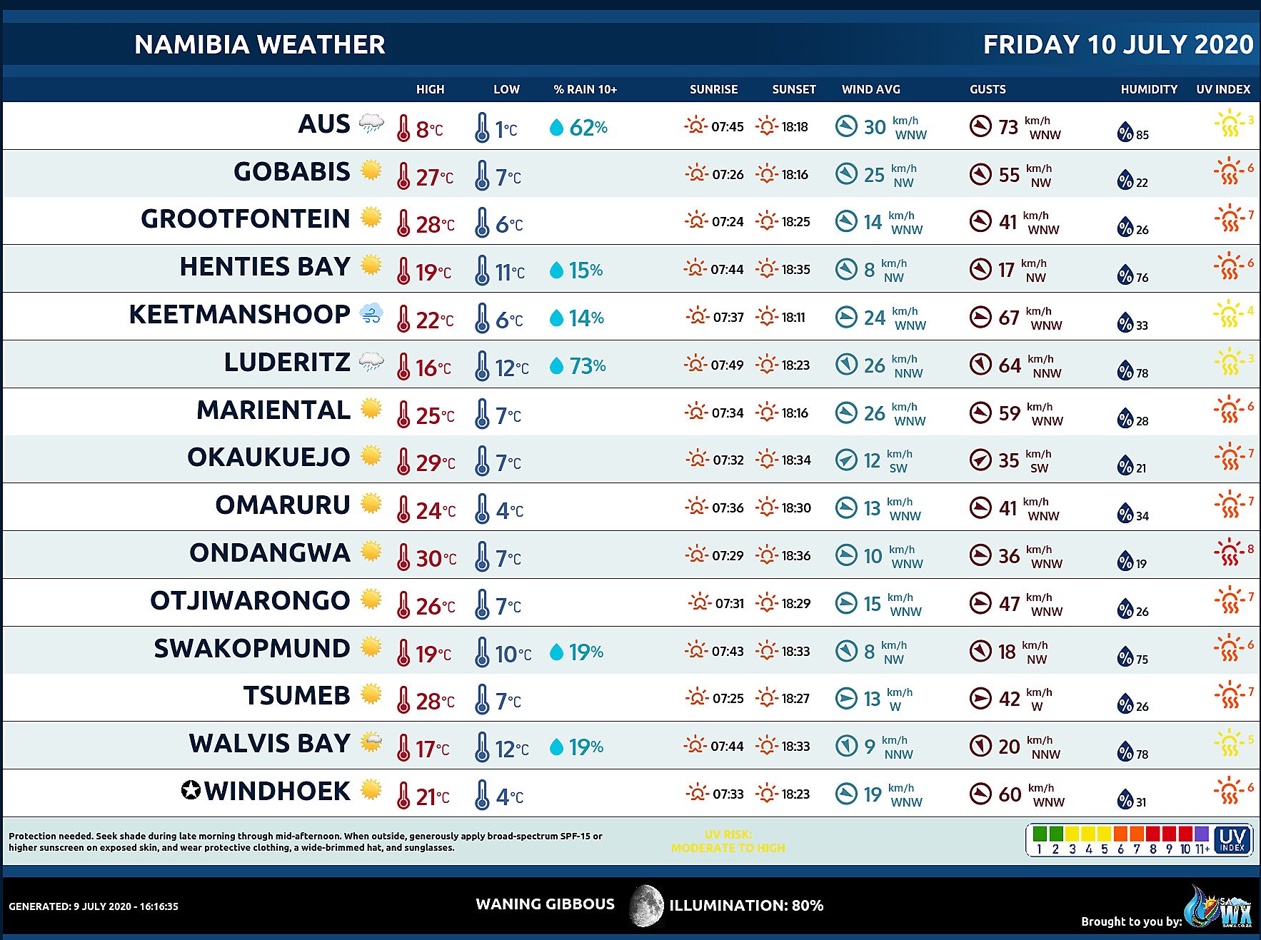
Namibia Weather Meteogram Friday 10 July 2020
Namibia Meteorological Services METEONA Weather Forecast Friday 10 July 2020
Weather Maps by SAWX – Feel Free to Share

