Last Updated on 27th October 2023 6:45 PM by AfriWX
THE REGIONAL WEATHER FORECAST
FOR TOMORROW 2023-10-28
ISSUED AT 1600 SAST
BY THE SOUTH AFRICAN WEATHER SERVICE. THIS FORECAST WILL BE UPDATED AT 0500 SAST.
SEVERE WEATHER ALERTS
IMPACT-BASED
WARNINGS
A. A yellow level 4 warning for disruptive rain leading to flooding of settlements, roads and bridges as well as disruption to livelihoods is expected over parts of the Wild Coast and adjacent interior of the Eastern Cape. B. A yellow level 2 warning for severe thunderstorms leading to gusty winds, heavy downpours and large amounts of small hail is expected over most parts of KwaZulu-Natal and the south-eastern parts of Mpumalanga, as well as the south-eastern parts of the North West and the eastern parts of the Free State. C. A yellow level 2 warning for damaging waves leading to temporary disruptions of beachfront activities and difficulty in navigation at sea is expected between Cape Columbine and Plettenberg Bay. D. A yellow level 2 warning for winds leading to difficulty in navigation at sea is expected between Alexander Bay and Cape Agulhas. FIRE DANGER
WARNINGS
– Nil. ADVISORIES
1. An intense cut-off low pressure system is expected to affect the southern, central and eastern parts of the country from Sunday until Wednesday (29 October to 01 November). The public and small stock farmers are advised that cold to very cold, wet and windy conditions are expected over the Eastern Cape from Saturday spreading to KwaZulu-Natal, Free State, Mpumalanga, Gauteng, Limpopo and North West from Sunday into Monday. Snow can be expected on the high ground of the Eastern Cape, KwaZulu-Natal, eastern Free State and extreme southern highveld of Mpumalanga with disruptive snowfall possible over the northern high ground of the Eastern Cape and western high ground and Drakensberg region of KwaZulu-Natal from Sunday.
PROVINCIAL WEATHER OVERVIEW
GAUTENG PROVINCE
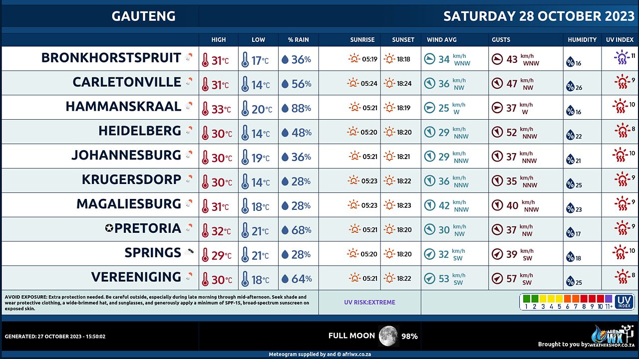
Partly cloudy and hot with isolated thundershowers from the afternoon but scattered in the south. The expected UVB sunburn Index High
MPUMALANGA PROVINCE
Partly cloudy and warm with isolated showers and thundershowers but scattered over the southern highveld.
LIMPOPO PROVINCE
Partly cloudy and hot to very with isolated showers and thundershowers in the west and south.
NORTH-WEST PROVINCE
Partly cloudy, windy and hot, with isolated thundershowers but scattered in the south-east.
FREE STATE
Partly cloudy, windy and warm to hot with isolated thundershowers but scattered in the east.
NORTHERN CAPE
Partly cloudy in the south and west in the morning, otherwise fine and warm but cool to cold in the south. It will be windy in places over the interior and along the coast. The wind along the coast will be strong southerly to south-easterly.
WESTERN CAPE
Partly cloudy and cool to cold but fine and warm over the west coast. It will be cloudy along the south coast and eastern interior with isolated to scattered showers and rain but widespread along the eastern parts of the south coast. The wind along the coast will be fresh to strong south-easterly but moderate to fresh southerly to south-westerly along the south coast in the morning. The expected UVB sunburn Index High
WESTERN HALF OF THE EASTERN CAPE
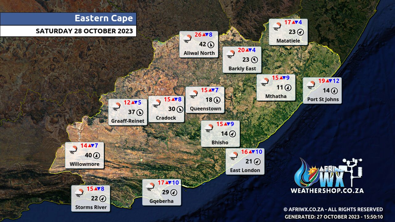
Cloudy and cool to cold with scattered showers and thundershowers but widespread in the south. Light snowfalls are expected over the high ground at night. The wind along the coast will be moderate to fresh south-westerly, becoming southerly from late afternoon.
EASTERN HALF OF THE EASTERN CAPE
Cloudy and cold with scattered showers and thundershowers but widespread along the coast and adjacent interior and isolated in the extreme north. Light snowfalls are expected over the northern mountains at night. The wind along the coast will be moderate to fresh south-westerly.
KWAZULU-NATAL
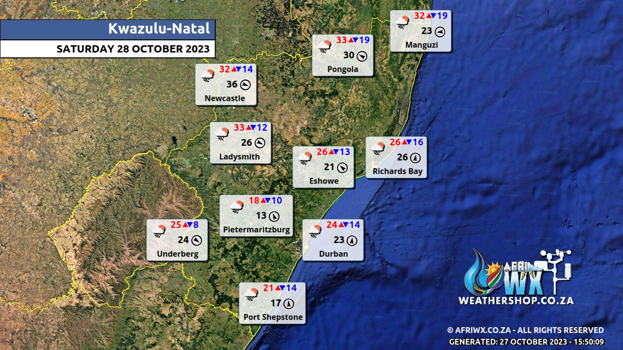
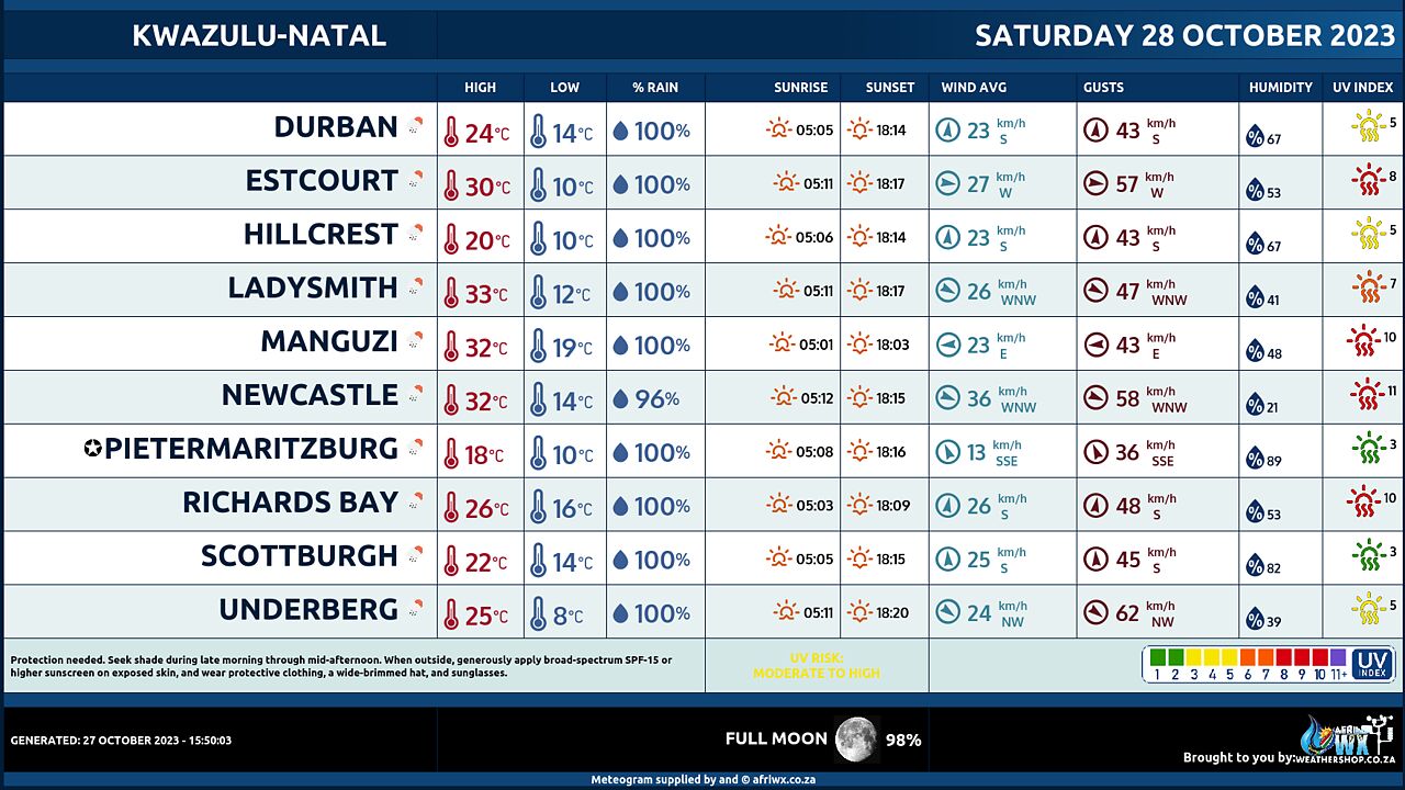
– Cloudy and cool to cold with widespread showers and thundershowers but scattered in the extreme north. The wind along the coast will be moderate to fresh south-westerly to southerly. The expected UVB sunburn Index Low
JOIN OUR FREE AFRIWX WEATHER GROUP on Telegram Messenger
Please download Telegram for Android or iPhone if you want to always be up to date with the latest weather maps.
CLICK HERE TO JOIN our Telegram Group Now
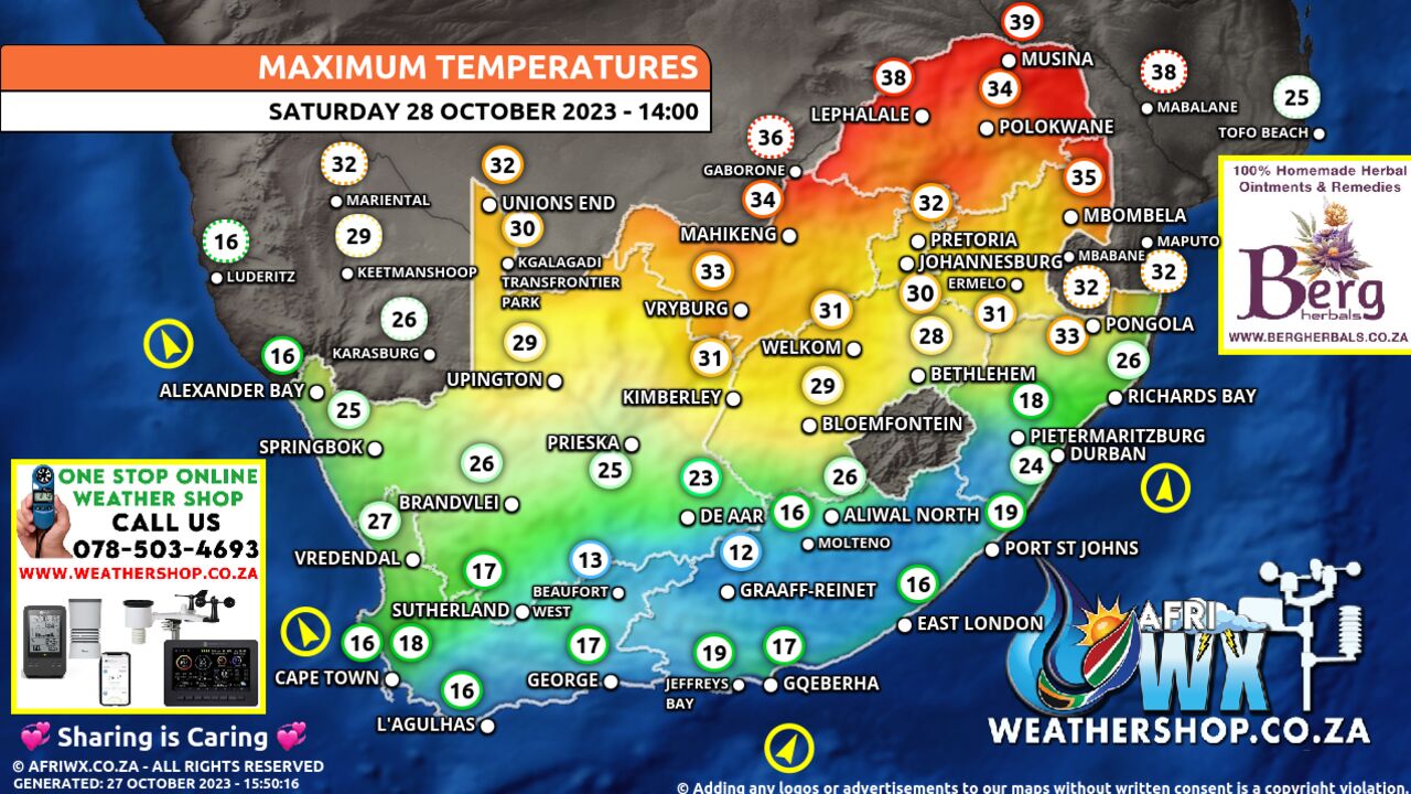
Maximum Temperatures Forecast for South Africa Saturday 28 October 2023
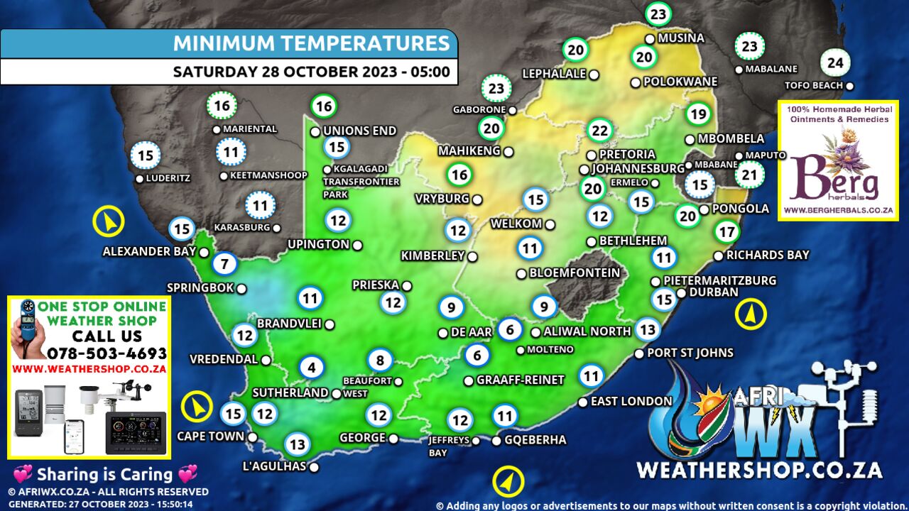
Minimum Temperatures Forecast for South Africa Saturday 28 October 2023
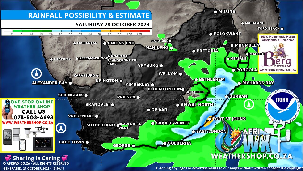
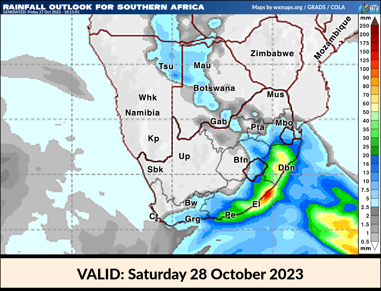
Rainfall Outlook for South Africa Saturday 28 October 2023
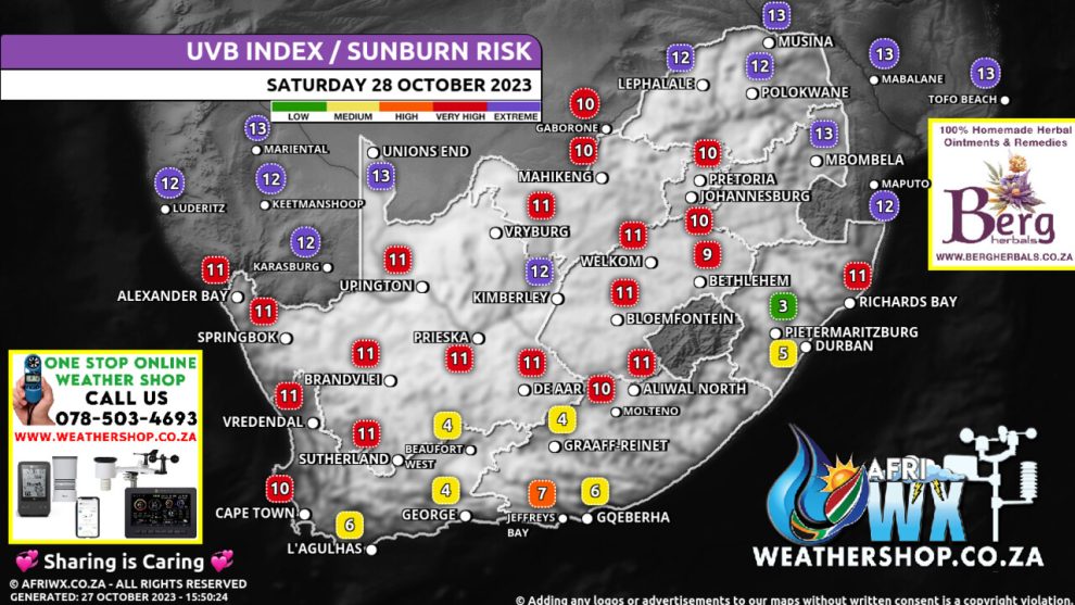
UVB Index Outlook for South Africa Saturday 28 October 2023
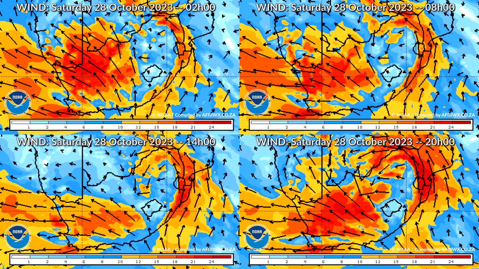
Wind Speed Direction and Gusts Map for South Africa Saturday 28 October 2023
TRAVELLERS WEATHER FORECAST
FOR TOMORROW 2023-10-28
ISSUED AT 1530 SAST
BY THE SOUTH AFRICAN WEATHER SERVICE.
SEVERE WEATHER ALERTS
IMPACT-BASED
WARNINGS
A.
A yellow level 4 warning for disruptive rain leading to flooding of settlements, roads and bridges as well as disruption to livelihoods is expected over parts of the Wild Coast and adjacent interior of the Eastern Cape.
B.
A yellow level 2 warning for severe thunderstorms leading to gusty winds, heavy downpours and large amounts of small hail is expected over most parts of KwaZulu-Natal and the south-eastern parts of Mpumalanga, as well as the south-eastern parts of the North West and the eastern parts of the Free State.
C.
A yellow level 2 warning for damaging waves leading to temporary disruptions of beachfront activities and difficulty in navigation at sea is expected between Cape Columbine and Plettenberg Bay.
D.
A yellow level 2 warning for winds leading to difficulty in navigation at sea is expected between Alexander Bay and Cape Agulhas.
FIRE DANGER
WARNINGS
Nil.
ADVISORIES – 1.
An intense cut-off low pressure system is expected to affect the southern, central and eastern parts of the country from Sunday until Wednesday (29 October to 01 November).
The public and small stock farmers are advised that cold to very cold, wet and windy conditions are expected over the Eastern Cape from Saturday spreading to KwaZulu-Natal, Free State, Mpumalanga, Gauteng, Limpopo and North West from Sunday into Monday.
Snow can be expected on the high ground of the Eastern Cape, KwaZulu- Natal, eastern Free State and extreme southern Highveld Mpumalanga with disruptive snowfall possible over the northern high ground of the Eastern Cape and western high ground and Drakensberg region of KwaZulu-Natal from Sunday.
WEATHER IN OUR TOP CITIES
PRETORIA
– Partly cloudy with isolated afternoon thundershowers.
Minimum/Maximum 16/33 The expected UVB Sunburn Index High
JOHANNESBURG
– Partly cloudy with isolated afternoon thundershowers.
Minimum/Maximum 14/32
VEREENIGING
Partly cloudy with scattered afternoon thundershowers.
Minimum/Maximum 16/32
MBOMBELA
– Partly cloudy with isolated evening showers and thundershowers.
Minimum/Maximum 18/28
POLOKWANE
Fine, becoming partly cloudy from the afternoon.
Minimum/Maximum 19/31
MAHIKENG
Partly cloudy and windy with isolated afternoon thundershowers.
Minimum/Maximum 16/33
VRYBURG
Cloudy at first, otherwise partly cloudy and windy.
Minimum/Maximum 10/33
BLOEMFONTEIN
– Partly cloudy and windy.
Minimum/Maximum 7/30
KIMBERLEY
– Partly cloudy at first, otherwise fine and windy.
Minimum/Maximum 9/31
UPINGTON
– Fine and windy.
Minimum/Maximum 12/30
CAPE TOWN
– Partly cloudy in the morning, otherwise fine and windy.
Wind Fresh to strong southerly to south-easterly.
Minimum/Maximum 15/19 The expected UVB Sunburn Index Extreme
GEORGE
Cloudy with widespread showers and rain.
Wind Moderate to fresh southerly to south-westerly, becoming fresh to strong southerly to south-easterly from the afternoon.
Minimum/Maximum 13/16 GQEBERHA Cloudy with widespread showers and rain.
Wind Light south-westerly, becoming fresh in the afternoon.
Minimum/Maximum 12/19
EAST LONDON
Cloudy with widespread showers and rain.
Wind Moderate to fresh south-westerly.
Minimum/Maximum 12/18
DURBAN
– Cloudy with widespread showers and thundershowers.
Wind Moderate to fresh south-westerly.
Minimum/Maximum 16/22 The expected UVB Sunburn Index Low
RICHARDS BAY
– Cloudy with widespread showers and thundershowers.
Wind Moderate to fresh south-westerly.
Minimum/Maximum 19/24
PIETERMARITZBURG
Cloudy with widespread showers and thundershowers.
Minimum/Maximum 11/19
JOIN OUR FREE AFRIWX WEATHER GROUP on Telegram Messenger
Please download Telegram for Android or iPhone if you want to always be up to date with the latest weather maps.
CLICK HERE TO JOIN our Telegram Group Now
Rainfall Outlook for Tomorrow Saturday 28 October 2023
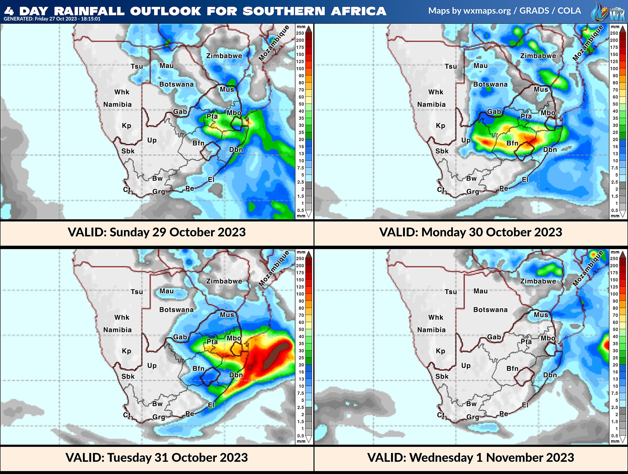
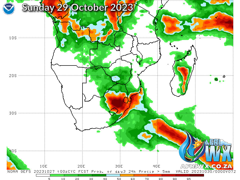
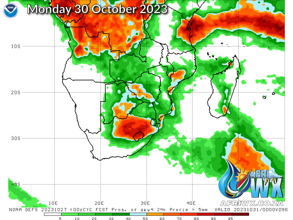
4 Day Rainfall Outlook for Southern Africa
14 Day Rainfall Outlook for Southern Africa
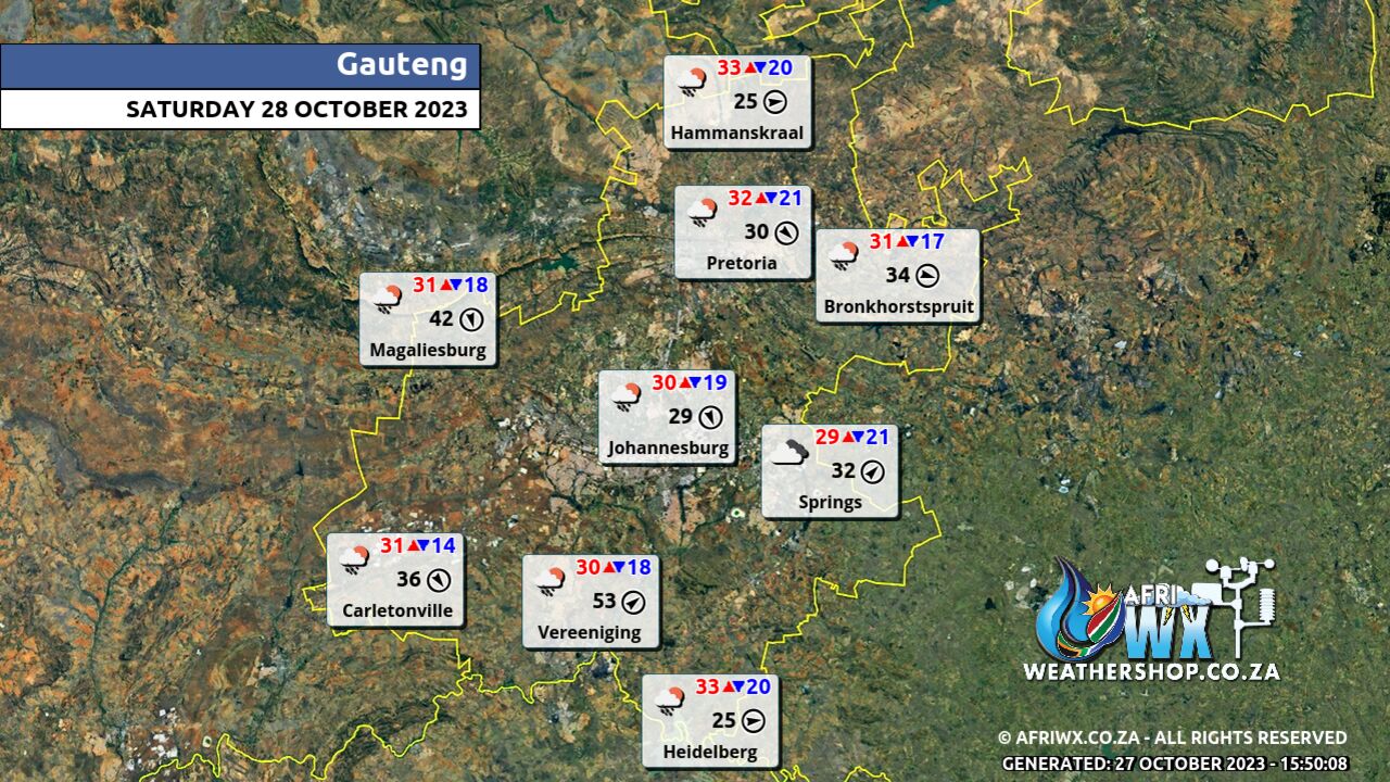
Gauteng Province Weather Map Saturday 28 October 2023
Gauteng Province Weather Meteogram Saturday 28 October 2023
Kwazulu-Natal Province Weather Map Saturday 28 October 2023
Kwazulu-Natal Province Weather Meteogram Saturday 28 October 2023
Eastern Cape Province Weather Map Saturday 28 October 2023
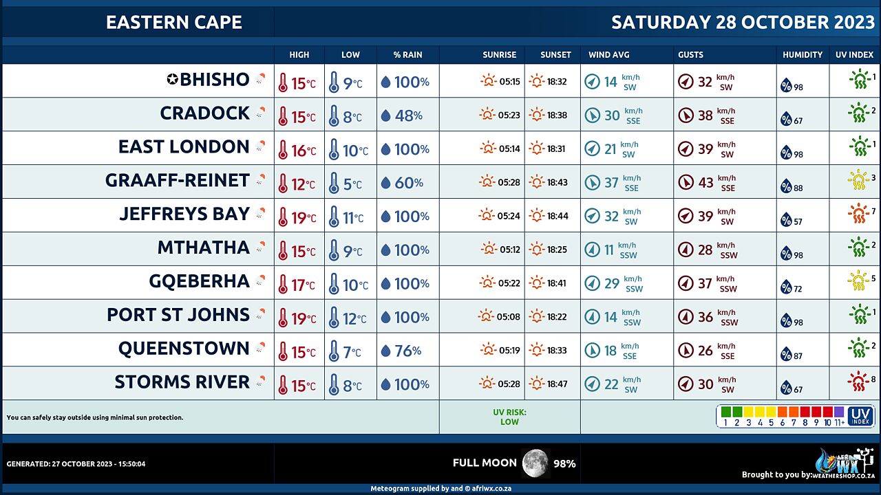
Eastern Cape Province Weather Meteogram Saturday 28 October 2023
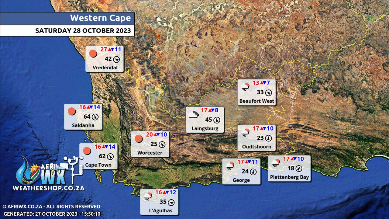
Western Cape Province Weather Map Saturday 28 October 2023
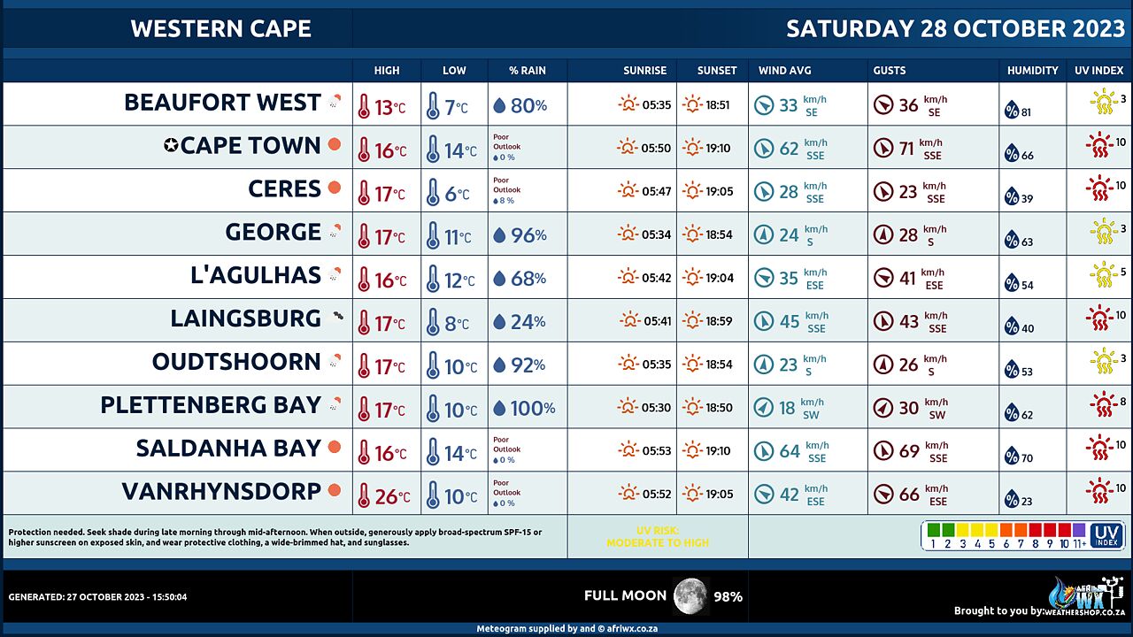
Western Cape Province Weather Meteogram Saturday 28 October 2023
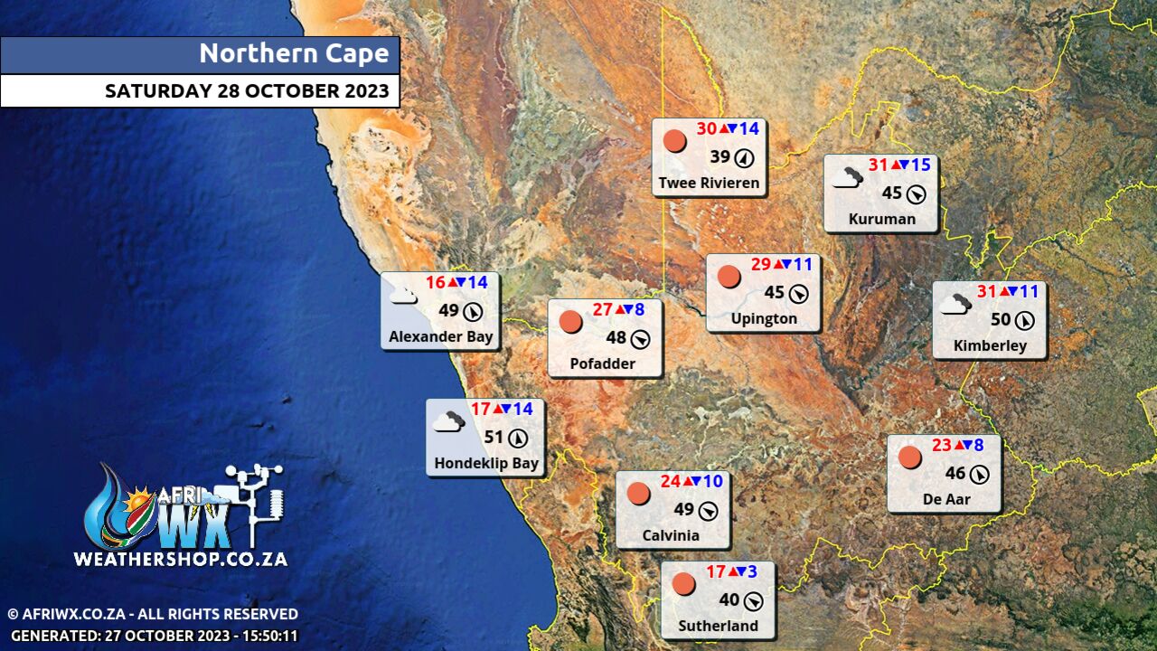
Northern Cape Province Weather Map Saturday 28 October 2023
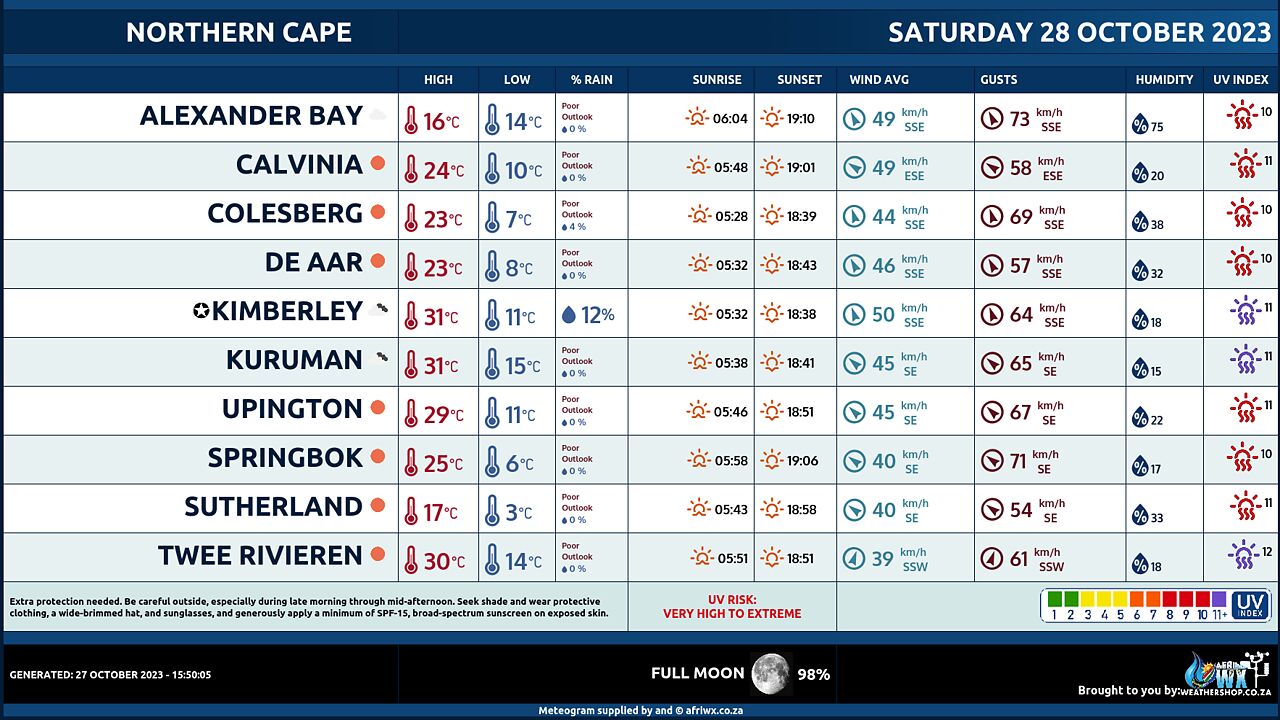
Northern Cape Province Weather Meteogram Saturday 28 October 2023
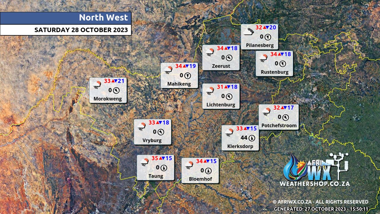
North-West Province Weather Map Saturday 28 October 2023
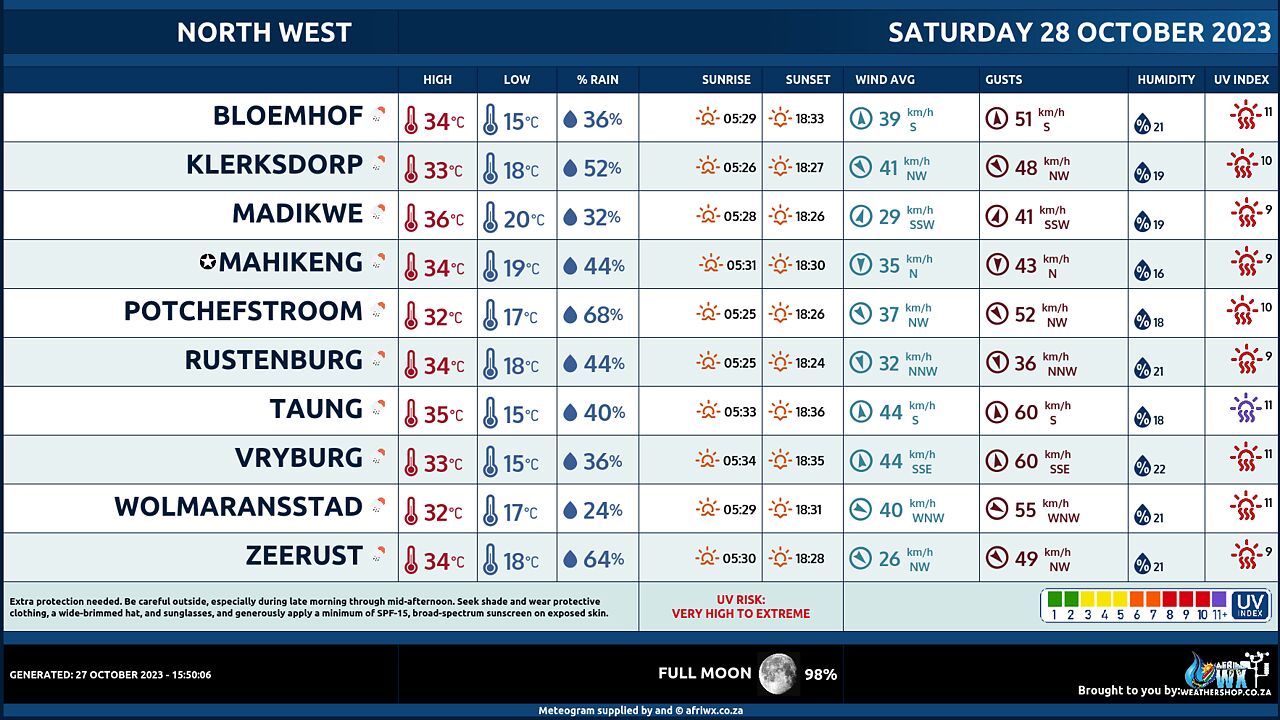
North-West Province Weather Meteogram Saturday 28 October 2023
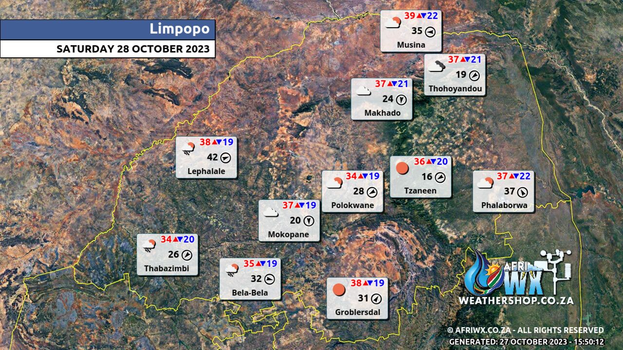
Limpopo Province Weather Map Saturday 28 October 2023
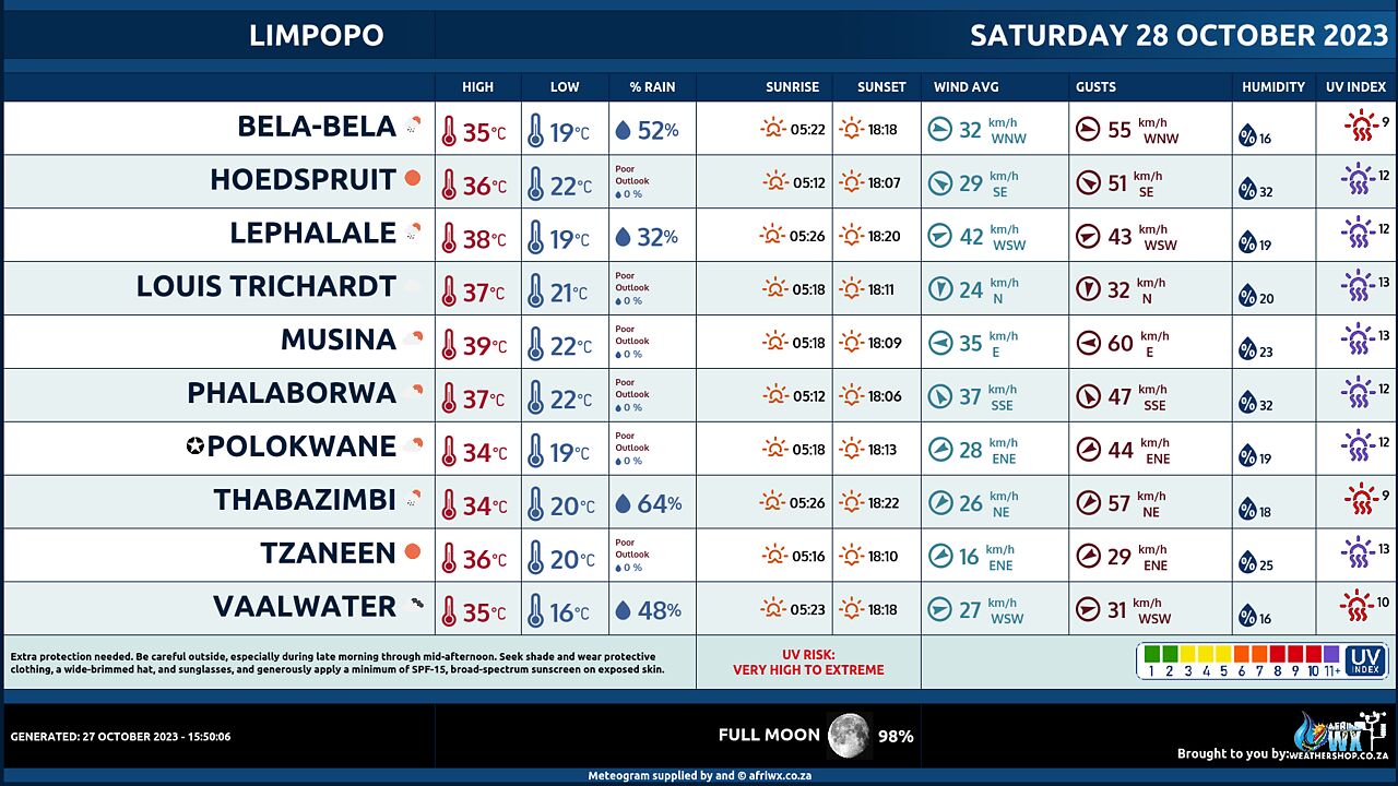
Limpopo Province Weather Meteogram Saturday 28 October 2023
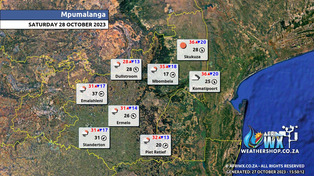
Mpumalanga Province Weather Map Saturday 28 October 2023
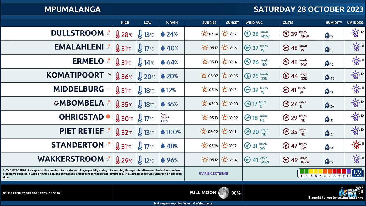
Mpumalanga Province Weather Meteogram Saturday 28 October 2023
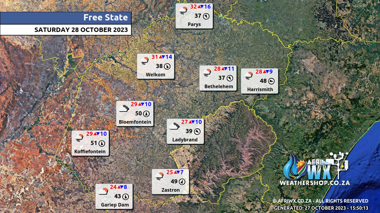
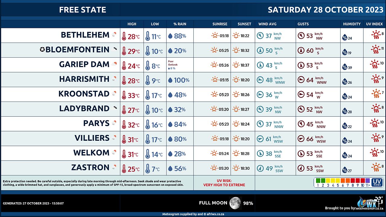
Free State Province Weather Map Saturday 28 October 2023
Free State Province Weather Meteogram Saturday 28 October 2023
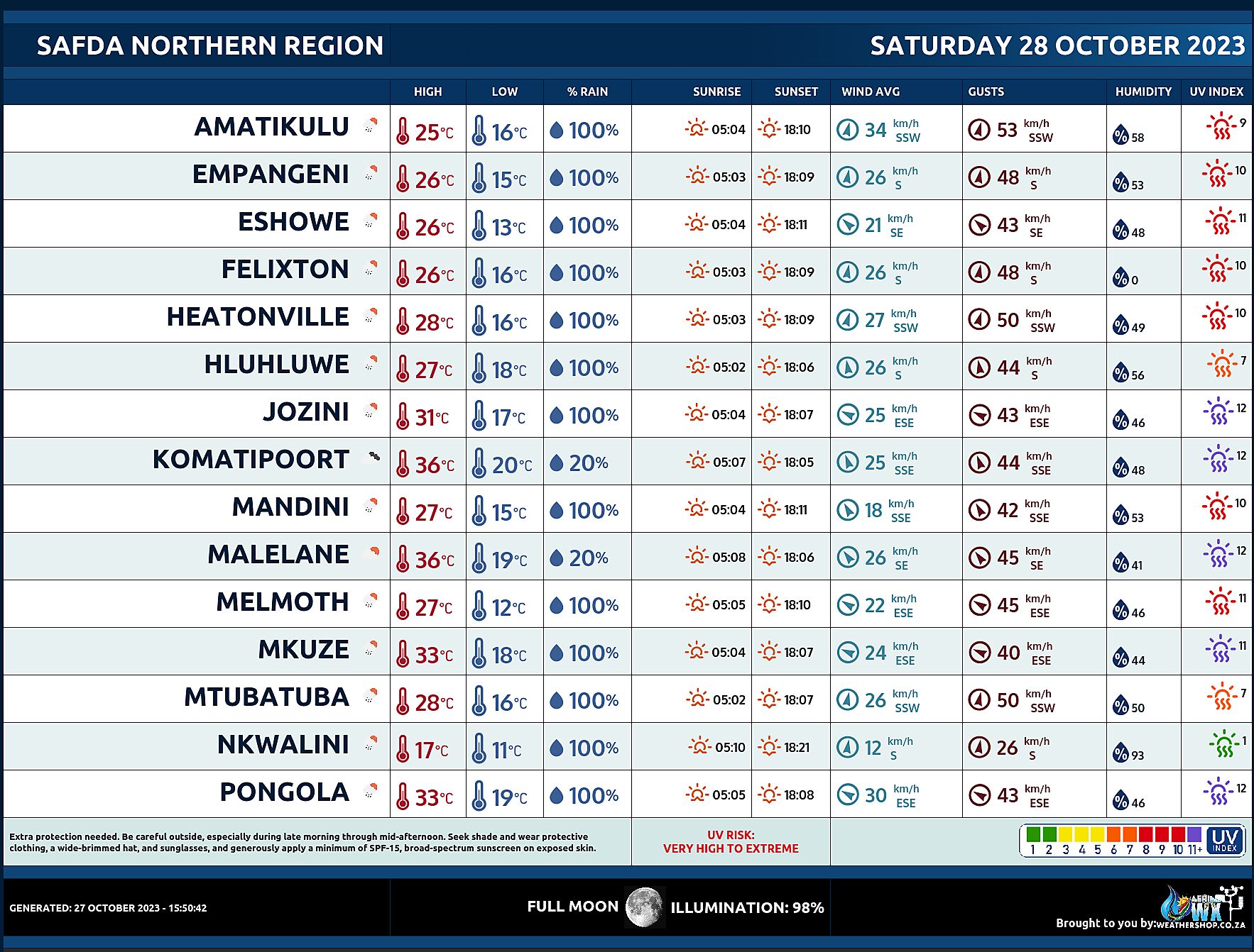
SAFDA Sugar Cane Farming (Northern Kwazulu-Natal) Weather Forecast Saturday 28 October 2023
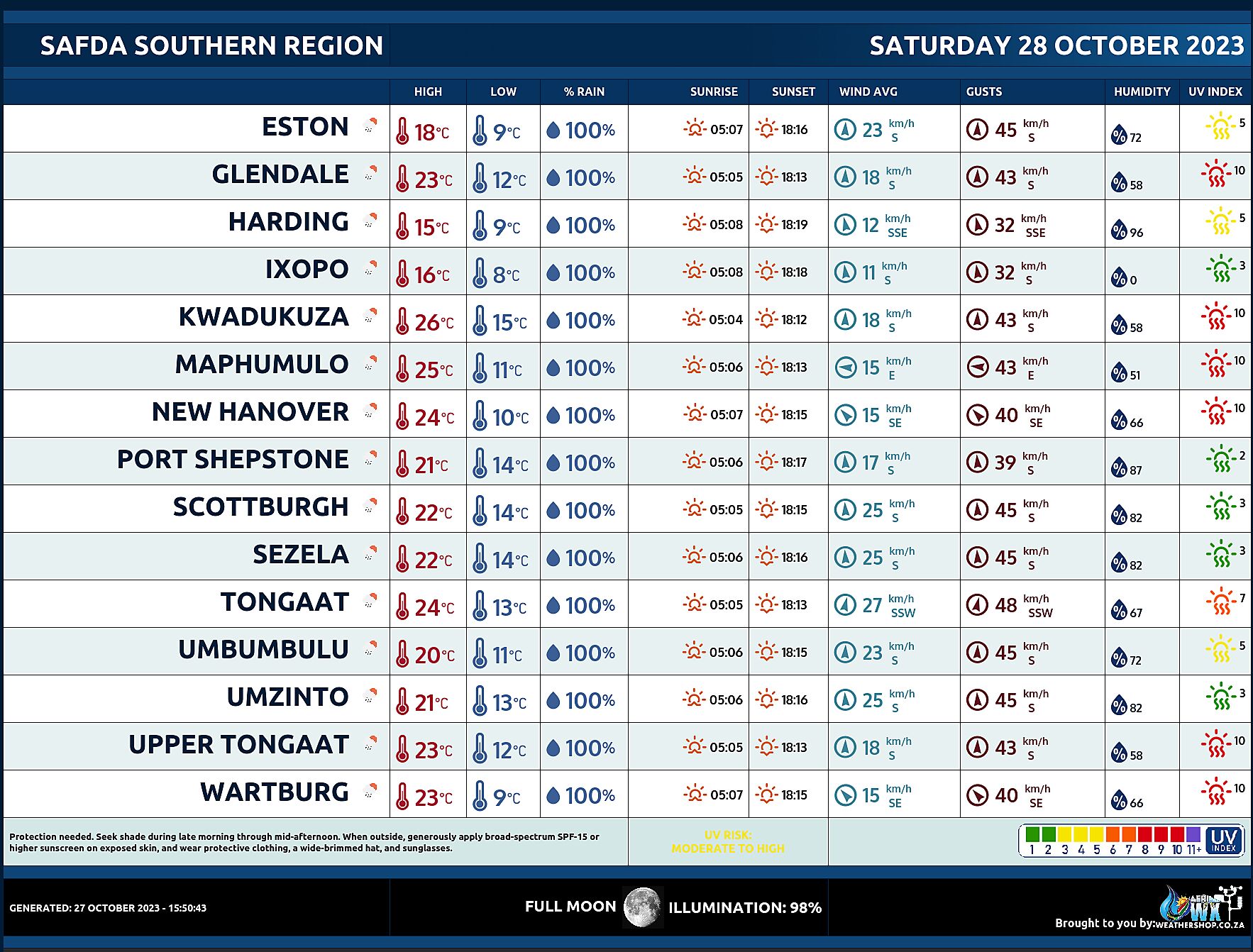
SAFDA Sugar Cane Farming (Southern Kwazulu-Natal) Weather Forecast Saturday 28 October 2023
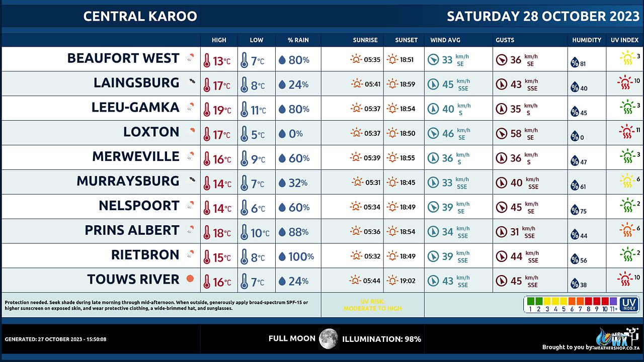
Central Karoo (Northern Cape) Farming Weather Forecast Saturday 28 October 2023
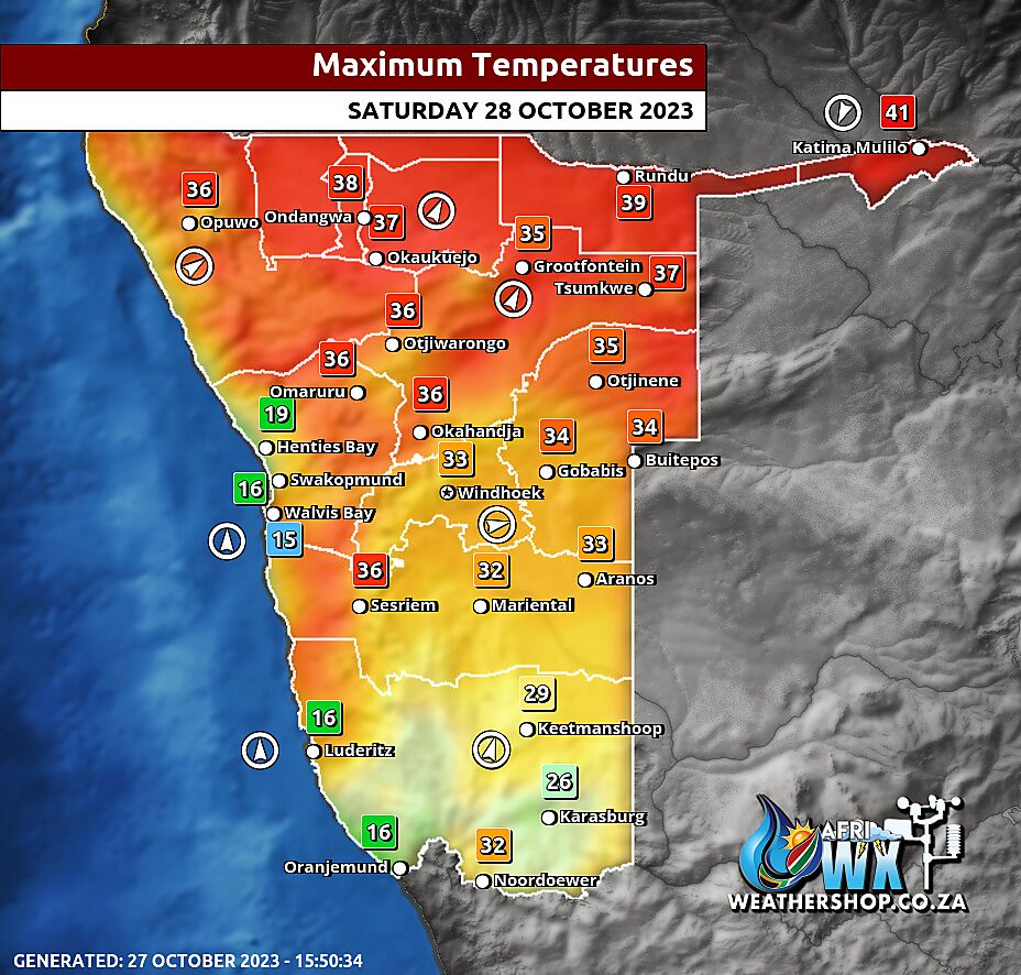
Namibia Maximum Temperatures Saturday 28 October 2023
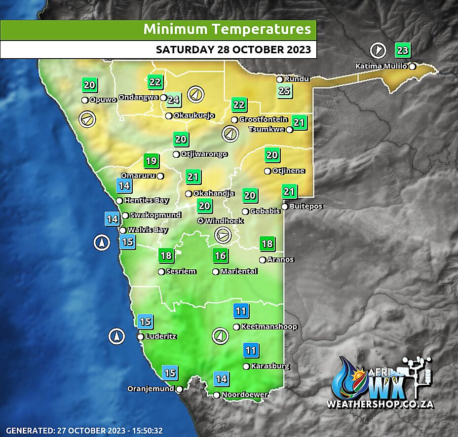
Namibia Minimum Temperatures Saturday 28 October 2023
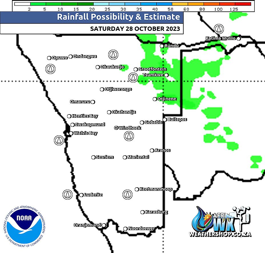
Namibia Rainfall Probability Map Saturday 28 October 2023
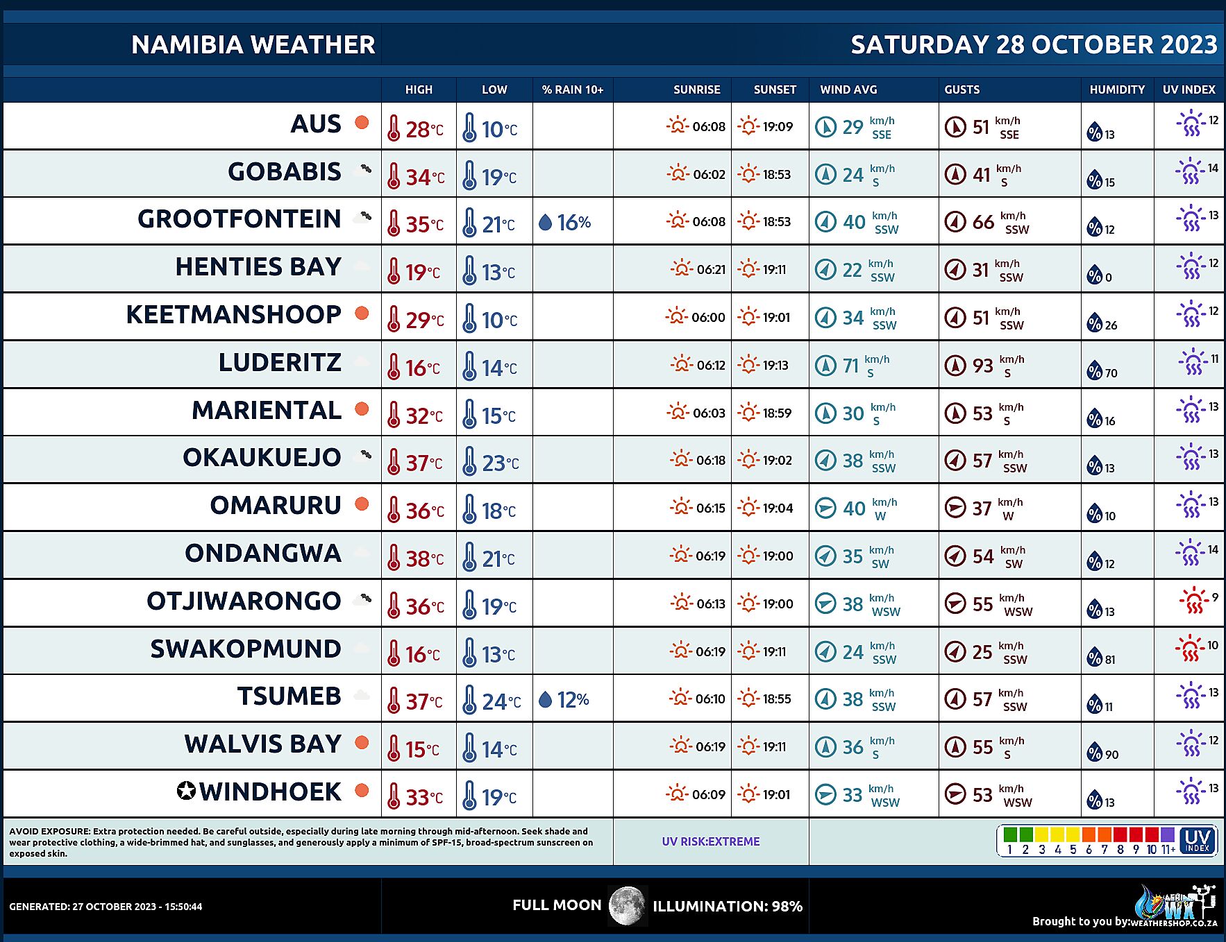
Namibia Weather Meteogram Saturday 28 October 2023
Namibia Meteorological Services METEONA Weather Forecast Saturday 28 October 2023
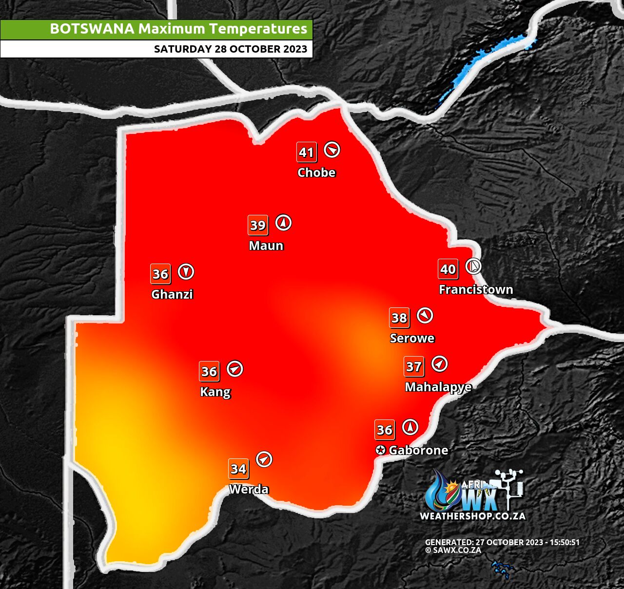
Botswana Maximum Temperatures Saturday 28 October 2023
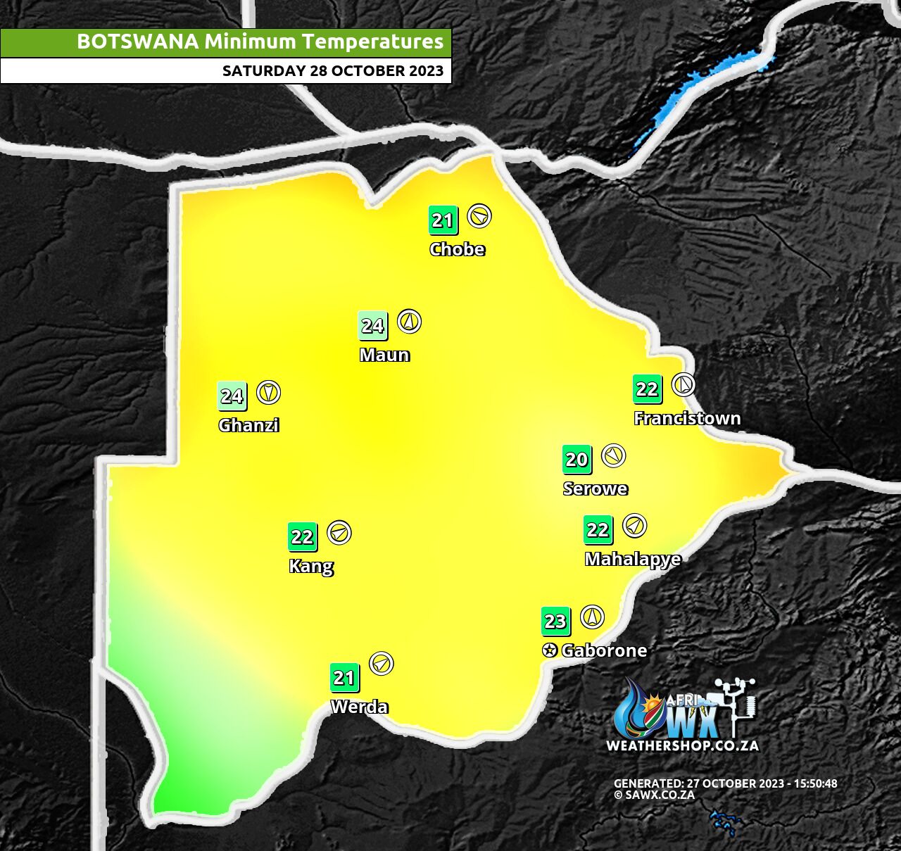
Botswana Minimum Temperatures Saturday 28 October 2023
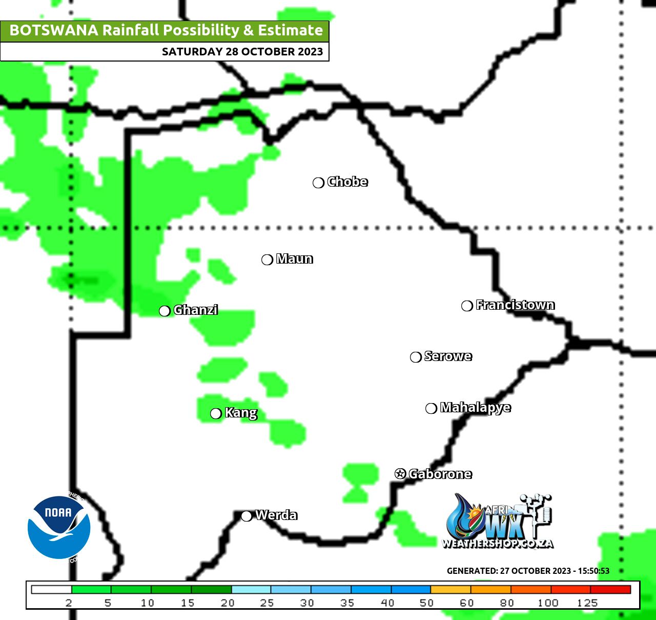
Botswana Rainfall Possibility Map Saturday 28 October 2023
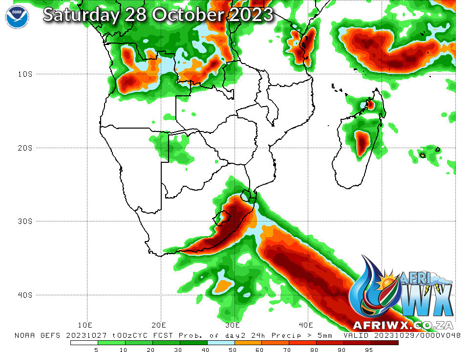
NOAA GEFS Global Ensemble Rainfall Outlook Southern Africa
JOIN OUR FREE AFRIWX WEATHER GROUP on Telegram Messenger
Please download Telegram for Android or iPhone if you want to always be up to date with the latest weather maps.
CLICK HERE TO JOIN our Telegram Group Now

